

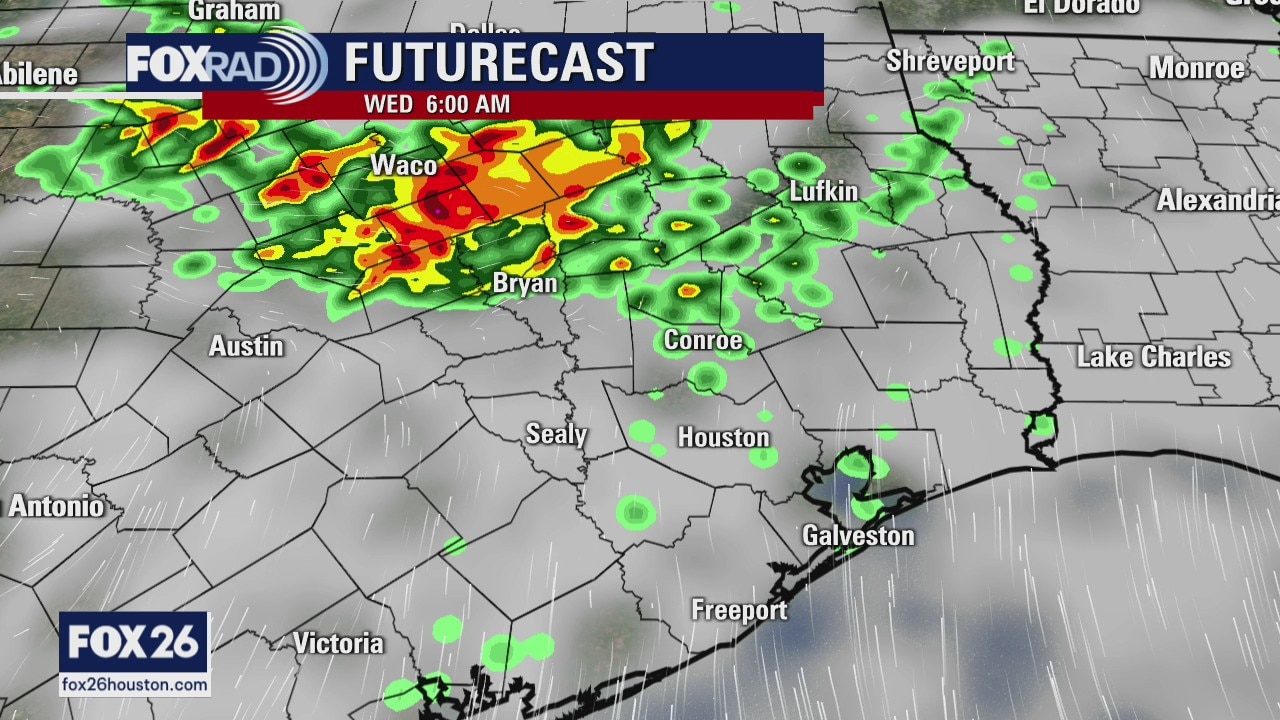
Wednesday morning forecast
We have one more day of super hot weather and the rest of the week the temps will drop a little bit. There will also be at least a chance for some showers mainly in the afternoons which could help. The tropics are active, but nothing is pointed towards the Gulf of Mexico
We have one more day of super hot weather and the rest of the week the temps will drop a little bit. There will also be at least a chance for some showers mainly in the afternoons which could help. The tropics are active, but nothing is pointed towards the Gulf of Mexico
Tuesday Evening Weather Forecast
We have one more day of super hot weather and the rest of the week the temps will drop a little bit. There will also be at least a chance for some showers mainly in the afternoons which could help. The tropics are active, but nothing is pointed towards the Gulf of Mexico.
We have one more day of super hot weather and the rest of the week the temps will drop a little bit. There will also be at least a chance for some showers mainly in the afternoons which could help. The tropics are active, but nothing is pointed towards the Gulf of Mexico.

Tuesday Afternoon Weather Forecast
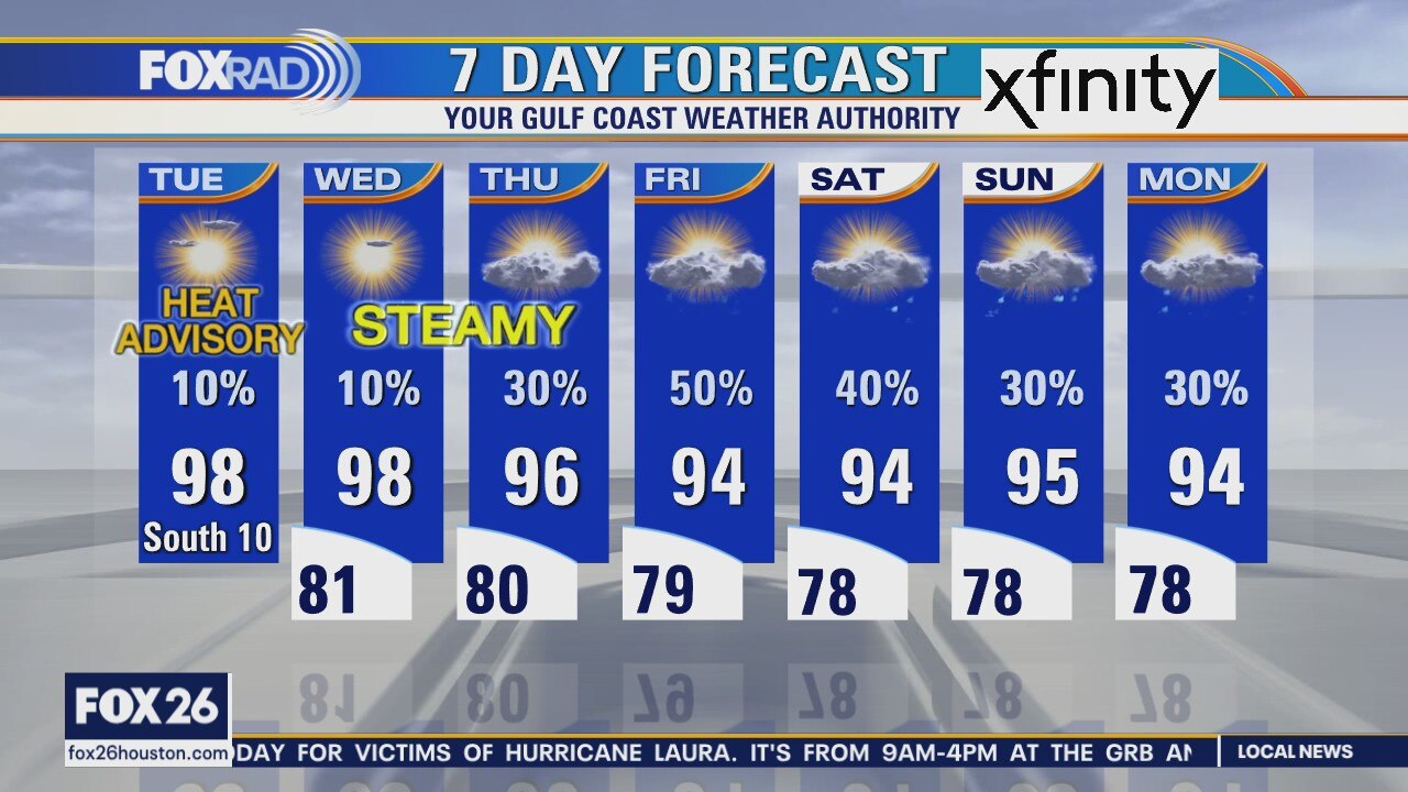
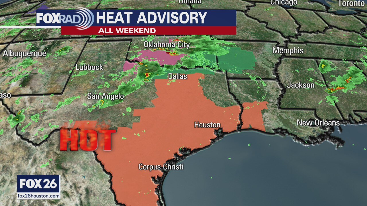
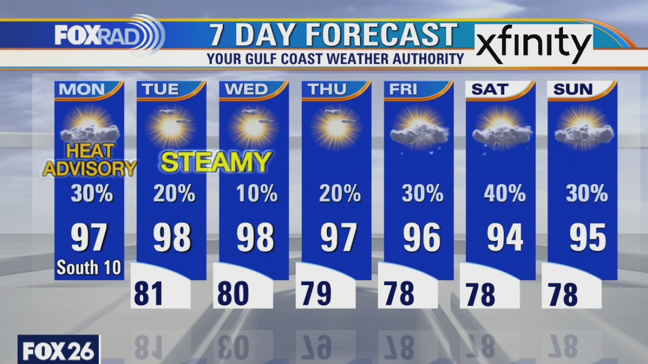
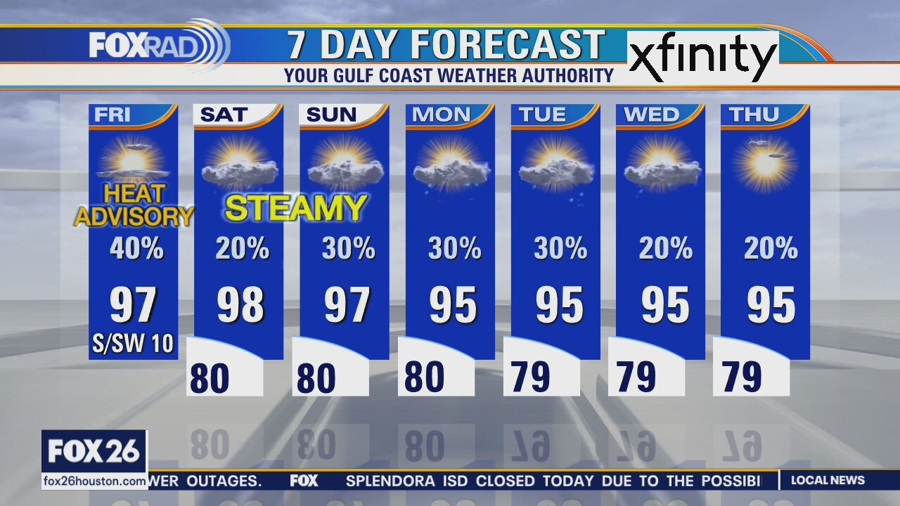
A heat advisory is in effect once again as temperatures rise into the upper 90s with very high humidity. Our humidity is so high that the last two nights have been the warmest overnights on record for both Houston and Galveston. Only isolated storms are in the forecast until Friday and Saturday when scattered showers should help with the heat. A nice cold front is still likely around the needle of next week.
A heat advisory is in effect once again as temperatures rise into the upper 90s with very high humidity. Our humidity is so high that the last two nights have been the warmest overnights on record for both Houston and Galveston. Only isolated storms are in the forecast until Friday and Saturday when scattered showers should help with the heat. A nice cold front is still likely around the needle of next week.
Tuesday weather forecast
A heat advisory is in effect once again as temperatures rise into the upper 90s with very high humidity. Our humidity is so high that the last two nights have been the warmest overnights on record for both Houston and Galveston. Only isolated storms are in the forecast until Friday and Saturday when scattered showers should help with the heat. A nice cold front is still likely around the needle of next week.
A heat advisory is in effect once again as temperatures rise into the upper 90s with very high humidity. Our humidity is so high that the last two nights have been the warmest overnights on record for both Houston and Galveston. Only isolated storms are in the forecast until Friday and Saturday when scattered showers should help with the heat. A nice cold front is still likely around the needle of next week.
More heat advisories
Hang in there for another hot week. Temps will drop a few degrees by the end of the week, which will cool us down to hot from super hot. There are still signs a front might reach us later next week. FOX 26 Chief Meteorologist Dr. Jim Siebert is hopeful.
Hang in there for another hot week. Temps will drop a few degrees by the end of the week, which will cool us down to hot from super hot. There are still signs a front might reach us later next week. FOX 26 Chief Meteorologist Dr. Jim Siebert is hopeful.

Monday Evening Weather Forecast
Hang in there for another hot week. Temps will drop a few degrees by the end of the week, which will cool us down to hot from super hot. There are still signs a front might reach us later next week.
Hang in there for another hot week. Temps will drop a few degrees by the end of the week, which will cool us down to hot from super hot. There are still signs a front might reach us later next week.
Monday weather forecast
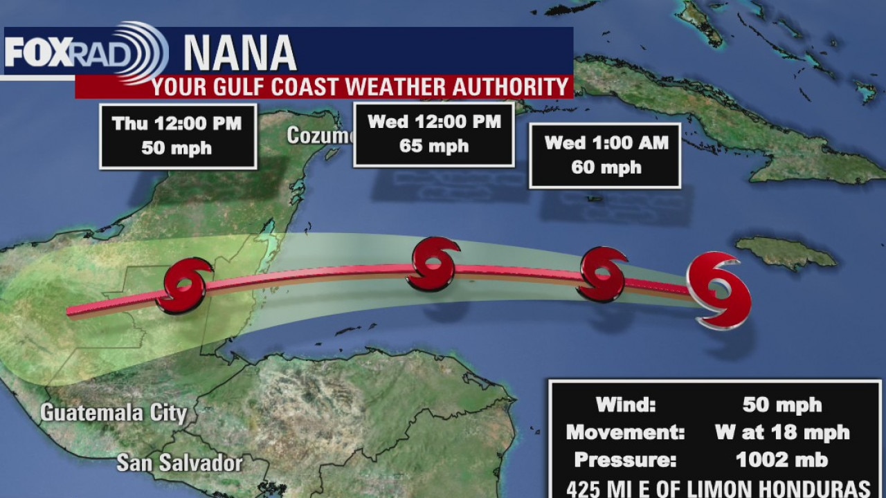
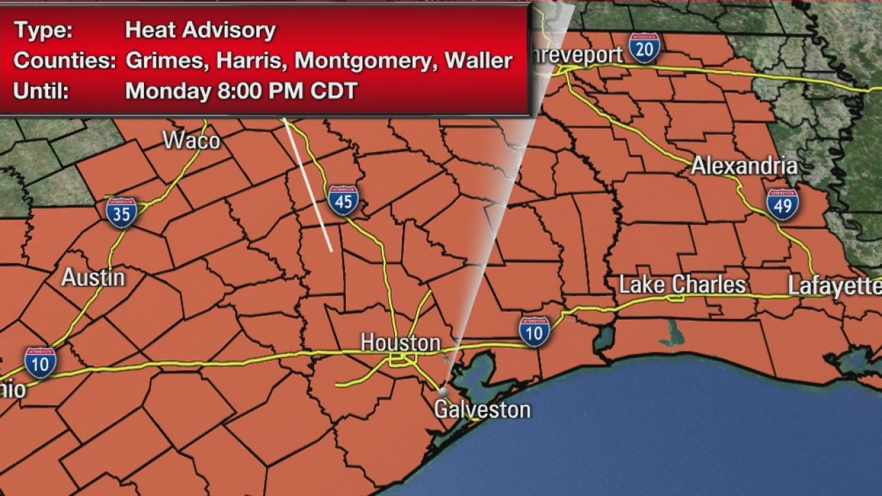
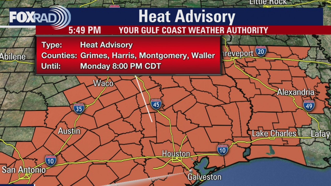
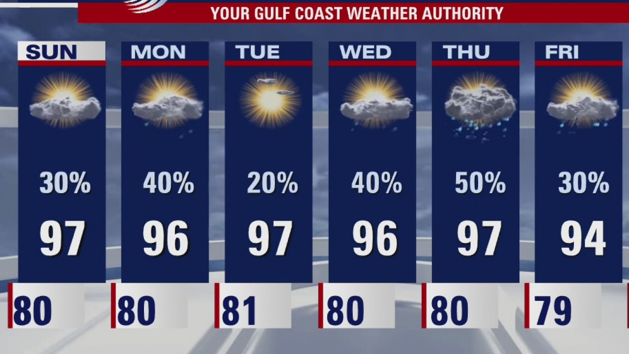
Heat and very high humidity will stay with us most of this week, but there is a real chance for a cool front around the middle part of next week. A heat advisory is in effect today through 8 p.m. and will likely be extended for Tuesday as well. A few storms are likely today with a lower chance Tuesday and Wednesday. A strong tropical wave south of Hispa?ola should stay well south of the US.
Heat and very high humidity will stay with us most of this week, but there is a real chance for a cool front around the middle part of next week. A heat advisory is in effect today through 8 p.m. and will likely be extended for Tuesday as well. A few storms are likely today with a lower chance Tuesday and Wednesday. A strong tropical wave south of Hispa?ola should stay well south of the US.
Monday morning weather forecast
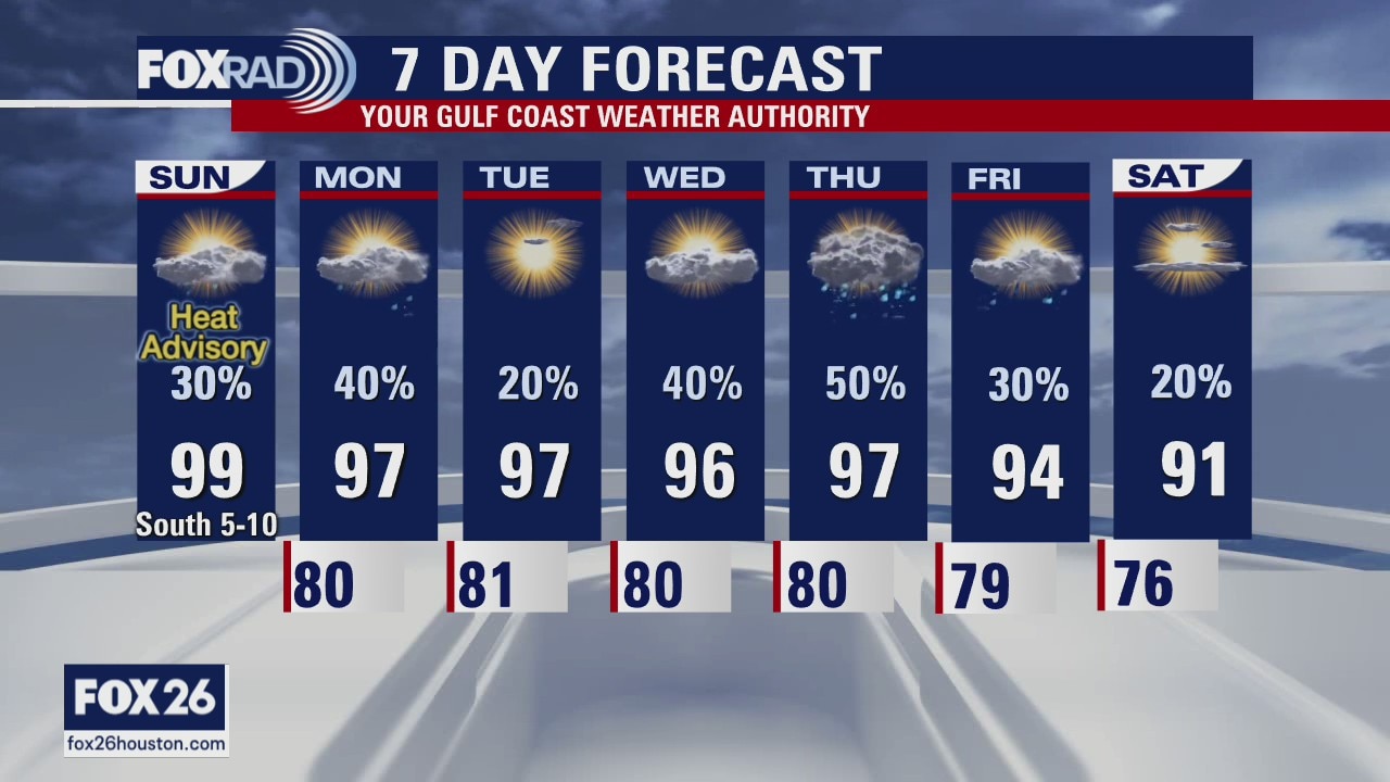
The August Houston heat will continue into September! Look for temperatures to run above average most of this week and there is not much rain to talk about. We saw Heat Advisories for both Saturday and Sunday, the National Weather Service has already reissued that Heat Advisory again Monday from 10am to 8pm. It is quiet now in the Gulf of Mexico but the tropics are heating up. No immediate cause for concern but we should stay connected as we approach the peak of hurricane season. We will expect more named storms over the next couple weeks.
The August Houston heat will continue into September! Look for temperatures to run above average most of this week and there is not much rain to talk about. We saw Heat Advisories for both Saturday and Sunday, the National Weather Service has already reissued that Heat Advisory again Monday from 10am to 8pm. It is quiet now in the Gulf of Mexico but the tropics are heating up. No immediate cause for concern but we should stay connected as we approach the peak of hurricane season. We will expect more named storms over the next couple weeks.
Sunday evening weather forecast
The August Houston heat will continue into September! Look for temperatures to run above average most of this week and there is not much rain to talk about. We saw Heat Advisories for both Saturday and Sunday, the National Weather Service has already reissued that Heat Advisory again Monday from 10am to 8pm. It is quiet now in the Gulf of Mexico but the tropics are heating up. No immediate cause for concern but we should stay connected as we approach the peak of hurricane season. We will expect more named storms over the next couple weeks.
The August Houston heat will continue into September! Look for temperatures to run above average most of this week and there is not much rain to talk about. We saw Heat Advisories for both Saturday and Sunday, the National Weather Service has already reissued that Heat Advisory again Monday from 10am to 8pm. It is quiet now in the Gulf of Mexico but the tropics are heating up. No immediate cause for concern but we should stay connected as we approach the peak of hurricane season. We will expect more named storms over the next couple weeks.
Houston-area weather forecast August 30
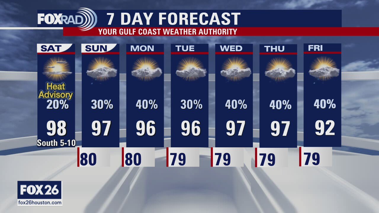
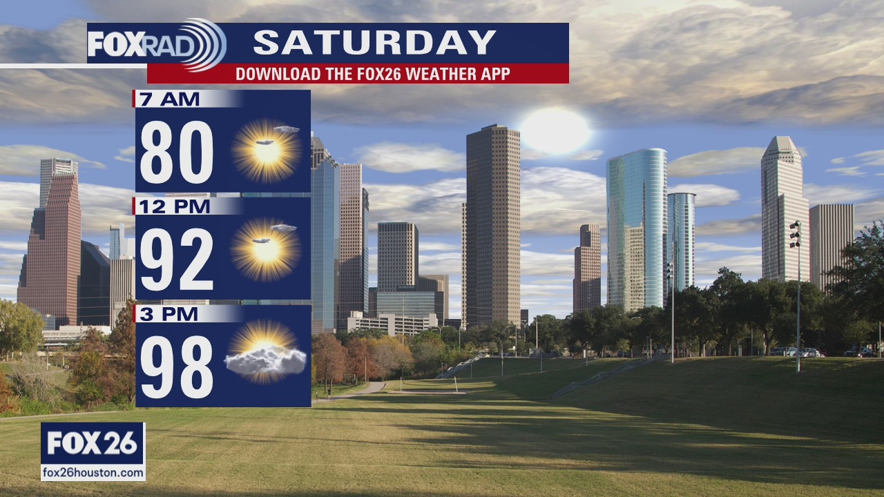
Another day, another heat advisory. Temperatures will soar this afternoon with highs reaching the upper 90s and low 100s today. It will feel much hotter, closer to 110 so make sure you stay cool. There is a chance we see a few more storms today compared to Saturday, but I believe they'll still be very isolated. Rain chances improve late next week when a front tries to move through the area.
Another day, another heat advisory. Temperatures will soar this afternoon with highs reaching the upper 90s and low 100s today. It will feel much hotter, closer to 110 so make sure you stay cool. There is a chance we see a few more storms today compared to Saturday, but I believe they'll still be very isolated. Rain chances improve late next week when a front tries to move through the area.
Sunday morning weather forecast
It's the end of August in Houston, so you know HOT is going to be in the forecast. Temperatures will be even higher than we normally expect them to be for most of this week. Some isolated storms will be around in the afternoon on Sunday. Look for a few more showers on Monday. More rain chances on Wednesday and Thursday. Be safe if you are outdoors for the rest of the weekend.
It's the end of August in Houston, so you know HOT is going to be in the forecast. Temperatures will be even higher than we normally expect them to be for most of this week. Some isolated storms will be around in the afternoon on Sunday. Look for a few more showers on Monday. More rain chances on Wednesday and Thursday. Be safe if you are outdoors for the rest of the weekend.
Houston-area weather forecast August 29
We have a Heat Advisory in place until 10PM for the entire Houston-area. Highs, today, will reach the upper 90s with those feels-like temps soaring to about 110. Stay cool! Only slight rain chances this weekend, but those chances increase as we head into next week.
We have a Heat Advisory in place until 10PM for the entire Houston-area. Highs, today, will reach the upper 90s with those feels-like temps soaring to about 110. Stay cool! Only slight rain chances this weekend, but those chances increase as we head into next week.
Get ready for serious heat!
It is going to be a very hot weekend with heat index values over 110? and only a little bit of rain. The best chance for showers will come on Monday, and the rest of next week will only have a chance for scattered showers in the afternoons.
It is going to be a very hot weekend with heat index values over 110? and only a little bit of rain. The best chance for showers will come on Monday, and the rest of next week will only have a chance for scattered showers in the afternoons.
Friday weather forecast
Hot and humid today with a heat index near 105 and highs in the mid 90s. Scattered afternoon storms are likely.
Hot and humid today with a heat index near 105 and highs in the mid 90s. Scattered afternoon storms are likely.
Friday morning weather forecast
It's going to be hot and humid through the end of the week and into the weekend. Scattered showers will pop mainly in the afternoon hours and chances for rain will drop down to only 30% by Monday. We are getting back to normal.
It's going to be hot and humid through the end of the week and into the weekend. Scattered showers will pop mainly in the afternoon hours and chances for rain will drop down to only 30% by Monday. We are getting back to normal.
Hot and humid forecast
It's going to be hot and humid through the end of the week and into the weekend. Scattered showers will pop mainly in the afternoon hours and chances for rain will drop down to only 30 percent by Monday. We are getting back to normal.
It's going to be hot and humid through the end of the week and into the weekend. Scattered showers will pop mainly in the afternoon hours and chances for rain will drop down to only 30 percent by Monday. We are getting back to normal.
More than 60,000 homes without power in Jefferson County due to Hurricane Laura
Hurricane Laura damage was minimal in Port Arthur. But folks could be without power in some areas for weeks.
Hurricane Laura damage was minimal in Port Arthur. But folks could be without power in some areas for weeks.
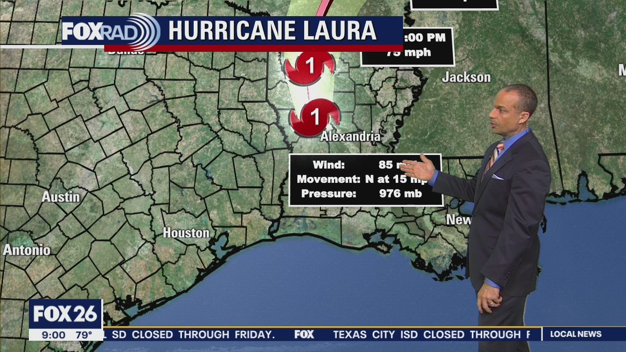
Hurricane Laura update and Houston area forecast 9AM
Hurricane Laura continues to move inland and is now a Category 1 storm, the Houston area forecast and Stephen Morgan takes a look at the brewing storms in the Atlantic.
Hurricane Laura continues to move inland and is now a Category 1 storm, the Houston area forecast and Stephen Morgan takes a look at the brewing storms in the Atlantic.

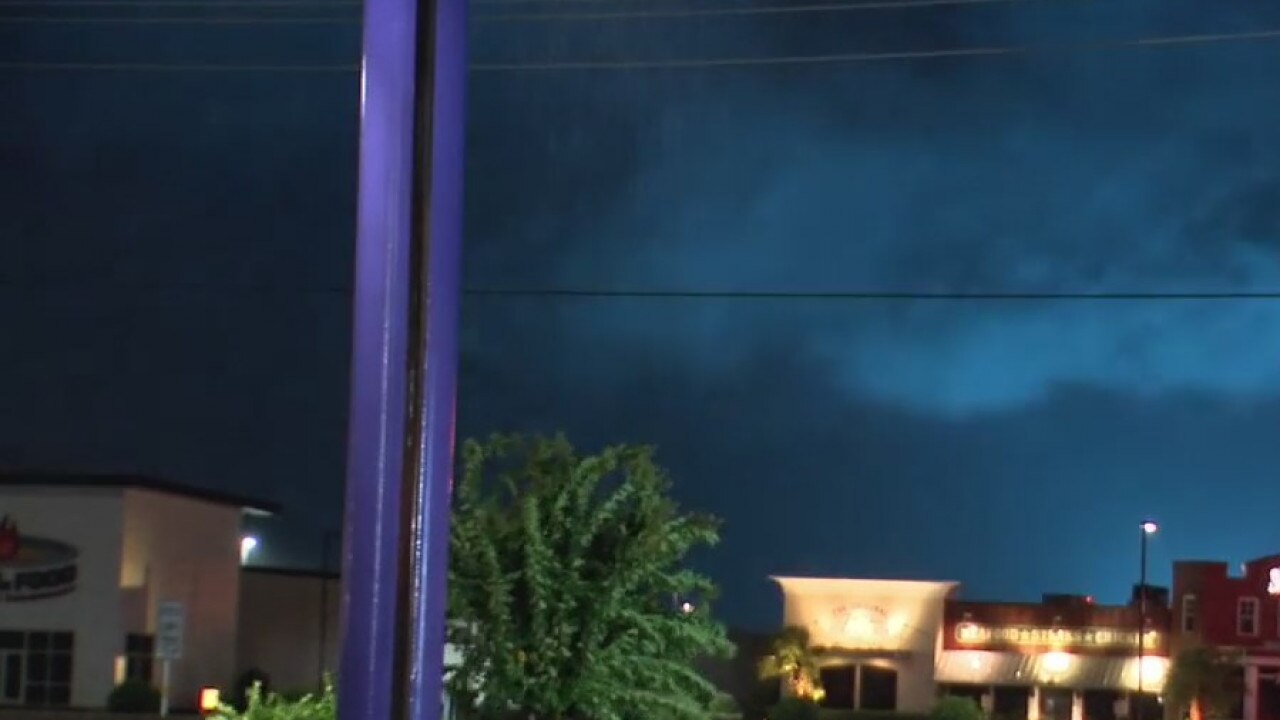
Hurricane Laura brings heavy wind damage to Lake Charles
Several businesses and homes in ruin after 150 mph Hurricane Laura winds rip through Lake Charles.
Several businesses and homes in ruin after 150 mph Hurricane Laura winds rip through Lake Charles.

Hurricane Laura moves across Louisiana as Category 2
Laura is weakening as it moves inland, but winds are still gusting to hurricane force in central and western Louisiana. The system will move through places like Shreveport and Little Rock over the next 24 hours. Its effects on the Houston area were minimal.
Laura is weakening as it moves inland, but winds are still gusting to hurricane force in central and western Louisiana. The system will move through places like Shreveport and Little Rock over the next 24 hours. Its effects on the Houston area were minimal.