

Tuesday weather forecast
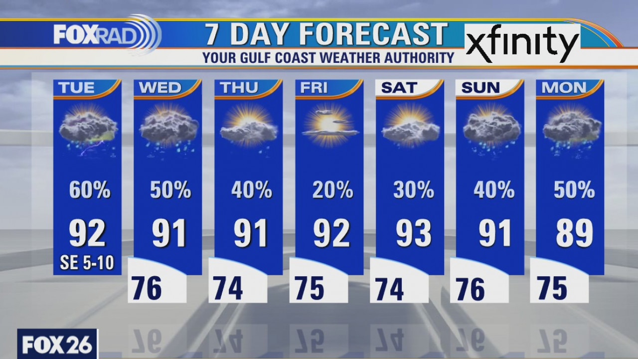
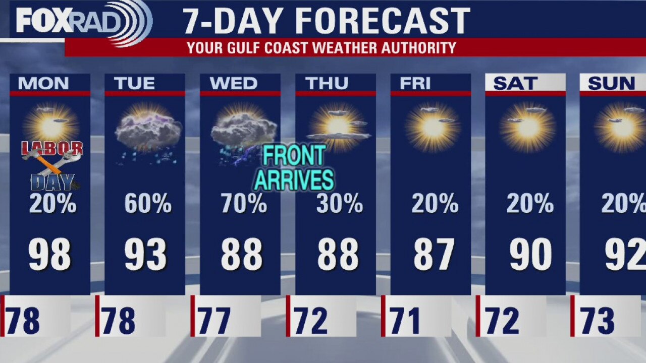
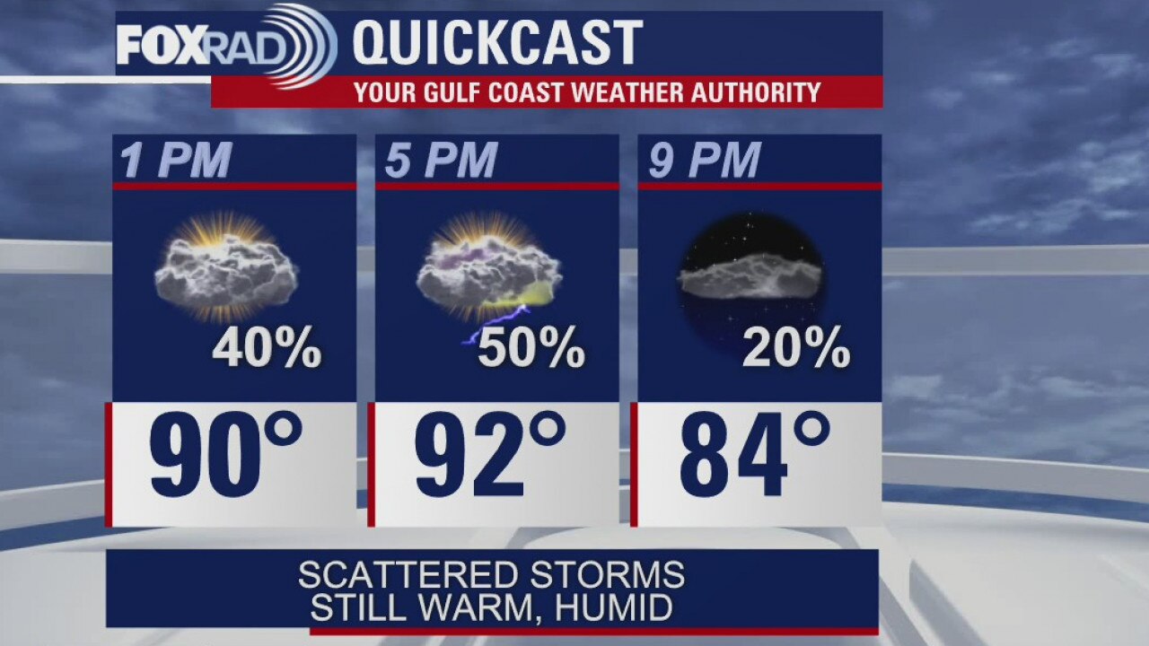
Scattered showers and storms look likely today and tomorrow with partly sunny and warm conditions in between. Our much anticipated cold front looks like it will stall just to our northwest. Still, clouds and rain will help to tamp down temperatures a bit, so look for highs in the Upper 80s and low 90s with lows in the mid 70s
Scattered showers and storms look likely today and tomorrow with partly sunny and warm conditions in between. Our much anticipated cold front looks like it will stall just to our northwest. Still, clouds and rain will help to tamp down temperatures a bit, so look for highs in the Upper 80s and low 90s with lows in the mid 70s
Evening weather for Monday, Sept. 7
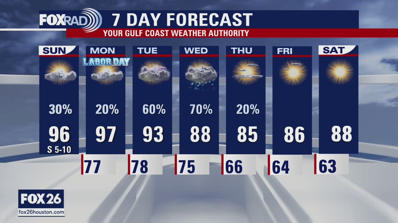
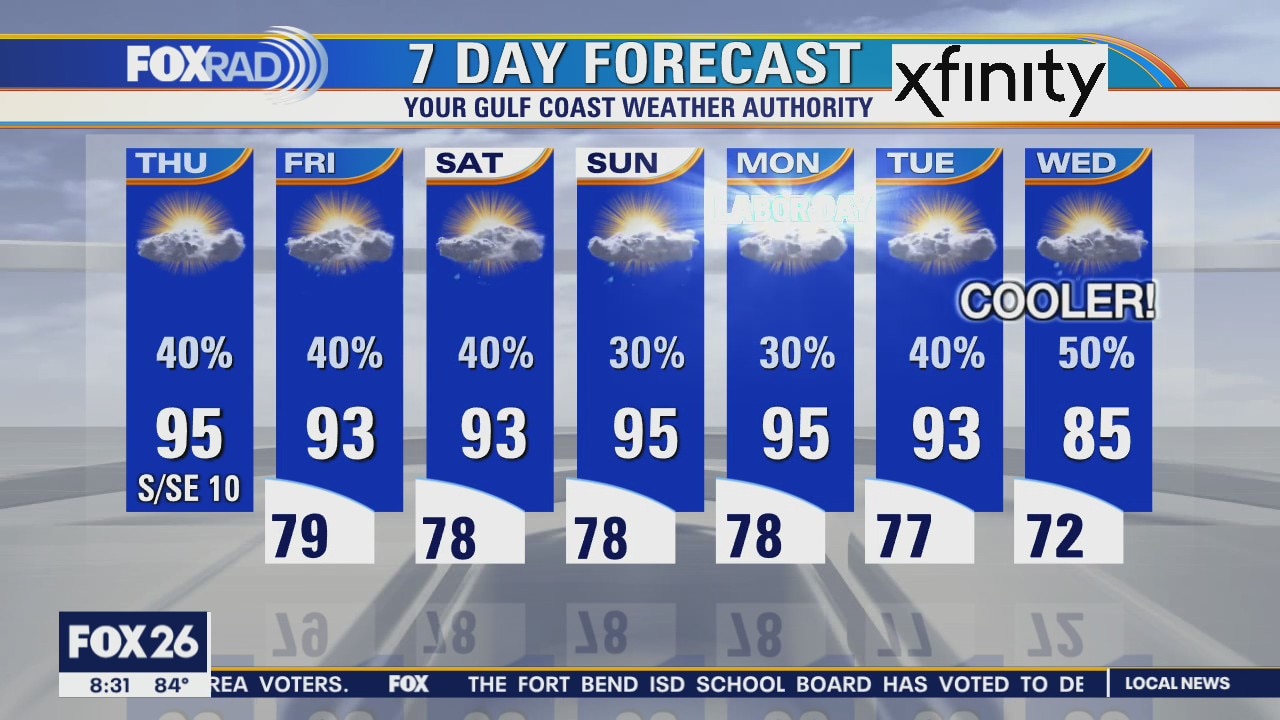
The first week of September will have a few rain chances but mostly will just be hot. The cold front that was expected on Wednesday has fizzled out. We'll be left with slightly cooler afternoon highs but most of that is just from cloud cover and not Canadian air. Look for temperatures to stay close to the seasonal averages for most of the week.
The first week of September will have a few rain chances but mostly will just be hot. The cold front that was expected on Wednesday has fizzled out. We'll be left with slightly cooler afternoon highs but most of that is just from cloud cover and not Canadian air. Look for temperatures to stay close to the seasonal averages for most of the week.
Monday weather forecast
Partly cloudy skies today will give way to a few afternoon showers and storms. Highs in the mid to upper 90s.
Partly cloudy skies today will give way to a few afternoon showers and storms. Highs in the mid to upper 90s.

Monday weather forecast
Partly cloudy skies today will give way to a few afternoon showers and storms. Highs in the mid to upper 90s. Chance of rain: 30 percent.
Partly cloudy skies today will give way to a few afternoon showers and storms. Highs in the mid to upper 90s. Chance of rain: 30 percent.
Monday morning weather forecast
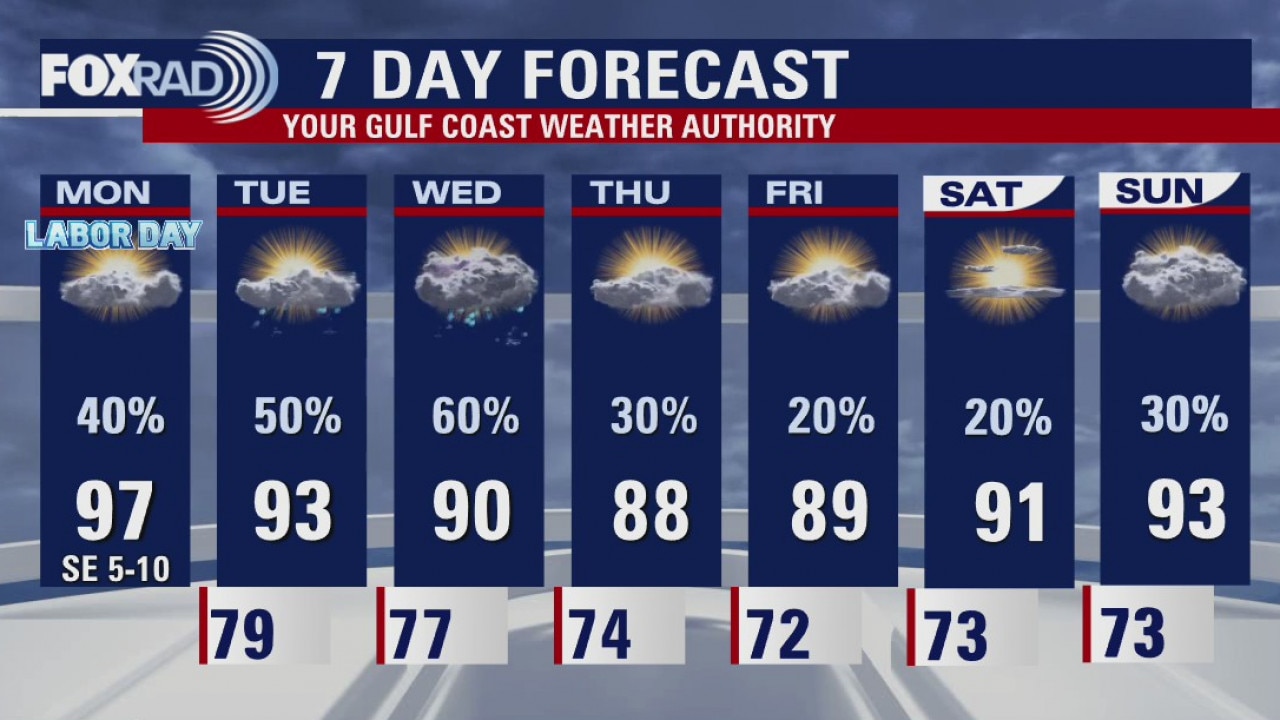
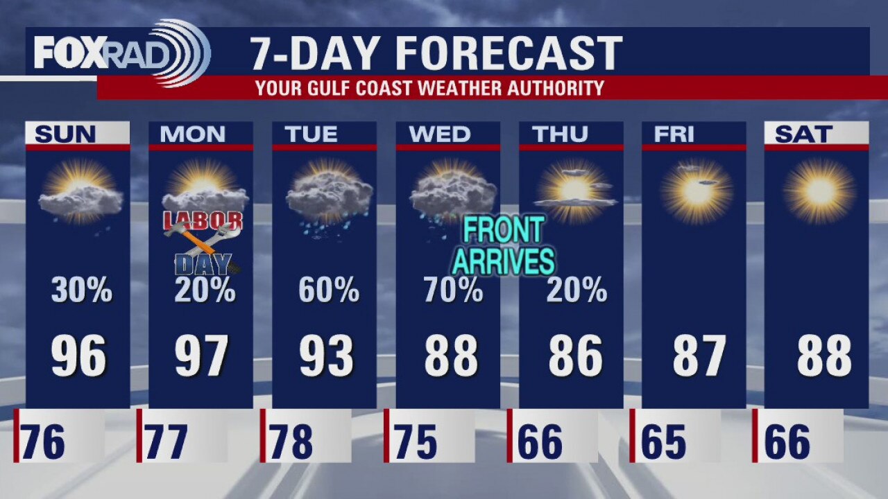
Looking pretty good for Labor Day in Houston. A few afternoon storms and it will be hot! Look for the "feels like" temps over 100. The much anticipated cold front is starting to show a bit less "cold" to it. We'll still notice the change but I don't think all of us will see morning lows in the 60s.
Looking pretty good for Labor Day in Houston. A few afternoon storms and it will be hot! Look for the "feels like" temps over 100. The much anticipated cold front is starting to show a bit less "cold" to it. We'll still notice the change but I don't think all of us will see morning lows in the 60s.
Sunday evening weather forecast
Looking pretty good for Labor Day in Houston. A few afternoon storms and it will be hot! Look for the "feels like" temps over 100. The much anticipated cold front is starting to show a bit less "cold" to it. We'll still notice the change but I don't think all of us will see morning lows in the 60s.
Looking pretty good for Labor Day in Houston. A few afternoon storms and it will be hot! Look for the "feels like" temps over 100. The much anticipated cold front is starting to show a bit less "cold" to it. We'll still notice the change but I don't think all of us will see morning lows in the 60s.
Houston-area weather forecast September 6
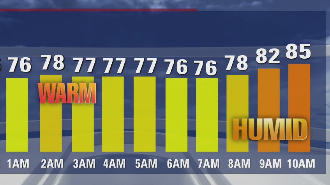
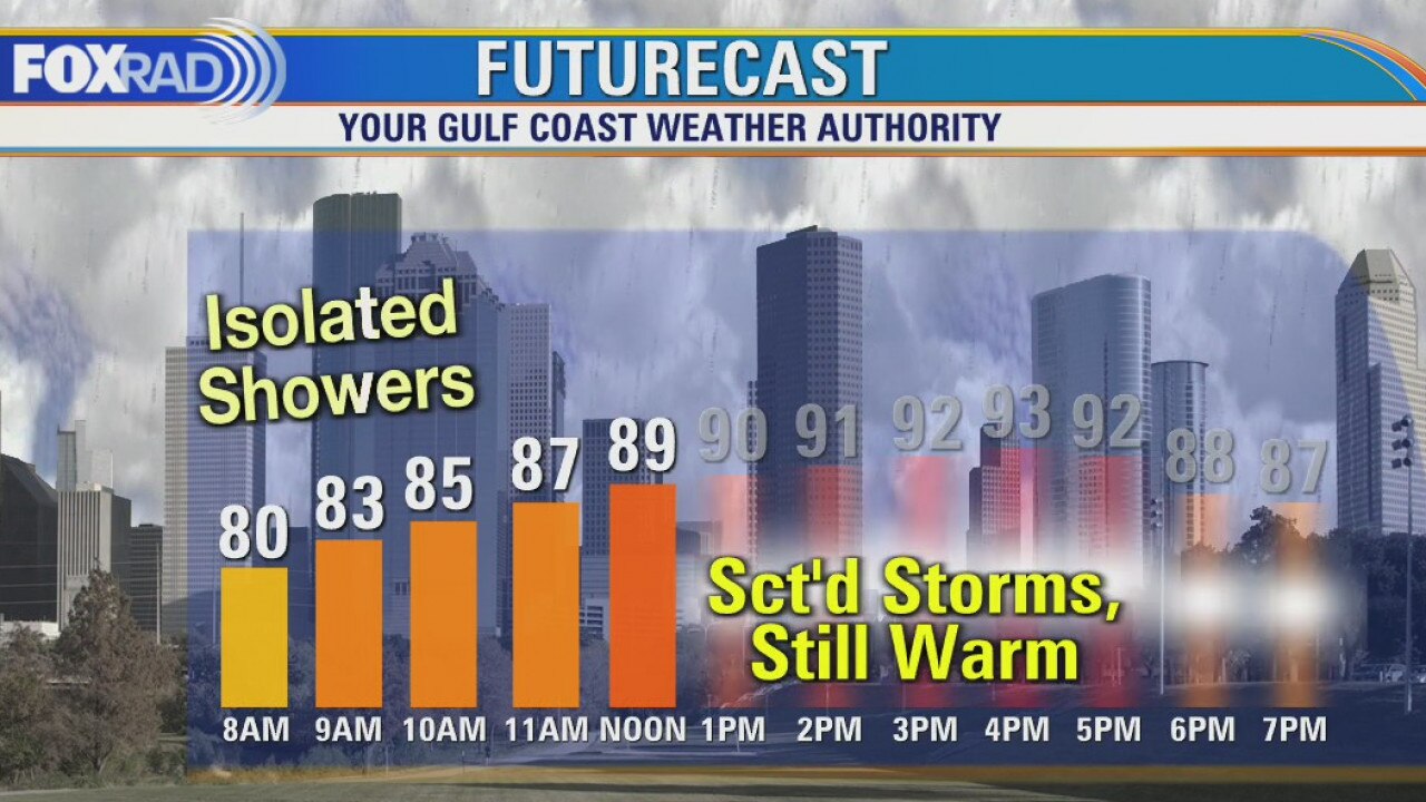
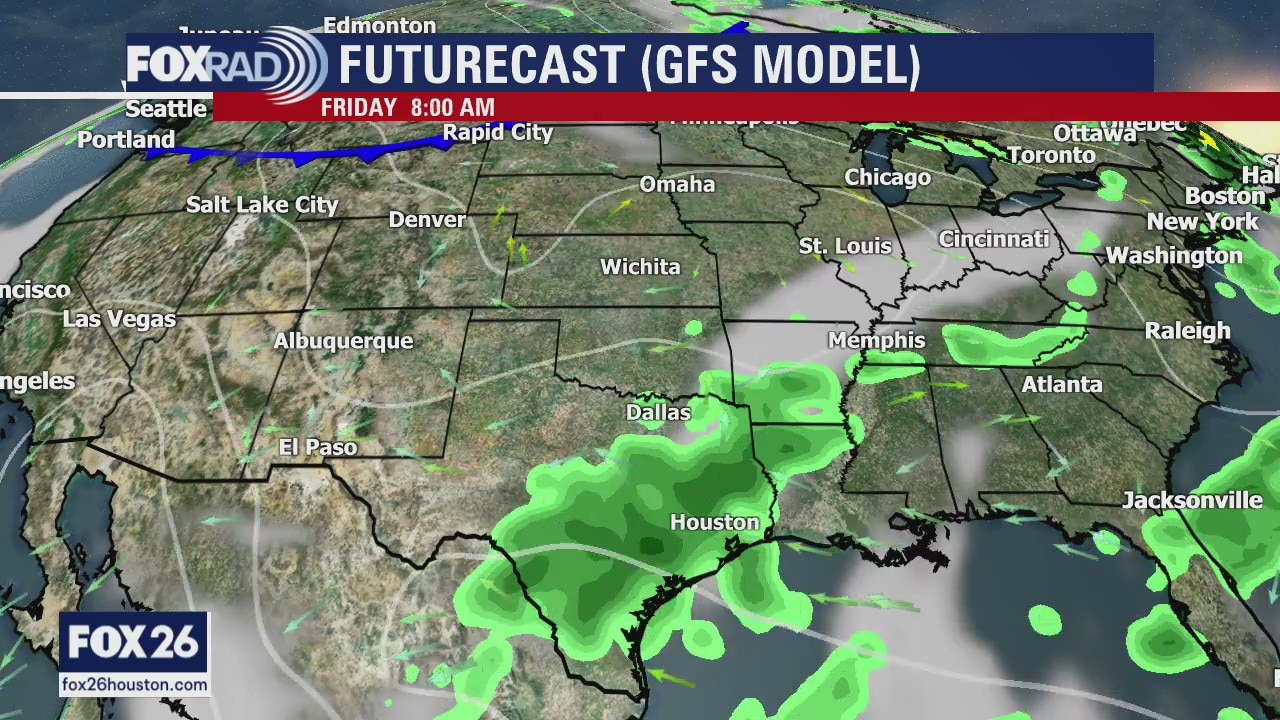
Temperatures a bit more tolerable this morning, but still on the mild side. Rain should hold off until later this afternoon when a few storms will be possible, mainly after 3PM. Highs will reach the mid 90s again. Labor Day is looking hot ahead of a cold front that is set to arrive Wednesday and Thursday, dropping our temperatures (but more importantly, drying out our air)!
Temperatures a bit more tolerable this morning, but still on the mild side. Rain should hold off until later this afternoon when a few storms will be possible, mainly after 3PM. Highs will reach the mid 90s again. Labor Day is looking hot ahead of a cold front that is set to arrive Wednesday and Thursday, dropping our temperatures (but more importantly, drying out our air)!
Sunday morning weather forecast
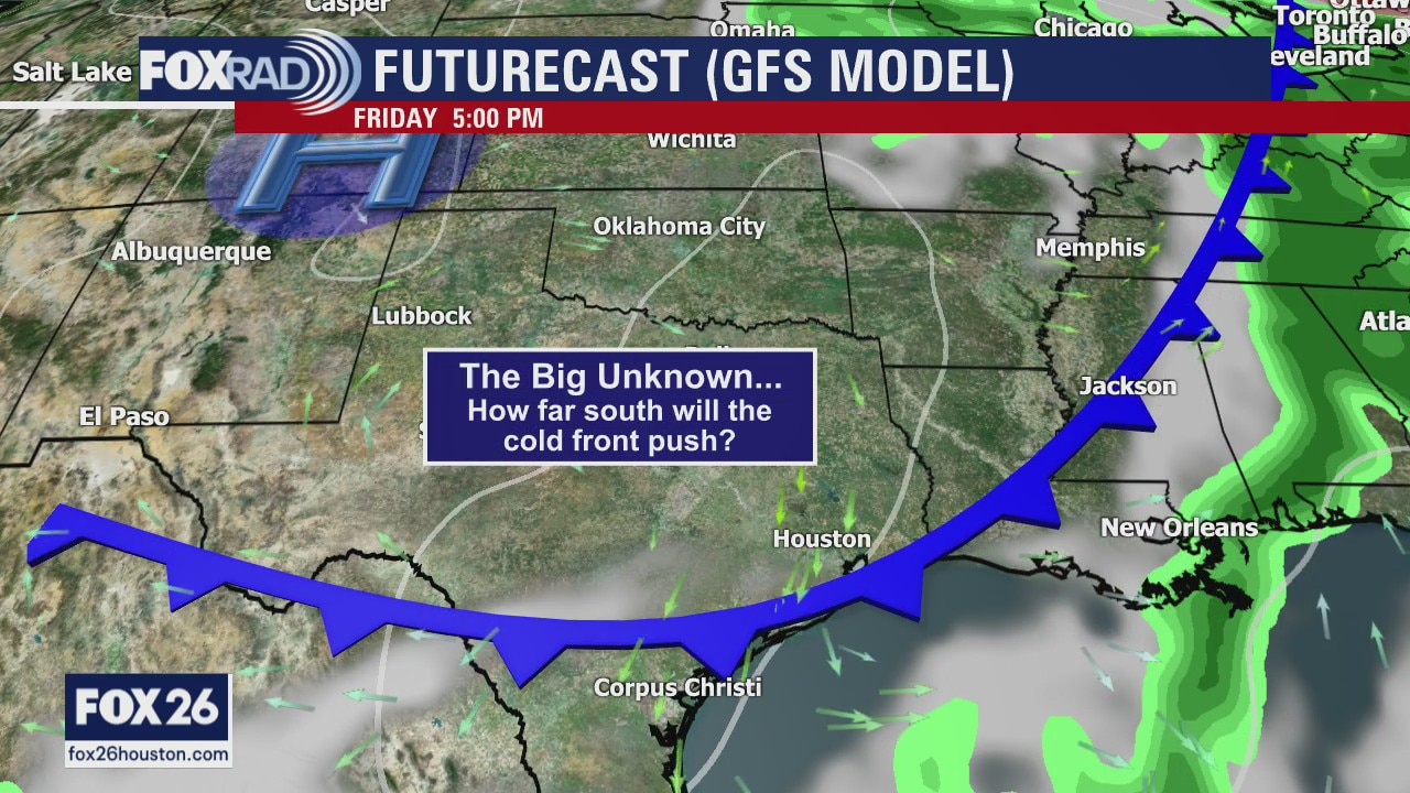
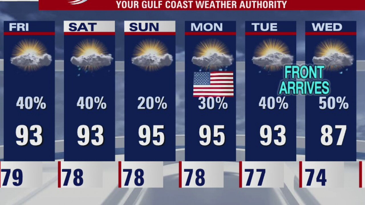
The cold front is still expected to arrive on Wednesday. It will bring some chances along with it for Tuesday and Wednesday. Look for a sunny and clear end to the week.
The cold front is still expected to arrive on Wednesday. It will bring some chances along with it for Tuesday and Wednesday. Look for a sunny and clear end to the week.
Labor Day Weekend Weather Forecast
Our Labor Day weekend is off to a mostly dry start, although we are dealing with a few coastal showers and storms. There will be plenty of dry time today, but this afternoon our rain chances will increase with storms possible. Our opportunities for rain will remain through the weekend, but decrease as we head into Labor Day. After Monday, we then focus on a cold front set to move through Wednesday & Thursday.
Our Labor Day weekend is off to a mostly dry start, although we are dealing with a few coastal showers and storms. There will be plenty of dry time today, but this afternoon our rain chances will increase with storms possible. Our opportunities for rain will remain through the weekend, but decrease as we head into Labor Day. After Monday, we then focus on a cold front set to move through Wednesday & Thursday.
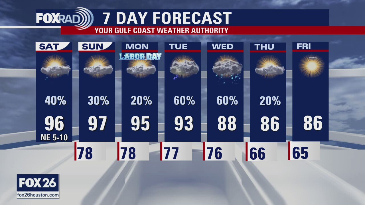
Saturday morning weather forecast
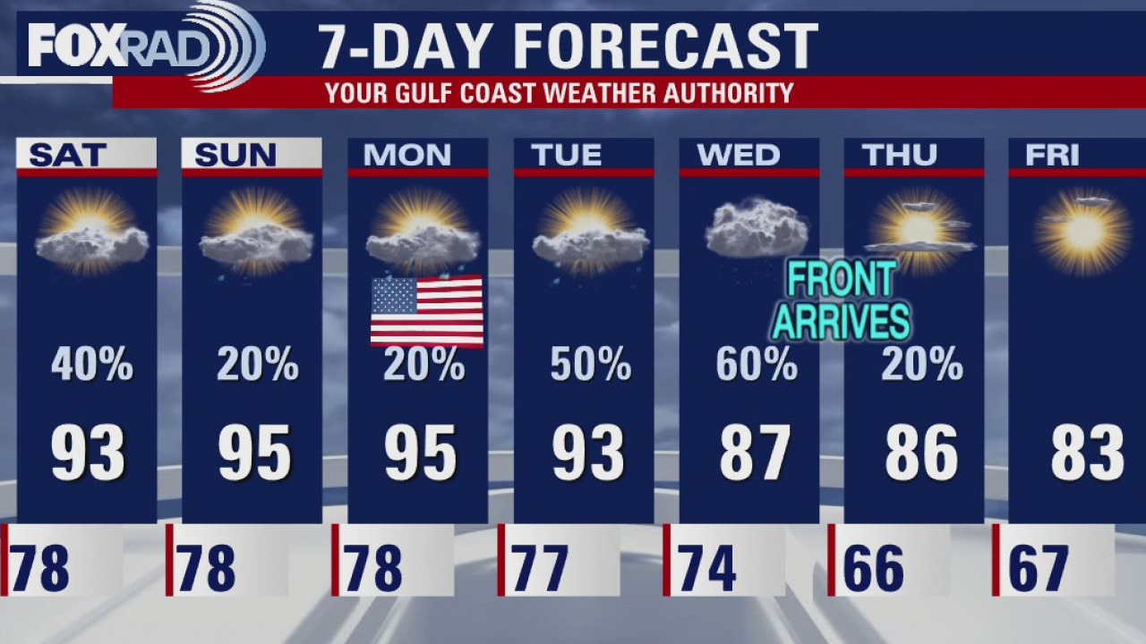
The weekend looks warm and humid with some scattered showers on Saturday and less rain activities Sunday and Labor Day. The front still looks on track to arrive on Wednesday which will bring us a good chance for rain followed by drier and cooler weather for the rest of next week
The weekend looks warm and humid with some scattered showers on Saturday and less rain activities Sunday and Labor Day. The front still looks on track to arrive on Wednesday which will bring us a good chance for rain followed by drier and cooler weather for the rest of next week
Warm and humid weekend
The weekend looks warm and humid with some scattered showers on Saturday and fewer rain activities Sunday and Labor Day. The front still looks on track to arrive on Wednesday which will bring us a good chance for rain followed by drier and cooler weather for the rest of next week.
The weekend looks warm and humid with some scattered showers on Saturday and fewer rain activities Sunday and Labor Day. The front still looks on track to arrive on Wednesday which will bring us a good chance for rain followed by drier and cooler weather for the rest of next week.
Scattered showers and storms throughout Labor Day weekend
With scattered showers and storms returning to the forecast, the excessive heat and humidity should be ramped down a bit. Watch for a few hefty storms this afternoon with highs in the low to mid 90s. For the Labor Day weekend, scattered storms look likely on Saturday, then isolated for Sunday and Monday with typical heat and humidity. By Wednesday, a nice-looking cold front is expected and we could feel 60s by Thursday morning!
With scattered showers and storms returning to the forecast, the excessive heat and humidity should be ramped down a bit. Watch for a few hefty storms this afternoon with highs in the low to mid 90s. For the Labor Day weekend, scattered storms look likely on Saturday, then isolated for Sunday and Monday with typical heat and humidity. By Wednesday, a nice-looking cold front is expected and we could feel 60s by Thursday morning!
Isolated storms to roll through Houston throughout the day
With scattered showers and storms returning to the forecast, the excessive heat and humidity should be ramped down a bit. Watch for a few hefty storms this afternoon with highs in the low to mid 90s. For the Labor Day weekend, scattered storms look likely on Saturday, then isolated for Sunday and Monday with typical heat and humidity. By Wednesday, a nice-looking cold front is expected and we could feel 60s by Thursday morning!
With scattered showers and storms returning to the forecast, the excessive heat and humidity should be ramped down a bit. Watch for a few hefty storms this afternoon with highs in the low to mid 90s. For the Labor Day weekend, scattered storms look likely on Saturday, then isolated for Sunday and Monday with typical heat and humidity. By Wednesday, a nice-looking cold front is expected and we could feel 60s by Thursday morning!
Friday morning weather forecast
We can expect highs in the 90s and lows in the 70s all the way through the holiday weekend. We are still tracking a front which will arrive by Wed and while it?s not going to be cold, it will definitely be cooler and drier.
We can expect highs in the 90s and lows in the 70s all the way through the holiday weekend. We are still tracking a front which will arrive by Wed and while it?s not going to be cold, it will definitely be cooler and drier.
Hot temps thru the holiday weekend
We can expect highs in the 90s and lows in the 70s all the way through the holiday weekend. We are still tracking a front which will arrive by Wednesday and while it?s not going to be cold, it will definitely be cooler and drier.
We can expect highs in the 90s and lows in the 70s all the way through the holiday weekend. We are still tracking a front which will arrive by Wednesday and while it?s not going to be cold, it will definitely be cooler and drier.
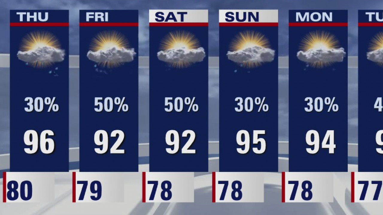
Thursday weather forecast
A historic string of record warm mornings continued today with lows in the mid 80s across the area. Some slight changes have arrived, though. Look for more cloud cover and some scattered showers today through the holiday weekend. It will remain very warm and humid, but not quite as hot. Our much anticipated cold front is still on the way for the middle of next week.
A historic string of record warm mornings continued today with lows in the mid 80s across the area. Some slight changes have arrived, though. Look for more cloud cover and some scattered showers today through the holiday weekend. It will remain very warm and humid, but not quite as hot. Our much anticipated cold front is still on the way for the middle of next week.
Cooler temps?
The rest of the week will bring somewhat cooler temperatures across southeast Texas and the Houston area. There will also be a daily chance for rain with the best chance is coming on Friday. A cold front is still on track to arrive here by Tuesday night or early Wednesday.
The rest of the week will bring somewhat cooler temperatures across southeast Texas and the Houston area. There will also be a daily chance for rain with the best chance is coming on Friday. A cold front is still on track to arrive here by Tuesday night or early Wednesday.
Wednesday evening weather forecast
The rest of the week will bring somewhat cooler temperatures across SE Texas and the Houston area. There will also be a daily chance for rain with the best chance is coming on Fri. A cold front is still on track to arrive here by Tue night or early Wed.
The rest of the week will bring somewhat cooler temperatures across SE Texas and the Houston area. There will also be a daily chance for rain with the best chance is coming on Fri. A cold front is still on track to arrive here by Tue night or early Wed.

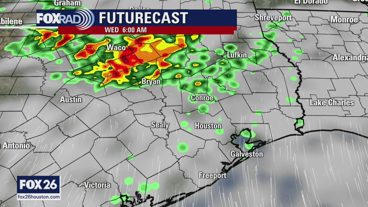
Wednesday weather forecast
A heat advisory is in effect for the 6th day in a row with highs expected to hit the mid and upper 90s and heat index values near 108. There may be a few storms, especially north and west of Houston. Look for scattered showers tomorrow and higher rain chances for Friday and Saturday. We?re still expected a nice cool front around Wednesday of next week.
A heat advisory is in effect for the 6th day in a row with highs expected to hit the mid and upper 90s and heat index values near 108. There may be a few storms, especially north and west of Houston. Look for scattered showers tomorrow and higher rain chances for Friday and Saturday. We?re still expected a nice cool front around Wednesday of next week.
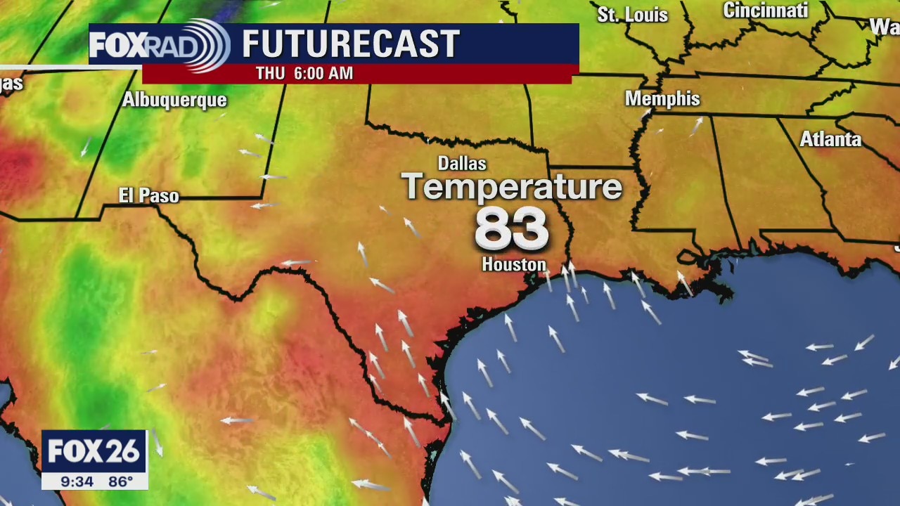
Wednesday morning forecast
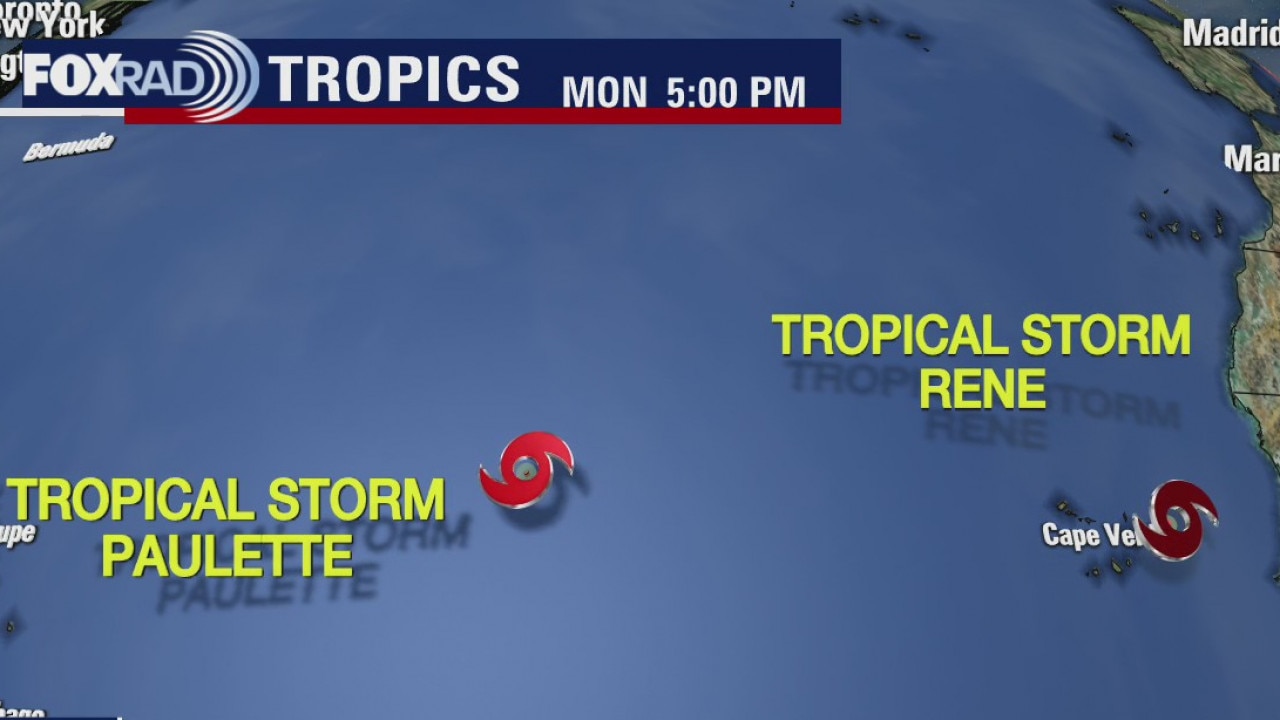
We have one more day of super hot weather and the rest of the week the temps will drop a little bit. There will also be at least a chance for some showers mainly in the afternoons which could help. The tropics are active, but nothing is pointed towards the Gulf of Mexico
We have one more day of super hot weather and the rest of the week the temps will drop a little bit. There will also be at least a chance for some showers mainly in the afternoons which could help. The tropics are active, but nothing is pointed towards the Gulf of Mexico