

Houston-area weather forecast 10/24
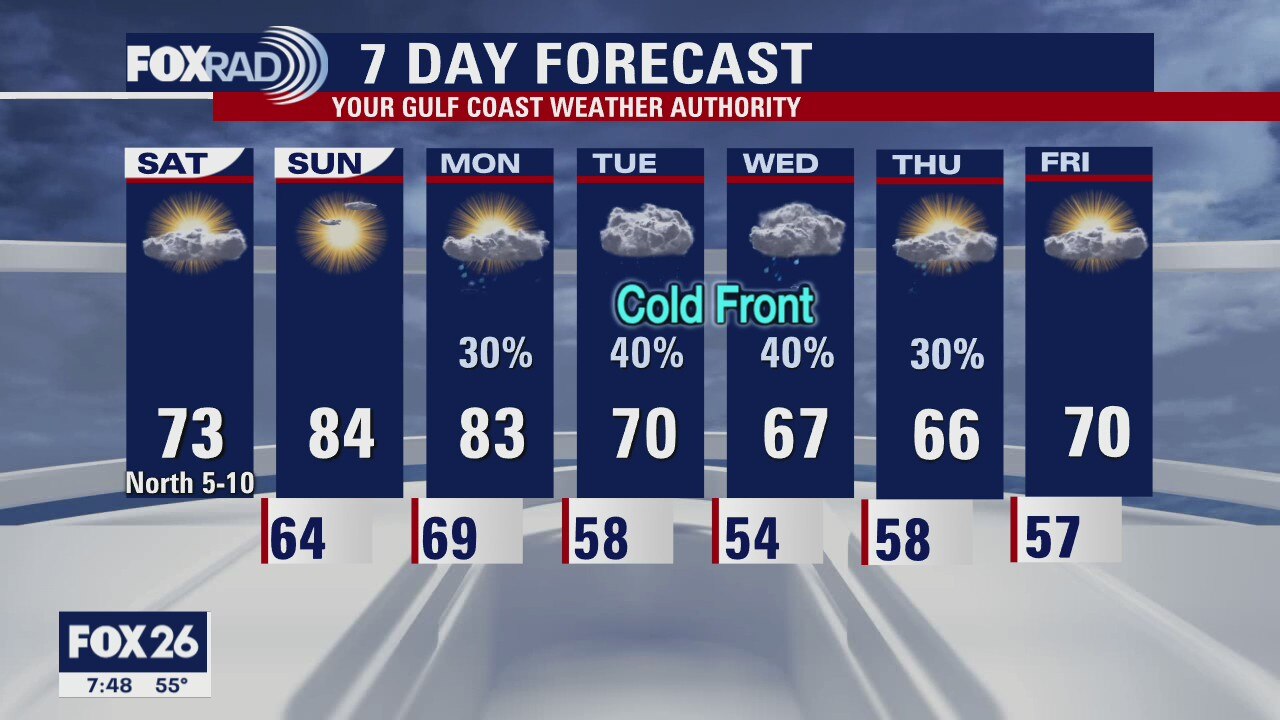
What a difference just a few hours make! We are starting the weekend much cooler than we were on Friday. Highs today will likely only reach the upper 60s and low 70s. It will be dry, but clouds are expected to linger all day. Sunday will be the day our warmer weather returns with highs likely topping out in the low 80s. Next week will bring changeable weather with a front possibly moving through on Monday. Temperatures will be cooling off as we head toward the middle part of the week with rain chances each day from Monday through Thursday.
What a difference just a few hours make! We are starting the weekend much cooler than we were on Friday. Highs today will likely only reach the upper 60s and low 70s. It will be dry, but clouds are expected to linger all day. Sunday will be the day our warmer weather returns with highs likely topping out in the low 80s. Next week will bring changeable weather with a front possibly moving through on Monday. Temperatures will be cooling off as we head toward the middle part of the week with rain chances each day from Monday through Thursday.
Saturday morning weather forecast
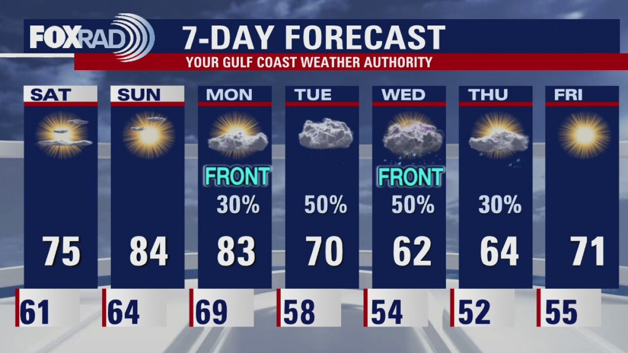
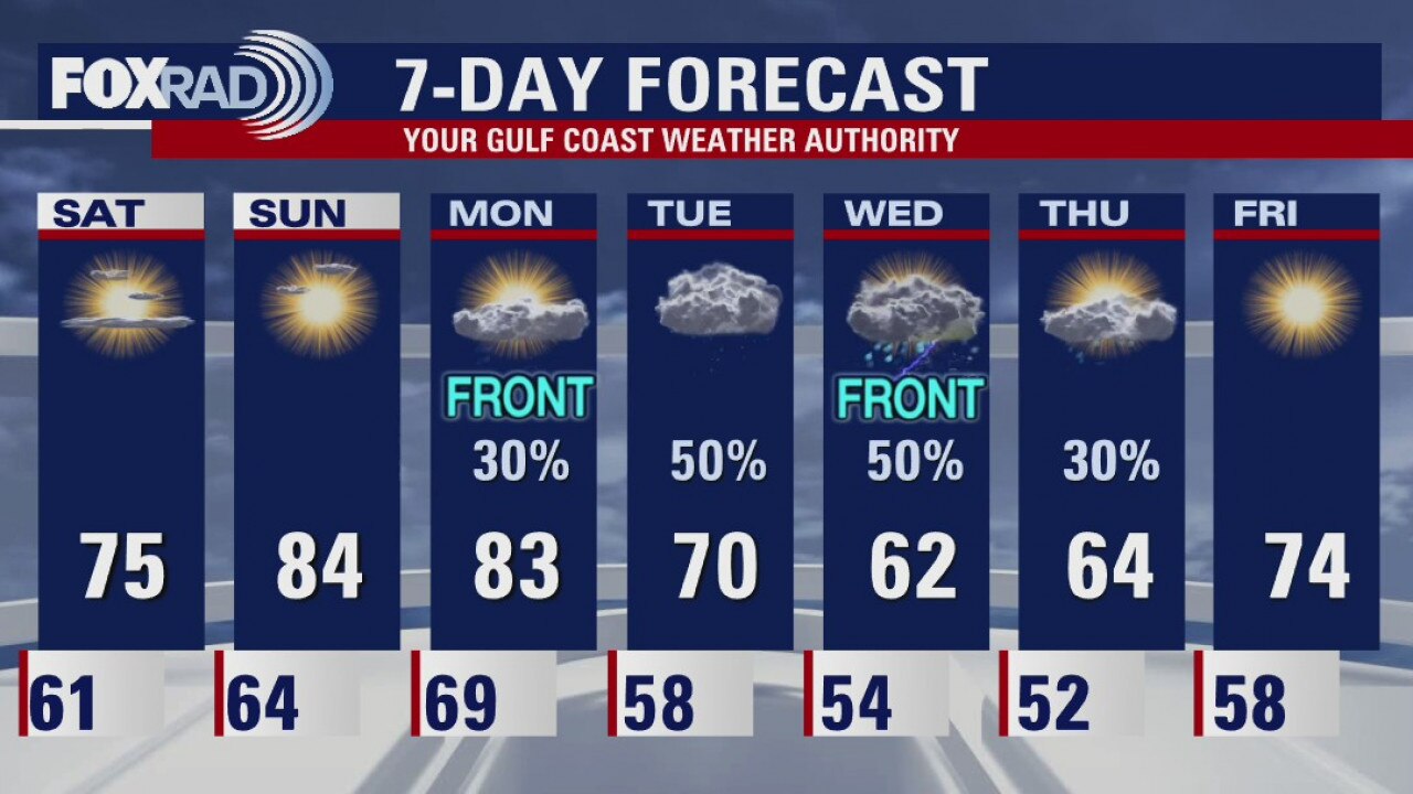
The temperatures will be cooler on Saturday thanks to the front that came through the Houston area today. Next week will have two cold fronts, one on Monday and another on Wednesday. Most of next week will be cooler and that sounds nice.
The temperatures will be cooler on Saturday thanks to the front that came through the Houston area today. Next week will have two cold fronts, one on Monday and another on Wednesday. Most of next week will be cooler and that sounds nice.
Friday evening weather forecast
The temperatures will be cooler on Saturday thanks to the front that came through the Houston area today. Next week will have two cold fronts, one on Monday and another on Wednesday. Most of next week will be cooler and that sounds nice.
The temperatures will be cooler on Saturday thanks to the front that came through the Houston area today. Next week will have two cold fronts, one on Monday and another on Wednesday. Most of next week will be cooler and that sounds nice.
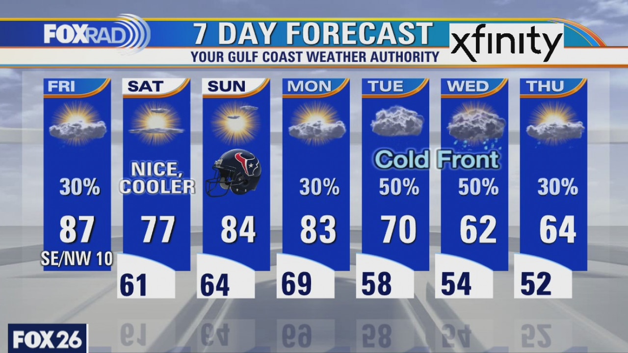
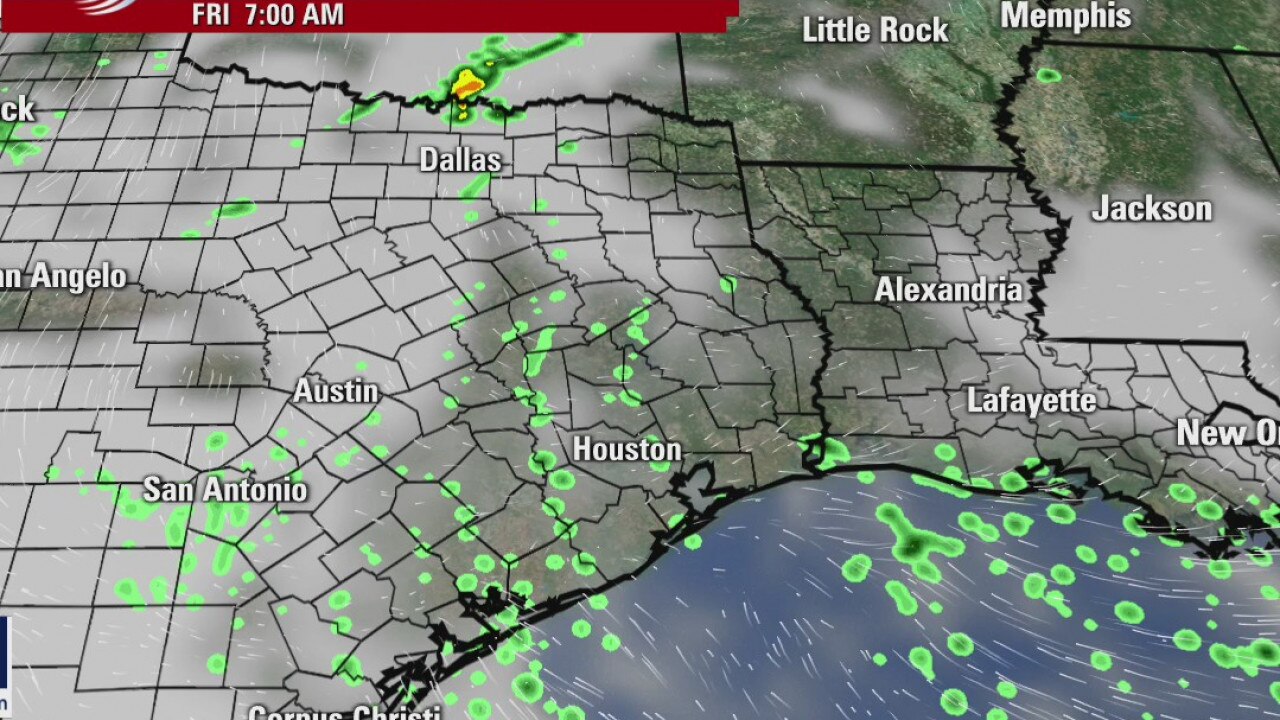
Friday weather forecast
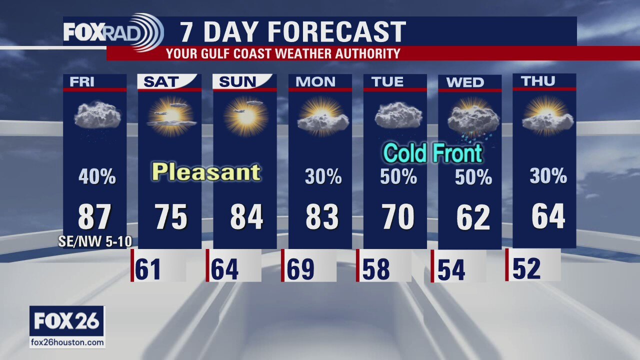
Today will be a transition day as a cool front moves in by late this afternoon. It will still be very warm, but we should see late storms followed by a nice cool down. This weekend looks great with lows back in the 60s. Next week, a stronger, rainier cold front is expected with some chilly showers Tuesday and Wednesday.
Today will be a transition day as a cool front moves in by late this afternoon. It will still be very warm, but we should see late storms followed by a nice cool down. This weekend looks great with lows back in the 60s. Next week, a stronger, rainier cold front is expected with some chilly showers Tuesday and Wednesday.
Friday weather forecast
Today will be a transition day as a cool front moves in by late this afternoon. It will still be very warm, but we should see late storms followed by a nice cool down. This weekend looks great with lows back in the 60s. Next week, a stronger, rainier cold front is expected with some chilly showers Tuesday and Wednesday.
Today will be a transition day as a cool front moves in by late this afternoon. It will still be very warm, but we should see late storms followed by a nice cool down. This weekend looks great with lows back in the 60s. Next week, a stronger, rainier cold front is expected with some chilly showers Tuesday and Wednesday.
Friday morning weather forecast
A weak front will arrive on Friday and there?s a chance for a few showers and some patchy fog. It will cool the temps a bit, but things warm up quickly by Sunday. A stronger front is expected to arrive in SE Texas around Tuesday and it will drop the temps again.
A weak front will arrive on Friday and there?s a chance for a few showers and some patchy fog. It will cool the temps a bit, but things warm up quickly by Sunday. A stronger front is expected to arrive in SE Texas around Tuesday and it will drop the temps again.
Thursday evening forecast
A weak front will arrive on Friday and there?s a chance for a few showers and some patchy fog. It will cool the temps a bit, but things warm up quickly by Sunday. A stronger front is expected to arrive in SE Texas around Tuesday and it will drop the temps again.
A weak front will arrive on Friday and there?s a chance for a few showers and some patchy fog. It will cool the temps a bit, but things warm up quickly by Sunday. A stronger front is expected to arrive in SE Texas around Tuesday and it will drop the temps again.
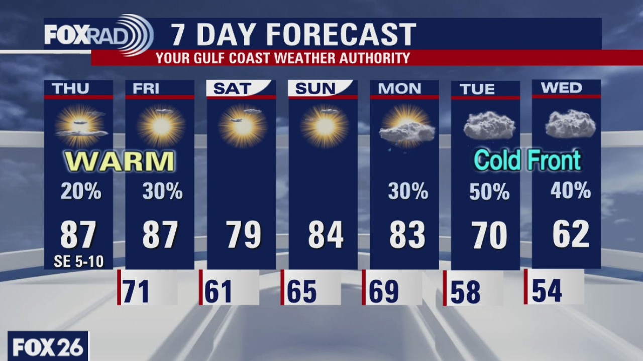
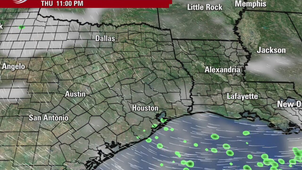
Thursday weather forecast
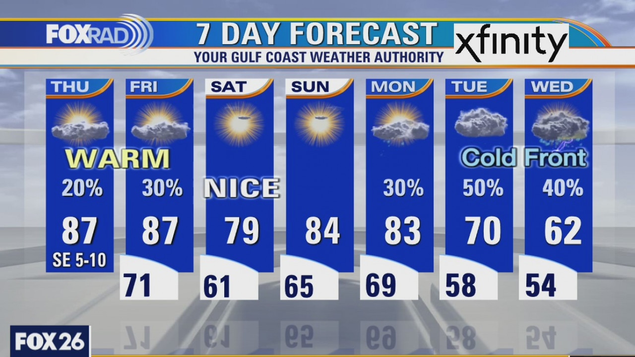
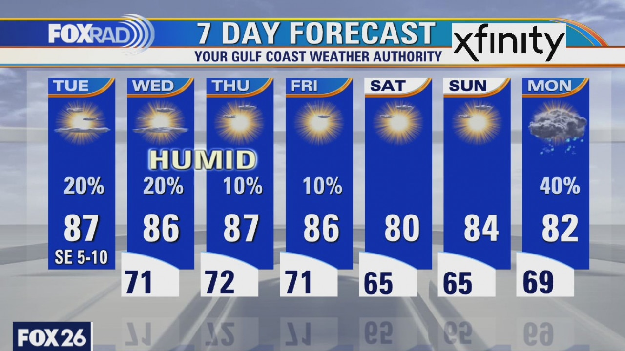
As expected, temperatures are warming nicely this afternoon. Many areas already in the low and mid 80s. We are on our way to another warm and muggy day with highs reaching the upper 80s. An isolated rain shower can't be ruled out, but tomorrow looks like we'll have a slightly better shot at seeing rain as a cold front is expected to impact the area. While that front will provide pleasant weather for the weekend, a stronger front will bring cooler weather next week with high rain chances as well.
As expected, temperatures are warming nicely this afternoon. Many areas already in the low and mid 80s. We are on our way to another warm and muggy day with highs reaching the upper 80s. An isolated rain shower can't be ruled out, but tomorrow looks like we'll have a slightly better shot at seeing rain as a cold front is expected to impact the area. While that front will provide pleasant weather for the weekend, a stronger front will bring cooler weather next week with high rain chances as well.
Thursday weather forecast
Our weather will stay much warmer than normal for today and tomorrow with a few showers today and some late day storms on Friday. A short-lived cold front should bring great weather for this weekend with a nice cool down on Saturday. Next week, models are mixed on the timing of our stronger front. By Tuesday and Wednesday, expect cooler air and some chilly rain.
Our weather will stay much warmer than normal for today and tomorrow with a few showers today and some late day storms on Friday. A short-lived cold front should bring great weather for this weekend with a nice cool down on Saturday. Next week, models are mixed on the timing of our stronger front. By Tuesday and Wednesday, expect cooler air and some chilly rain.
Thursday morning weather forecast
The weather will remain warm and humid through the weekend. Look for patchy fog Thursday morning, but it will burn off quickly. The next front looks to arrive by early Tuesday and it will knock the temps back down. It should be fun!
The weather will remain warm and humid through the weekend. Look for patchy fog Thursday morning, but it will burn off quickly. The next front looks to arrive by early Tuesday and it will knock the temps back down. It should be fun!
Wednesday Evening Weather Forecast
The weather will remain warm and humid through the weekend. Look for patchy fog Thursday morning, but it will burn off quickly. The next front looks to arrive by early Tuesday and it will knock the temps back down. It should be fun!
The weather will remain warm and humid through the weekend. Look for patchy fog Thursday morning, but it will burn off quickly. The next front looks to arrive by early Tuesday and it will knock the temps back down. It should be fun!
Wednesday weather forecast
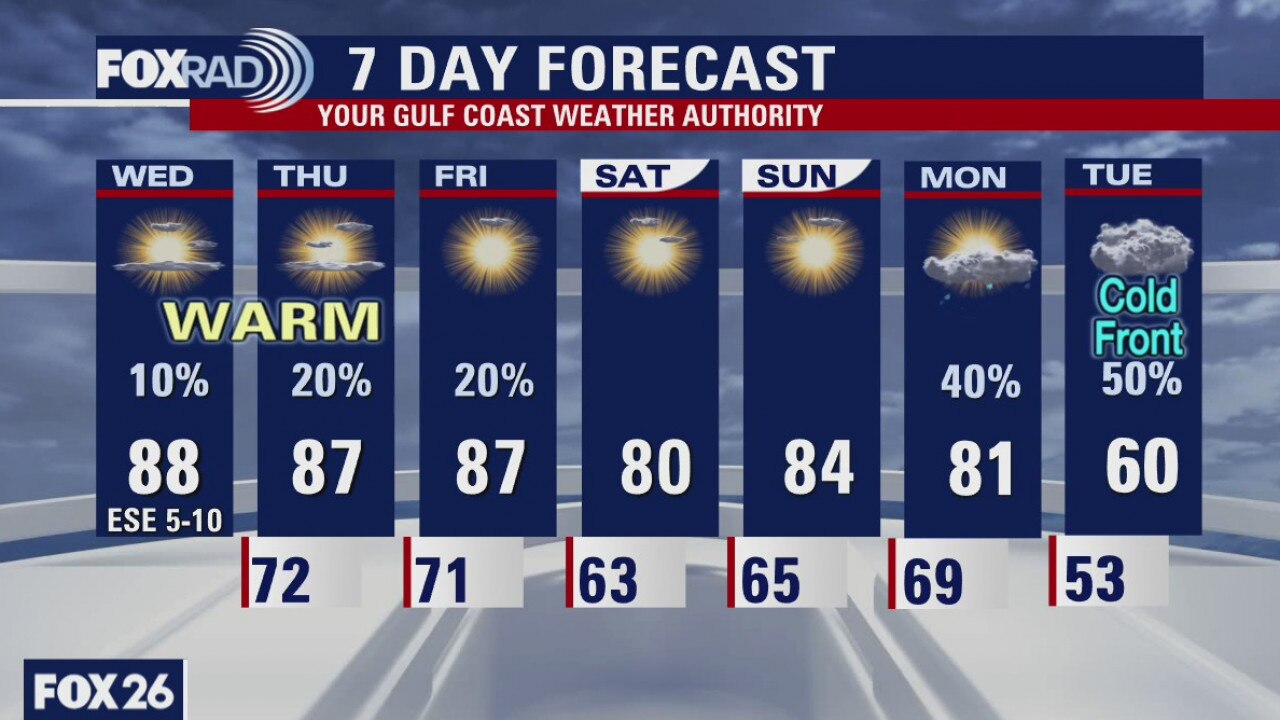
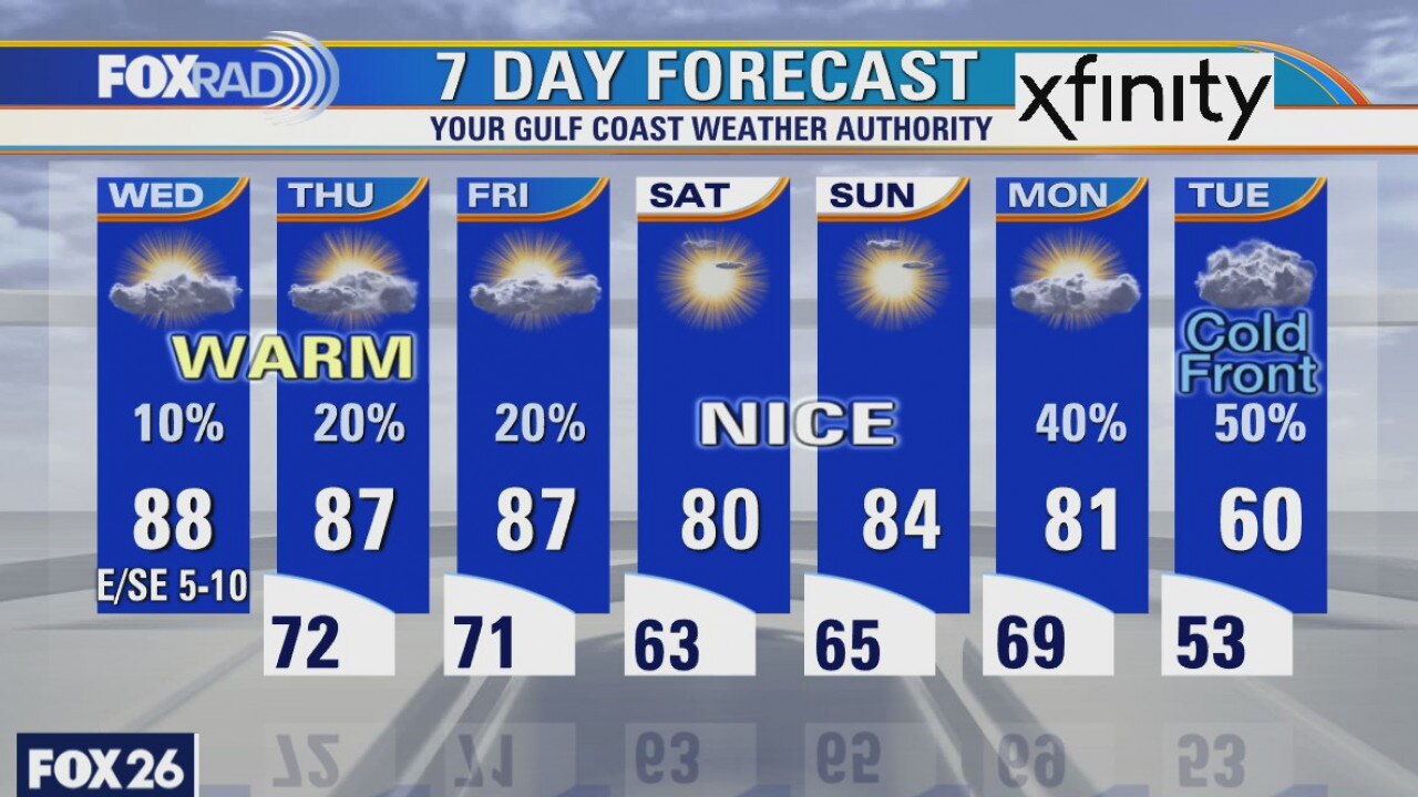
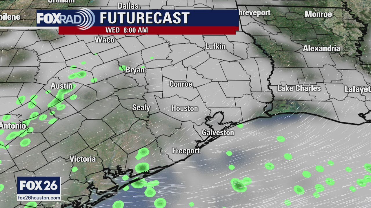
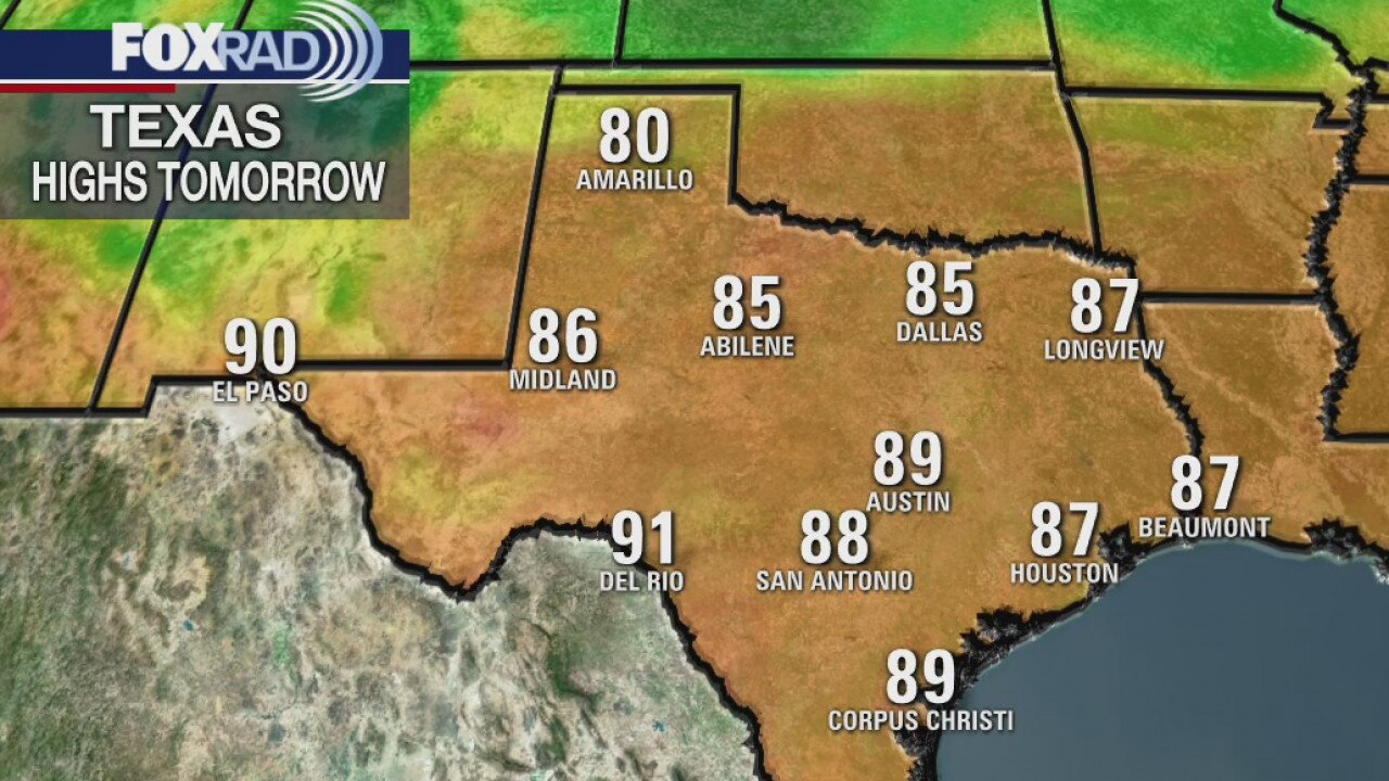
After a foggy start to our Wednesday, we've been able to warm and some areas are seeing peeks of sun. Temperatures will top out in the upper 80s with the humidity sticking around. While a stray shower can't be ruled out, it should remain dry area-wide. Similar weather is expected on Thursday and Friday ahead of a weak front that will bring clearer skies and slightly lower humidity levels for Saturday and Sunday. Big changes are on the way as we head into early next week with a strong cold front possibly moving through the area bringing much cooler air as early as Monday evening. Rain chances will also return Monday into Tuesday.
After a foggy start to our Wednesday, we've been able to warm and some areas are seeing peeks of sun. Temperatures will top out in the upper 80s with the humidity sticking around. While a stray shower can't be ruled out, it should remain dry area-wide. Similar weather is expected on Thursday and Friday ahead of a weak front that will bring clearer skies and slightly lower humidity levels for Saturday and Sunday. Big changes are on the way as we head into early next week with a strong cold front possibly moving through the area bringing much cooler air as early as Monday evening. Rain chances will also return Monday into Tuesday.
Wednesday weather forecast
Patchy areas of dense fog this morning, then partly cloudy and warm with highs in the mid to upper 80s.
Patchy areas of dense fog this morning, then partly cloudy and warm with highs in the mid to upper 80s.
Warm and humid forecast
The weather will continue to be very warm and humid for the rest of the week. There may be some patchy fog early Wednesday morning, but that will burn off to allow for plenty of sunshine in the afternoon. The next good chance for rain will come on Monday at the beginning of next week. Also, Epsilon is now a hurricane with winds at 75mph. It is not expected to threaten the USA as it will turn toward the east before the weekend.
The weather will continue to be very warm and humid for the rest of the week. There may be some patchy fog early Wednesday morning, but that will burn off to allow for plenty of sunshine in the afternoon. The next good chance for rain will come on Monday at the beginning of next week. Also, Epsilon is now a hurricane with winds at 75mph. It is not expected to threaten the USA as it will turn toward the east before the weekend.
Tuesday Evening Weather Forecast
The weather will continue to be very warm and humid for the rest of the week. There may be some patchy fog early Wednesday morning, but that will burn off to allow for plenty of sunshine in the afternoon. The next good chance for rain will come on Monday at the beginning of next week.
The weather will continue to be very warm and humid for the rest of the week. There may be some patchy fog early Wednesday morning, but that will burn off to allow for plenty of sunshine in the afternoon. The next good chance for rain will come on Monday at the beginning of next week.
Tuesday weather forecast
A pattern of above normal warmth will stay with us through Friday. Look for only isolated showers with highs in the mid to upper 80s. Patchy morning fog is possible. A brief cold front will move through early Saturday, then a much stronger front is on pace for Tuesday next week. Lows could drop into the 40s following the front.
A pattern of above normal warmth will stay with us through Friday. Look for only isolated showers with highs in the mid to upper 80s. Patchy morning fog is possible. A brief cold front will move through early Saturday, then a much stronger front is on pace for Tuesday next week. Lows could drop into the 40s following the front.
Warm and humid week
It will be warm and humid for most of the week. We can expect patchy fog in the morning hours and some sunshine in the afternoons. There isn?t much chance for a good cold front for about a week.
It will be warm and humid for most of the week. We can expect patchy fog in the morning hours and some sunshine in the afternoons. There isn?t much chance for a good cold front for about a week.
Monday weather forecast
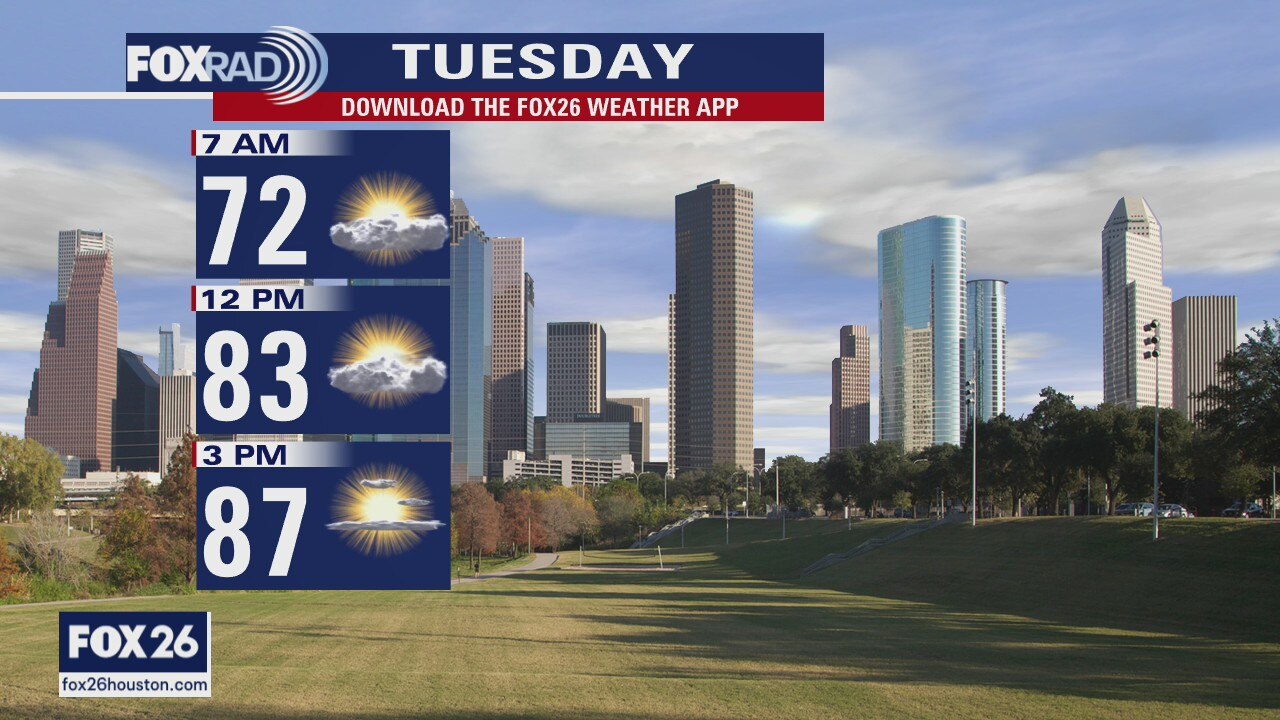
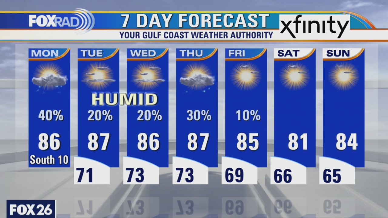
Warmer and more humid weather will return this week. Each morning, expect temperatures only in the 70s with a few patches of fog. Afternoon highs should rise into the mid 80s and a few upper 80s. Scattered showers are possible each day, with the highest chance today and only a few showers the rest of the week. A strong cold front is on the way next week.
Warmer and more humid weather will return this week. Each morning, expect temperatures only in the 70s with a few patches of fog. Afternoon highs should rise into the mid 80s and a few upper 80s. Scattered showers are possible each day, with the highest chance today and only a few showers the rest of the week. A strong cold front is on the way next week.
Monday morning weather forecast
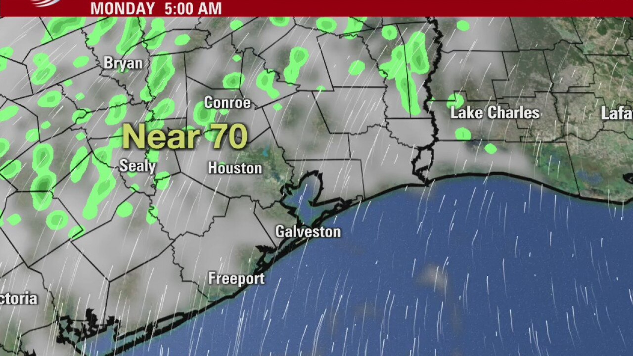
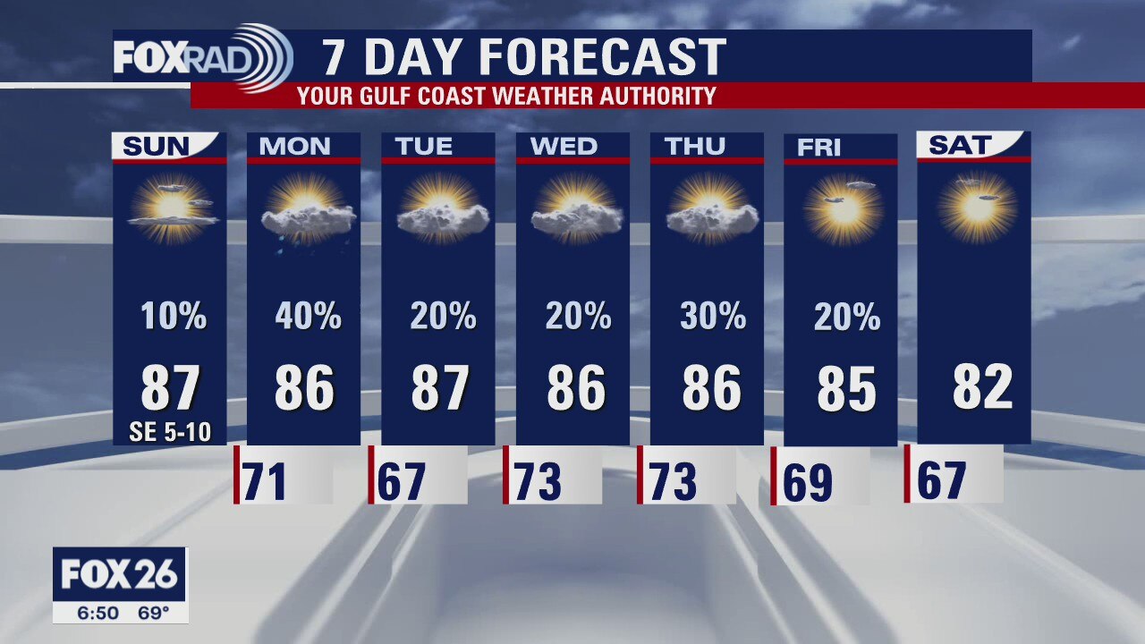
We should see a few showers around Houston on Monday. Look for a mix of sun and clouds for most of the week. There will be a chance for isolated storms and scattered showers. Most overnights in the lower 70s and highs in the upper 80s. Hopefully we'll see a stronger front again next weekend.
We should see a few showers around Houston on Monday. Look for a mix of sun and clouds for most of the week. There will be a chance for isolated storms and scattered showers. Most overnights in the lower 70s and highs in the upper 80s. Hopefully we'll see a stronger front again next weekend.
Houston-area weather forecast 10/18
A warmer start to our Sunday with many areas staying in the 70s overnight. We will warm well into the 80s today and the air will definitely feel a bit more humid. While a stray coastal shower cannot be ruled out, the majority of the area will be dry all day. As we head into Monday, however, rain chances will increase and the threat for rain will be with us all week long. This week is going to feel more like late Summer rather than Fall, but there will be plenty of dry time.
A warmer start to our Sunday with many areas staying in the 70s overnight. We will warm well into the 80s today and the air will definitely feel a bit more humid. While a stray coastal shower cannot be ruled out, the majority of the area will be dry all day. As we head into Monday, however, rain chances will increase and the threat for rain will be with us all week long. This week is going to feel more like late Summer rather than Fall, but there will be plenty of dry time.