

Saturday morning weather forecast
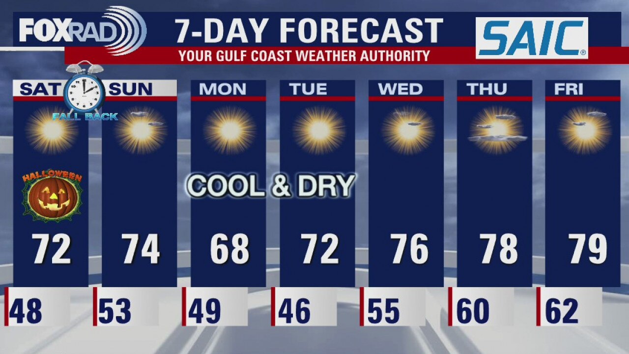
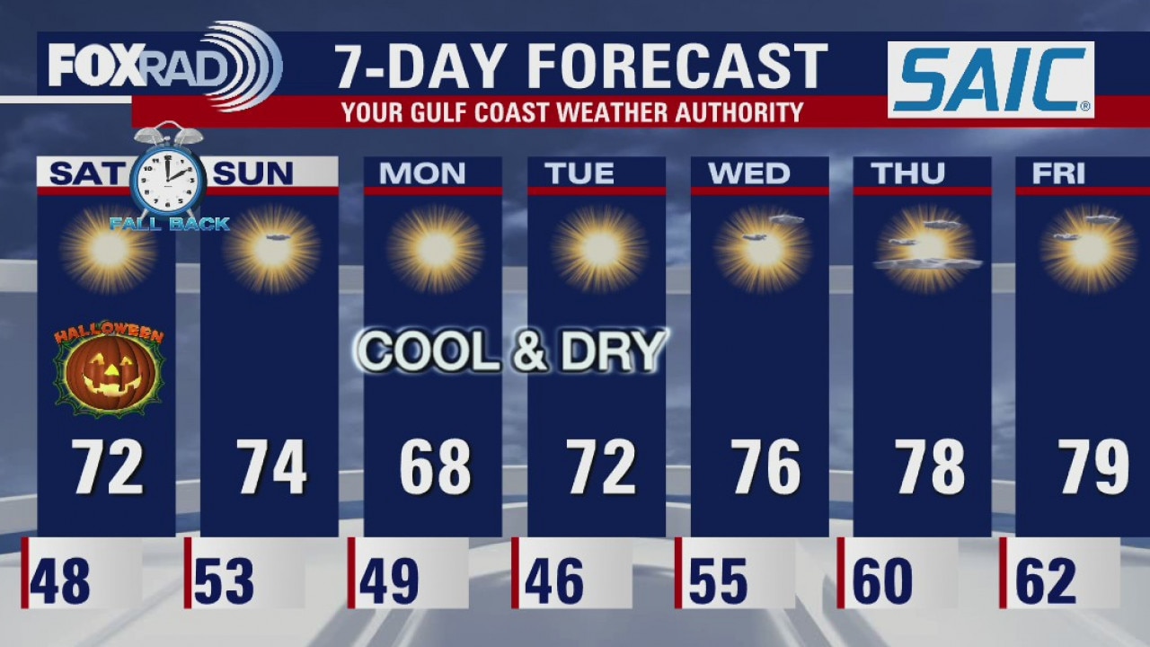
The dry and cool pattern continues for Houston. Halloween looks perfect with temps starting in the lower 70s as the sun starts to set. More rain-free days expected for most of next week.
The dry and cool pattern continues for Houston. Halloween looks perfect with temps starting in the lower 70s as the sun starts to set. More rain-free days expected for most of next week.
Friday evening weather forecast
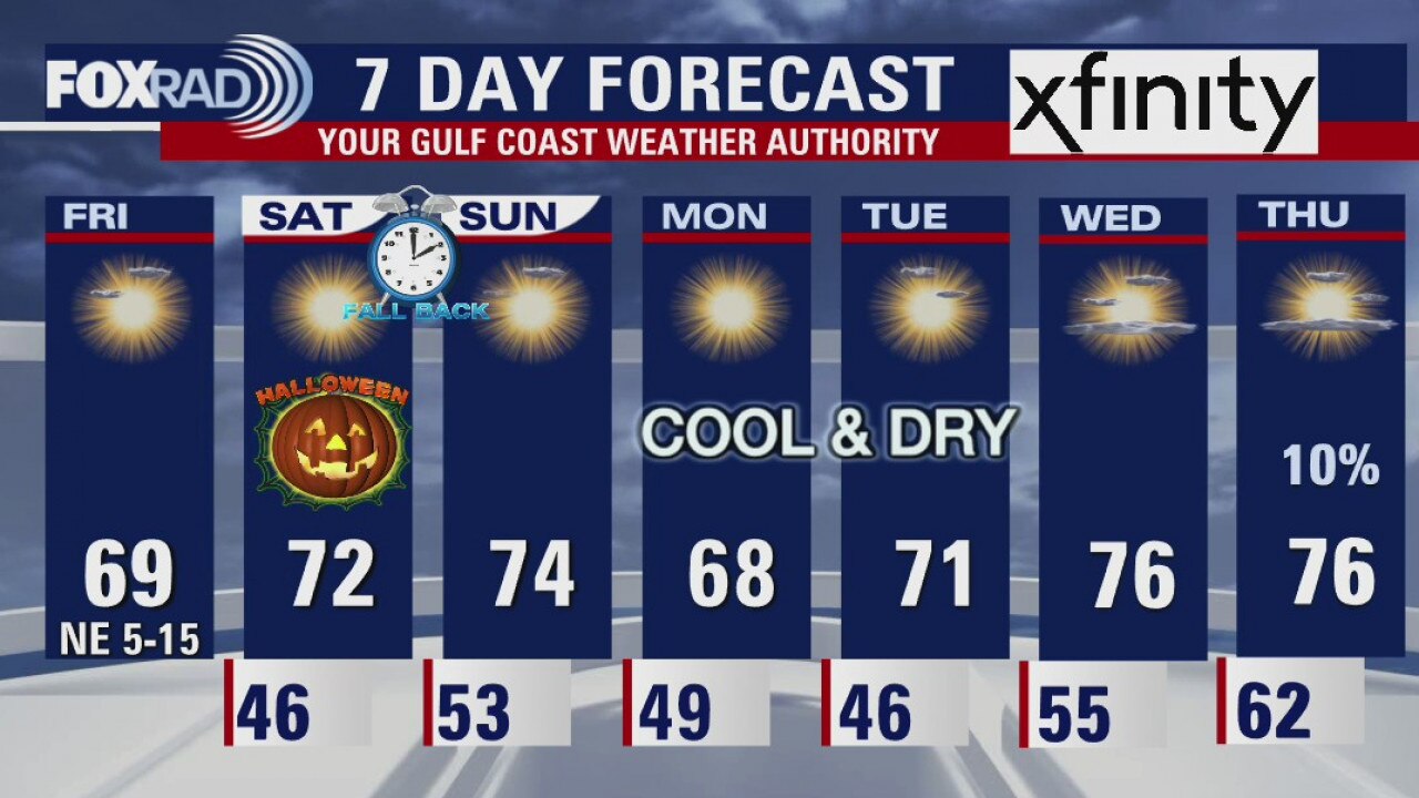
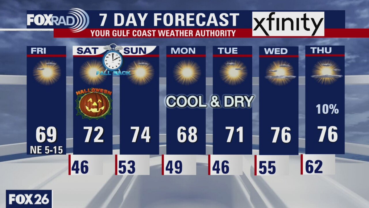
The dry and cool pattern continues for Houston. Halloween looks perfect with temps starting in the lower 70s as the sun starts to set. More rain-free days expected for most of next week.
The dry and cool pattern continues for Houston. Halloween looks perfect with temps starting in the lower 70s as the sun starts to set. More rain-free days expected for most of next week.
Friday afternoon weather update
Meteorologists Mike Iscovitz reports.
Meteorologists Mike Iscovitz reports.
Friday weather forecast
FOX 26 Meteorologist Mike Iscovitz has the latest forecast for Friday.
FOX 26 Meteorologist Mike Iscovitz has the latest forecast for Friday.
Friday weather forecast
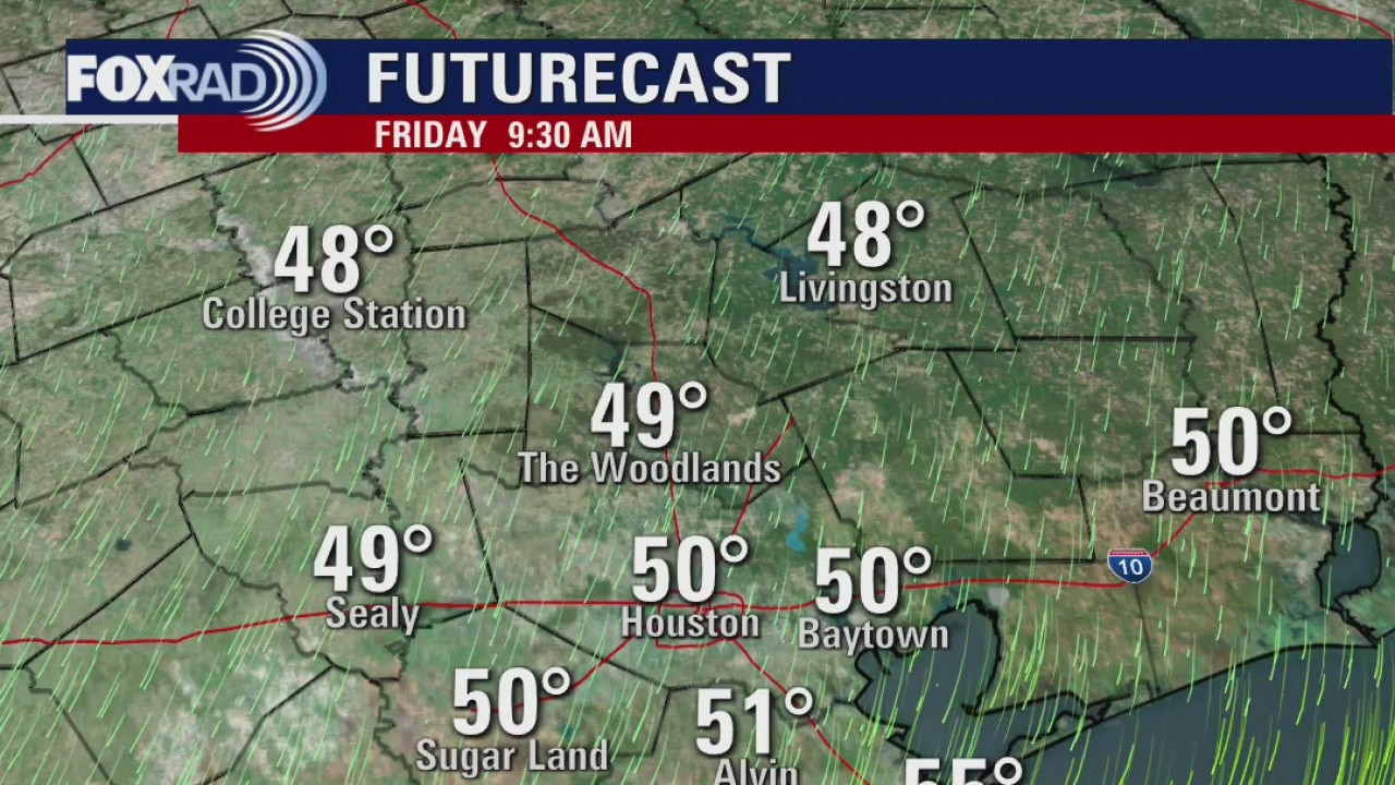
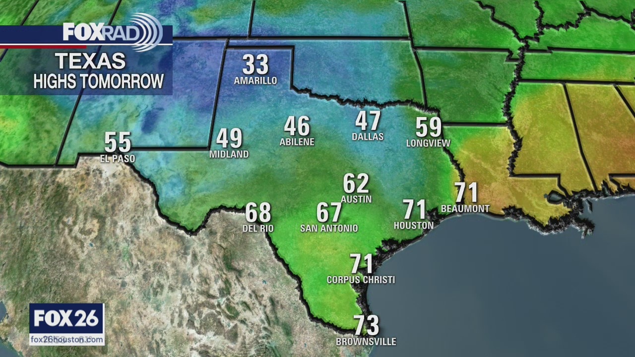
Clear and chilly this morning, then mostly sunny and dry with highs in the upper 60s.
Clear and chilly this morning, then mostly sunny and dry with highs in the upper 60s.
Friday morning weather forecast
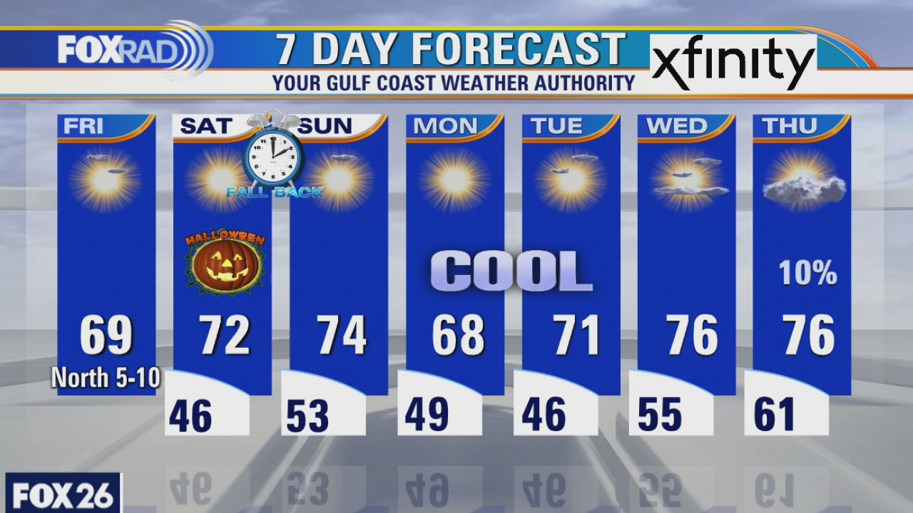
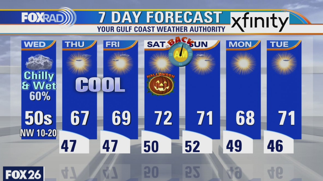
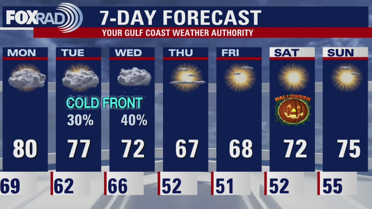
It looks cool in the mornings and mild in the afternoons for several days including the weekend. Halloween looks about perfect for an autumn holiday. I?m looking forward to the extra hour of sleep Saturday night when we turn our clocks back an hour.
It looks cool in the mornings and mild in the afternoons for several days including the weekend. Halloween looks about perfect for an autumn holiday. I?m looking forward to the extra hour of sleep Saturday night when we turn our clocks back an hour.
Thursday Evening Weather Forecast
It looks cool in the mornings and mild in the afternoons for several days including the weekend. Halloween looks about perfect for an autumn holiday. I?m looking forward to the extra hour of sleep Saturday night when we turn our clocks back an hour.
It looks cool in the mornings and mild in the afternoons for several days including the weekend. Halloween looks about perfect for an autumn holiday. I?m looking forward to the extra hour of sleep Saturday night when we turn our clocks back an hour.
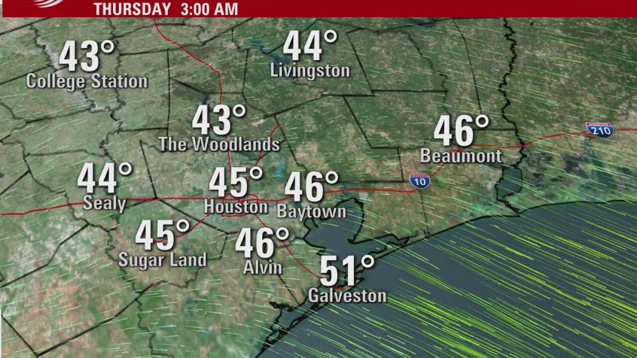
Thursday weather forecast
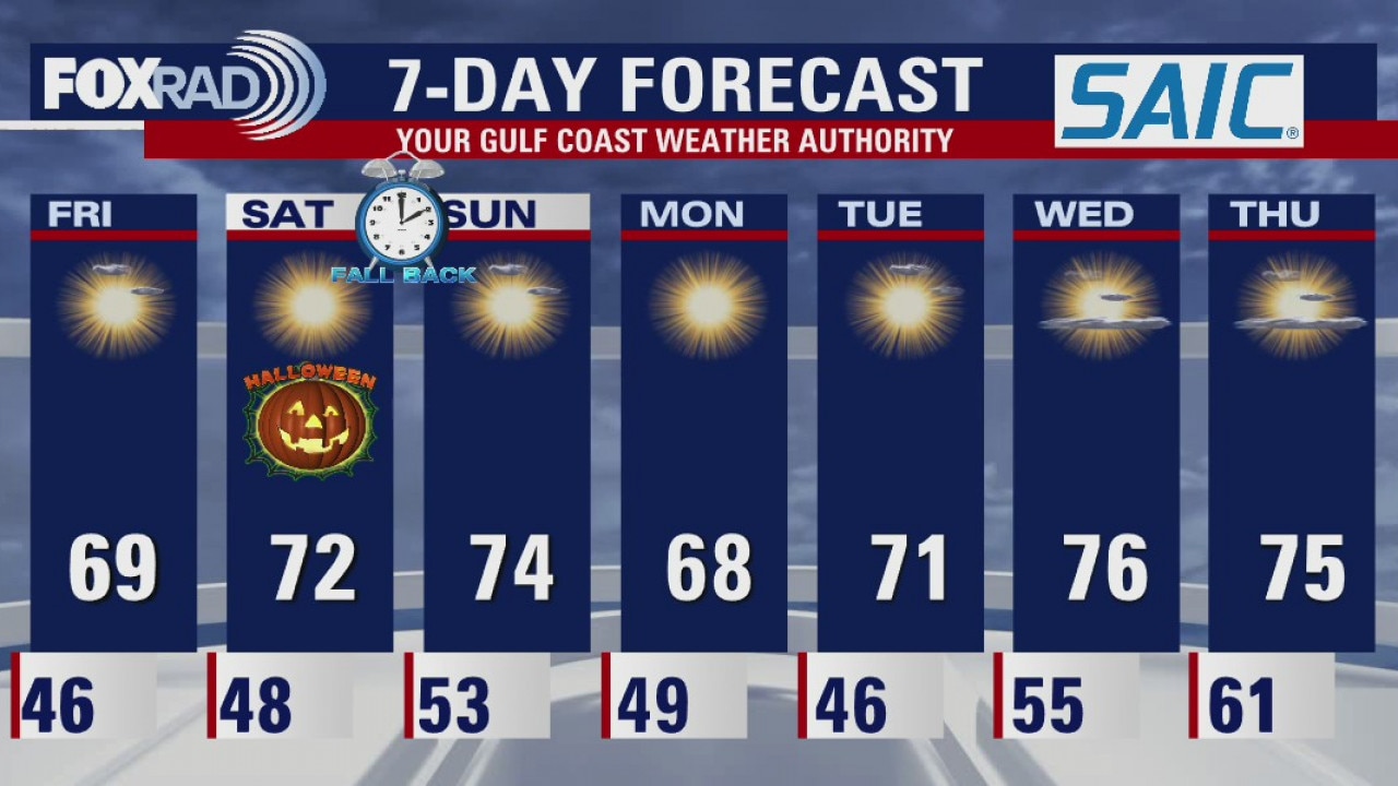
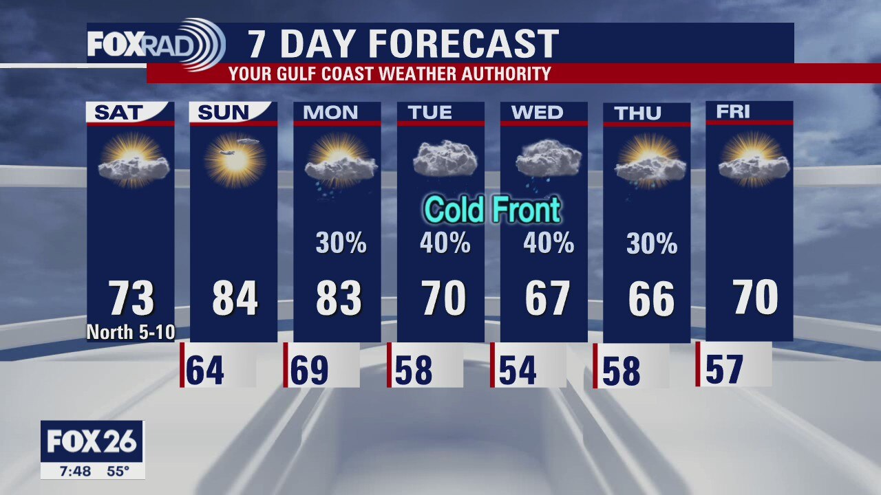
With Hurricane Zeta and a cold front now well to our east, we are at the beginning of a clear, dry and cool pattern for the next week or so. Look for a cool day today with highs in the mid 60s following by lows in the mid 40s tonight. Friday, Halloween Saturday and Sunday all look a bit milder, but still dry. This weekend marks the end of daylight saving time, so the clocks go back one hour starting at 2 a.m. Sunday.
With Hurricane Zeta and a cold front now well to our east, we are at the beginning of a clear, dry and cool pattern for the next week or so. Look for a cool day today with highs in the mid 60s following by lows in the mid 40s tonight. Friday, Halloween Saturday and Sunday all look a bit milder, but still dry. This weekend marks the end of daylight saving time, so the clocks go back one hour starting at 2 a.m. Sunday.
Thursday morning weather forecast
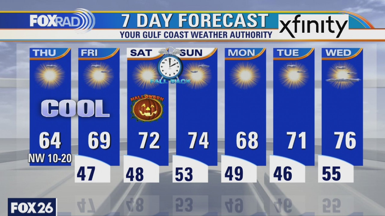
The skies will be clear and the temperatures cool for the next couple of days. It will be breezy on Thursday, which will make it feel chilly. The weekend looks very nice and our string of perfect autum-like weather will run into next week.
The skies will be clear and the temperatures cool for the next couple of days. It will be breezy on Thursday, which will make it feel chilly. The weekend looks very nice and our string of perfect autum-like weather will run into next week.
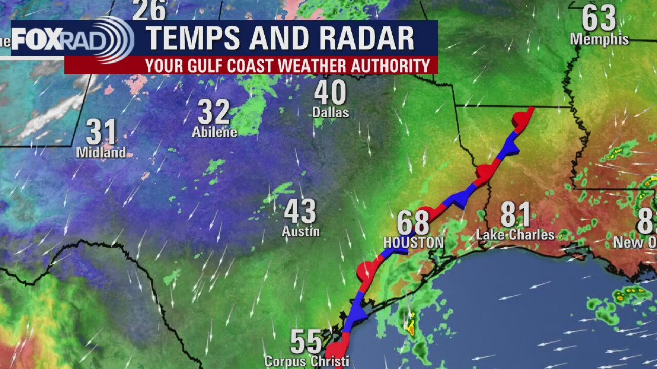
Wednesday weather forecast
Craving cold air? Had enough of the vicious mosquitoes? Well, help is here. The main issues today are wind, rain and colder air - stuck in the low 50s all day. The rest of the 7 day looks awesome with lows in the 40s and highs near 70. Louisiana and Mississippi will take a direct hit from Hurricane Zeta by this evening.
Craving cold air? Had enough of the vicious mosquitoes? Well, help is here. The main issues today are wind, rain and colder air - stuck in the low 50s all day. The rest of the 7 day looks awesome with lows in the 40s and highs near 70. Louisiana and Mississippi will take a direct hit from Hurricane Zeta by this evening.
Another cold front on the way...
Another cold front arrives on Wednesday and it will drop the temperatures for a few days. The skies will clear on Thursday and stay that way through Halloween. Lows will drop into the 40s. Hurricane Zeta won?t have much of an impact on southeast Texas except for some elevated tides.
Another cold front arrives on Wednesday and it will drop the temperatures for a few days. The skies will clear on Thursday and stay that way through Halloween. Lows will drop into the 40s. Hurricane Zeta won?t have much of an impact on southeast Texas except for some elevated tides.
Tuesday Evening Weather Forecast
Zeta is currently a tropical storm, but it?s expected to become a hurricane again. The cone is very small as confidence is high that it will make landfall near SE Louisiana. Elevated tides are the only impacts SE Texas could get from the storm.
Zeta is currently a tropical storm, but it?s expected to become a hurricane again. The cone is very small as confidence is high that it will make landfall near SE Louisiana. Elevated tides are the only impacts SE Texas could get from the storm.
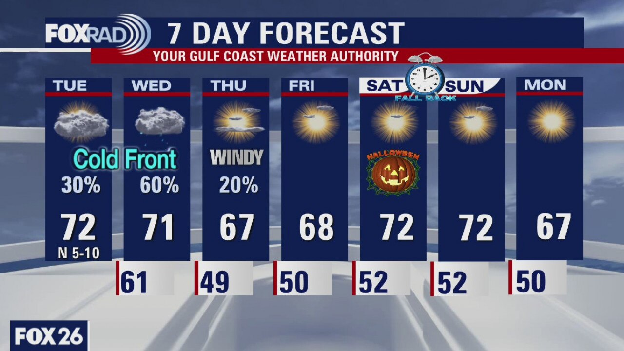
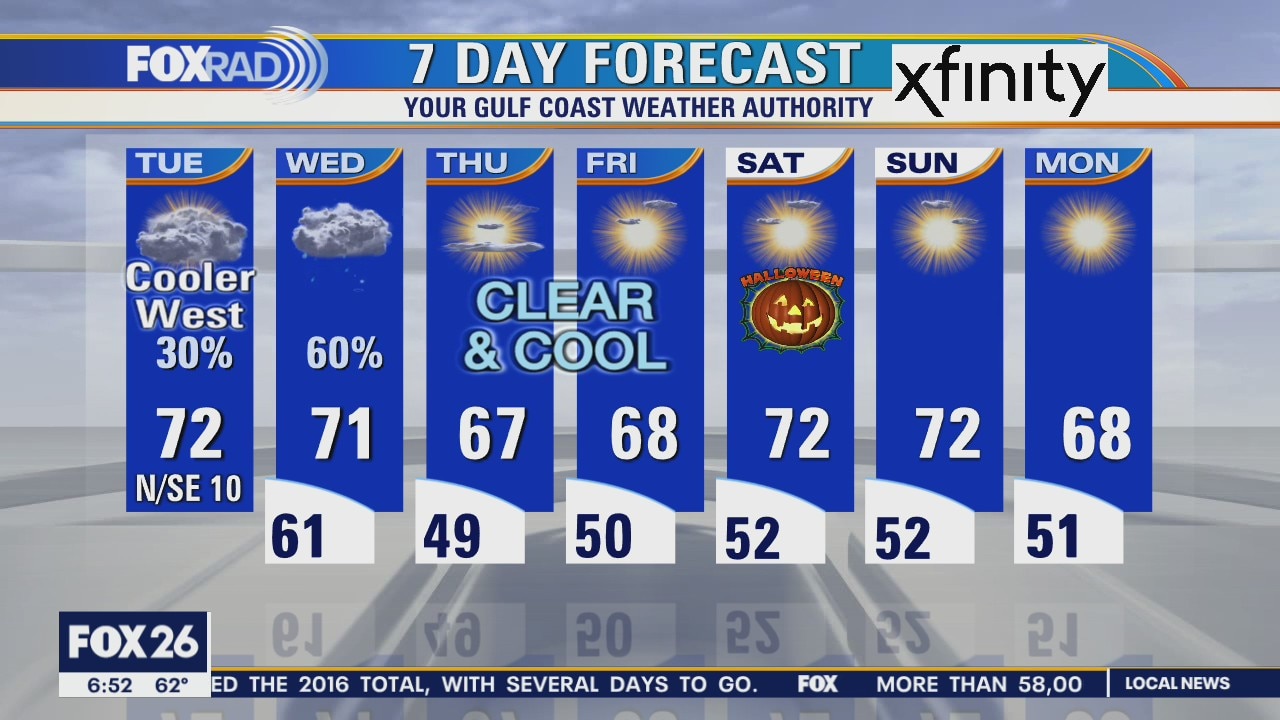
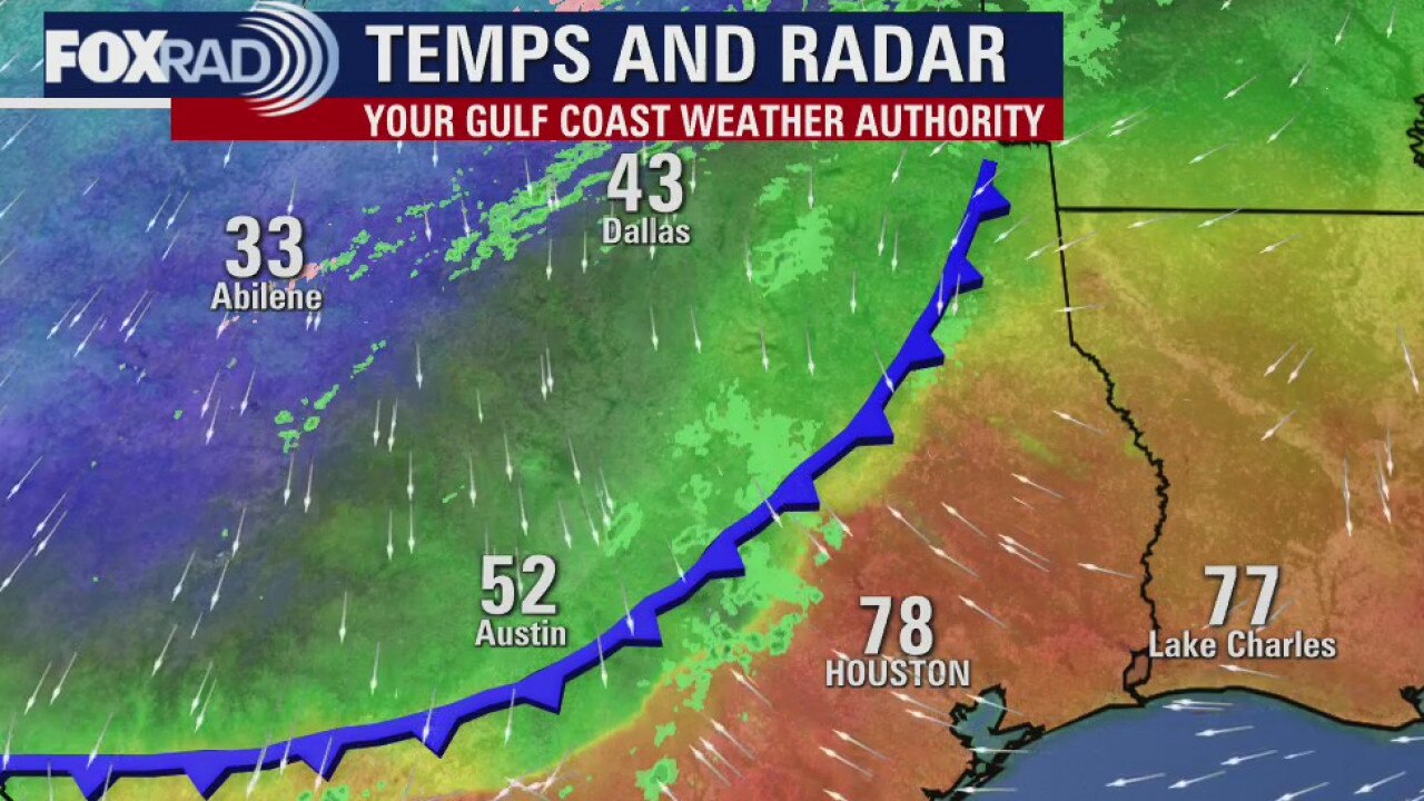
Tuesday weather forecast
Today is an unusual one with chilly air west of Houston and muggy air along the coast, so with highs in the low 70s in Houston, expect 50s and 60s out west. A front will sweep through here tomorrow bringing cooler air and eventual clearing. Thursday through this week will be clear and chilly with lows in the 40s and 50s and highs near 70. Hurricane Zeta will pass well east of our area late Wednesday with the only effect here being waves and minor coastal flooding tomorrow.
Today is an unusual one with chilly air west of Houston and muggy air along the coast, so with highs in the low 70s in Houston, expect 50s and 60s out west. A front will sweep through here tomorrow bringing cooler air and eventual clearing. Thursday through this week will be clear and chilly with lows in the 40s and 50s and highs near 70. Hurricane Zeta will pass well east of our area late Wednesday with the only effect here being waves and minor coastal flooding tomorrow.
Monday Evening Weather Forecast
We will have cooler weather for the rest of the week as two fronts arrive. The stronger front will arrive mid-week to bring a real chill in the air. The weather looks nice for Halloween on Saturday with clear skies and mild to cool temperatures.
We will have cooler weather for the rest of the week as two fronts arrive. The stronger front will arrive mid-week to bring a real chill in the air. The weather looks nice for Halloween on Saturday with clear skies and mild to cool temperatures.
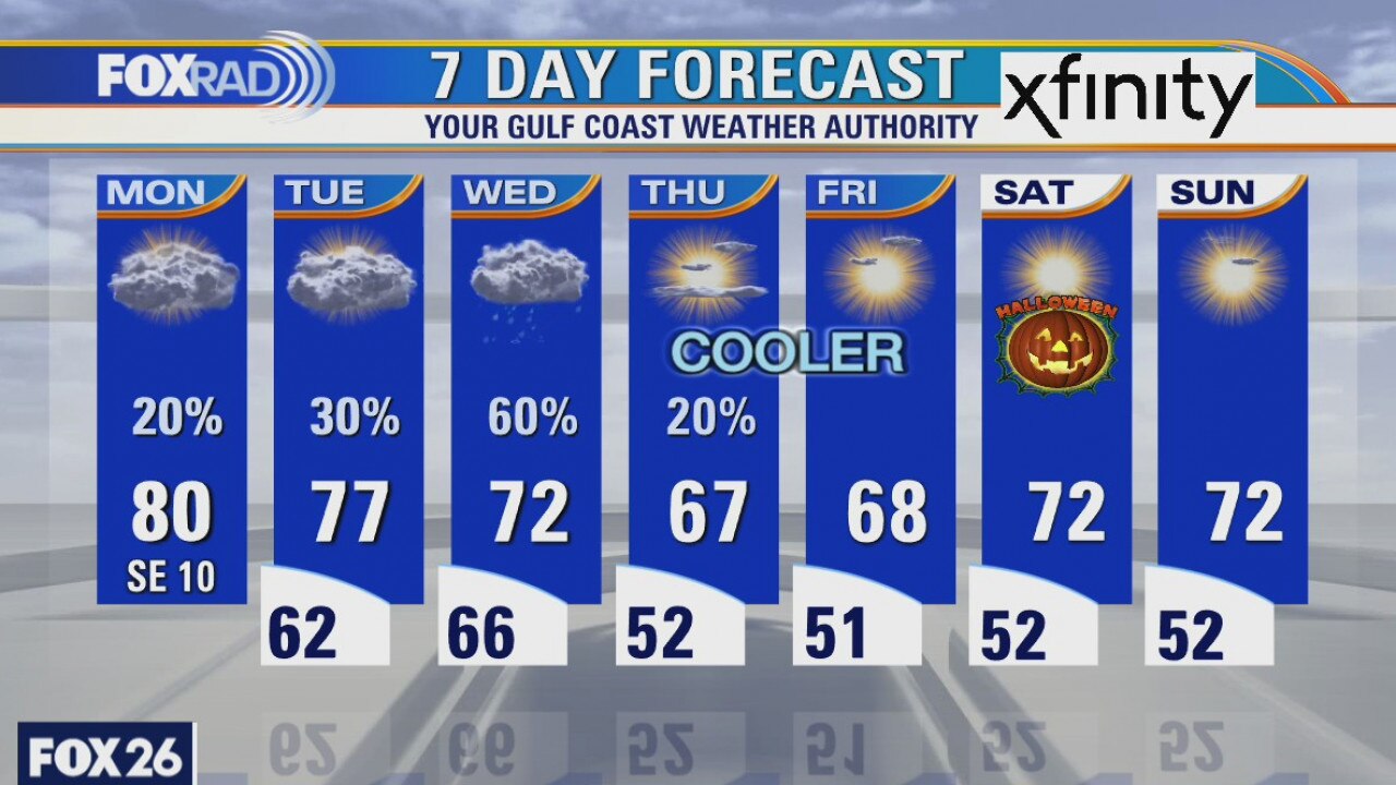
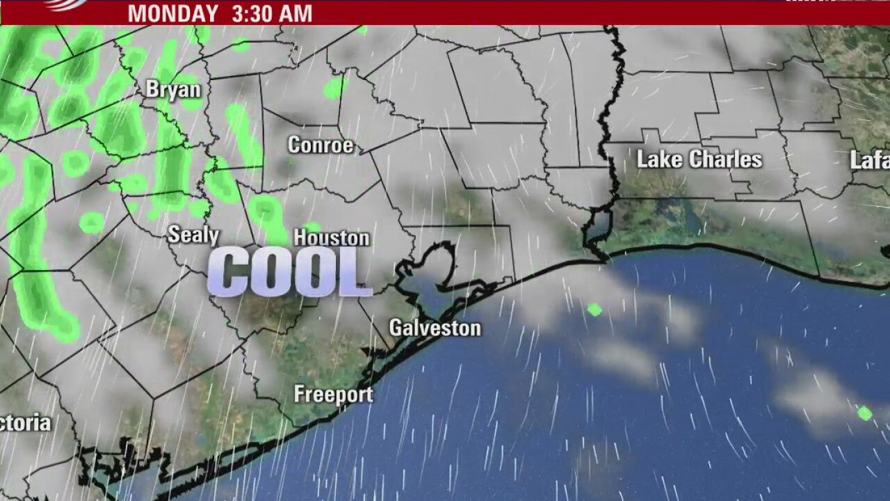
Monday weather forecast
It?s going to be a very interesting and unusual week across the Gulf Coast and Texas. The season?s 27th named storm, Zeta, will approach Texas, then move east toward Louisiana on Wednesday while freezing temperatures, ice and some snow will affect NW Texas. Locally, look for isolated shower with upper 80s today, slightly cooler weather tomorrow, then cooler and wet weather on Wednesday. We will end the week with lows in the 40s and 50s.
It?s going to be a very interesting and unusual week across the Gulf Coast and Texas. The season?s 27th named storm, Zeta, will approach Texas, then move east toward Louisiana on Wednesday while freezing temperatures, ice and some snow will affect NW Texas. Locally, look for isolated shower with upper 80s today, slightly cooler weather tomorrow, then cooler and wet weather on Wednesday. We will end the week with lows in the 40s and 50s.
Monday morning weather forecast
Look for a mostly cloudy and breezy day on Monday with mild temperatures. A cold front stalls across Southeast Texas on Tuesday and should give us some rain chances for a couple days. Another push of cool/dry air for the end of the week should set us up for several days of pleasant Fall weather, including the weekend!
Look for a mostly cloudy and breezy day on Monday with mild temperatures. A cold front stalls across Southeast Texas on Tuesday and should give us some rain chances for a couple days. Another push of cool/dry air for the end of the week should set us up for several days of pleasant Fall weather, including the weekend!
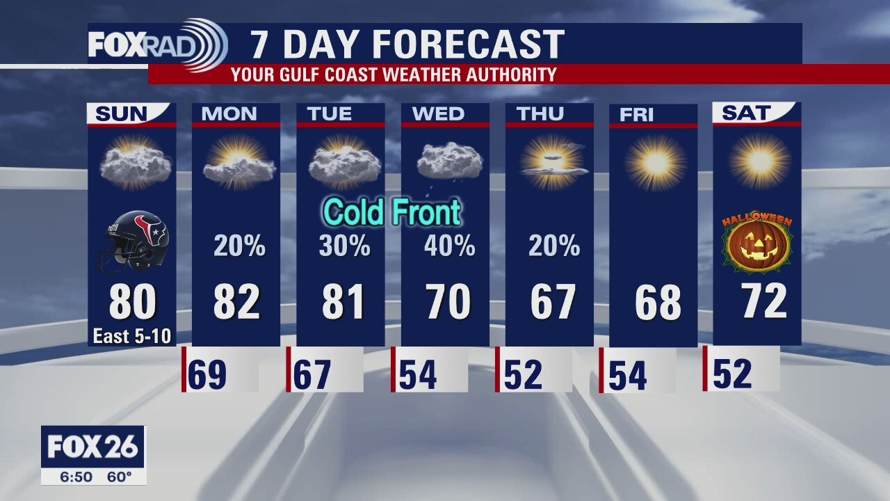
Houston-area weather forecast 10/25
Sunday is setting up to be a warmer day than Saturday, but temperatures won't be as warm as Friday due to clouds in the area. It will be dry all day, but the thicker cloud cover will help keep temperatures in the upper 70s and low 80s. Our attention then shifts to tropical storm Zeta, expected to make landfall between Louisiana and Florida late Wednesday or Thursday. While some uncertainty remains, Zeta should remain east of Texas. Meanwhile, a cold front will dive south and try to push through the region on Tuesday or Wednesday. Cooler temperatures expected to arrive by Thursday or Friday.
Sunday is setting up to be a warmer day than Saturday, but temperatures won't be as warm as Friday due to clouds in the area. It will be dry all day, but the thicker cloud cover will help keep temperatures in the upper 70s and low 80s. Our attention then shifts to tropical storm Zeta, expected to make landfall between Louisiana and Florida late Wednesday or Thursday. While some uncertainty remains, Zeta should remain east of Texas. Meanwhile, a cold front will dive south and try to push through the region on Tuesday or Wednesday. Cooler temperatures expected to arrive by Thursday or Friday.
Sunday morning weather forecast
Sunday will be another beautiful day around Houston, it will be warmer than Saturday but not too bad. We are expecting 2 fronts this week and both should bring some rain with them when they arrive. But for now, its looking to be another stellar weekend waiting for us after the work week.
Sunday will be another beautiful day around Houston, it will be warmer than Saturday but not too bad. We are expecting 2 fronts this week and both should bring some rain with them when they arrive. But for now, its looking to be another stellar weekend waiting for us after the work week.
Houston-area weather forecast 10/24
What a difference just a few hours make! We are starting the weekend much cooler than we were on Friday. Highs today will likely only reach the upper 60s and low 70s. It will be dry, but clouds are expected to linger all day. Sunday will be the day our warmer weather returns with highs likely topping out in the low 80s. Next week will bring changeable weather with a front possibly moving through on Monday. Temperatures will be cooling off as we head toward the middle part of the week with rain chances each day from Monday through Thursday.
What a difference just a few hours make! We are starting the weekend much cooler than we were on Friday. Highs today will likely only reach the upper 60s and low 70s. It will be dry, but clouds are expected to linger all day. Sunday will be the day our warmer weather returns with highs likely topping out in the low 80s. Next week will bring changeable weather with a front possibly moving through on Monday. Temperatures will be cooling off as we head toward the middle part of the week with rain chances each day from Monday through Thursday.