

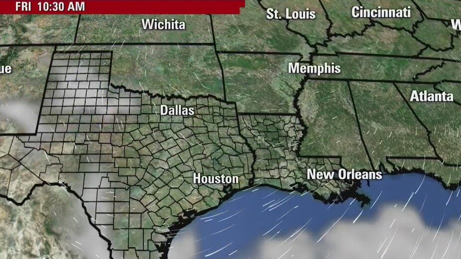
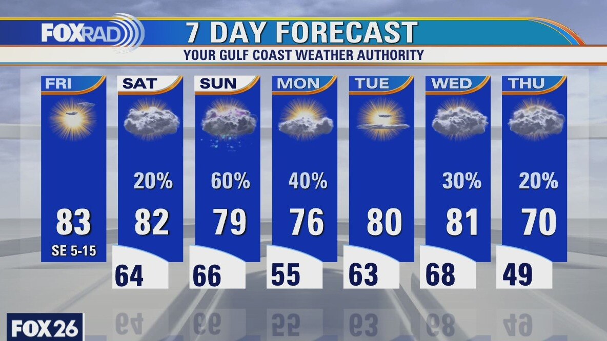
Friday morning weather forecast
Conditions will cool this evening and the winds will turn from the north and be breezy. It will be chilly over the next couple of mornings with lows mostly dipping into the 40s. There will be plenty of sunshine during the day, but highs will only reach the upper 60s and low 70s until Easter Sunday. A few light showers are possible on Sunday, but nothing too soggy for Easter Egg hunts.
Conditions will cool this evening and the winds will turn from the north and be breezy. It will be chilly over the next couple of mornings with lows mostly dipping into the 40s. There will be plenty of sunshine during the day, but highs will only reach the upper 60s and low 70s until Easter Sunday. A few light showers are possible on Sunday, but nothing too soggy for Easter Egg hunts.
Thursday evening weather forecast
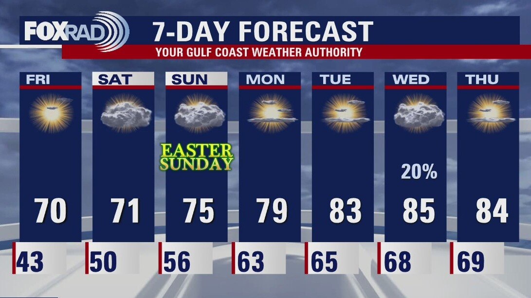
Friday will start off rather cool with lows mainly in the 40s. The afternoon looks nice with highs reaching the 70s. Easter Weekend looks alright. It will be more cloudy and a stray drop of rain is not out of the question, but isn't likely. The coming week looks a little warmer with high temps heading back into the 80s.
Friday will start off rather cool with lows mainly in the 40s. The afternoon looks nice with highs reaching the 70s. Easter Weekend looks alright. It will be more cloudy and a stray drop of rain is not out of the question, but isn't likely. The coming week looks a little warmer with high temps heading back into the 80s.
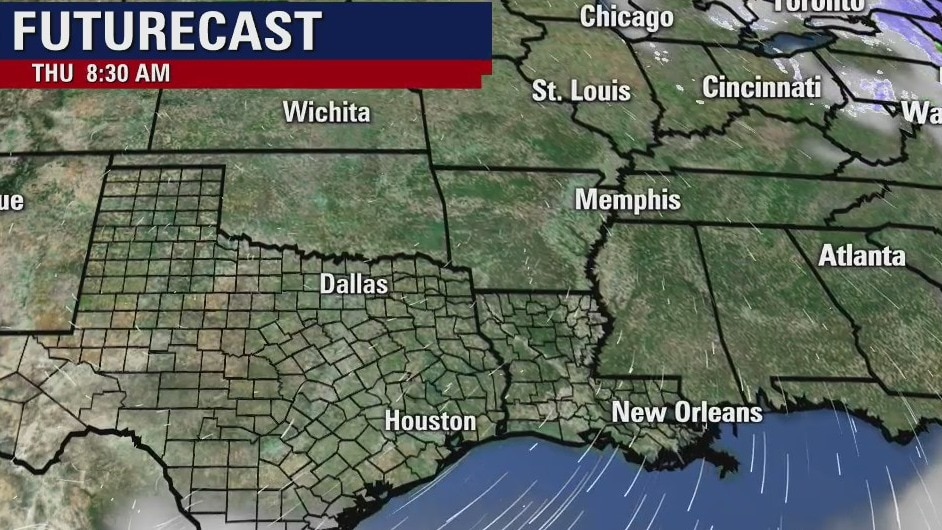
Thursday weather forecast
Following morning lows in the 40s, we should have plenty of sunshine today with very dry air and highs in the upper 60s and low 70s. Good Friday will begin with a chilly morning, then highs in the upper 60s. Watch for a few Easter Sunday showers and much warmer air next week.
Following morning lows in the 40s, we should have plenty of sunshine today with very dry air and highs in the upper 60s and low 70s. Good Friday will begin with a chilly morning, then highs in the upper 60s. Watch for a few Easter Sunday showers and much warmer air next week.
Thursday morning weather forecast
Conditions will cool this evening and the winds will turn from the north and be breezy. It will be chilly over the next couple of mornings with lows mostly dipping into the 40s. There will be plenty of sunshine during the day, but highs will only reach the upper 60s and low 70s until Easter Sunday. A few light showers are possible on Sunday, but nothing too soggy for Easter Egg hunts.
Conditions will cool this evening and the winds will turn from the north and be breezy. It will be chilly over the next couple of mornings with lows mostly dipping into the 40s. There will be plenty of sunshine during the day, but highs will only reach the upper 60s and low 70s until Easter Sunday. A few light showers are possible on Sunday, but nothing too soggy for Easter Egg hunts.
Wednesday evening weather forecast
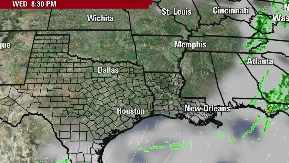
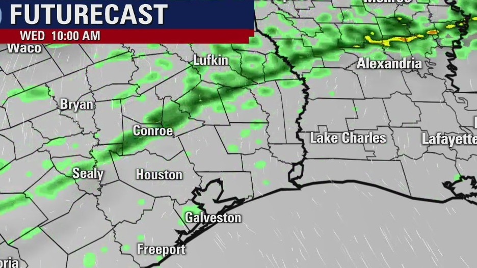
Conditions will cool this evening and the winds will turn from the north and be breezy. It will be chilly over the next couple of mornings with lows mostly dipping into the 40s. There will be plenty of sunshine during the day, but highs will only reach the upper 60s and low 70s until Easter Sunday. A few light showers are possible on Sunday, but nothing too soggy for Easter Egg hunts.
Conditions will cool this evening and the winds will turn from the north and be breezy. It will be chilly over the next couple of mornings with lows mostly dipping into the 40s. There will be plenty of sunshine during the day, but highs will only reach the upper 60s and low 70s until Easter Sunday. A few light showers are possible on Sunday, but nothing too soggy for Easter Egg hunts.
Wednesday weather forecast
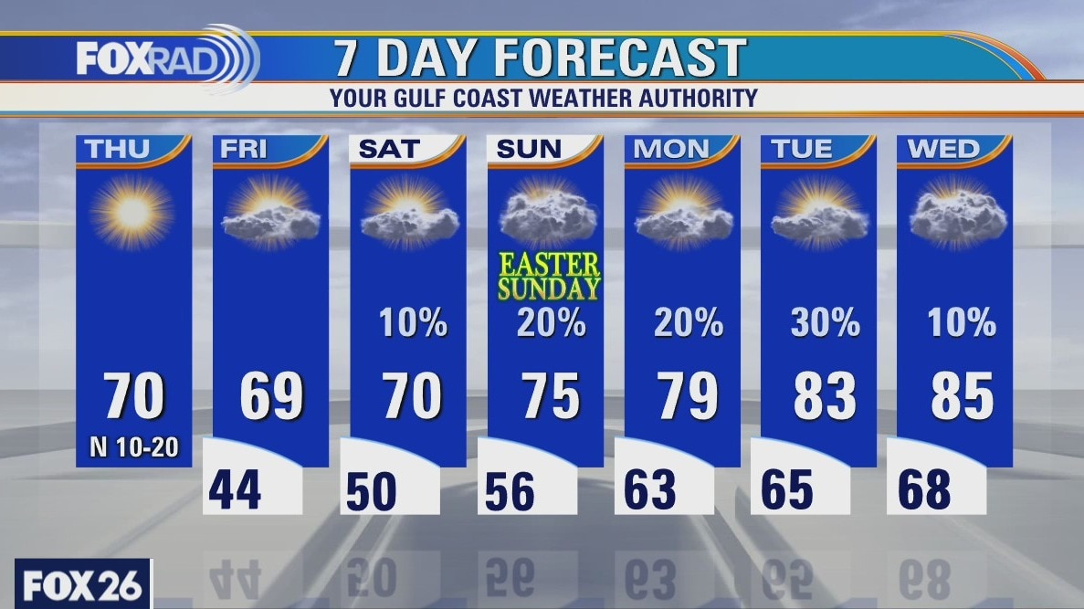
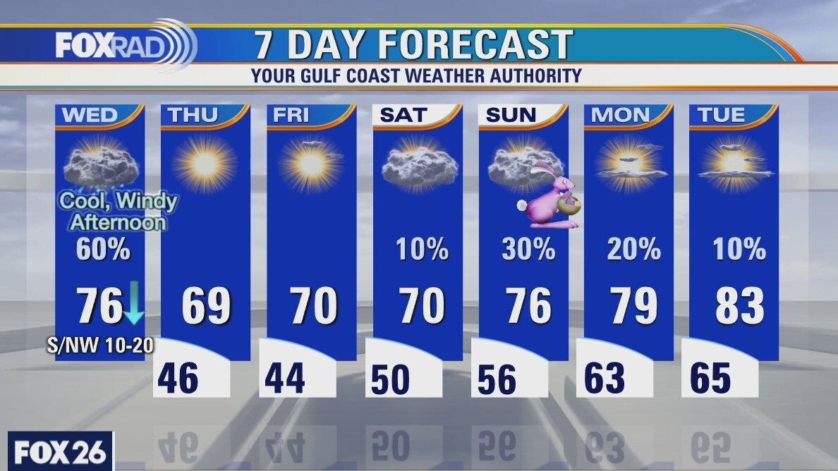
Don't get caught off guard. Today's weather will be very active with warm, humid morning conditions giving way to a line of storms, then windy and much cooler air. Look for afternoon temps to fall into the 50s with gusty north winds. Thursday and Friday look great with chilly mornings and sunny days. I had to bump up the rain chance on Easter just a little based on the newest models.
Don't get caught off guard. Today's weather will be very active with warm, humid morning conditions giving way to a line of storms, then windy and much cooler air. Look for afternoon temps to fall into the 50s with gusty north winds. Thursday and Friday look great with chilly mornings and sunny days. I had to bump up the rain chance on Easter just a little based on the newest models.

Tuesday evening weather forecast
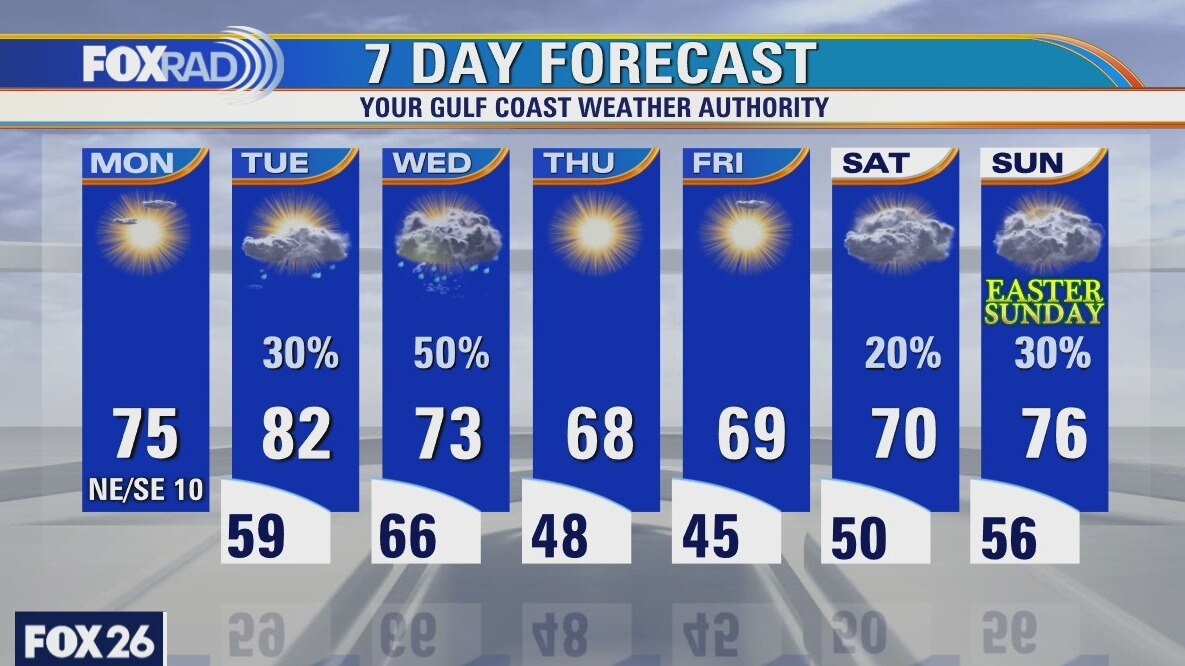
Showers will be likely on Wed. as a strong cold front arrives. Temps will reach the 70s in the morning, but will drop during the day as the cooler air moves in. Lows will be in the 40s for a couple of days, so we will especially feel the chilly air in the morning hours. Highs will only be in the upper 60s to low 70s until the end of the week.
Showers will be likely on Wed. as a strong cold front arrives. Temps will reach the 70s in the morning, but will drop during the day as the cooler air moves in. Lows will be in the 40s for a couple of days, so we will especially feel the chilly air in the morning hours. Highs will only be in the upper 60s to low 70s until the end of the week.

Tuesday weather forecast
Temps are about 20 degrees warmer this morning courtesy of breezy south winds. Humidity will return today bringing a few scattered showers with highs in the 80s. A cold front should bring a few storms tomorrow followed by cooler and drier air for the end of this week.
Temps are about 20 degrees warmer this morning courtesy of breezy south winds. Humidity will return today bringing a few scattered showers with highs in the 80s. A cold front should bring a few storms tomorrow followed by cooler and drier air for the end of this week.
Tuesday morning weather forecast
The temps will remain warm until Wed. when a cold front arrives. Showers and a few storms will be likely during the day and it will be chilly for a couple of mornings with lows in the 40s. There is only a marginal risk for severe storms Wed. in our SE counties. It mostly looks like the kind of rain we could use around the Houston area.
The temps will remain warm until Wed. when a cold front arrives. Showers and a few storms will be likely during the day and it will be chilly for a couple of mornings with lows in the 40s. There is only a marginal risk for severe storms Wed. in our SE counties. It mostly looks like the kind of rain we could use around the Houston area.
Monday weather forecast
Following a chilly morning with lows that reached the mid 40s, today looks pretty nice with mid 70s and low humidity. Drizzle could return tonight and Tuesday with sct'd storms by Wednesday. Expect another chill in the air by Thursday and Good Friday morning. Isolated showers and dewy weather are likely on Easter.
Following a chilly morning with lows that reached the mid 40s, today looks pretty nice with mid 70s and low humidity. Drizzle could return tonight and Tuesday with sct'd storms by Wednesday. Expect another chill in the air by Thursday and Good Friday morning. Isolated showers and dewy weather are likely on Easter.
Sunday Evening Weather Forecast
Your Gulf Coast Weather Authority Forecast Meteorologist John Dawson gives you a look at what to expect this coming week.
Your Gulf Coast Weather Authority Forecast Meteorologist John Dawson gives you a look at what to expect this coming week.
Houston-area weather forecast: March 28th
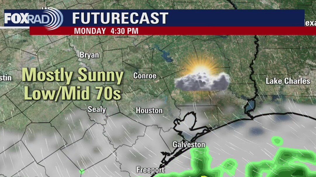
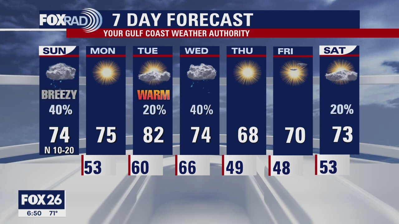
An early morning cold front moved through the area and today we?ll feel the affects of that front. It will be breezy at times with a north wind between 10 and 20 mph with rain chances slowly dropping as we work our way through the afternoon. It?s likely our warmest temperatures have already been felt, but if we are able to clear our skies before sunset, we could see those temps warm a bit. Monday is looking very nice with highs in the low and mid 70s. Things warm up quickly on Tuesday ahead of our next strong cold front on Wednesday. That?s when our next decent chance of rain and storms will return.
An early morning cold front moved through the area and today we?ll feel the affects of that front. It will be breezy at times with a north wind between 10 and 20 mph with rain chances slowly dropping as we work our way through the afternoon. It?s likely our warmest temperatures have already been felt, but if we are able to clear our skies before sunset, we could see those temps warm a bit. Monday is looking very nice with highs in the low and mid 70s. Things warm up quickly on Tuesday ahead of our next strong cold front on Wednesday. That?s when our next decent chance of rain and storms will return.
Sunday Weather Forecast
Your Gulf Coast Weather Authority Meteorologist John Dawson gives you a look ahead at Sunday's forecast.
Your Gulf Coast Weather Authority Meteorologist John Dawson gives you a look ahead at Sunday's forecast.
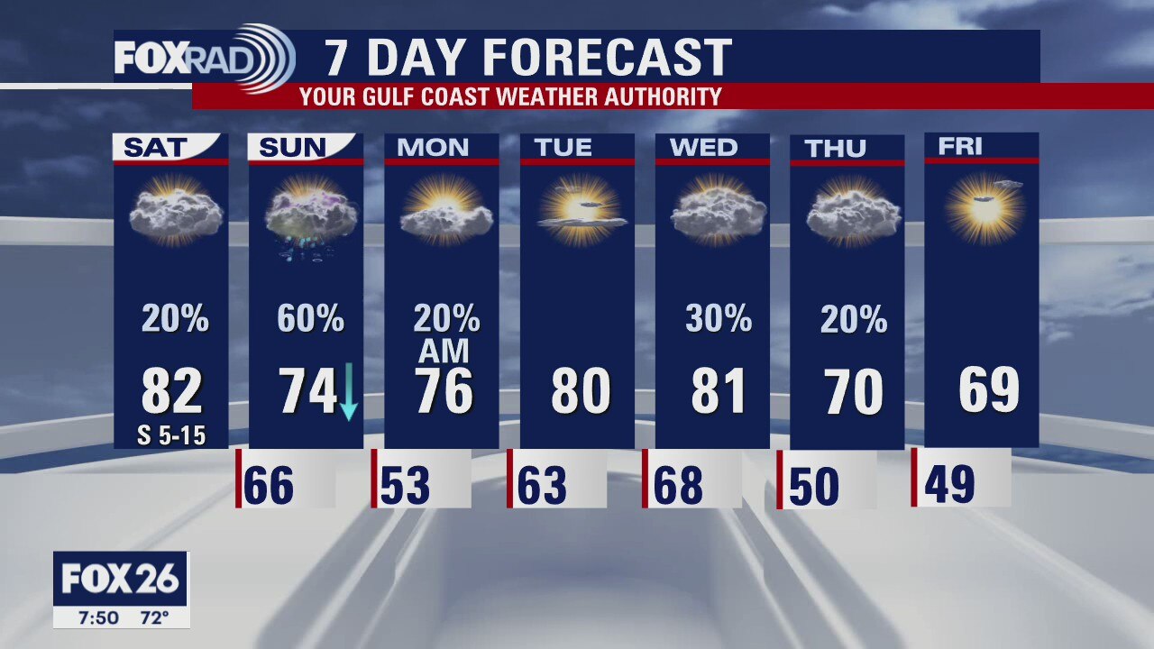
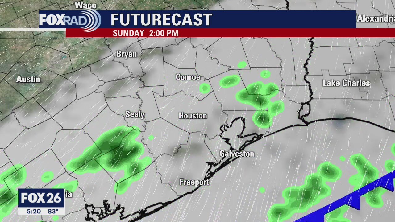
Houston-area weather forecast: March 27th
Dense fog along the coast has prompted a dense fog advisory until 10AM. As the fog dissipates, clouds will likely remain all day with patches of drizzle possible. Highs will reach the upper 70s and low 80s, but won?t be as warm as yesterday. Our better chance at seeing rain arrives on Sunday when a cold front will push through the area. Rain is possible, on and off, all day as some shower activity might persist even after the front pushes out of the region. Conditions should improve by Monday.
Dense fog along the coast has prompted a dense fog advisory until 10AM. As the fog dissipates, clouds will likely remain all day with patches of drizzle possible. Highs will reach the upper 70s and low 80s, but won?t be as warm as yesterday. Our better chance at seeing rain arrives on Sunday when a cold front will push through the area. Rain is possible, on and off, all day as some shower activity might persist even after the front pushes out of the region. Conditions should improve by Monday.
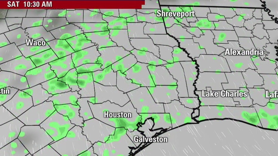
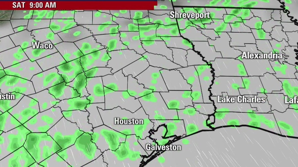
Saturday morning weather forecast
There may be a little drizzle early on Saturday as humidity rolls back into SE Texas and Houston. Rain will become likely on Sunday as the next front arrives and stalls near the coast. The skies will clear on Monday and Tuesday with slightly warmer temps. Another front will reach the area on Wednesday, which will cool the highs down into the 60s.
There may be a little drizzle early on Saturday as humidity rolls back into SE Texas and Houston. Rain will become likely on Sunday as the next front arrives and stalls near the coast. The skies will clear on Monday and Tuesday with slightly warmer temps. Another front will reach the area on Wednesday, which will cool the highs down into the 60s.
Friday evening weather forecast
There may be a little drizzle early on Saturday as humidity rolls back into SE Texas and Houston. Rain will become likely on Sunday as the next front arrives and stalls near the coast. The skies will clear on Monday and Tuesday with slightly warmer temps. Another front will reach the area on Wednesday, which will cool the highs down into the 60s.
There may be a little drizzle early on Saturday as humidity rolls back into SE Texas and Houston. Rain will become likely on Sunday as the next front arrives and stalls near the coast. The skies will clear on Monday and Tuesday with slightly warmer temps. Another front will reach the area on Wednesday, which will cool the highs down into the 60s.
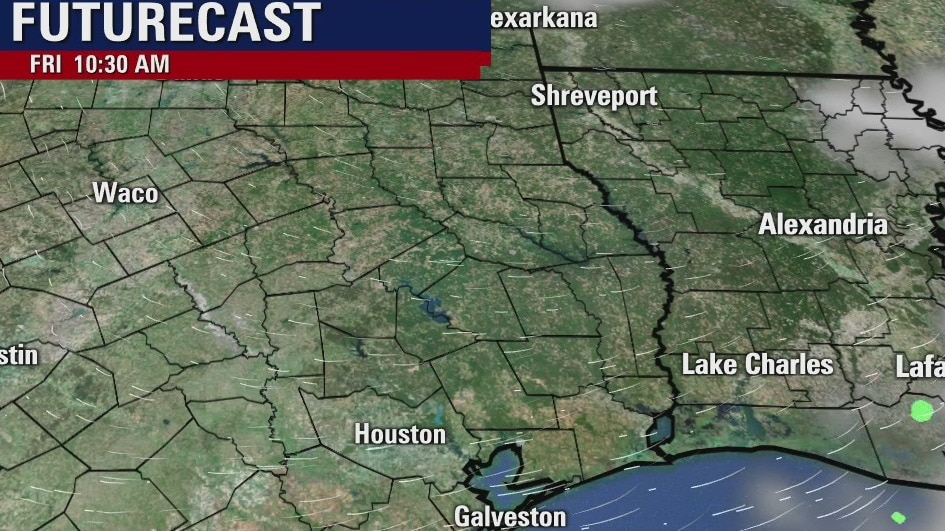
Friday weather forecast
In the wake of yesterday's cold front, we are cool this morning. The sun will be on full display today, however, so we'll have no problem warming. Highs will reach the upper 70s and low 80s. This weekend will start off dry, but may end on the wet side. A cold front will move into the region on Sunday which is why our rain chances are a bit higher toward the end of the weekend.
In the wake of yesterday's cold front, we are cool this morning. The sun will be on full display today, however, so we'll have no problem warming. Highs will reach the upper 70s and low 80s. This weekend will start off dry, but may end on the wet side. A cold front will move into the region on Sunday which is why our rain chances are a bit higher toward the end of the weekend.
Friday morning weather forecast
Friday looks great and so does Saturday until later in the evening. A front will arrive on Sunday and that will bring clouds and showers, but the skies clear for Monday and Tuesday. Another front will arrive on Wednesday next week.
Friday looks great and so does Saturday until later in the evening. A front will arrive on Sunday and that will bring clouds and showers, but the skies clear for Monday and Tuesday. Another front will arrive on Wednesday next week.
Thursday Evening Weather Forecast
The weather for SE Texas and the Houston area is rather nice today. Look at the massive storms to our east. Timing is everything when it comes to forecasting and everything bad came together over Alabama and other states nearby.
The weather for SE Texas and the Houston area is rather nice today. Look at the massive storms to our east. Timing is everything when it comes to forecasting and everything bad came together over Alabama and other states nearby.
Thursday morning weather forecast
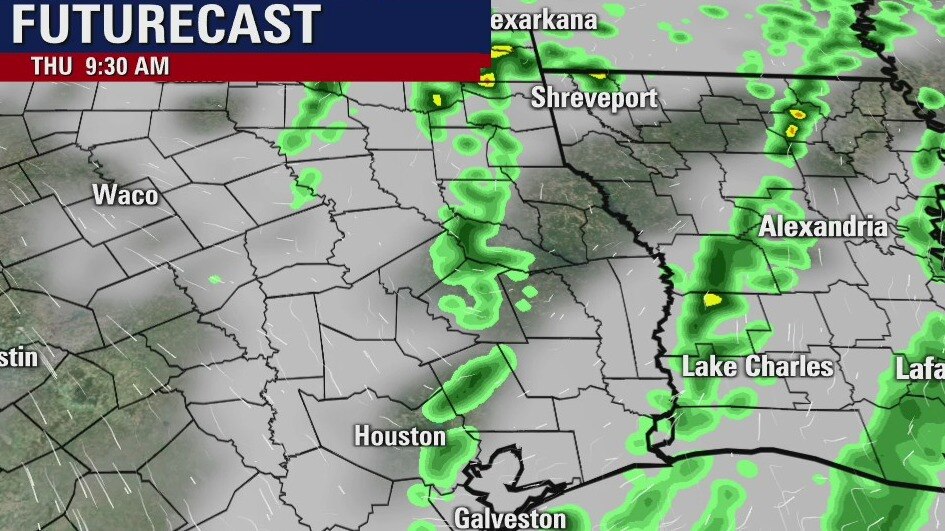
Showers and a few storms are expected across SE Texas and Houston tonight and early on Thursday. It looks like the severe storms will stay north of our area tonight and then form well to our east on Thursday. The sunshine returns by Friday, but there will be a chance for some on-and-off showers over the weekend.
Showers and a few storms are expected across SE Texas and Houston tonight and early on Thursday. It looks like the severe storms will stay north of our area tonight and then form well to our east on Thursday. The sunshine returns by Friday, but there will be a chance for some on-and-off showers over the weekend.