

Sunday Morning Weather Forecast
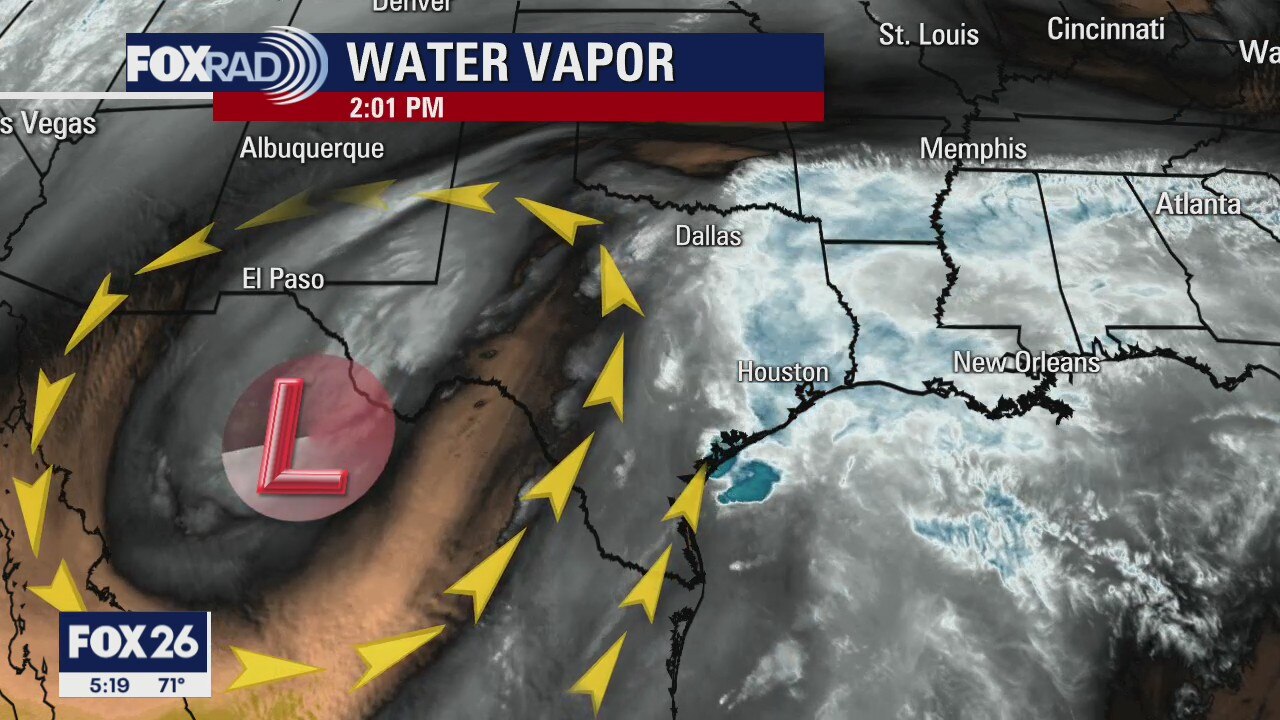
FLASH FLOOD WATCH continues until Sunday morning for most of the Houston area. Monday is looking like a hot day with temperatures in the afternoon around 90�. A front on Tuesday will bring showers and storms back in the forecast and leave the rest of the week with seasonal temperatures and very low rain chances.
FLASH FLOOD WATCH continues until Sunday morning for most of the Houston area. Monday is looking like a hot day with temperatures in the afternoon around 90�. A front on Tuesday will bring showers and storms back in the forecast and leave the rest of the week with seasonal temperatures and very low rain chances.
Houston-area weather forecast: May 1st
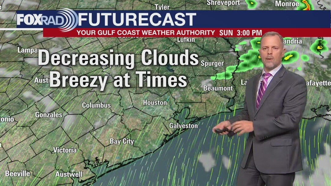
A Flash Flood Watch continues for much of the area until Sunday morning as more rain is possible tonight. The morning rain will continue to taper off; the heaviest of that rain falling over areas southwest of Houston. Temperatures will only gradually warm today as we dry out for a brief time this afternoon. Rain will finally exit the region on Sunday with temperatures warming well into the 80s on Monday. We may even reach 90 degrees before the next system brings rain and storms Tuesday.
A Flash Flood Watch continues for much of the area until Sunday morning as more rain is possible tonight. The morning rain will continue to taper off; the heaviest of that rain falling over areas southwest of Houston. Temperatures will only gradually warm today as we dry out for a brief time this afternoon. Rain will finally exit the region on Sunday with temperatures warming well into the 80s on Monday. We may even reach 90 degrees before the next system brings rain and storms Tuesday.
Saturday morning weather forecast
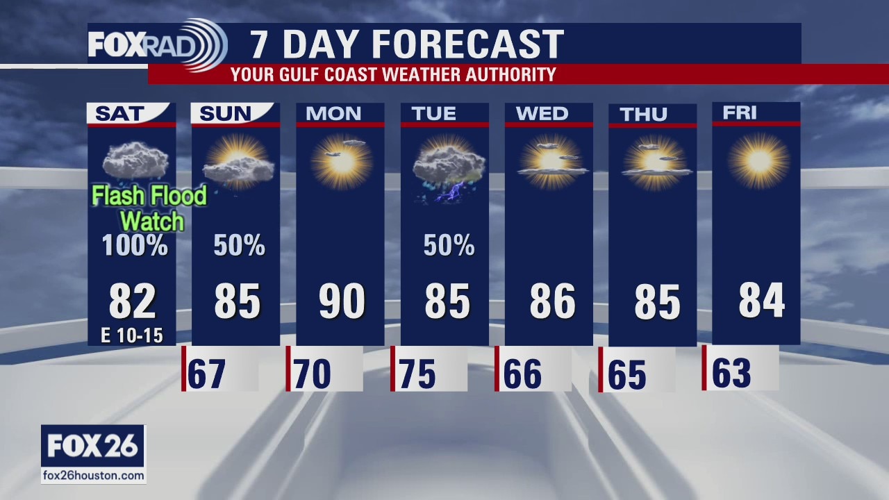
Heavy rain is expected again early Saturday and again later in the day with somewhat of a break between the two. The flash flood watch is posted until Sunday morning. Monday will be mainly a rain-free day, but a front will arrive on Tuesday bringing a quick chance for some showers. The rest of the week looks sunny, warm and dry.
Heavy rain is expected again early Saturday and again later in the day with somewhat of a break between the two. The flash flood watch is posted until Sunday morning. Monday will be mainly a rain-free day, but a front will arrive on Tuesday bringing a quick chance for some showers. The rest of the week looks sunny, warm and dry.
Friday Evening Weather Forecast
Heavy rain is expected again early Saturday and again later in the day with somewhat of a break between the two. The flash flood watch is posted until Sunday morning. Monday will be mainly a rain-free day, but a front will arrive on Tuesday bringing a quick chance for some showers. The rest of the week looks sunny, warm and dry.
Heavy rain is expected again early Saturday and again later in the day with somewhat of a break between the two. The flash flood watch is posted until Sunday morning. Monday will be mainly a rain-free day, but a front will arrive on Tuesday bringing a quick chance for some showers. The rest of the week looks sunny, warm and dry.
Friday weather forecast
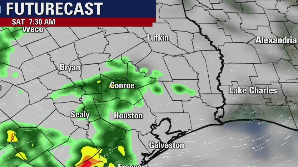
Flash Flood Watch has been issued for the entire Houston-area until 7AM Sunday. Rain, heavy at times, is likely this morning into the afternoon. We should see the rain taper off some as we head toward evening, but it's possible some areas might see more heavy rain on Saturday.
Flash Flood Watch has been issued for the entire Houston-area until 7AM Sunday. Rain, heavy at times, is likely this morning into the afternoon. We should see the rain taper off some as we head toward evening, but it's possible some areas might see more heavy rain on Saturday.
Friday weather forecast
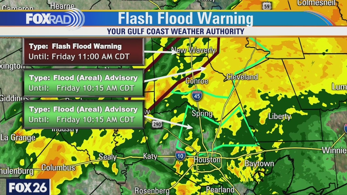
Although street flooding will remain a problem north of I-10 through late this morning conditions have been improving in the city of Houston itself. Rainfall has only been in the .25 inch to .50 inch in the last hour and the Harris County flood advisory is set to expire at 10:15 a.m.
Although street flooding will remain a problem north of I-10 through late this morning conditions have been improving in the city of Houston itself. Rainfall has only been in the .25 inch to .50 inch in the last hour and the Harris County flood advisory is set to expire at 10:15 a.m.
Friday weather forecast
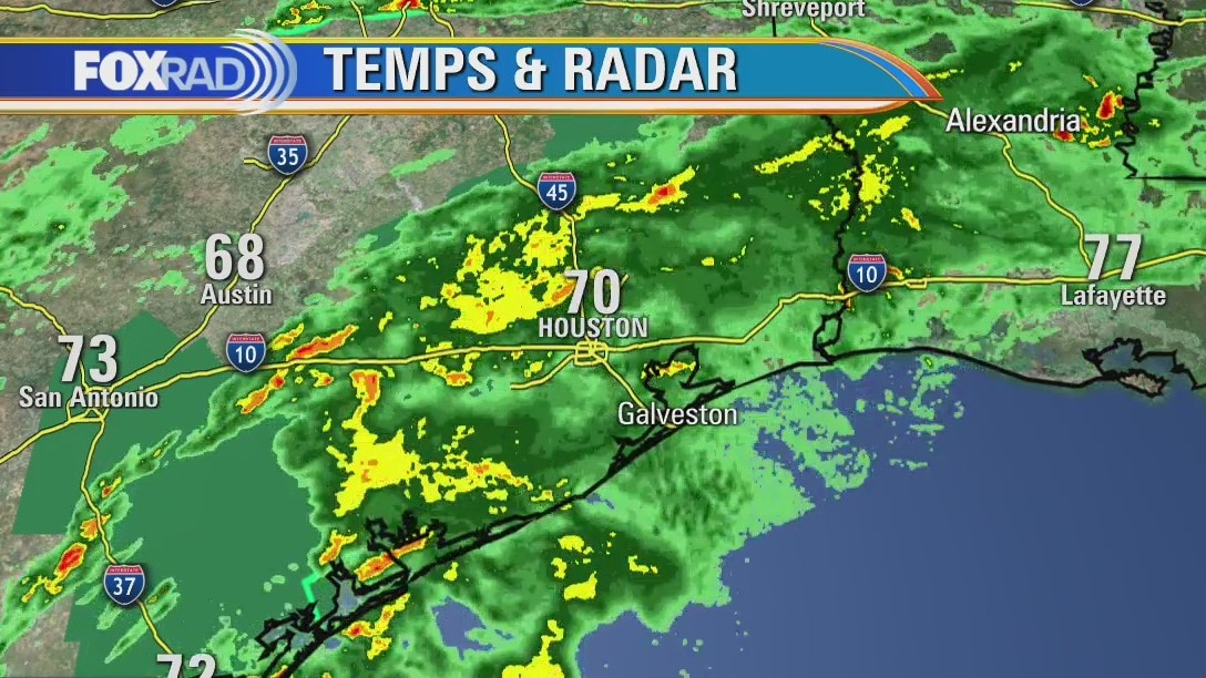
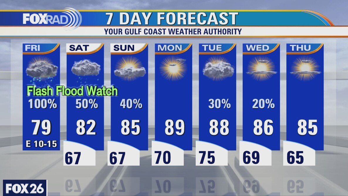
A Flash Flood Watch has been issued for the entire Houston-area until 7AM Sunday. Rain, heavy at times, is likely this morning into the afternoon. We should see the rain taper off some as we head toward evening, but it's possible some areas might see more heavy rain on Saturday. Rainfall totals could exceed 6" before the rain wraps up on Sunday, however most of us will likely see between 2 and 4 inches. Temperatures will remain mild in the mid and upper 70s to near 80 degrees. The really warm weather returns Monday with highs expected to near 90 degrees.
A Flash Flood Watch has been issued for the entire Houston-area until 7AM Sunday. Rain, heavy at times, is likely this morning into the afternoon. We should see the rain taper off some as we head toward evening, but it's possible some areas might see more heavy rain on Saturday. Rainfall totals could exceed 6" before the rain wraps up on Sunday, however most of us will likely see between 2 and 4 inches. Temperatures will remain mild in the mid and upper 70s to near 80 degrees. The really warm weather returns Monday with highs expected to near 90 degrees.
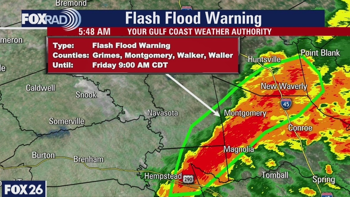
Flash flood warning until 9 a.m. for multiple Houston-area counties
A Flash Flood Watch is in effect, areawide, until Sunday morning. Rain and storms likely this morning with scattered showers possible after 2PM. Rain could be heavy at times. Highs in the upper 70s to low 80s.
A Flash Flood Watch is in effect, areawide, until Sunday morning. Rain and storms likely this morning with scattered showers possible after 2PM. Rain could be heavy at times. Highs in the upper 70s to low 80s.
Friday morning weather forecast
Storms will become likely early Friday and some of them will produce heavy rain. Rainfall totals from now until Sunday are mostly near 1-3 inches for SE Texas, but some areas could get up to 4 inches. This is going to be good for the drought.
Storms will become likely early Friday and some of them will produce heavy rain. Rainfall totals from now until Sunday are mostly near 1-3 inches for SE Texas, but some areas could get up to 4 inches. This is going to be good for the drought.
Thursday evening weather forecast
Storms will become likely early Friday and some of them will produce heavy rain. Rainfall totals from now until Sunday are mostly near 1-3 inches for SE Texas, but some areas could get up to 4 inches. This is going to be good for the drought.
Storms will become likely early Friday and some of them will produce heavy rain. Rainfall totals from now until Sunday are mostly near 1-3 inches for SE Texas, but some areas could get up to 4 inches. This is going to be good for the drought.
Thursday weather forecast
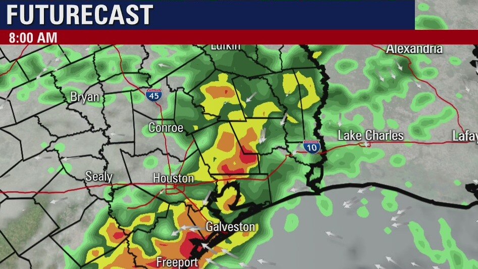
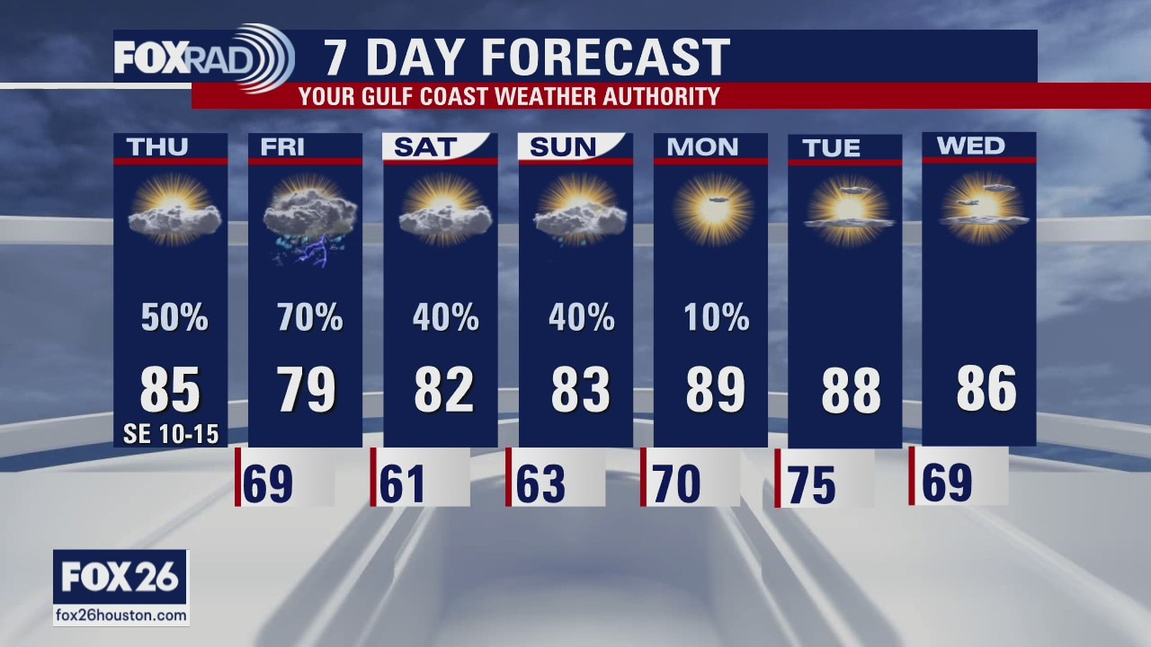
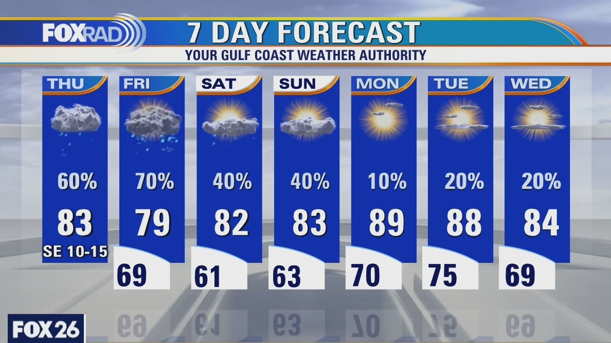
Today will be cloudy and very humid again, but with a good chance for showers and a few storms. Models are showing potential for heavier storms tomorrow followed by scattered showers this weekend. Overall rainfall for today through Sunday could exceed 4" which will help with our drought.
Today will be cloudy and very humid again, but with a good chance for showers and a few storms. Models are showing potential for heavier storms tomorrow followed by scattered showers this weekend. Overall rainfall for today through Sunday could exceed 4" which will help with our drought.
Thursday weather forecast
Mostly cloudy and humid with scattered storms likely, especially especially west and north of Houston. Highs in the mid 80s.
Mostly cloudy and humid with scattered storms likely, especially especially west and north of Houston. Highs in the mid 80s.
Thursday morning weather forecast
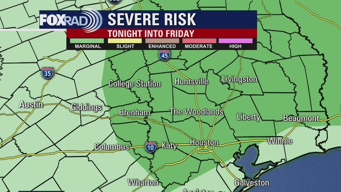
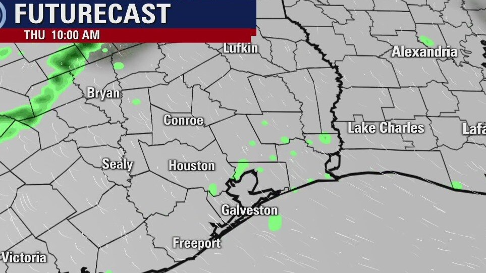
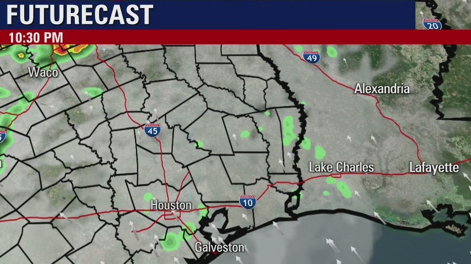
Scattered showers and a few storms are expected for Thursday. The severe weather is likely in central and north Texas, but not around the Houston area. A few smaller systems will move across the area Friday and Saturday. That will lead to some scattered showers being possible through the weekend with highs in the 80s.
Scattered showers and a few storms are expected for Thursday. The severe weather is likely in central and north Texas, but not around the Houston area. A few smaller systems will move across the area Friday and Saturday. That will lead to some scattered showers being possible through the weekend with highs in the 80s.
Wednesday evening weather forecast
Scattered showers and a few storms are expected for Thursday. The severe weather is likely in central and north Texas, but not around the Houston area. A few smaller systems will move across the area Friday and Saturday. That will lead to some scattered showers being possible through the weekend with highs in the 80s.
Scattered showers and a few storms are expected for Thursday. The severe weather is likely in central and north Texas, but not around the Houston area. A few smaller systems will move across the area Friday and Saturday. That will lead to some scattered showers being possible through the weekend with highs in the 80s.
Wednesday weather forecast
A wind advisory is in effect until 7 p.m. today along with a coastal flood advisory until 6 p.m. Tide levels will run above normal due to high onshore winds. Otherwise, look for a humid day with highs in the mid 80s. Rain is likely Thursday and scattered storms are possible through the weekend.
A wind advisory is in effect until 7 p.m. today along with a coastal flood advisory until 6 p.m. Tide levels will run above normal due to high onshore winds. Otherwise, look for a humid day with highs in the mid 80s. Rain is likely Thursday and scattered storms are possible through the weekend.
Wednesday morning weather forecast
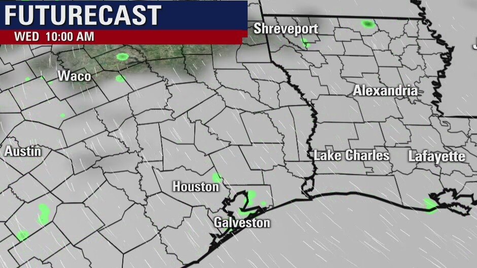
It will remain warm and humid for now. A front will arrive on Thursday bringing mainly rain to SE Texas and no severe weather. Highs will stay in the 80s and lows will dip a little heading into the weekend. Next week will bring highs closer to 90 degrees, which is somewhat normal as we head into May.
It will remain warm and humid for now. A front will arrive on Thursday bringing mainly rain to SE Texas and no severe weather. Highs will stay in the 80s and lows will dip a little heading into the weekend. Next week will bring highs closer to 90 degrees, which is somewhat normal as we head into May.
Tuesday evening weather forecast
It will remain warm and humid for now. A front will arrive on Thursday bringing mainly rain to SE Texas and no severe weather. Highs will stay in the 80s and lows will dip a little heading into the weekend. Next week will bring highs closer to 90 degrees, which is somewhat normal as we head into May.
It will remain warm and humid for now. A front will arrive on Thursday bringing mainly rain to SE Texas and no severe weather. Highs will stay in the 80s and lows will dip a little heading into the weekend. Next week will bring highs closer to 90 degrees, which is somewhat normal as we head into May.
Tuesday weather forecast
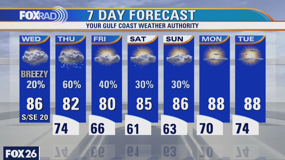
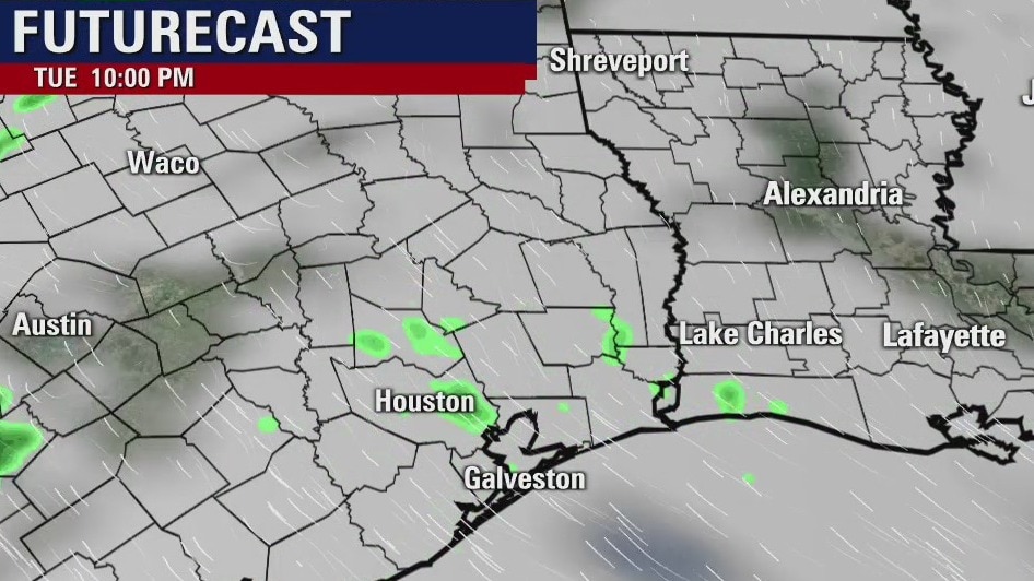
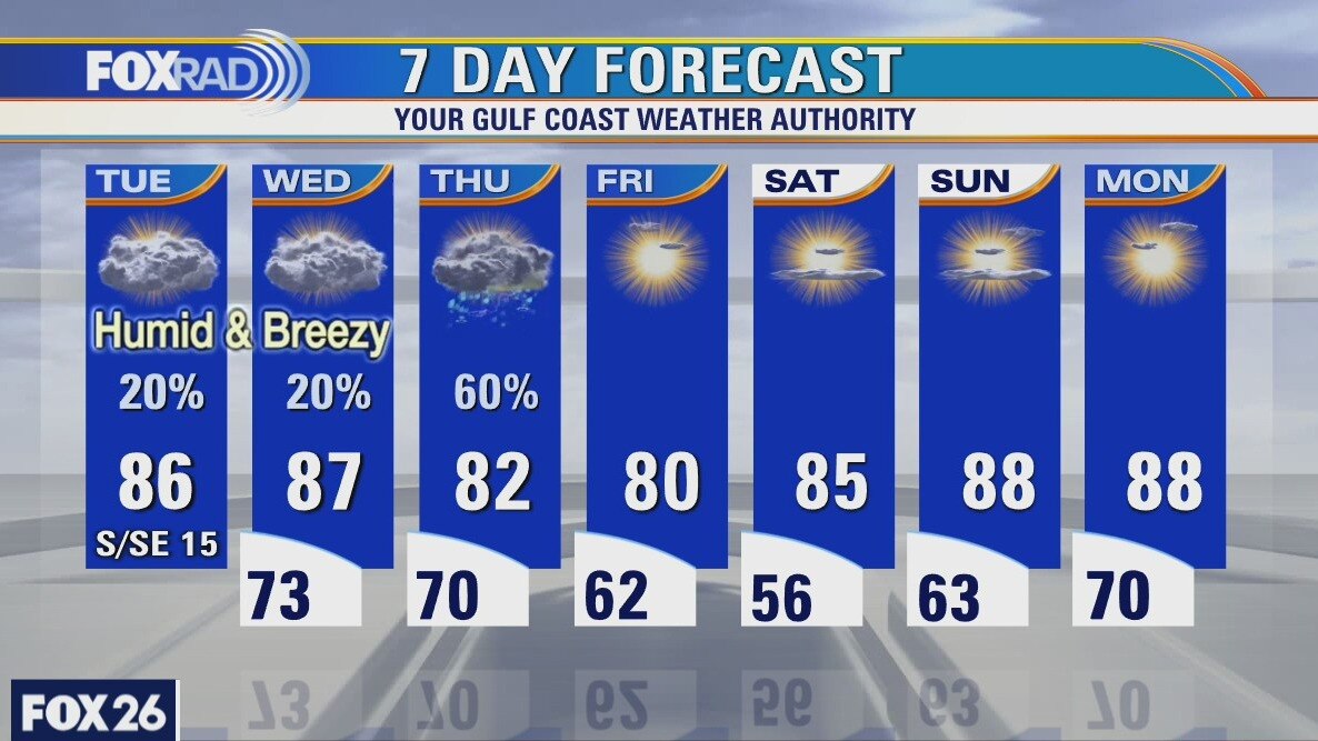
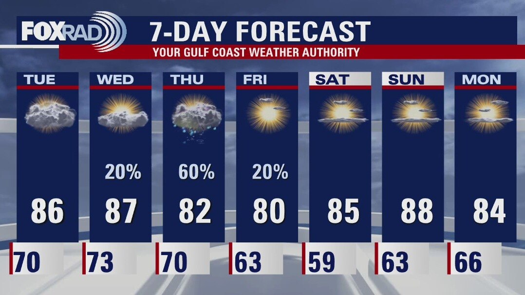
You'll be hit with humidity as soon as you open the door this morning. Humid south breezes will remain in place through Thursday, but rain chances are highest as a front moves in on Thursday. After a brief cool down on Friday and Saturday mornings, we're looking for highs near 90.
You'll be hit with humidity as soon as you open the door this morning. Humid south breezes will remain in place through Thursday, but rain chances are highest as a front moves in on Thursday. After a brief cool down on Friday and Saturday mornings, we're looking for highs near 90.
Wednesday morning weather forecast
It will be a warm week with highs in the 80s and our best chance for rain comes on Thursday as a weak front moves through. It will help drop the humidity and the even the low temps will dip into the 50s for Saturday morning. The good news is that we get the rain without any severe weather.
It will be a warm week with highs in the 80s and our best chance for rain comes on Thursday as a weak front moves through. It will help drop the humidity and the even the low temps will dip into the 50s for Saturday morning. The good news is that we get the rain without any severe weather.
Monday evening weather forecast
It will be a warm week with highs in the 80s and our best chance for rain comes on Thursday as a weak front moves through. It will help drop the humidity and the even the low temps will dip into the 50s for Saturday morning. The good news is that we get the rain without any severe weather.
It will be a warm week with highs in the 80s and our best chance for rain comes on Thursday as a weak front moves through. It will help drop the humidity and the even the low temps will dip into the 50s for Saturday morning. The good news is that we get the rain without any severe weather.