

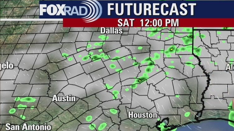
Saturday morning weather forecast
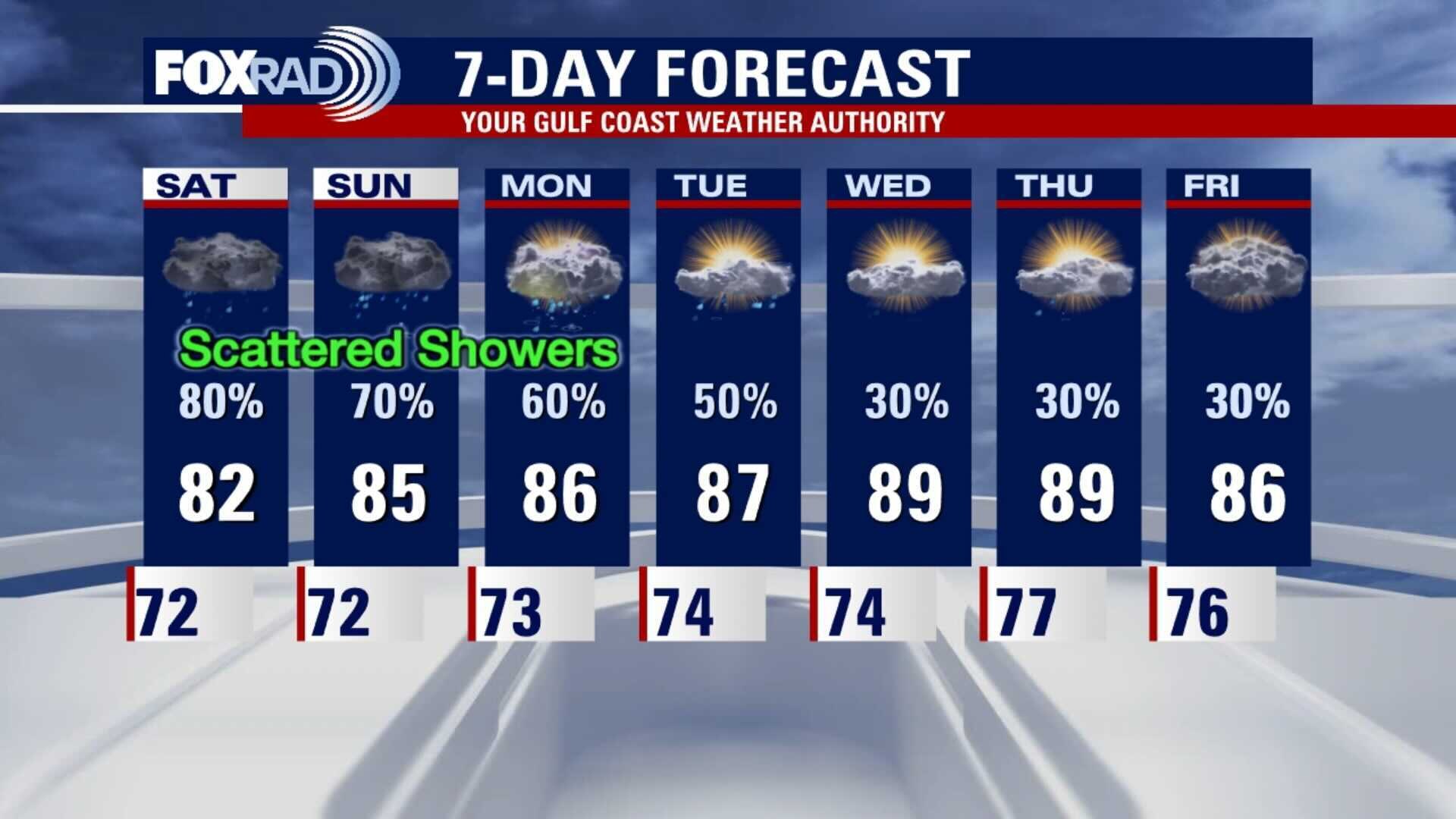
The weekend looks soggy with scattered showers, but it appears the heavy rainfall will taper off a bit. Up to an inch of rain is more likely for most areas, which would not cause flooding issues. There could still be some isolated flooding concerns if we get a few stronger storms, but most areas will not have that much rain. We get back to normal somewhat next week with just a chance for mainly afternoon showers.
The weekend looks soggy with scattered showers, but it appears the heavy rainfall will taper off a bit. Up to an inch of rain is more likely for most areas, which would not cause flooding issues. There could still be some isolated flooding concerns if we get a few stronger storms, but most areas will not have that much rain. We get back to normal somewhat next week with just a chance for mainly afternoon showers.
Friday evening weather forecast
The weekend looks soggy with scattered showers, but it appears the heavy rainfall will taper off a bit. Up to an inch of rain is more likely for most areas, which would not cause flooding issues. There could still be some isolated flooding concerns if we get a few stronger storms, but most areas will not have that much rain. We get back to normal somewhat next week with just a chance for mainly afternoon showers.
The weekend looks soggy with scattered showers, but it appears the heavy rainfall will taper off a bit. Up to an inch of rain is more likely for most areas, which would not cause flooding issues. There could still be some isolated flooding concerns if we get a few stronger storms, but most areas will not have that much rain. We get back to normal somewhat next week with just a chance for mainly afternoon showers.
Friday weather forecast
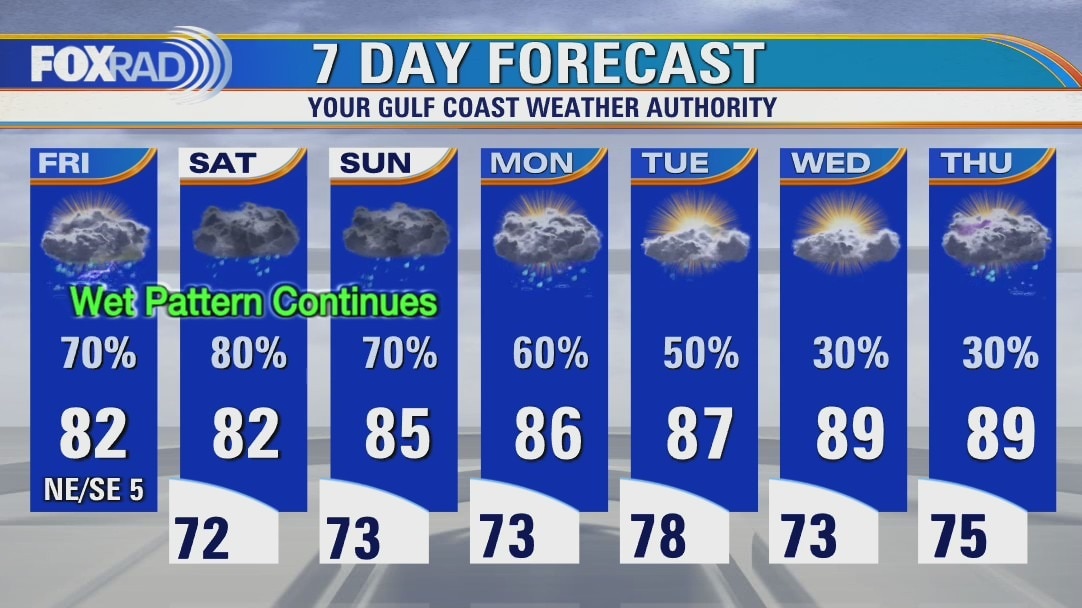
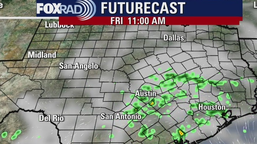
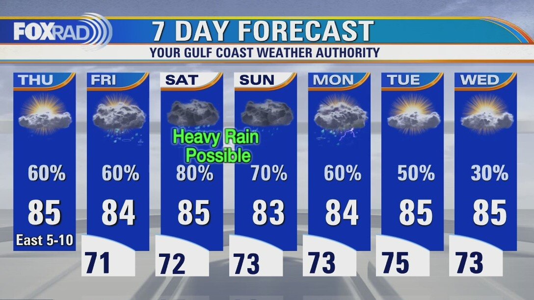
Our wet and stormy weather pattern is likely to continue today through this weekend. Some of the heavier storms could produce 2-4? of rain, so some flood advisories will be possible. Scattered showers remain in the forecast through early next week as well. High temperatures will be held into the 80s by clouds and rain.
Our wet and stormy weather pattern is likely to continue today through this weekend. Some of the heavier storms could produce 2-4? of rain, so some flood advisories will be possible. Scattered showers remain in the forecast through early next week as well. High temperatures will be held into the 80s by clouds and rain.
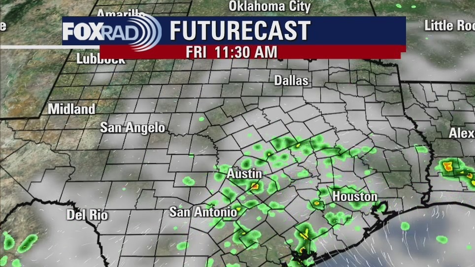
Friday morning weather forecast
The forecast continues to call for more rain across SE Texas through the weekend. Over the next five days we could easily get 5 inches of rainfall and some areas could get more. Just keep weather aware and safe over the next few days. The showers will be on and off at different times during the day.
The forecast continues to call for more rain across SE Texas through the weekend. Over the next five days we could easily get 5 inches of rainfall and some areas could get more. Just keep weather aware and safe over the next few days. The showers will be on and off at different times during the day.
Thursday evening weather forecast
The forecast continues to call for more rain across SE Texas through the weekend. Over the next five days we could easily get 5 inches of rainfall and some areas could get more. Just keep weather aware and safe over the next few days. The showers will be on and off at different times during the day.
The forecast continues to call for more rain across SE Texas through the weekend. Over the next five days we could easily get 5 inches of rainfall and some areas could get more. Just keep weather aware and safe over the next few days. The showers will be on and off at different times during the day.
Thursday weather forecast
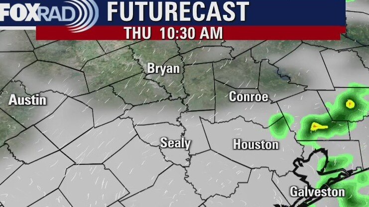
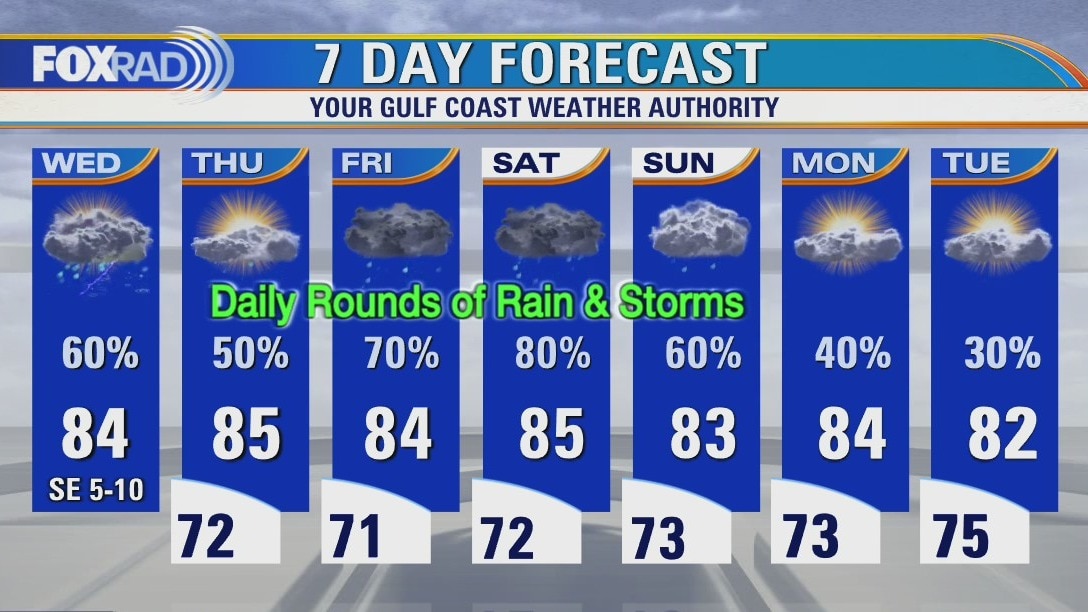
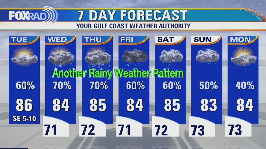
Our weather remains unsettled with several opportunities for rain over the next seven days. After an active night of storms, Thursday is starting off quiet but more storms are likely to develop once again this afternoon. Much like Wednesday, pockets of heavy rain will be possible where the storms set up. Rain is likely on Friday with our heavy rain threat ramping up this weekend. It's possible portions of the Houston-area will see 7"+ of rain before this very wet weather pattern exits by the middle of next week.
Our weather remains unsettled with several opportunities for rain over the next seven days. After an active night of storms, Thursday is starting off quiet but more storms are likely to develop once again this afternoon. Much like Wednesday, pockets of heavy rain will be possible where the storms set up. Rain is likely on Friday with our heavy rain threat ramping up this weekend. It's possible portions of the Houston-area will see 7"+ of rain before this very wet weather pattern exits by the middle of next week.
Thursday morning weather forecast
Rain chances continue to look likely on and off through the week and the weekend is looking more soggy. A large area of low pressure is sitting near California and will push disturbances toward SE Texas over the next several days. Rainfall totals for SE Texas still look between 2-4 inches for most areas through Monday and some places getting up to 5-6 inches. Flooding is possible due to the recent rainfall and saturated ground, so stay weather alert.
Rain chances continue to look likely on and off through the week and the weekend is looking more soggy. A large area of low pressure is sitting near California and will push disturbances toward SE Texas over the next several days. Rainfall totals for SE Texas still look between 2-4 inches for most areas through Monday and some places getting up to 5-6 inches. Flooding is possible due to the recent rainfall and saturated ground, so stay weather alert.
Wednesday weather forecast
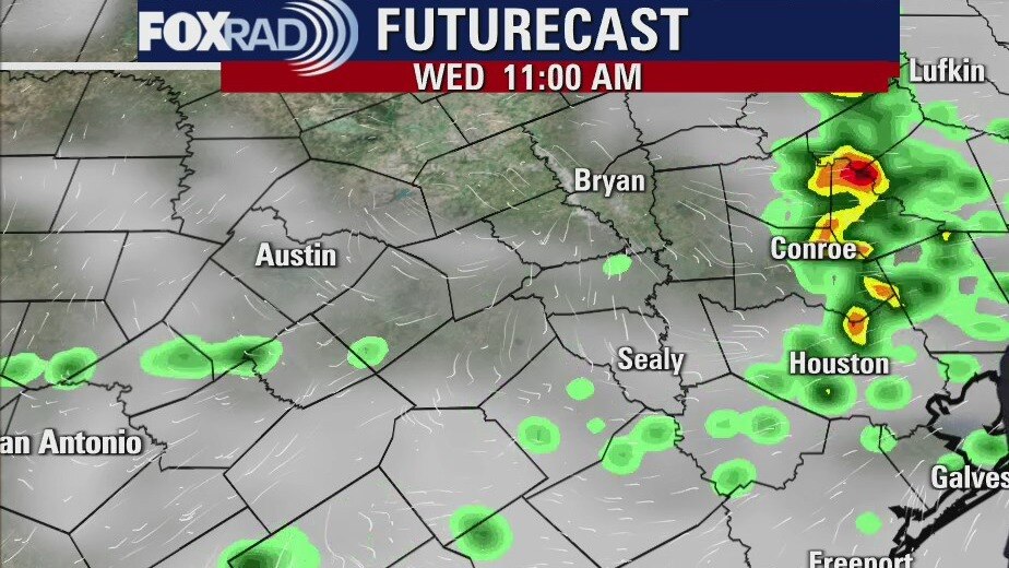
A quiet and slightly cooler start to our Wednesday, but rain is expected to develop later this afternoon with a few storms possible as we near rush hour. High temperatures will remain below average for the extended forecast, reaching the mid-80s through the weekend. Rain chances will also increase as we head toward the weekend and it does look like the weekend could be pretty wet with heavy rain possible. Timing will continue to remain the most complicated part of this forecast, but we'll be closely watching it.
A quiet and slightly cooler start to our Wednesday, but rain is expected to develop later this afternoon with a few storms possible as we near rush hour. High temperatures will remain below average for the extended forecast, reaching the mid-80s through the weekend. Rain chances will also increase as we head toward the weekend and it does look like the weekend could be pretty wet with heavy rain possible. Timing will continue to remain the most complicated part of this forecast, but we'll be closely watching it.
Wednesday morning weather forecast
SE Texas is in a soggy weather pattern for the rest of the week and weekend. Showers will be likely each day and if heavy rainfall does occur it could easily lead to possible flooding since the ground is still wet from the recent rains. A Flash Flood Watch may be necessary before the end of the week, but there isn?t one just yet.
SE Texas is in a soggy weather pattern for the rest of the week and weekend. Showers will be likely each day and if heavy rainfall does occur it could easily lead to possible flooding since the ground is still wet from the recent rains. A Flash Flood Watch may be necessary before the end of the week, but there isn?t one just yet.
Tuesday evening weather forecast
SE Texas is in a soggy weather pattern for the rest of the week and weekend. Showers will be likely each day and if heavy rainfall does occur it could easily lead to possible flooding since the ground is still wet from the recent rains. A Flash Flood Watch may be necessary before the end of the week, but there isn?t one just yet.
SE Texas is in a soggy weather pattern for the rest of the week and weekend. Showers will be likely each day and if heavy rainfall does occur it could easily lead to possible flooding since the ground is still wet from the recent rains. A Flash Flood Watch may be necessary before the end of the week, but there isn?t one just yet.
Tuesday weather forecast
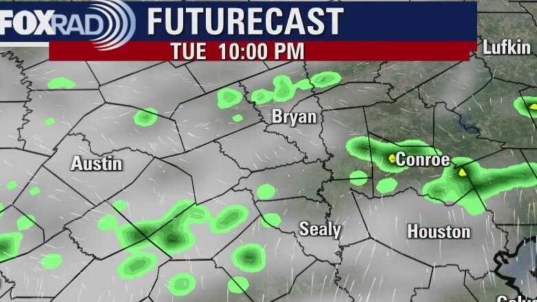
Today begins a transition back into an unsettled weather pattern that will keep rain chances high for the Houston area this week. The ground is still saturated from last week?s rain, so flooding will be a concern for areas around stronger storms. Temperatures will remain below seasonal averages with all the clouds and rain across southeast Texas.
Today begins a transition back into an unsettled weather pattern that will keep rain chances high for the Houston area this week. The ground is still saturated from last week?s rain, so flooding will be a concern for areas around stronger storms. Temperatures will remain below seasonal averages with all the clouds and rain across southeast Texas.
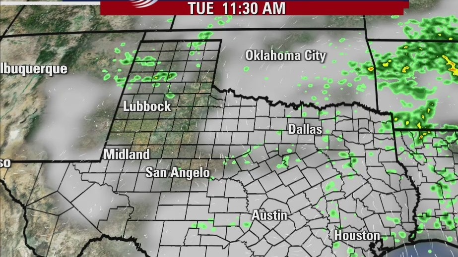
Tuesday morning weather forecast
We are about to start another rainy weather pattern that will continue for the rest of the week and weekend. There will be periods of heavy rainfall and the ground is still rather saturated. We will have to be alert for possible flooding again starting by Wednesday.
We are about to start another rainy weather pattern that will continue for the rest of the week and weekend. There will be periods of heavy rainfall and the ground is still rather saturated. We will have to be alert for possible flooding again starting by Wednesday.
Monday evening weather forecast
We are about to start another rainy weather pattern that will continue for the rest of the week and weekend. There will be periods of heavy rainfall and the ground is still rather saturated. We will have to be alert for possible flooding again starting by Wednesday.
We are about to start another rainy weather pattern that will continue for the rest of the week and weekend. There will be periods of heavy rainfall and the ground is still rather saturated. We will have to be alert for possible flooding again starting by Wednesday.
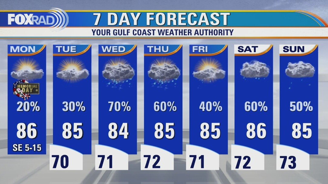
Monday weather forecast
While this week is starting off dry, it'll likely end on the wetter side. Rain chances will remain low this afternoon with highs reaching the mid and upper 80s. Areas west of I-45 will have the greatest chance of seeing a stray shower today. Then our attention shifts to the rest of the week where rounds of rain and storms will be possible. Rain chances will be highest Wednesday through Sunday.
While this week is starting off dry, it'll likely end on the wetter side. Rain chances will remain low this afternoon with highs reaching the mid and upper 80s. Areas west of I-45 will have the greatest chance of seeing a stray shower today. Then our attention shifts to the rest of the week where rounds of rain and storms will be possible. Rain chances will be highest Wednesday through Sunday.
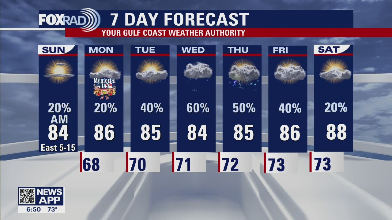
Houston-area weather forecast: May 30th
While the forecast remains mostly dry, there's now a slight chance that we could see a few showers on Sunday and Memorial Day. A few showers in Harris county early this morning should give way to a partly cloudy sky this afternoon. Shower chances along the coast might also linger until 11AM or 12PM. Highs, areawide, will likely reach the mid 80s. Rain chances remain low side for Memorial Day, but keep in mind that a stray shower might pop up in the afternoon. Higher rain chances return on Tuesday and beyond.
While the forecast remains mostly dry, there's now a slight chance that we could see a few showers on Sunday and Memorial Day. A few showers in Harris county early this morning should give way to a partly cloudy sky this afternoon. Shower chances along the coast might also linger until 11AM or 12PM. Highs, areawide, will likely reach the mid 80s. Rain chances remain low side for Memorial Day, but keep in mind that a stray shower might pop up in the afternoon. Higher rain chances return on Tuesday and beyond.
Saturday evening weather forecast
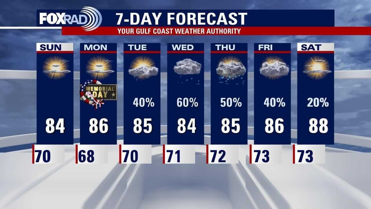
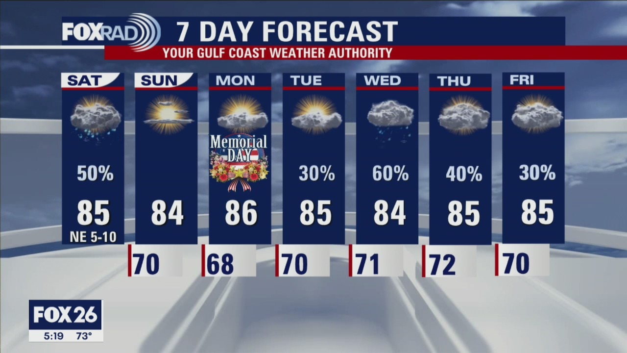
The holiday weekend will end with some pleasant weather across Southeast Texas. A weak front on Saturday has allowed winds from the north and east to bring drier air into the area. Temperatures will also run below seasonal averages with afternoon highs in the mid 80s. Memorial Day should be great for outdoor activities but rain returns quickly. Look for another rainy pattern to return to Houston starting on Tuesday.
The holiday weekend will end with some pleasant weather across Southeast Texas. A weak front on Saturday has allowed winds from the north and east to bring drier air into the area. Temperatures will also run below seasonal averages with afternoon highs in the mid 80s. Memorial Day should be great for outdoor activities but rain returns quickly. Look for another rainy pattern to return to Houston starting on Tuesday.
Houston-area weather forecast: May 29th
Showers and storms remain a possibility on Saturday with drier conditions expected to filter in for Sunday and Monday. Our wet weather isn't over yet, though, as more opportunities for rain arrive on Monday and last through most of the week. Highs each day will likely stay below average, reaching the low and mid 80s.
Showers and storms remain a possibility on Saturday with drier conditions expected to filter in for Sunday and Monday. Our wet weather isn't over yet, though, as more opportunities for rain arrive on Monday and last through most of the week. Highs each day will likely stay below average, reaching the low and mid 80s.

Saturday morning weather forecast with Meteorologist Stephen Morgan
Some heavy rain poured down the evening Friday night. FOX 26 Houston Meteorologist Stephen Morgan tells us what the weather has in store for us as we roll into Memorial Day Weekend.
Some heavy rain poured down the evening Friday night. FOX 26 Houston Meteorologist Stephen Morgan tells us what the weather has in store for us as we roll into Memorial Day Weekend.

Friday evening weather with Meteorologist Stephen Morgan
We had a muggy start to our Friday and storms will continue on Saturday before a sunny Sunday and Monday for your Memorial Day Weekend celebrations. Our Meteorologist Stephen Morgan has more with your FOX 26 Weather.
We had a muggy start to our Friday and storms will continue on Saturday before a sunny Sunday and Monday for your Memorial Day Weekend celebrations. Our Meteorologist Stephen Morgan has more with your FOX 26 Weather.
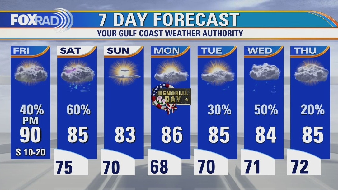
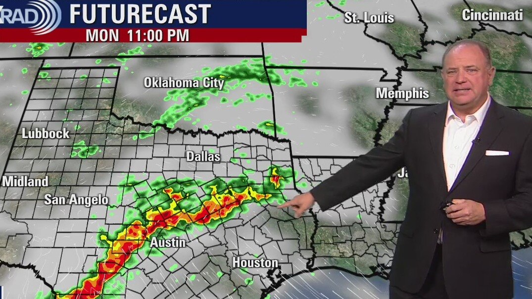
Friday weather forecast
Another mild and muggy start to our day with showers to the north of Houston trying to edge farther south. We'll see isolated showers this morning and then a bit of a break this afternoon. Storms will possibly redevelop this afternoon and could push through the Houston-area as we near sunset. Temperatures, this afternoon, will warm into the upper 80s and low 90s. Saturday carries our highest rain chance with quiet and sunny weather expected Sunday into Monday.
Another mild and muggy start to our day with showers to the north of Houston trying to edge farther south. We'll see isolated showers this morning and then a bit of a break this afternoon. Storms will possibly redevelop this afternoon and could push through the Houston-area as we near sunset. Temperatures, this afternoon, will warm into the upper 80s and low 90s. Saturday carries our highest rain chance with quiet and sunny weather expected Sunday into Monday.