

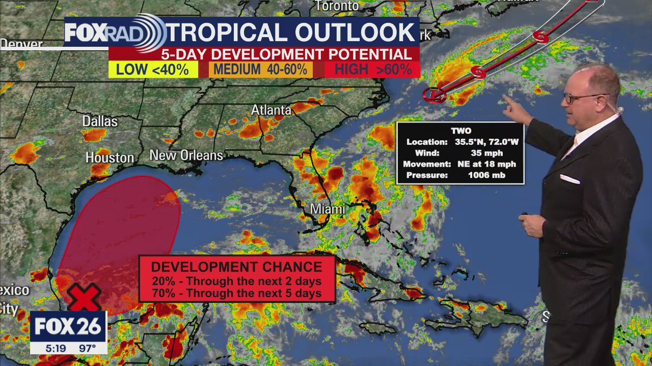
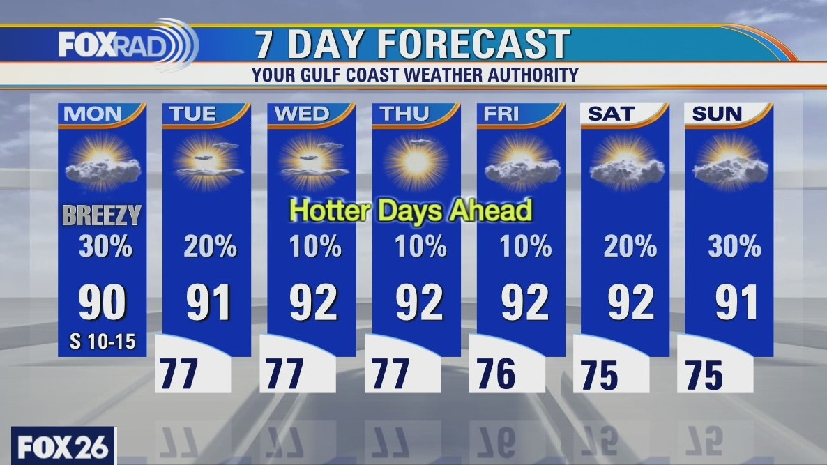
Monday Evening Weather Forecast
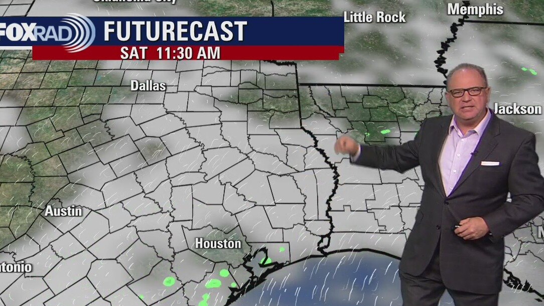
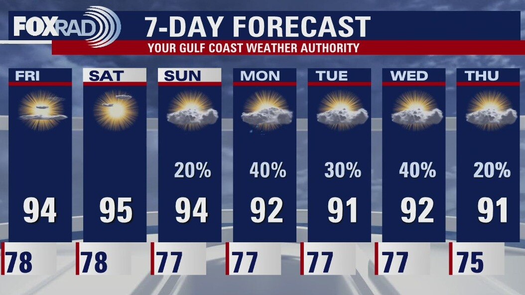
It will be a very hot and humid week with highs in the middle 90s and heat index values in the low 100s. Rain chances will rise over the weekend as a tropical low may pass just to the east of the Houston area, but that may change. We will have a much better idea when the low actually forms in the southern Gulf and the computer models center on it. We will keep a watchful eye on it.
It will be a very hot and humid week with highs in the middle 90s and heat index values in the low 100s. Rain chances will rise over the weekend as a tropical low may pass just to the east of the Houston area, but that may change. We will have a much better idea when the low actually forms in the southern Gulf and the computer models center on it. We will keep a watchful eye on it.
Monday weather forecast
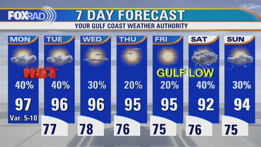
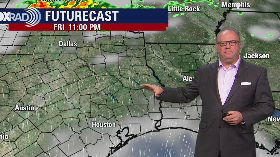
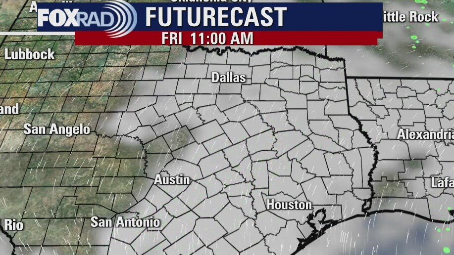
Get ready for another scorcher of a day. Highs all this week will run in the mid to upper 90s along with isolated afternoon storms. The tropics are heating up, too. A low in the far southern Gulf is likely to organize this week, but its track is uncertain. Another small system off the coast of the Carolinas could be upgraded to a tropical depression today, but will have no effect on our area.
Get ready for another scorcher of a day. Highs all this week will run in the mid to upper 90s along with isolated afternoon storms. The tropics are heating up, too. A low in the far southern Gulf is likely to organize this week, but its track is uncertain. Another small system off the coast of the Carolinas could be upgraded to a tropical depression today, but will have no effect on our area.
Houston-area weather forecast: June 13th
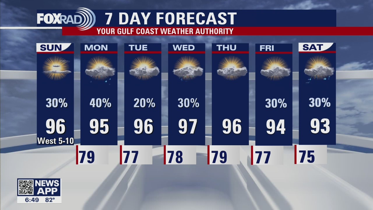
More heat expected on Sunday with highs likely to reach the mid and upper 90s. This comes on the heels of our hottest day of the year! Bush Airport recorded a high of 98? on Saturday and we'll be making another run at it again today. One difference this afternoon will be the threat for storms. Most areas will remain dry, but it's possible we see storms after 3PM so keep an eye to the sky. Our rain chances continue for most of next week as our temperatures remain on the high side, warming into the mid and upper 90s each day.
More heat expected on Sunday with highs likely to reach the mid and upper 90s. This comes on the heels of our hottest day of the year! Bush Airport recorded a high of 98? on Saturday and we'll be making another run at it again today. One difference this afternoon will be the threat for storms. Most areas will remain dry, but it's possible we see storms after 3PM so keep an eye to the sky. Our rain chances continue for most of next week as our temperatures remain on the high side, warming into the mid and upper 90s each day.
Houston-area weather forecast: June 12th
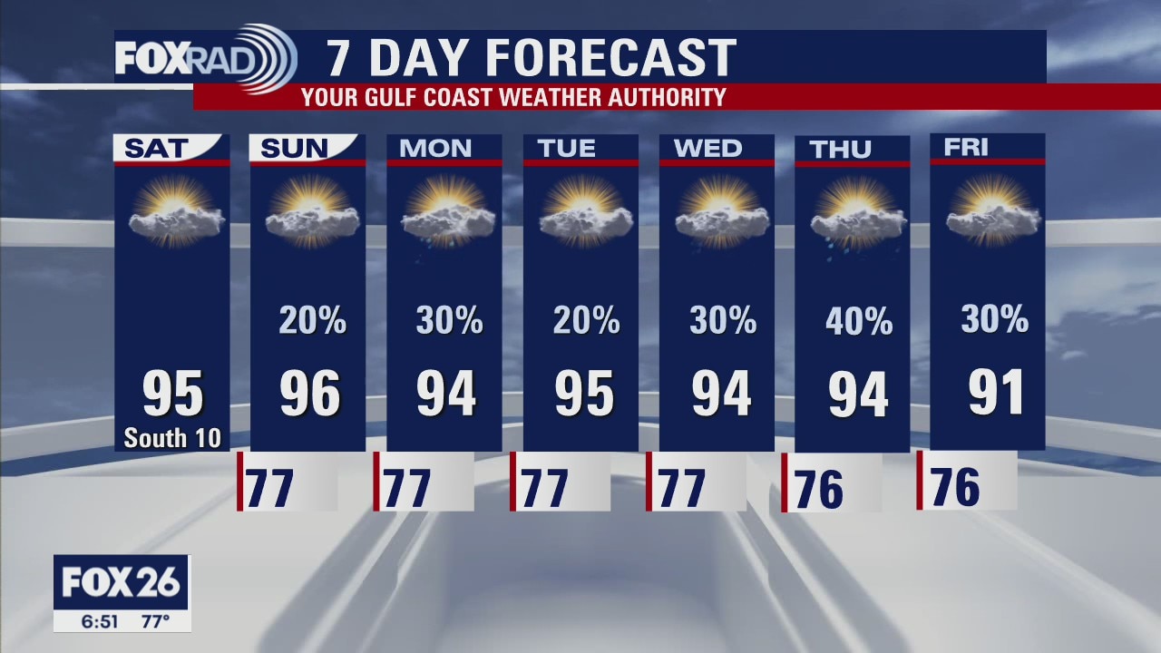
Our warm and muggy weather pattern continues this weekend with highs, on Saturday, expected to reach the mid 90s. Don't forget to take frequent breaks if you have to be out in the heat for prolonged periods! Rain chances return on Sunday as a weak boundary could develop a few showers and storms. It'll still be hot, with highs reaching the mid 90s again. The next week will remain on the unsettled sides with several opportunities for rain, however chances do remain low.
Our warm and muggy weather pattern continues this weekend with highs, on Saturday, expected to reach the mid 90s. Don't forget to take frequent breaks if you have to be out in the heat for prolonged periods! Rain chances return on Sunday as a weak boundary could develop a few showers and storms. It'll still be hot, with highs reaching the mid 90s again. The next week will remain on the unsettled sides with several opportunities for rain, however chances do remain low.
Saturday morning weather forecast
Temps will be hot and the humidity will be sticky heading into the weekend. A back-door front will stall near the Houston area early next week and that will bring showers back into the forecast. The temps will also drop by a few degrees, which isn?t too much. We are still monitoring the long range models indicating a tropical low could form in the southwestern Gulf in just over 10 days. It?s still very early, but we will keep an eye on it.
Temps will be hot and the humidity will be sticky heading into the weekend. A back-door front will stall near the Houston area early next week and that will bring showers back into the forecast. The temps will also drop by a few degrees, which isn?t too much. We are still monitoring the long range models indicating a tropical low could form in the southwestern Gulf in just over 10 days. It?s still very early, but we will keep an eye on it.
Friday evening weather forecast
The weekend looks warm and quiet with maybe a few showers or storms on Sunday. The coming week will have a daily chance for rain, but it won't be overly soggy like we had a couple of weeks ago. We will also keep watching for a possible low in the southern Gulf. There isn?t much going on yet, but that could change sometime next week.
The weekend looks warm and quiet with maybe a few showers or storms on Sunday. The coming week will have a daily chance for rain, but it won't be overly soggy like we had a couple of weeks ago. We will also keep watching for a possible low in the southern Gulf. There isn?t much going on yet, but that could change sometime next week.

Friday morning weather with Meteorologist Stephen Morgan
We are off to another mild and muggy start. Temperatures, this afternoon, will likely warm into the mid 90s with mostly sunny skies. Rain chances will remain limited until Sunday afternoon when a few showers could develop along a weak front that'll be moving into the region. Other than that, rain chances remain slim as temperatures remain hot. Also of note, we'll be watching the southern Gulf as we work toward the beginning of next week for potential tropical development. A lot of uncertainty regarding what might develop, but there are signs that some tropical moisture could move toward the Gulf coast as we head into Father's Day weekend.
We are off to another mild and muggy start. Temperatures, this afternoon, will likely warm into the mid 90s with mostly sunny skies. Rain chances will remain limited until Sunday afternoon when a few showers could develop along a weak front that'll be moving into the region. Other than that, rain chances remain slim as temperatures remain hot. Also of note, we'll be watching the southern Gulf as we work toward the beginning of next week for potential tropical development. A lot of uncertainty regarding what might develop, but there are signs that some tropical moisture could move toward the Gulf coast as we head into Father's Day weekend.
Friday morning weather forecast
Temps will be hot and the humidity will be sticky heading into the weekend. A back-door front will stall near the Houston area early next week and that will bring showers back into the forecast. The temps will also drop by a few degrees, which isn?t too much. We are still monitoring the long range models indicating a tropical low could form in the southwestern Gulf in just over 10 days. It?s still very early, but we will keep an eye on it.
Temps will be hot and the humidity will be sticky heading into the weekend. A back-door front will stall near the Houston area early next week and that will bring showers back into the forecast. The temps will also drop by a few degrees, which isn?t too much. We are still monitoring the long range models indicating a tropical low could form in the southwestern Gulf in just over 10 days. It?s still very early, but we will keep an eye on it.
Thursday evening weather forecast
Temps will be hot and the humidity will be sticky heading into the weekend. A back-door front will stall near the Houston area early next week and that will bring showers back into the forecast. The temps will also drop by a few degrees, which isn?t too much. We are still monitoring the long range models indicating a tropical low could form in the southwestern Gulf in just over 10 days. It?s still very early, but we will keep an eye on it.
Temps will be hot and the humidity will be sticky heading into the weekend. A back-door front will stall near the Houston area early next week and that will bring showers back into the forecast. The temps will also drop by a few degrees, which isn?t too much. We are still monitoring the long range models indicating a tropical low could form in the southwestern Gulf in just over 10 days. It?s still very early, but we will keep an eye on it.

Thursday morning weather with Meteorologist Mike Iscovitz
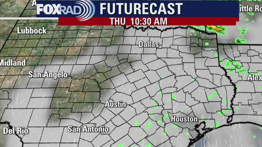
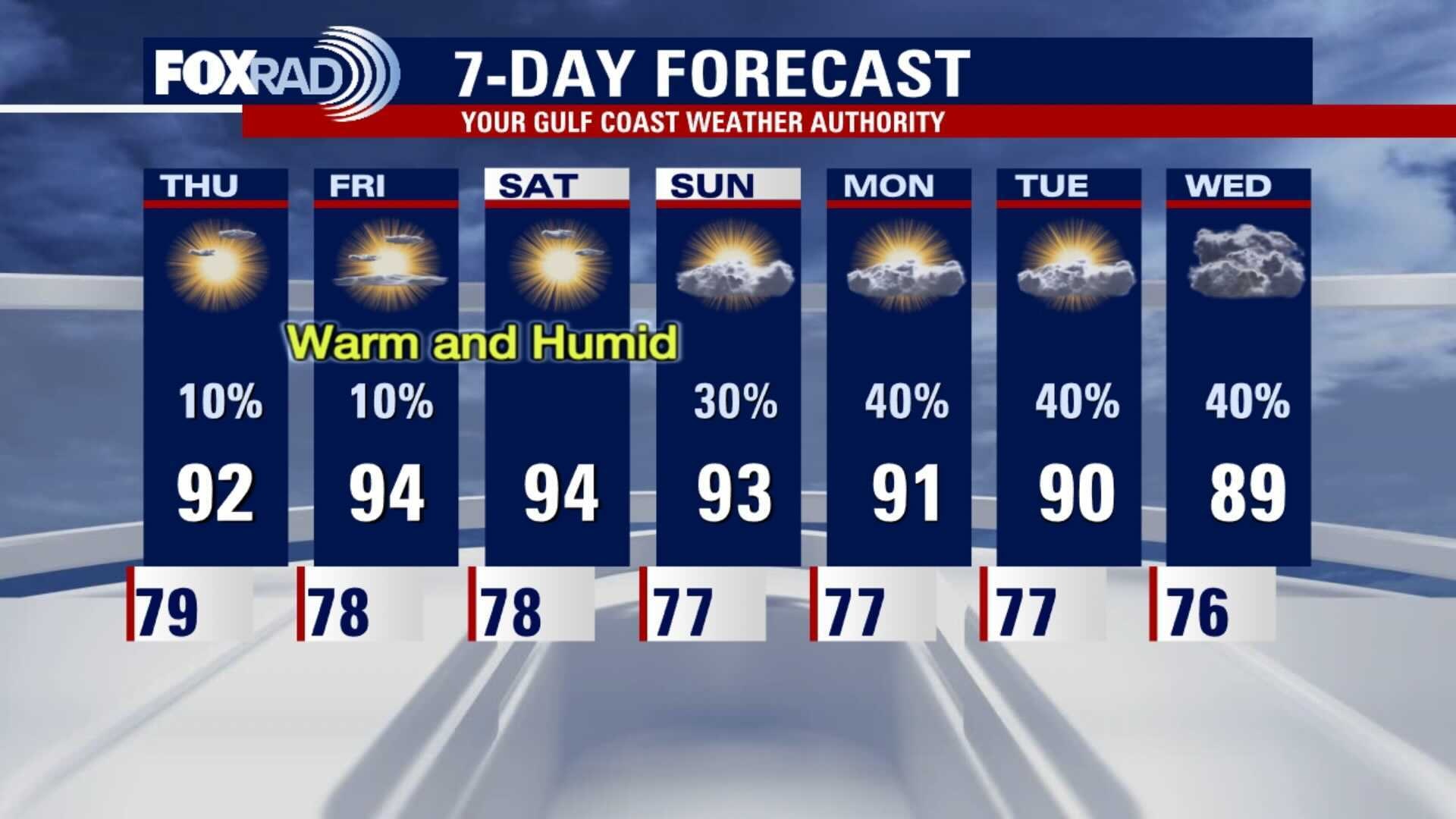
It will remain hot and humid for the rest of the week. Rain chances will go back up starting on Sunday. A front will back into SE Texas next week and that will bring unsettled weather for a few days. Scattered showers will form each day with brief downpours which will at least cool the temps a little.
It will remain hot and humid for the rest of the week. Rain chances will go back up starting on Sunday. A front will back into SE Texas next week and that will bring unsettled weather for a few days. Scattered showers will form each day with brief downpours which will at least cool the temps a little.
Thursday morning weather forecast
It will remain hot and humid for the rest of the week. Rain chances will go back up starting on Sunday. A front will back into SE Texas next week and that will bring unsettled weather for a few days. Scattered showers will form each day with brief downpours which will at least cool the temps a little.
It will remain hot and humid for the rest of the week. Rain chances will go back up starting on Sunday. A front will back into SE Texas next week and that will bring unsettled weather for a few days. Scattered showers will form each day with brief downpours which will at least cool the temps a little.
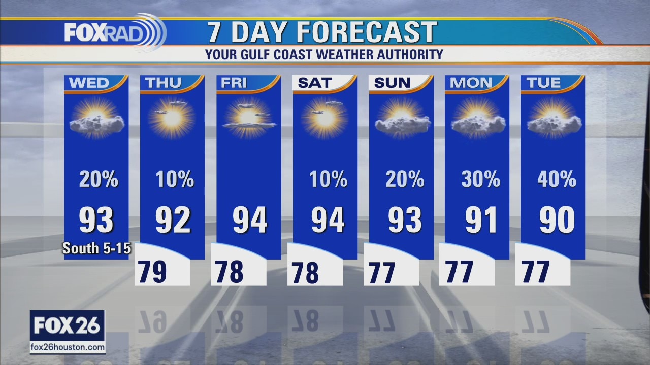
Wednesday evening weather forecast with Chief Meteorologist Dr. Jim Siebert
It will remain hot and humid for the rest of the week. Rain chances will go back up starting on Sunday. A front will back into southeast Texas next week and that will bring unsettled weather for a few days. Scattered showers will form each day with brief downpours which will at least cool the temps a little.
It will remain hot and humid for the rest of the week. Rain chances will go back up starting on Sunday. A front will back into southeast Texas next week and that will bring unsettled weather for a few days. Scattered showers will form each day with brief downpours which will at least cool the temps a little.
Wednesday weather forecast
Partly cloudy, hot and humid with highs in the low 90s and a heat index above 100.
Partly cloudy, hot and humid with highs in the low 90s and a heat index above 100.
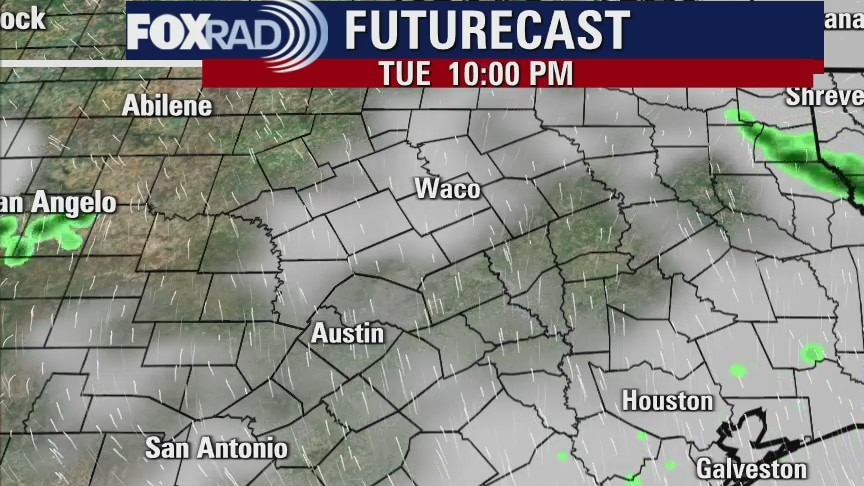
Tuesday evening weather forecast
The weather is back to normal, which means hot, humid and a slight chance for mainly an afternoon shower or two. Highs will be in the 90s, but it will feel closer to the low 100s. Look for a slightly better chance for some rain next week.
The weather is back to normal, which means hot, humid and a slight chance for mainly an afternoon shower or two. Highs will be in the 90s, but it will feel closer to the low 100s. Look for a slightly better chance for some rain next week.

Tuesday weather forecast
Good Tuesday morning and welcome to another super muggy day. Lows this morning stayed above 80 in most spots and we're looking for another typical early June day with highs in the low 90s. The rest of the week looks warm and humid with highs in the low to mid 90s.
Good Tuesday morning and welcome to another super muggy day. Lows this morning stayed above 80 in most spots and we're looking for another typical early June day with highs in the low 90s. The rest of the week looks warm and humid with highs in the low to mid 90s.
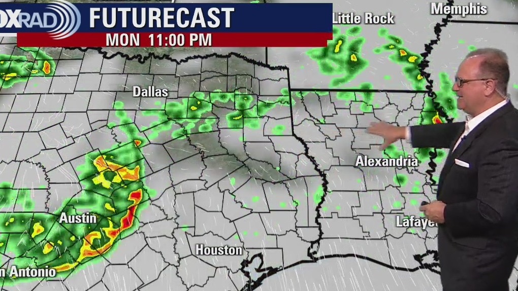
Monday evening weather forecast
After today, there will only be a 10% to 20% chance for showers for the rest of the week. It will be very warm and humid, which is more normal for this time of year.
After today, there will only be a 10% to 20% chance for showers for the rest of the week. It will be very warm and humid, which is more normal for this time of year.
Monday weather forecast
It's a very muggy Monday with a chance for late day storms especially north of Houston. The rest of the week looks hot, humid and breezy with only isolated showers or storms. The tropics remain quiet nearby, but a small low may form in the far southern Caribbean this week.
It's a very muggy Monday with a chance for late day storms especially north of Houston. The rest of the week looks hot, humid and breezy with only isolated showers or storms. The tropics remain quiet nearby, but a small low may form in the far southern Caribbean this week.
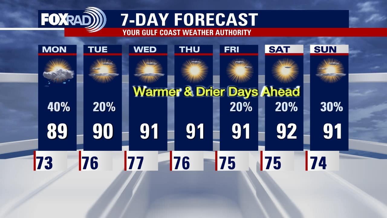
Sunday evening weather forecast with Meteorologist John Dawson
The rainy pattern for Southeast Texas is coming to an end. Look for a midday round of showers/storms on Monday with a breezy and warm afternoon. The lower 90s return in the afternoons for the rest of the week. Rain chances drop to 20% or less starting on Tuesday. Get ready to embrace a typical Houston June weather pattern for most of the week.
The rainy pattern for Southeast Texas is coming to an end. Look for a midday round of showers/storms on Monday with a breezy and warm afternoon. The lower 90s return in the afternoons for the rest of the week. Rain chances drop to 20% or less starting on Tuesday. Get ready to embrace a typical Houston June weather pattern for most of the week.
Sunday weather with Meteorologist Mike Iscovitz
Expect a few more scattered showers and storms today with warm, humid weather in between. High pressure is likely to build later this week and that should result in hotter afternoons with daily highs in the low 90s along with a heat index close to 100.
Expect a few more scattered showers and storms today with warm, humid weather in between. High pressure is likely to build later this week and that should result in hotter afternoons with daily highs in the low 90s along with a heat index close to 100.

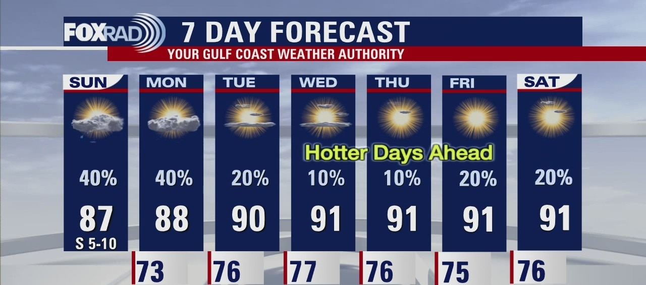
Houston-area weather forecast: June 5th
We're dealing with patchy fog this morning, but that should dissipate over the next couple of hours. Showers are already popping up on radar and more rain is expected to develop, especially along the coast this afternoon. Heavy rain continues to be a threat, but the rain won't be as widespread; it'll remain scattered. Rain chances remain high on Sunday and we'll continue to see that threat for rain on Monday, but we should see our conditions improve as we head toward midweek. Temperatures will gradually warm as we decrease that rain threat with highs in the upper 80s and 90s by Thursday and beyond.
We're dealing with patchy fog this morning, but that should dissipate over the next couple of hours. Showers are already popping up on radar and more rain is expected to develop, especially along the coast this afternoon. Heavy rain continues to be a threat, but the rain won't be as widespread; it'll remain scattered. Rain chances remain high on Sunday and we'll continue to see that threat for rain on Monday, but we should see our conditions improve as we head toward midweek. Temperatures will gradually warm as we decrease that rain threat with highs in the upper 80s and 90s by Thursday and beyond.