

Wednesday weather forecast
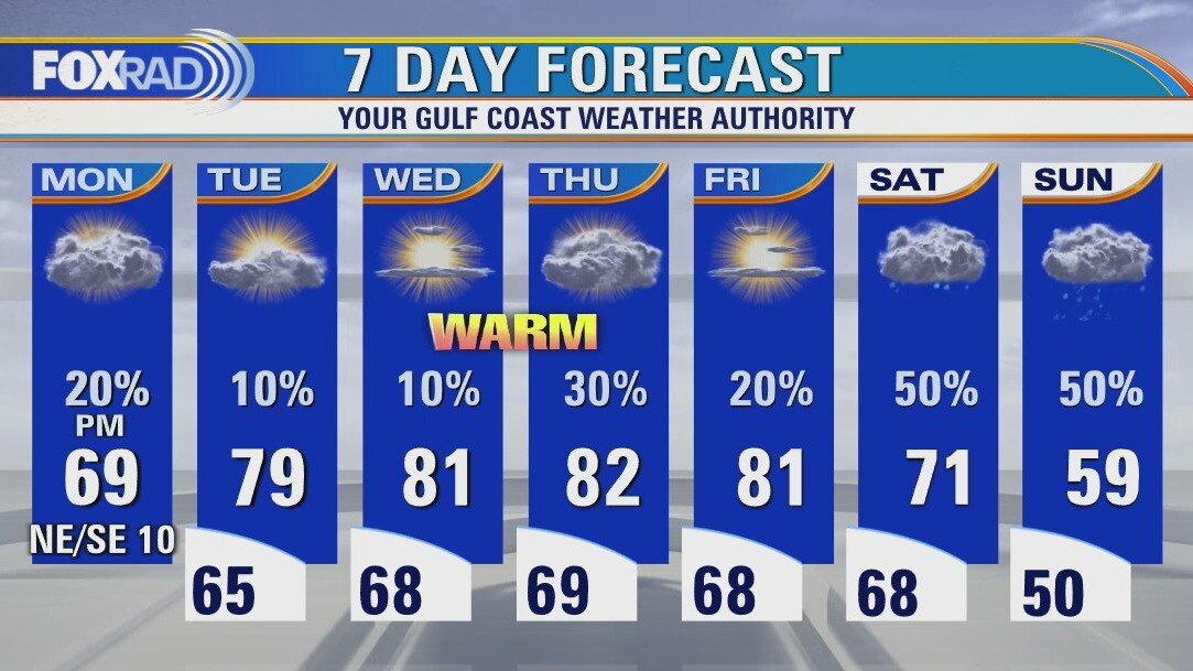
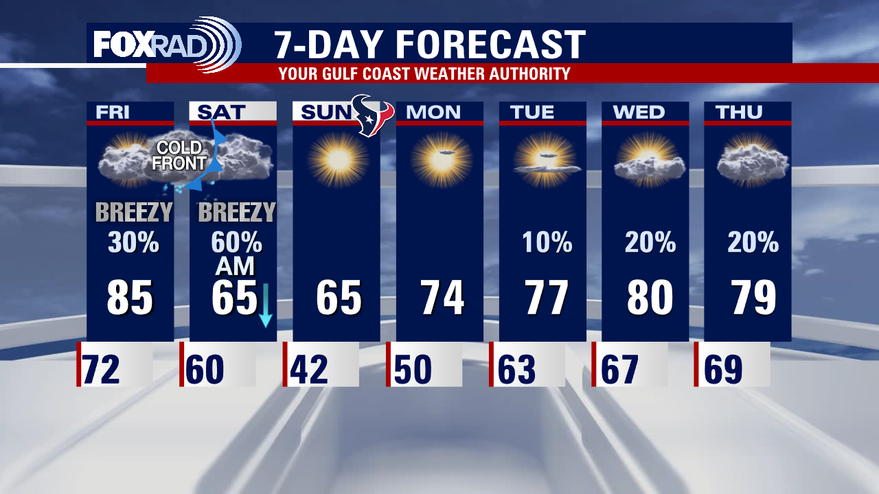
More unprecedented warmth is on the way for today through Friday with records highs at risk each day. Monday's high of 79 in Galveston and 83 at Hobby were both record highs. Expect big changes this weekend with a slow-moving front bringing rain and cooler air.
More unprecedented warmth is on the way for today through Friday with records highs at risk each day. Monday's high of 79 in Galveston and 83 at Hobby were both record highs. Expect big changes this weekend with a slow-moving front bringing rain and cooler air.
Wednesday morning weather forecast
It will continue to be warm and humid for the rest of the workweek. Patchy fog will also stay in the forecast during the morning hours. A front will arrive by Saturday and that's when the rain will become likely across the region.
It will continue to be warm and humid for the rest of the workweek. Patchy fog will also stay in the forecast during the morning hours. A front will arrive by Saturday and that's when the rain will become likely across the region.
Tuesday evening weather forecast
It will continue to be warm and humid for the rest of the workweek. Patchy fog will also stay in the forecast during the morning hours. A front will arrive by Saturday and that's when the rain will become likely across the region.
It will continue to be warm and humid for the rest of the workweek. Patchy fog will also stay in the forecast during the morning hours. A front will arrive by Saturday and that's when the rain will become likely across the region.
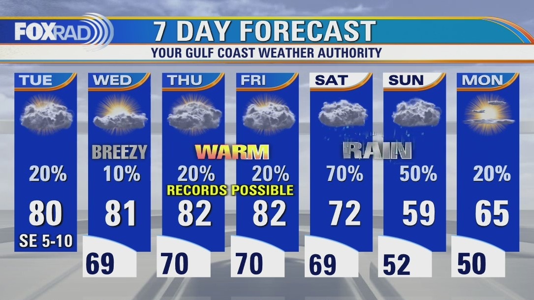
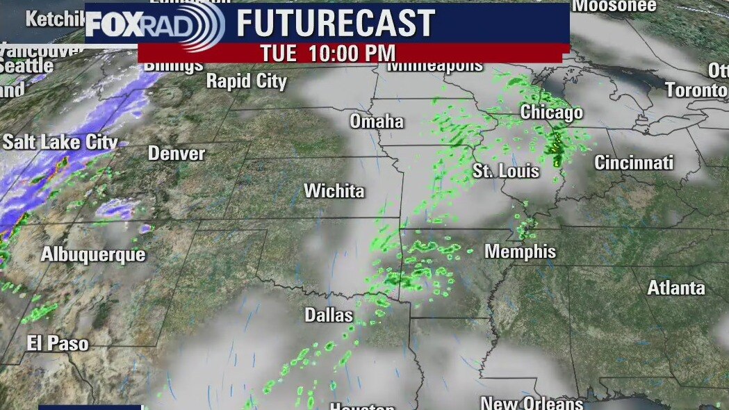
Tuesday weather forecast
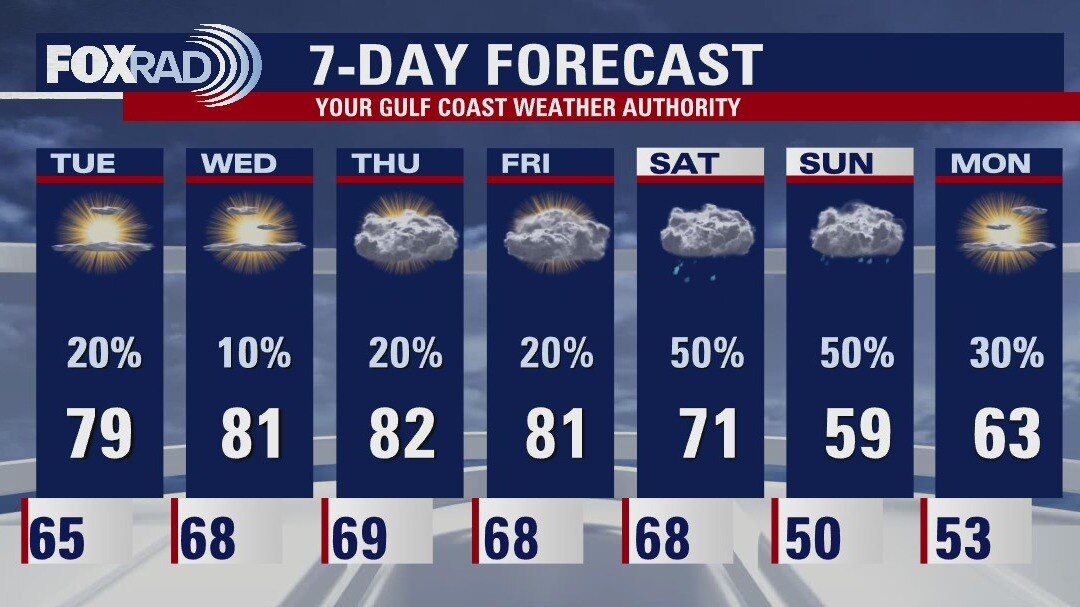
Warm, humid air is back with a vengeance and we could reach record highs each day, especially Thursday and Friday. Watch for scattered showers and a possible storm today followed by a warm, breezy Wednesday. Low 80s are on the way late this week, but that will come to an end this weekend with rainy, cooler weather.
Warm, humid air is back with a vengeance and we could reach record highs each day, especially Thursday and Friday. Watch for scattered showers and a possible storm today followed by a warm, breezy Wednesday. Low 80s are on the way late this week, but that will come to an end this weekend with rainy, cooler weather.
Monday evening weather forecast
It will get warmer over the next few days with highs back into the 80s by Wednesday. Rain chances will become more likely as we head into the weekend and that's when the temps will start to drop at least a little.
It will get warmer over the next few days with highs back into the 80s by Wednesday. Rain chances will become more likely as we head into the weekend and that's when the temps will start to drop at least a little.
Monday weather forecast
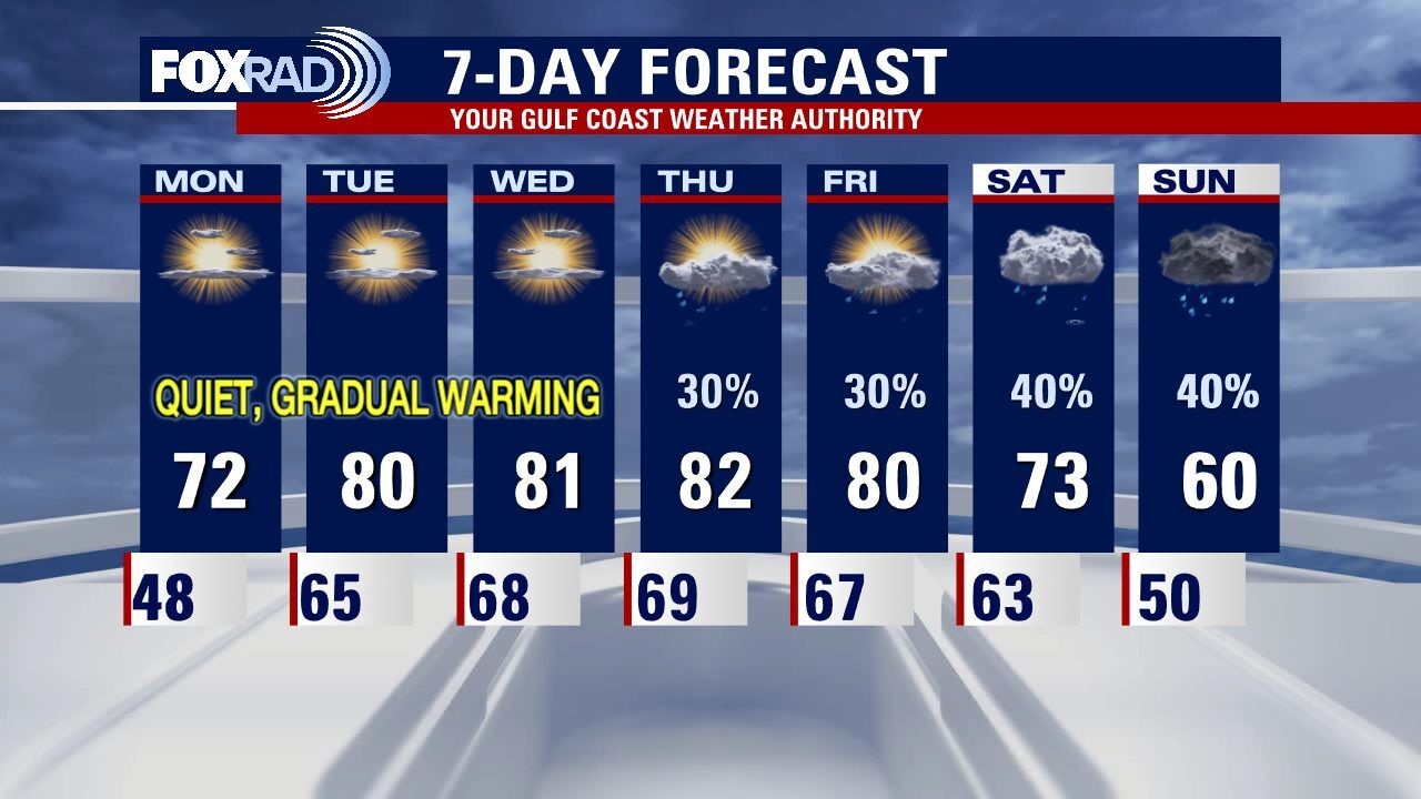
Although today will still be on the cool side, a warming trend is beginning and could take us to near records highs by mid to late this week. Watch for a few showers today with clouds and highs in the upper 60s. Much milder air will return for Tuesday through Friday with daily highs in the upper 70s and even low 80s. This upcoming weekend is looking rainy.
Although today will still be on the cool side, a warming trend is beginning and could take us to near records highs by mid to late this week. Watch for a few showers today with clouds and highs in the upper 60s. Much milder air will return for Tuesday through Friday with daily highs in the upper 70s and even low 80s. This upcoming weekend is looking rainy.
Sunday weather forecast with Meteorologist John Dawson
One more cool morning set for Monday and then warm temperatures start returning to Southeast Texas. A front should approach Houston towards the end of the week and stall before reaching the coast. That should give enough moisture for some rain but not anything too stormy is expected at this point.
One more cool morning set for Monday and then warm temperatures start returning to Southeast Texas. A front should approach Houston towards the end of the week and stall before reaching the coast. That should give enough moisture for some rain but not anything too stormy is expected at this point.
Sunday Morning Forecast with Meteorologist Lena Maria
After a chilly start to Sunday Morning, a bright but cool afternoon is on the way. Winter paid us a brief, but short-lived visit this weekend. Onshore flow returns tomorrow bringing our temperatures up near 80 degrees for several days midweek. Keeping an eye on the potential for a front toward the end of the week that would cool things down once again. Rain chances remain low, if not non-existent until then.
After a chilly start to Sunday Morning, a bright but cool afternoon is on the way. Winter paid us a brief, but short-lived visit this weekend. Onshore flow returns tomorrow bringing our temperatures up near 80 degrees for several days midweek. Keeping an eye on the potential for a front toward the end of the week that would cool things down once again. Rain chances remain low, if not non-existent until then.
Saturday Morning Forecast with Meteorologist Lena Maria Arango
This morning's front will usher in cooler weather, but not for long. Onshore flow returns quickly and we'll be back up near record warmth by the middle of next week. Temperatures will fall throughout the day on Saturday, and after a chilly start on Sunday we'll close out the weekend with abundant sunshine.
This morning's front will usher in cooler weather, but not for long. Onshore flow returns quickly and we'll be back up near record warmth by the middle of next week. Temperatures will fall throughout the day on Saturday, and after a chilly start on Sunday we'll close out the weekend with abundant sunshine.
Saturday morning weather forecast
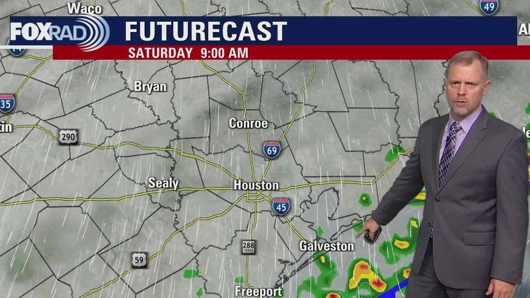
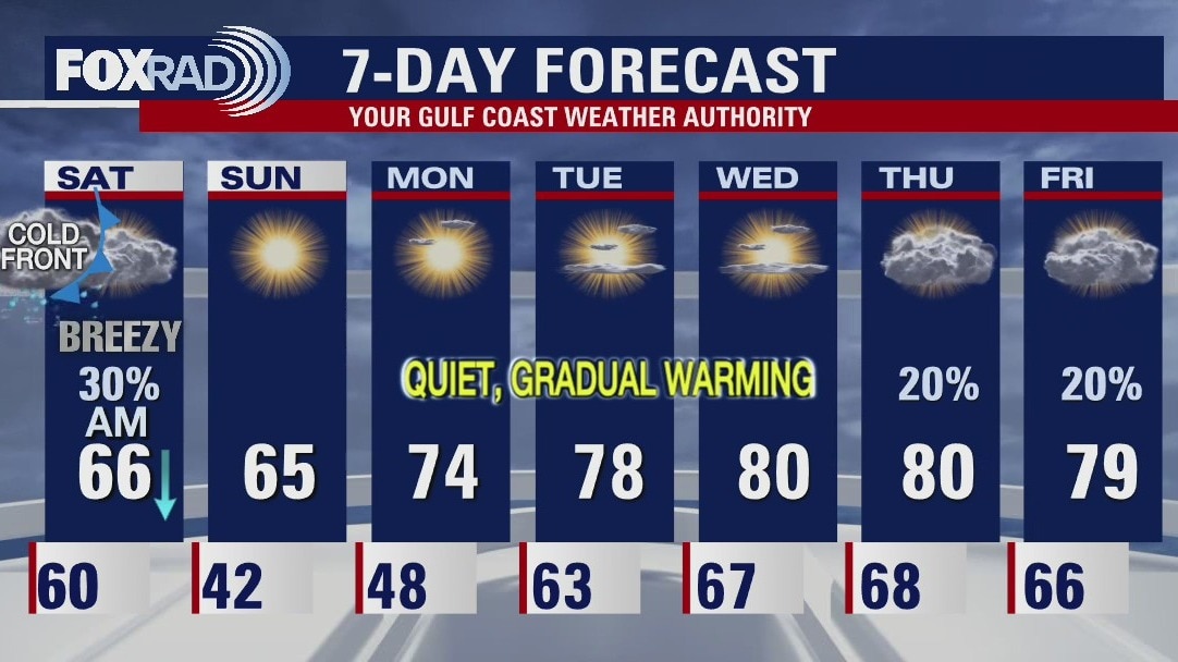
We are done with the record-high temperatures, at least for now. A cold front moves through Southeast Texas Friday night and leaves Houston with much cooler weather for the weekend. Look for a line of showers/storms as the front arrives and then a dry forecast for most of next week.
We are done with the record-high temperatures, at least for now. A cold front moves through Southeast Texas Friday night and leaves Houston with much cooler weather for the weekend. Look for a line of showers/storms as the front arrives and then a dry forecast for most of next week.
Friday evening weather forecast
We are done with the record-high temperatures, at least for now. A cold front moves through Southeast Texas Friday night and leaves Houston with much cooler weather for the weekend. Look for a line of showers/storms as the front arrives and then a dry forecast for most of next week
We are done with the record-high temperatures, at least for now. A cold front moves through Southeast Texas Friday night and leaves Houston with much cooler weather for the weekend. Look for a line of showers/storms as the front arrives and then a dry forecast for most of next week
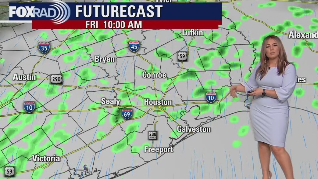
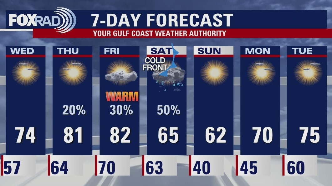
Friday weather forecast
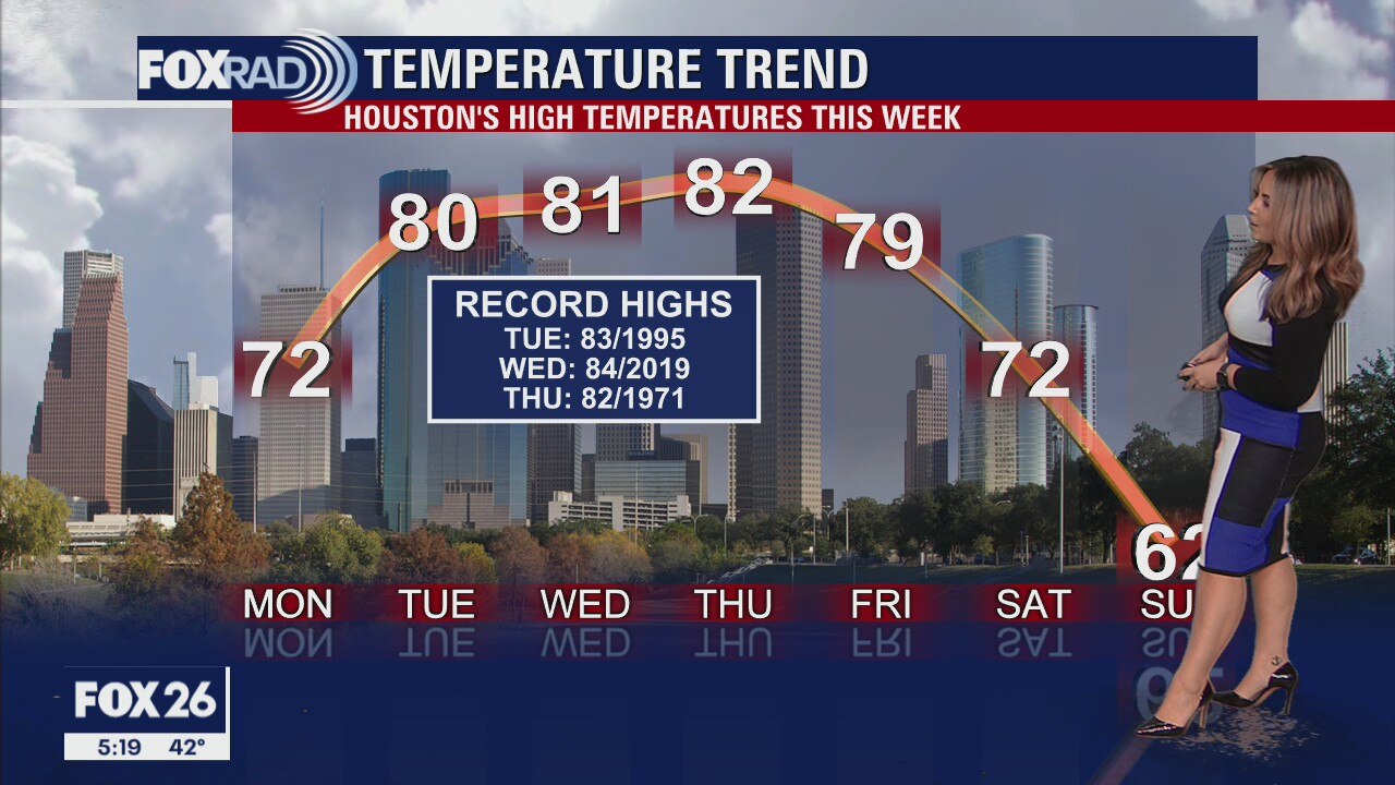
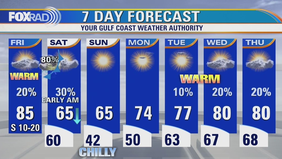
Unprecedented warmth continues today following the warmest December day in Houston's history yesterday. Records are likely to fall again today along with breezy and humid south winds. Now, an early morning cold front tomorrow will bring storms followed by much cooler air. Afternoon temps will drop between 20 and 30 degrees from today to Saturday. Cool air will be short-lived though, with highs near 80 again by Wednesday.
Unprecedented warmth continues today following the warmest December day in Houston's history yesterday. Records are likely to fall again today along with breezy and humid south winds. Now, an early morning cold front tomorrow will bring storms followed by much cooler air. Afternoon temps will drop between 20 and 30 degrees from today to Saturday. Cool air will be short-lived though, with highs near 80 again by Wednesday.
Friday morning weather forecast
Our steamy weather continues Friday before a cold front brings a temporary cool down to southeast Texas. Showers and isolated storms will occur overnight Friday into early morning Saturday. The seasonable weather is short-lived. Onshore flow returns quickly next week, and along with it -- more gulf warmth and moisture.
Our steamy weather continues Friday before a cold front brings a temporary cool down to southeast Texas. Showers and isolated storms will occur overnight Friday into early morning Saturday. The seasonable weather is short-lived. Onshore flow returns quickly next week, and along with it -- more gulf warmth and moisture.
Thursday evening weather forecast with Meteorologist Lena Maria Arango
Our steamy weather continues Friday before the cold front brings a temporary cool down to southeast Texas. Showers and isolated storms will occur overnight Friday into early morning Saturday. The seasonable weather is short-lived. Onshore flow returns quickly next week, and along with it -- more gulf warmth and moisture
Our steamy weather continues Friday before the cold front brings a temporary cool down to southeast Texas. Showers and isolated storms will occur overnight Friday into early morning Saturday. The seasonable weather is short-lived. Onshore flow returns quickly next week, and along with it -- more gulf warmth and moisture
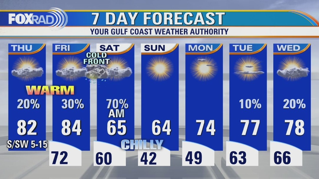
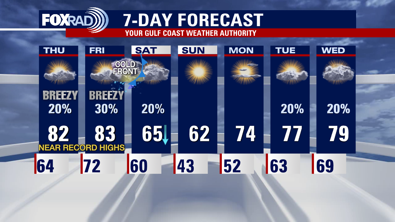
Thursday weather forecast
Record highs are likely across Texas over the next two days as we await our next cold front which is expected Saturday morning. Until then, expect highs in the low 80s today and low to mid 80s Friday. Saturday morning storms could be strong, followed by two days of cooler air and a chilly Sunday morning. Next week looks warm again.
Record highs are likely across Texas over the next two days as we await our next cold front which is expected Saturday morning. Until then, expect highs in the low 80s today and low to mid 80s Friday. Saturday morning storms could be strong, followed by two days of cooler air and a chilly Sunday morning. Next week looks warm again.
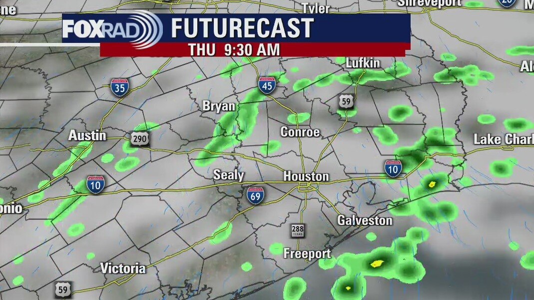
Thursday morning weather forecast
Patchy fog will be a possibility once again overnight. It'll be warm, and breezy on Thursday and Friday as we contend with record highs ahead of our next cold front. That'll bring scattered showers and storms to southeast Texas overnight Friday into Saturday morning, along with a brief cool down. But, don't get used to it -- southerly flow brings us right back up near 80 by the middle of next week! And with that, rain chances will creep back in again.
Patchy fog will be a possibility once again overnight. It'll be warm, and breezy on Thursday and Friday as we contend with record highs ahead of our next cold front. That'll bring scattered showers and storms to southeast Texas overnight Friday into Saturday morning, along with a brief cool down. But, don't get used to it -- southerly flow brings us right back up near 80 by the middle of next week! And with that, rain chances will creep back in again.
Wednesday evening weather forecast with Meteorologist Lena Maria Arango
Patchy fog will be a possibility once again overnight. It'll be warm, and breezy on Thursday and Friday as we contend with record highs ahead of our next cold front. That'll bring scattered showers and storms to southeast Texas overnight Friday into Saturday morning, along with a brief cool down. But, don't get used to it -- southerly flow brings us right back up near 80 by the middle of next week! And with that, rain chances will creep back in again.
Patchy fog will be a possibility once again overnight. It'll be warm, and breezy on Thursday and Friday as we contend with record highs ahead of our next cold front. That'll bring scattered showers and storms to southeast Texas overnight Friday into Saturday morning, along with a brief cool down. But, don't get used to it -- southerly flow brings us right back up near 80 by the middle of next week! And with that, rain chances will creep back in again.
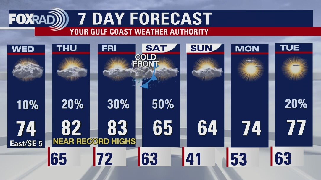
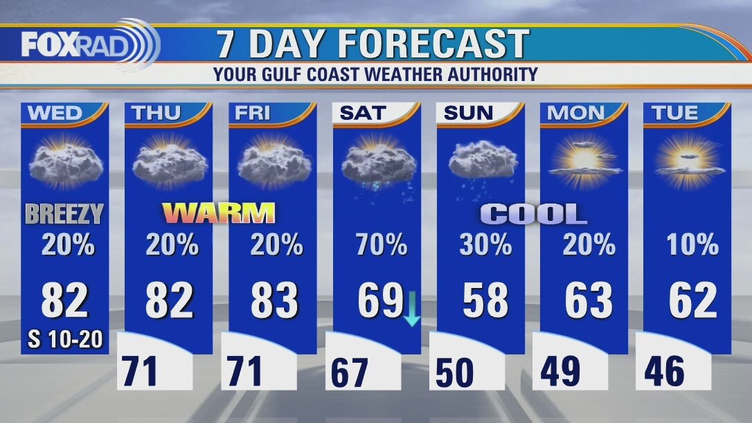
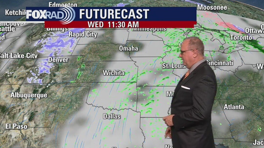
Wednesday weather forecast
After a misty and foggy morning, a warming trend begins today and could bring record highs for Thursday and Friday. A cold front is expected late Friday into Saturday and after a round of showers and storms, we'll experience a brief chill that will only last about 36 hours before mild air returns.
After a misty and foggy morning, a warming trend begins today and could bring record highs for Thursday and Friday. A cold front is expected late Friday into Saturday and after a round of showers and storms, we'll experience a brief chill that will only last about 36 hours before mild air returns.
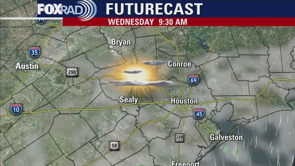
Wednesday morning weather forecast
Another cool night for Southeast Texas with lows in the 50s but the warmer weather starts returning Wednesday. Houston could see record high temperatures at the end of the week before the next cold front arrives Saturday morning. Rain chances will stay low until the front brings a line of showers/storms. A perfect end to the weekend with more cool weather to start the workweek.
Another cool night for Southeast Texas with lows in the 50s but the warmer weather starts returning Wednesday. Houston could see record high temperatures at the end of the week before the next cold front arrives Saturday morning. Rain chances will stay low until the front brings a line of showers/storms. A perfect end to the weekend with more cool weather to start the workweek.
Tuesday evening weather forecast
Another cool night for Southeast Texas with lows in the 50s but the warmer weather starts returning Wednesday. Houston could see record high temperatures at the end of the week before the next cold front arrives Saturday morning. Rain chances will stay low until the front brings a line of showers/storms. A perfect end to the weekend with more cool weather to start the workweek.
Another cool night for Southeast Texas with lows in the 50s but the warmer weather starts returning Wednesday. Houston could see record high temperatures at the end of the week before the next cold front arrives Saturday morning. Rain chances will stay low until the front brings a line of showers/storms. A perfect end to the weekend with more cool weather to start the workweek.