

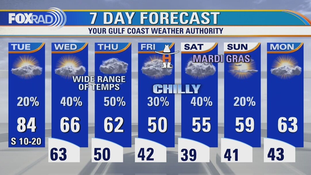
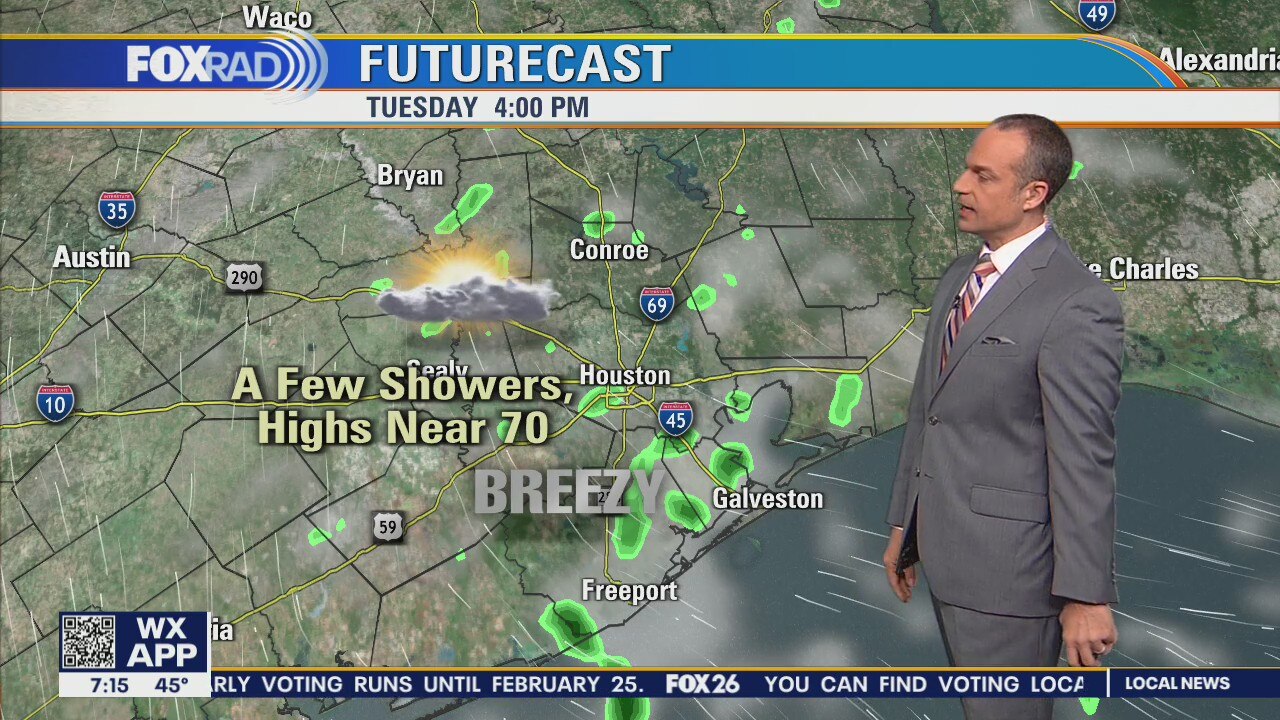
Tuesday afternoon weather forecast
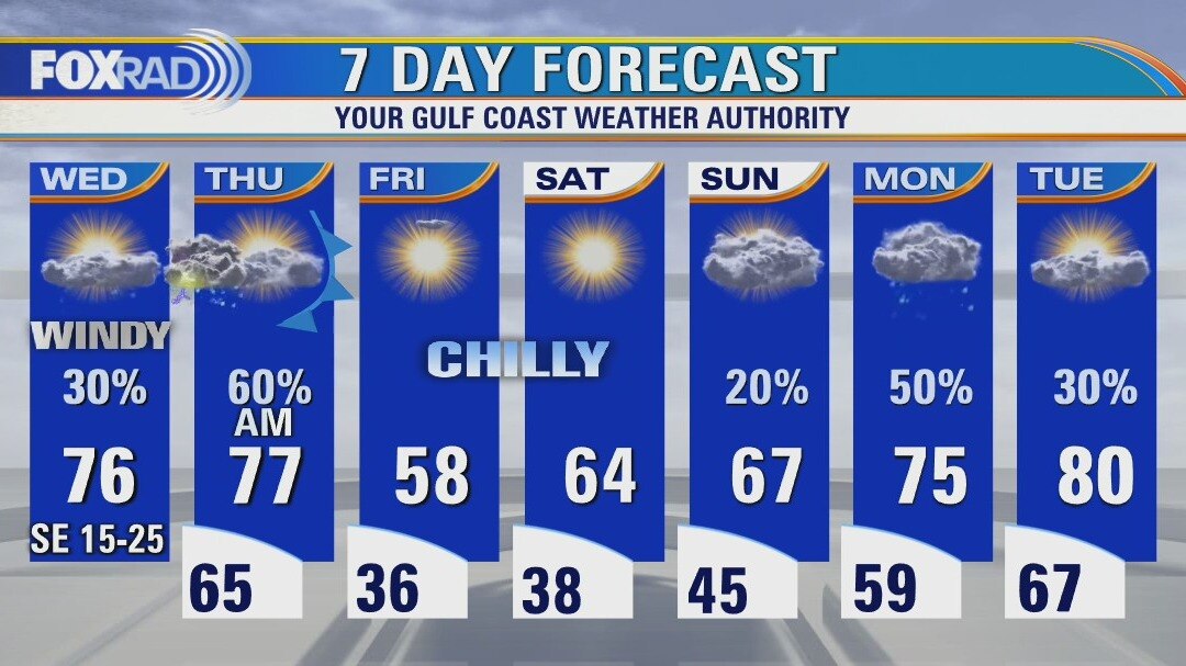
The forecast over the next few days presents a huge challenge due to a cold front that will approach our area, stall, then waver back and forth for Wednesday and Thursday. Today will be warm and breezy with highs in the 80s. Temperatures tomorrow and Thursday could be highly variable with much colder air northwest of Houston. Some of our main forecast models are differing on temperatures by 30 degrees at times, for mid-week. Finally, cold air pushes all the way through for Friday and the weekend.
The forecast over the next few days presents a huge challenge due to a cold front that will approach our area, stall, then waver back and forth for Wednesday and Thursday. Today will be warm and breezy with highs in the 80s. Temperatures tomorrow and Thursday could be highly variable with much colder air northwest of Houston. Some of our main forecast models are differing on temperatures by 30 degrees at times, for mid-week. Finally, cold air pushes all the way through for Friday and the weekend.
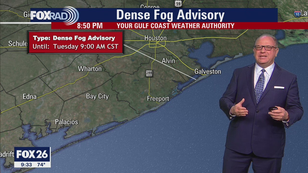
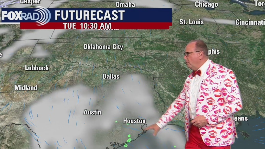
Be ready for fog Tuesday morning!
There's a dense fog advisory until 9 a.m. Tuesday. It's not going to be a pretty week as far as our weather goes. There's a daily chance for rain. A front will stall nearby, and it will get cooler by the end of the workweek. Sounds just about normal for this time in February.
There's a dense fog advisory until 9 a.m. Tuesday. It's not going to be a pretty week as far as our weather goes. There's a daily chance for rain. A front will stall nearby, and it will get cooler by the end of the workweek. Sounds just about normal for this time in February.
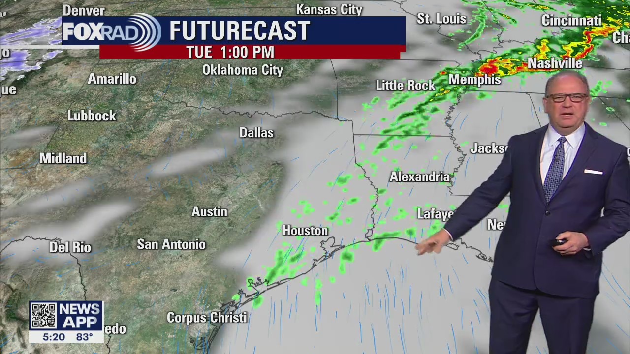
Daily chance for rain this week
It's not going to be a pretty week as far as our weather goes. There's a daily chance for rain. A front will stall nearby, and it will get cooler by the end of the workweek. Sounds just about normal for this time in February.
It's not going to be a pretty week as far as our weather goes. There's a daily chance for rain. A front will stall nearby, and it will get cooler by the end of the workweek. Sounds just about normal for this time in February.
Monday afternoon weather forecast
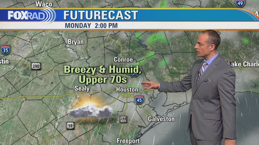
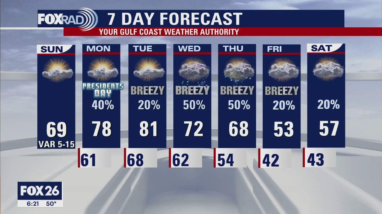
What a muggy, spring-like start to an interesting and active weather week. Look for highs today and tomorrow to reach the upper 70s and low 80s with breezy south winds and scattered light rain. A cold front will approach and stall Wednesday and Thursday followed by cold, windy and wet weather (as usual) for trail riders, the rodeo parade and Go Texan Day.
What a muggy, spring-like start to an interesting and active weather week. Look for highs today and tomorrow to reach the upper 70s and low 80s with breezy south winds and scattered light rain. A cold front will approach and stall Wednesday and Thursday followed by cold, windy and wet weather (as usual) for trail riders, the rodeo parade and Go Texan Day.
Sunday Morning Forecast with Meteorologist Lena Maria
The weekend ends on a mostly dry, though mostly cloudy note with some PM drizzle or mist possible. Then temperatures and humidity will be on the rise. Look out for patchy fog in the mornings at the start of the week, as a warm front lifts north off the Gulf launching our temperatures to near 80. Daily chances for isolated showers and storms linger throughout the week due to a midweek cold front that stalls, though accumulations look to be light and severe weather is not expected at this time. It will be breezy all week long, and sunshine will be hard to come by.
The weekend ends on a mostly dry, though mostly cloudy note with some PM drizzle or mist possible. Then temperatures and humidity will be on the rise. Look out for patchy fog in the mornings at the start of the week, as a warm front lifts north off the Gulf launching our temperatures to near 80. Daily chances for isolated showers and storms linger throughout the week due to a midweek cold front that stalls, though accumulations look to be light and severe weather is not expected at this time. It will be breezy all week long, and sunshine will be hard to come by.
Saturday night leading into Sunday weather forecast
It will be warmer over the next several days, but rain chances will be back by Monday. Several small systems will move across SE Texas bring some scattered showers and a front will arrive and stall by Wednesday. It means daily rain chances.
It will be warmer over the next several days, but rain chances will be back by Monday. Several small systems will move across SE Texas bring some scattered showers and a front will arrive and stall by Wednesday. It means daily rain chances.
Saturday Morning Forecast with Meteorologist Lena Maria
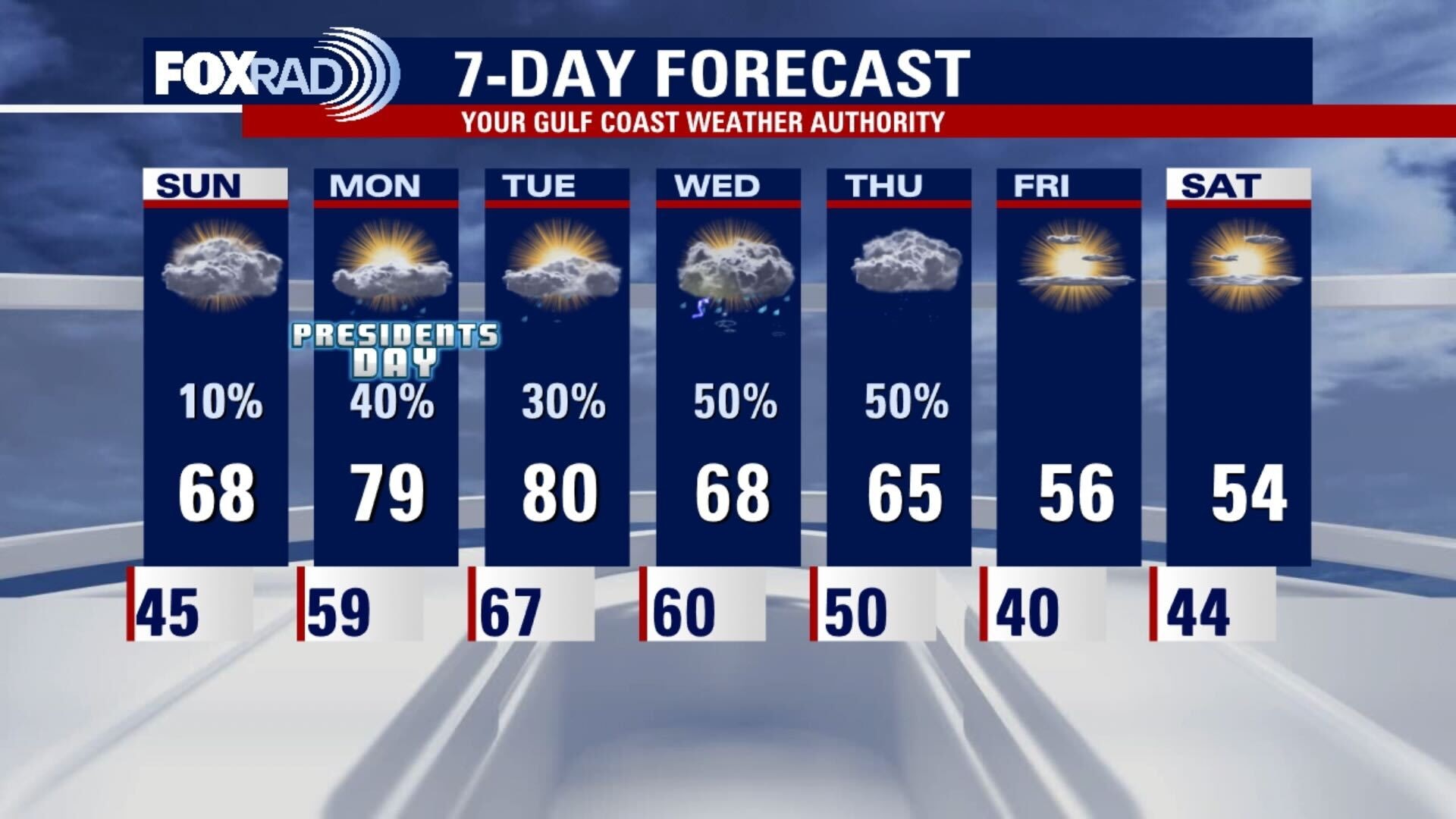
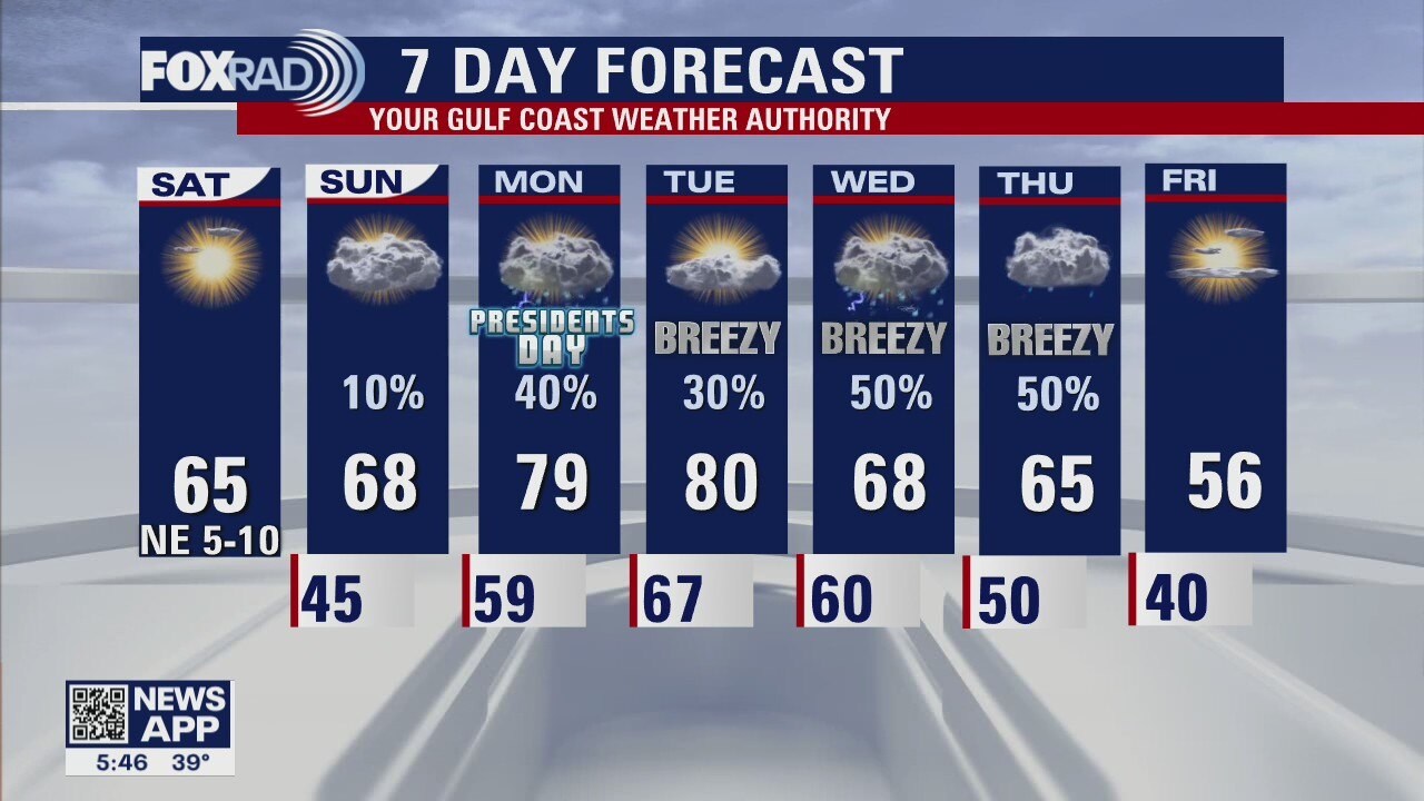
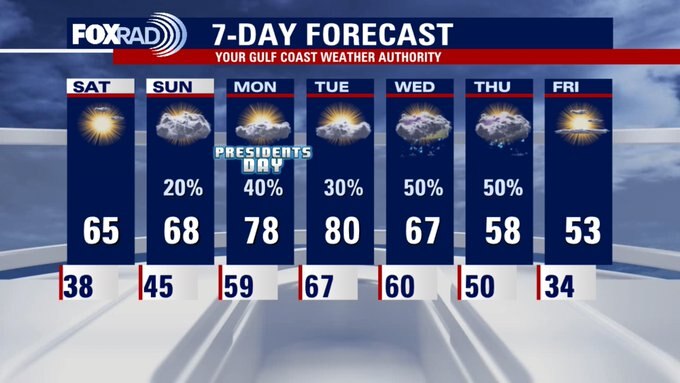
The weekend is looking nice, with Saturday being the sunnier of the two days but Sunday being the warmer of the two days. Aside from a sprinkle on Sunday, we stay dry until Monday. Next week starts warm and humid, and a series of disturbances and fronts keep rain chances a regularity throughout the week. Sunshine will be hard to come by until Friday, with breezy conditions and mostly cloudy skies.
The weekend is looking nice, with Saturday being the sunnier of the two days but Sunday being the warmer of the two days. Aside from a sprinkle on Sunday, we stay dry until Monday. Next week starts warm and humid, and a series of disturbances and fronts keep rain chances a regularity throughout the week. Sunshine will be hard to come by until Friday, with breezy conditions and mostly cloudy skies.

Friday night leading into Saturday morning weather forecast
Saturday will start off cold, but highs will reach back into the 60s by the afternoon. The coming week looks unsettled with daily rain chances and warm temps at least through the middle of the week. It will cool down and dry up by Friday.
Saturday will start off cold, but highs will reach back into the 60s by the afternoon. The coming week looks unsettled with daily rain chances and warm temps at least through the middle of the week. It will cool down and dry up by Friday.
Friday evening weather forecast with Chief Meteorologist Dr. Jim Siebert
Saturday will start off cold, but highs will reach back into the 60s by the afternoon. The coming week looks unsettled with daily rain chances and warm temps at least through the middle of the week. It will cool down and dry up by Friday.
Saturday will start off cold, but highs will reach back into the 60s by the afternoon. The coming week looks unsettled with daily rain chances and warm temps at least through the middle of the week. It will cool down and dry up by Friday.
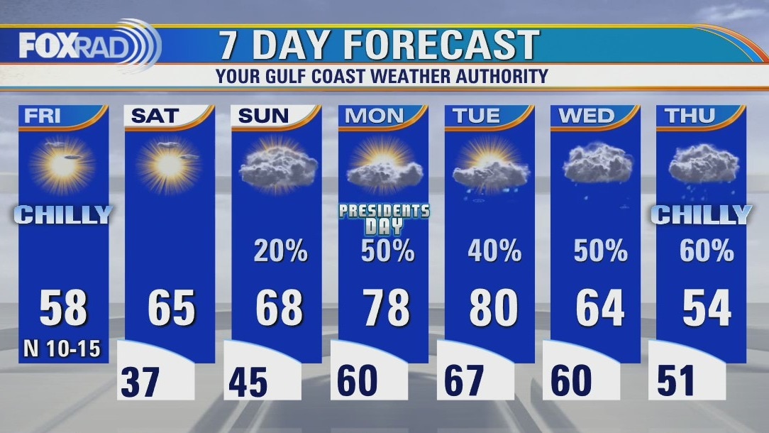
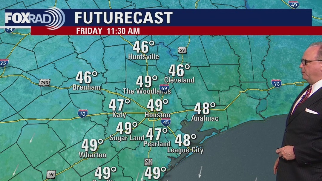
Friday afternoon weather forecast
What a weather roller-coaster! After hitting highs in the low to middle 80s on Thursday, temperatures dropped to the mid-30s this morning and will likely only reach the upper 50s today. We will have plenty of sunshine today and Saturday. Showers should return by Sunday evening and each day next week will bring a good chance for showers. We'll once again have ups and downs with highs near 80 on Tuesday to blustery conditions by late week.
What a weather roller-coaster! After hitting highs in the low to middle 80s on Thursday, temperatures dropped to the mid-30s this morning and will likely only reach the upper 50s today. We will have plenty of sunshine today and Saturday. Showers should return by Sunday evening and each day next week will bring a good chance for showers. We'll once again have ups and downs with highs near 80 on Tuesday to blustery conditions by late week.
Friday morning weather forecast
It's going to be much cooler on Friday with lows in the 30s and highs in the 50s. Saturday starts off chilly but will be a little warmer by the afternoon. The coming week looks a little unsettled and somewhat soggy with more mild weather.
It's going to be much cooler on Friday with lows in the 30s and highs in the 50s. Saturday starts off chilly but will be a little warmer by the afternoon. The coming week looks a little unsettled and somewhat soggy with more mild weather.
Thursday evening weather forecast with Chief Meteorologist Dr. Jim Siebert
It's going to be much cooler on Friday with lows in the 30s and highs in the 50s. Saturday starts off chilly, but will be a little warmer by the afternoon. The coming week looks a little unsettled and somewhat soggy with more mild weather.
It's going to be much cooler on Friday with lows in the 30s and highs in the 50s. Saturday starts off chilly, but will be a little warmer by the afternoon. The coming week looks a little unsettled and somewhat soggy with more mild weather.
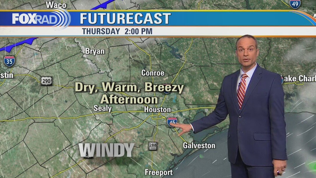
Thursday afternoon weather forecast
Today's weather is broken into three parts: morning rain and humidity, afternoon sun and dry air, then a plunge of cold air this evening. It will also be windy with warm winds turning to cold winds late today. Lows could drop into the mid 30s overnight with brisk weather through Sunday morning. Next week looks unsettled with showers and storms possible each day.
Today's weather is broken into three parts: morning rain and humidity, afternoon sun and dry air, then a plunge of cold air this evening. It will also be windy with warm winds turning to cold winds late today. Lows could drop into the mid 30s overnight with brisk weather through Sunday morning. Next week looks unsettled with showers and storms possible each day.
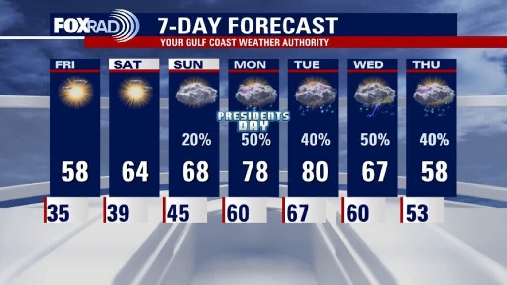
Thursday morning weather forecast
A front arrives on Thursday and we will feel it by the afternoon. Lows will dip into the 30s both on Friday and Saturday, but the afternoons will warm a little more each day. Presidents' Day will have a few scattered showers and warm temps.
A front arrives on Thursday and we will feel it by the afternoon. Lows will dip into the 30s both on Friday and Saturday, but the afternoons will warm a little more each day. Presidents' Day will have a few scattered showers and warm temps.

Wednesday evening weather forecast with Chief Meteorologist Dr. Jim Siebert
A front arrives on Thursday and we will feel it by the afternoon. Lows will dip into the 30s both on Friday and Saturday, but the afternoons will warm a little more each day. Presidents' Day will have a few scattered showers and warm temps.
A front arrives on Thursday and we will feel it by the afternoon. Lows will dip into the 30s both on Friday and Saturday, but the afternoons will warm a little more each day. Presidents' Day will have a few scattered showers and warm temps.
Wednesday afternoon weather forecast
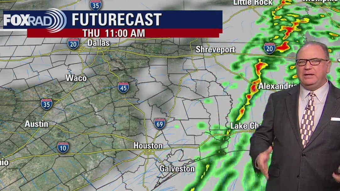
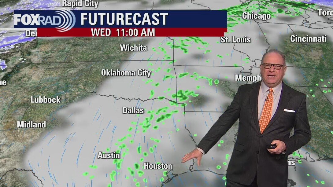
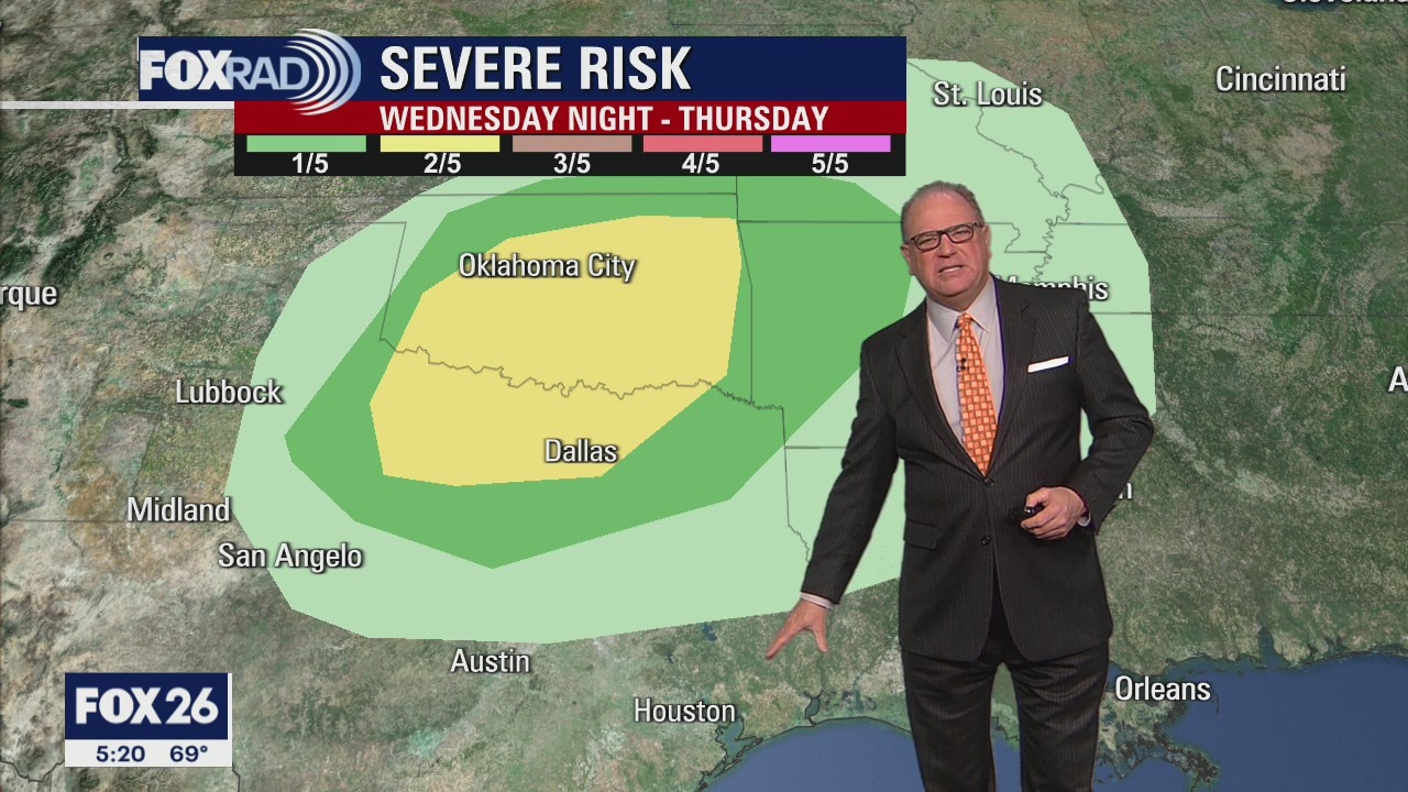
Hold on to your hats, it's going to be a windy Wednesday. Mild and humid southeast breezes will bring highs in the mid-70s and a few passing showers. A front is expected Thursday with the best chance for storms in the early morning. Cold air will move in Thursday night through the weekend with lows back in the 30s. Highs could reach 80 degrees by the middle of next week.
Hold on to your hats, it's going to be a windy Wednesday. Mild and humid southeast breezes will bring highs in the mid-70s and a few passing showers. A front is expected Thursday with the best chance for storms in the early morning. Cold air will move in Thursday night through the weekend with lows back in the 30s. Highs could reach 80 degrees by the middle of next week.
Wednesday morning weather forecast
It will be very nice on Wednesday until the next cold front arrives. There will be some showers and storms early Thursday and things will cool down for a couple of days. The weekend will be cool in the mornings with sunny skies.
It will be very nice on Wednesday until the next cold front arrives. There will be some showers and storms early Thursday and things will cool down for a couple of days. The weekend will be cool in the mornings with sunny skies.
Tuesday Evening Weather Forecast
Chief Meteorologist Dr. Jim Siebert has the latest on weather conditions expected this week.
Chief Meteorologist Dr. Jim Siebert has the latest on weather conditions expected this week.
Mild, more humid air coming
Today marks one year since the catastrophic loss of power and water last February as temperatures plunged into the teens. Fortunately, nothing like that is headed our way any time soon. Look for increasing southeast winds today and tomorrow which will bring mild, more humid air and a few light showers. A cold front on Thursday could bring a round of storms followed by more chilly air by Friday.
Today marks one year since the catastrophic loss of power and water last February as temperatures plunged into the teens. Fortunately, nothing like that is headed our way any time soon. Look for increasing southeast winds today and tomorrow which will bring mild, more humid air and a few light showers. A cold front on Thursday could bring a round of storms followed by more chilly air by Friday.
Tuesday morning weather forecast
It will be very nice on Tuesday and Wednesday until the next cold front arrives. There will be some showers and storms early Thursday and things will cool down for a couple of days. The weekend will be cool in the mornings with sunny skies.
It will be very nice on Tuesday and Wednesday until the next cold front arrives. There will be some showers and storms early Thursday and things will cool down for a couple of days. The weekend will be cool in the mornings with sunny skies.