

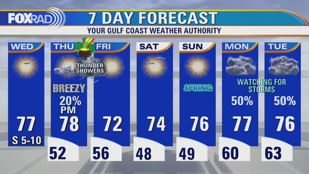
Wednesday afternoon weather forecast
Wednesday will be a beauty, shower chances increase late afternoon on St. Patrick's Day. A cool front brings non-severe thundershowers in the overnight hours of Thursday into Friday with cool, dry pleasant weather to follow leading into the weekend. Monday and Tuesday of next week have the potential to be a bit active, so we're watching trends closely for now.
Wednesday will be a beauty, shower chances increase late afternoon on St. Patrick's Day. A cool front brings non-severe thundershowers in the overnight hours of Thursday into Friday with cool, dry pleasant weather to follow leading into the weekend. Monday and Tuesday of next week have the potential to be a bit active, so we're watching trends closely for now.
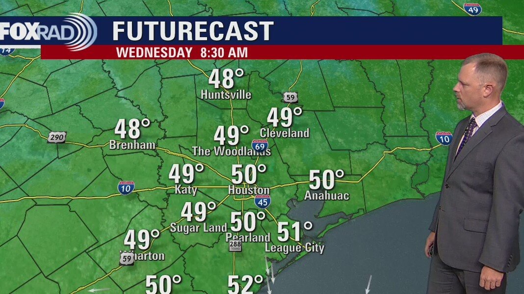
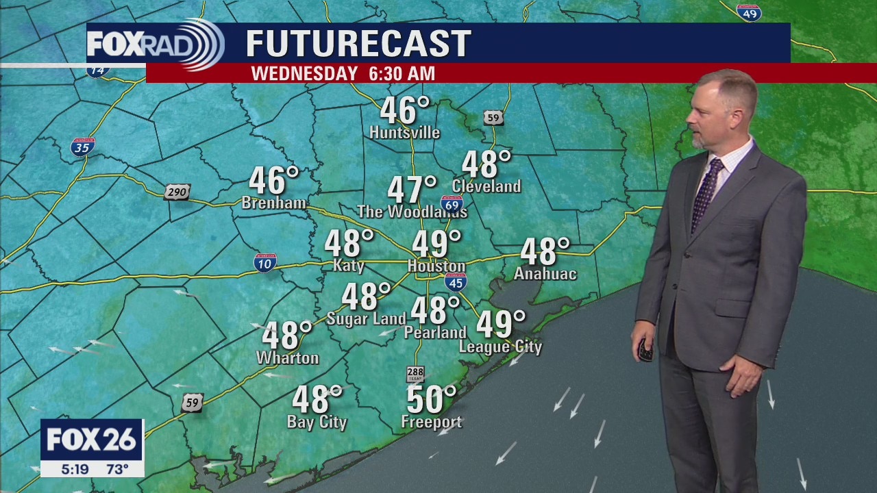
Wednesday morning weather forecast
Southeast Texas will see great weather during the next several days, perfect for those on Spring Break. There is a good chance for some showers around Houston on Thursday night. This rain should not be too stormy, 50% chance for showers. The weekend also looking great for now, we'll be monitoring the next system for severe storms as it arrives at the beginning of the week.
Southeast Texas will see great weather during the next several days, perfect for those on Spring Break. There is a good chance for some showers around Houston on Thursday night. This rain should not be too stormy, 50% chance for showers. The weekend also looking great for now, we'll be monitoring the next system for severe storms as it arrives at the beginning of the week.
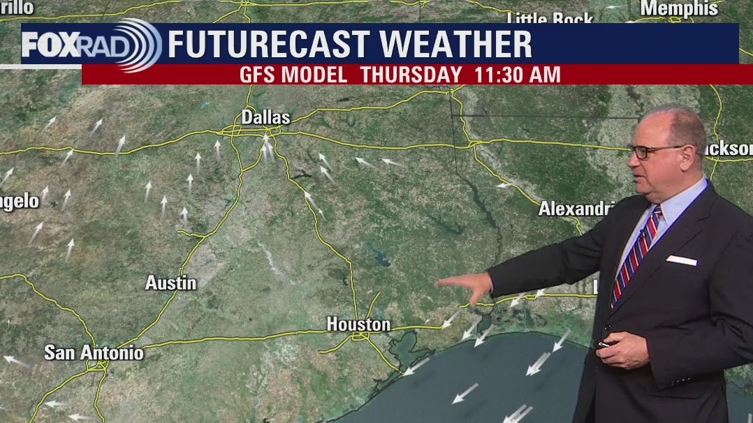
Tuesday Evening Weather Forecast
Southeast Texas will see great weather during the next several days, perfect for those on Spring Break. There is a good chance for some showers around Houston on Thursday night. This rain should not be too stormy, 50% chances for showers. The weekend also looking great for now, we'll be monitoring the next system for severe storms as it arrives at the beginning of the week.
Southeast Texas will see great weather during the next several days, perfect for those on Spring Break. There is a good chance for some showers around Houston on Thursday night. This rain should not be too stormy, 50% chances for showers. The weekend also looking great for now, we'll be monitoring the next system for severe storms as it arrives at the beginning of the week.
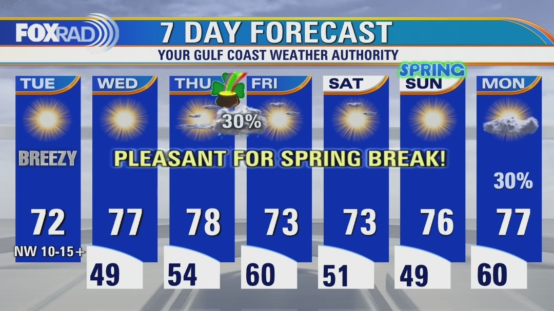
Tuesday afternoon weather forecast
The action is over, and the rest of Spring Break looks fairly quiet. Midweek will be warmer, with daytime highs near 80 degrees. A weak front with limited moisture will bring us a chance for some showers Thursday evening. But, on the other side of that St. Patrick's Day rainbow is another pot of weather gold for the weekend!
The action is over, and the rest of Spring Break looks fairly quiet. Midweek will be warmer, with daytime highs near 80 degrees. A weak front with limited moisture will bring us a chance for some showers Thursday evening. But, on the other side of that St. Patrick's Day rainbow is another pot of weather gold for the weekend!

Tuesday morning weather forecast
Storms move through the Houston area Monday night as a cold front tracks across southeast Texas. The storms will end by sunrise on Tuesday as the front moves off the coast. The rest of the week look great for outdoor activities. Looks like a great week to be on spring break!
Storms move through the Houston area Monday night as a cold front tracks across southeast Texas. The storms will end by sunrise on Tuesday as the front moves off the coast. The rest of the week look great for outdoor activities. Looks like a great week to be on spring break!
Monday evening weather forecast
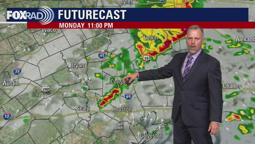
Look for a line of storms to move through southeast Texas Monday night. There could be some gusty winds, hail, and an isolated tornado as a front arrives in the Houston area. Storms will clear out quickly and the rest of the week looks great for Spring Break!
Look for a line of storms to move through southeast Texas Monday night. There could be some gusty winds, hail, and an isolated tornado as a front arrives in the Houston area. Storms will clear out quickly and the rest of the week looks great for Spring Break!


Monday evening weather forecast
Look for a line of storms to move through southeast Texas Monday night. There could be some gusty winds, hail, and an isolated tornado as a front arrives in the Houston area. Storms will clear out quickly and the rest of the week looks great for Spring Break!
Look for a line of storms to move through southeast Texas Monday night. There could be some gusty winds, hail, and an isolated tornado as a front arrives in the Houston area. Storms will clear out quickly and the rest of the week looks great for Spring Break!
Monday afternoon weather forecast
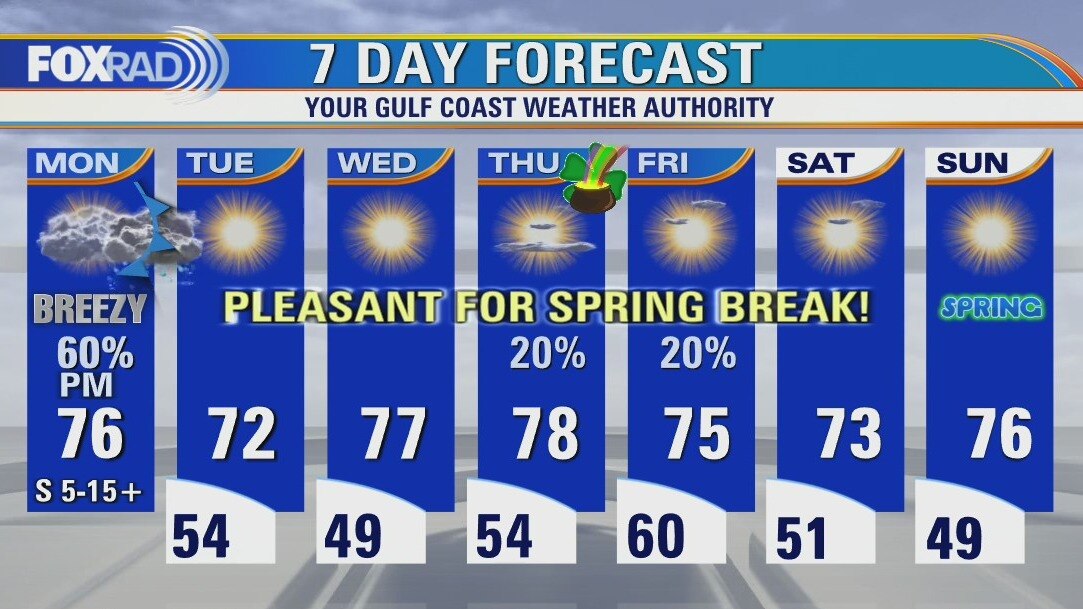
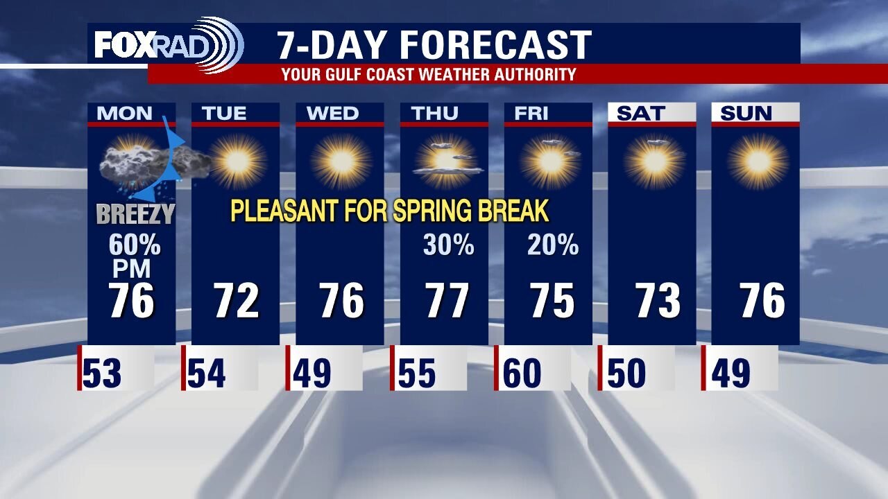
Today will be warm, and muggy with a modest south breeze and partial sunshine. Light, brief showers are possible throughout the day. A strong front arrives late tonight, with a marginal risk for severe weather. The remainder of spring break looks warm and quiet, aside from a weak quick moving front overnight Thursday into Friday. Spring officially begins Sunday March 20!
Today will be warm, and muggy with a modest south breeze and partial sunshine. Light, brief showers are possible throughout the day. A strong front arrives late tonight, with a marginal risk for severe weather. The remainder of spring break looks warm and quiet, aside from a weak quick moving front overnight Thursday into Friday. Spring officially begins Sunday March 20!
Sunday leading into Monday morning weather forecast
A couple of fronts will bring some rain chances this week but those on spring break should not be too concerned. The first opportunity will be Monday night. There could be a few quick strong storms as the front moves through. Timing right now on the second front brings some rain possibilities Thursday evening. Tuesday and Wednesday look near perfect for southeast Texas in March.
A couple of fronts will bring some rain chances this week but those on spring break should not be too concerned. The first opportunity will be Monday night. There could be a few quick strong storms as the front moves through. Timing right now on the second front brings some rain possibilities Thursday evening. Tuesday and Wednesday look near perfect for southeast Texas in March.
Sunday Morning Forecast with Meteorologist Lena Maria
If you're recovering from the lost sleep, the weather will be kind to you today! Another sunny, dry afternoon with highs in the mid 60s. We'll be warm and mainly dry for spring break, but we do have a potent cold front on the way overnight Monday-Tuesday with a marginal risk for severe weather. Be sure to have multiple ways to receive alerts, should they need to be issued.
If you're recovering from the lost sleep, the weather will be kind to you today! Another sunny, dry afternoon with highs in the mid 60s. We'll be warm and mainly dry for spring break, but we do have a potent cold front on the way overnight Monday-Tuesday with a marginal risk for severe weather. Be sure to have multiple ways to receive alerts, should they need to be issued.
Saturday night leading into Sunday weather forecast with Meteorologist John Dawson
Clear and cool weather to finish the weekend in Southeast Texas. A front late on Monday will bring a brief opportunity for showers/storms that evening. Most of next week is looking great for outdoor activities, great for those on Spring Break.
Clear and cool weather to finish the weekend in Southeast Texas. A front late on Monday will bring a brief opportunity for showers/storms that evening. Most of next week is looking great for outdoor activities, great for those on Spring Break.
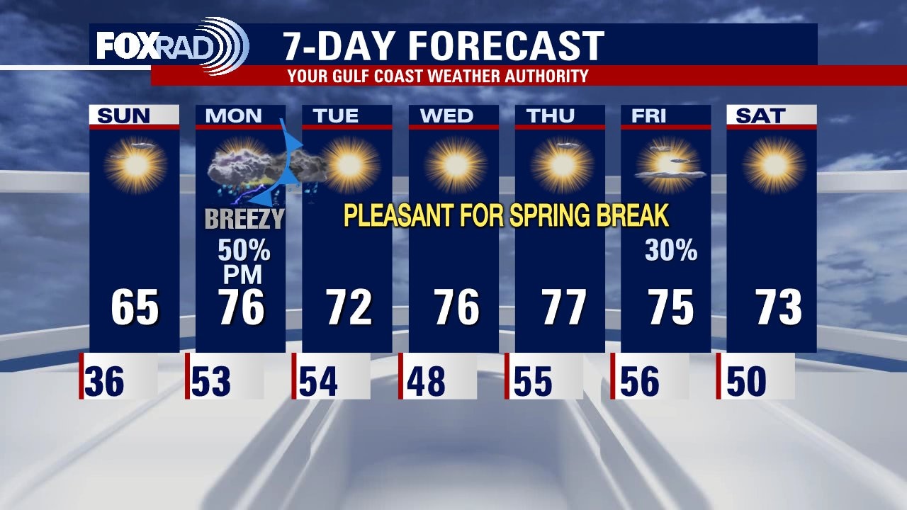
Saturday Morning Forecast with Meteorologist Lena Maria
The weekend will be chilly, but sunny and dry. Temperatures quickly climb back into the 70s by Monday when our next front looks to arrive. Notice, though it is a cold front our temperatures stay in the 70s throughout Spring Break. This air mass comes from the Pacific -- not Canada so, weather locally is looking pleasant overall. Look out for scattered showers and storms mainly Sunday afternoon and evening, and it'll be breezy but out of the south. Otherwise, rain chances are minimal but another front may arrive late week.
The weekend will be chilly, but sunny and dry. Temperatures quickly climb back into the 70s by Monday when our next front looks to arrive. Notice, though it is a cold front our temperatures stay in the 70s throughout Spring Break. This air mass comes from the Pacific -- not Canada so, weather locally is looking pleasant overall. Look out for scattered showers and storms mainly Sunday afternoon and evening, and it'll be breezy but out of the south. Otherwise, rain chances are minimal but another front may arrive late week.
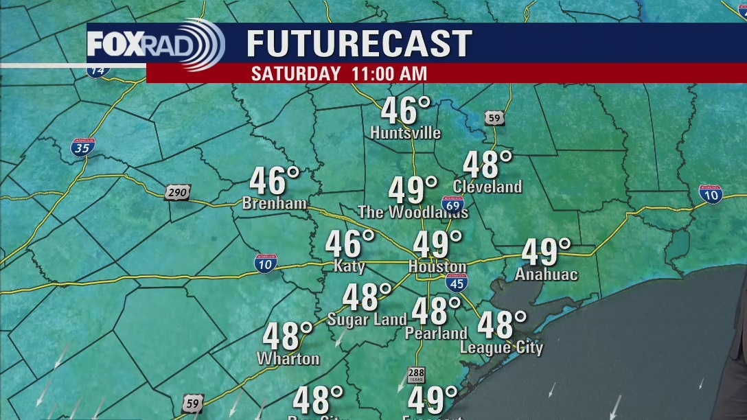
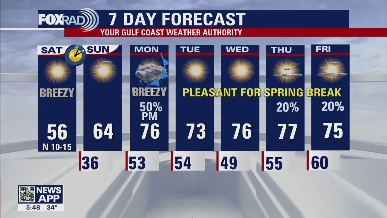
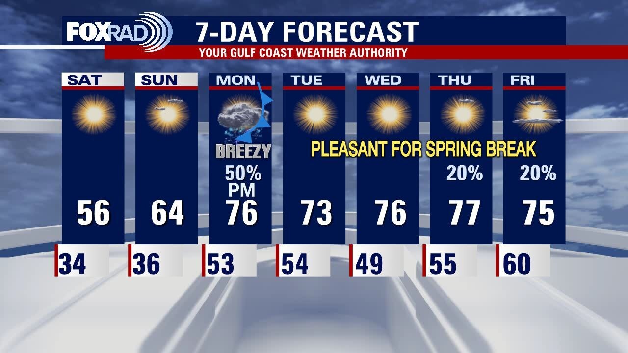
Saturday morning weather forecast
The weekend mornings look cold in Houston but clear skies should allow for some outdoor activities in the afternoons. Spring Break starts with some rain but the rest of the week looks pretty good for all those out of school looking for some fun outside.
The weekend mornings look cold in Houston but clear skies should allow for some outdoor activities in the afternoons. Spring Break starts with some rain but the rest of the week looks pretty good for all those out of school looking for some fun outside.
Friday evening weather forecast with Meteorologist John Dawson
The weekend mornings look cold in Houston but clear skies should allow for some outdoor activities in the afternoons. Spring Break starts with some rain but the rest of the week looks pretty good for all those out of school looking for some fun outside.
The weekend mornings look cold in Houston but clear skies should allow for some outdoor activities in the afternoons. Spring Break starts with some rain but the rest of the week looks pretty good for all those out of school looking for some fun outside.
Cold front moving in today
Brace yourself for big weather changes as a strong late-season cold front moves in. A wind advisory is in effect until noon Saturday and gusty winds will kick in beginning midday today with gusts in excess of 35 mph possible. Prepare for low temps close to freezing this weekend followed by sunny and dry days. Most of spring break looks nice and mild.
Brace yourself for big weather changes as a strong late-season cold front moves in. A wind advisory is in effect until noon Saturday and gusty winds will kick in beginning midday today with gusts in excess of 35 mph possible. Prepare for low temps close to freezing this weekend followed by sunny and dry days. Most of spring break looks nice and mild.
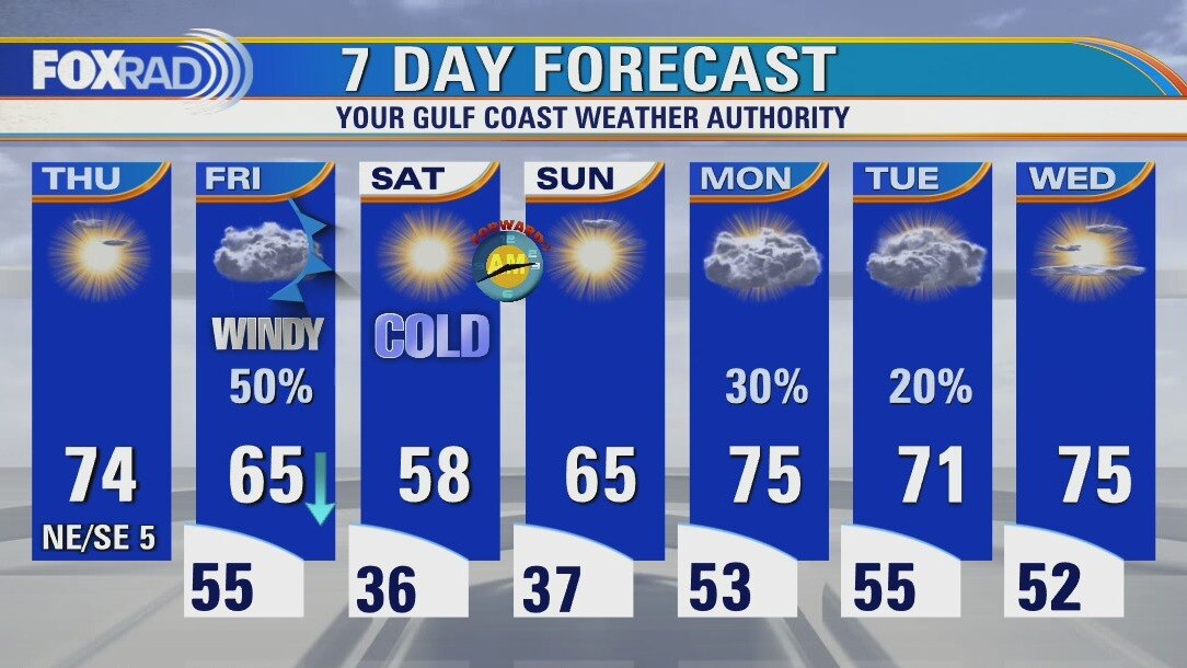
Friday morning weather forecast
The temps will warm on Wednesday and Thursday looks great. A strong cold front will arrive on Friday bringing a quick chance for rain and cool temps heading into the weekend. Some areas will be close to a light freeze early Saturday morning.
The temps will warm on Wednesday and Thursday looks great. A strong cold front will arrive on Friday bringing a quick chance for rain and cool temps heading into the weekend. Some areas will be close to a light freeze early Saturday morning.
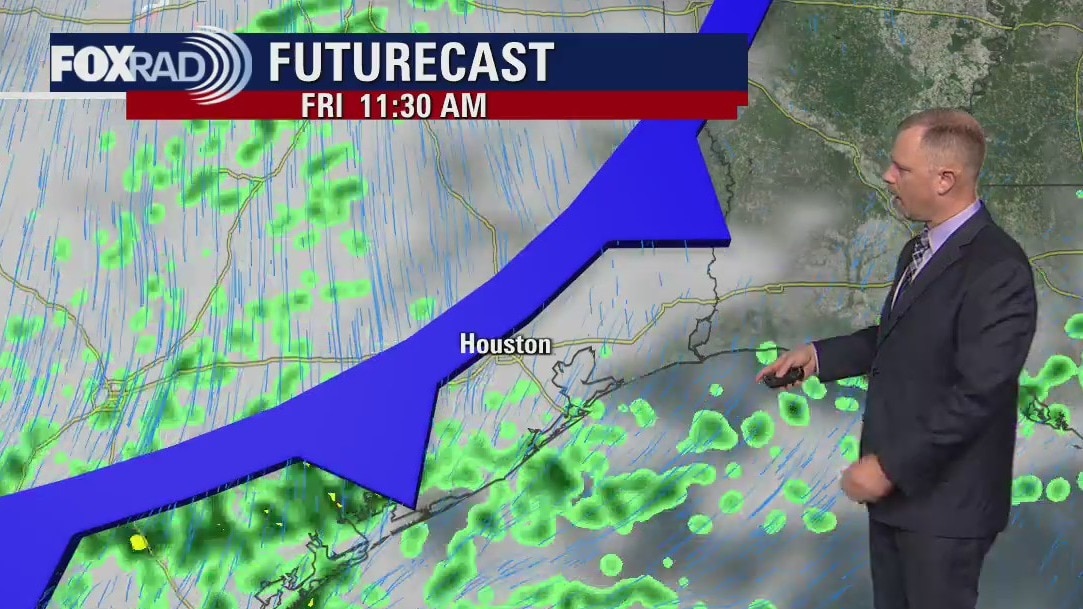
Thursday evening weather forecast
A Friday cold front brings big changes to Southeast Texas. Look for the front to arrive in downtown Houston around noon with some rain chances most of the day. Windy and cold in the afternoon with temperatures falling into the 40s. It will be near freezing on Saturday morning but plan for clear skies most of the weekend.
A Friday cold front brings big changes to Southeast Texas. Look for the front to arrive in downtown Houston around noon with some rain chances most of the day. Windy and cold in the afternoon with temperatures falling into the 40s. It will be near freezing on Saturday morning but plan for clear skies most of the weekend.
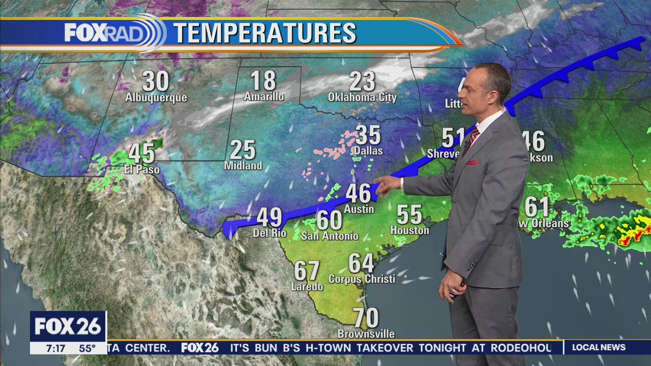
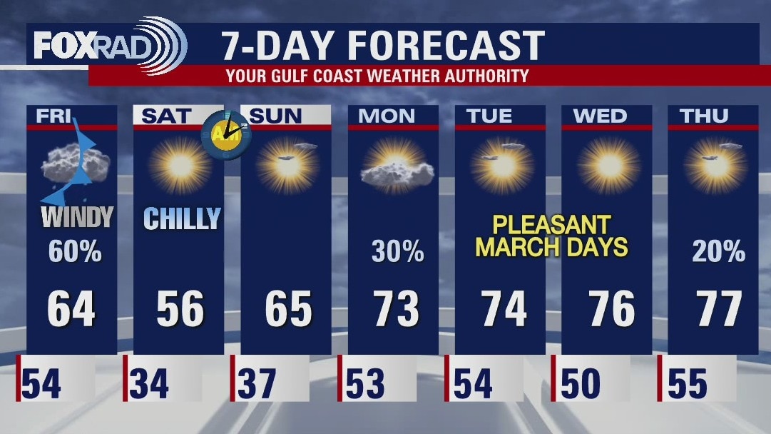
Thursday afternoon weather forecast
Enjoy today's quiet, mild weather because an unusually strong late-season cold front is on the way Friday. A wind advisory is in effect from 11 a.m. Friday through noon Saturday as cold north winds could gust above 35 mph. Expect cold nights this weekend with lows in the 30s. Spring break is shaping up to be much milder next week.
Enjoy today's quiet, mild weather because an unusually strong late-season cold front is on the way Friday. A wind advisory is in effect from 11 a.m. Friday through noon Saturday as cold north winds could gust above 35 mph. Expect cold nights this weekend with lows in the 30s. Spring break is shaping up to be much milder next week.
Thursday morning weather forecast
Thursday is looking great. A strong cold front will arrive on Friday bringing a quick chance for rain and cool temps heading into the weekend. Some areas will be close to a light freeze early Saturday morning.
Thursday is looking great. A strong cold front will arrive on Friday bringing a quick chance for rain and cool temps heading into the weekend. Some areas will be close to a light freeze early Saturday morning.

Wednesday evening weather forecast with Chief Meteorologist Dr. Jim Siebert
Thursday looks very nice with sunny skies and highs in the 70s. A strong front will arrive on Friday to cool things down into the weekend, but the coming week will rebound with highs in the 70s again by Monday.
Thursday looks very nice with sunny skies and highs in the 70s. A strong front will arrive on Friday to cool things down into the weekend, but the coming week will rebound with highs in the 70s again by Monday.