

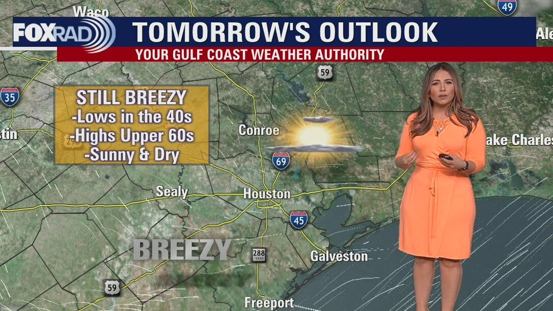
Wednesday morning weather forecast
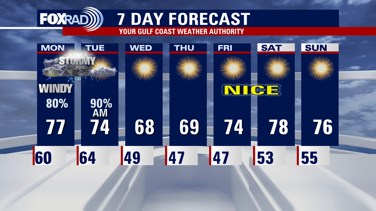
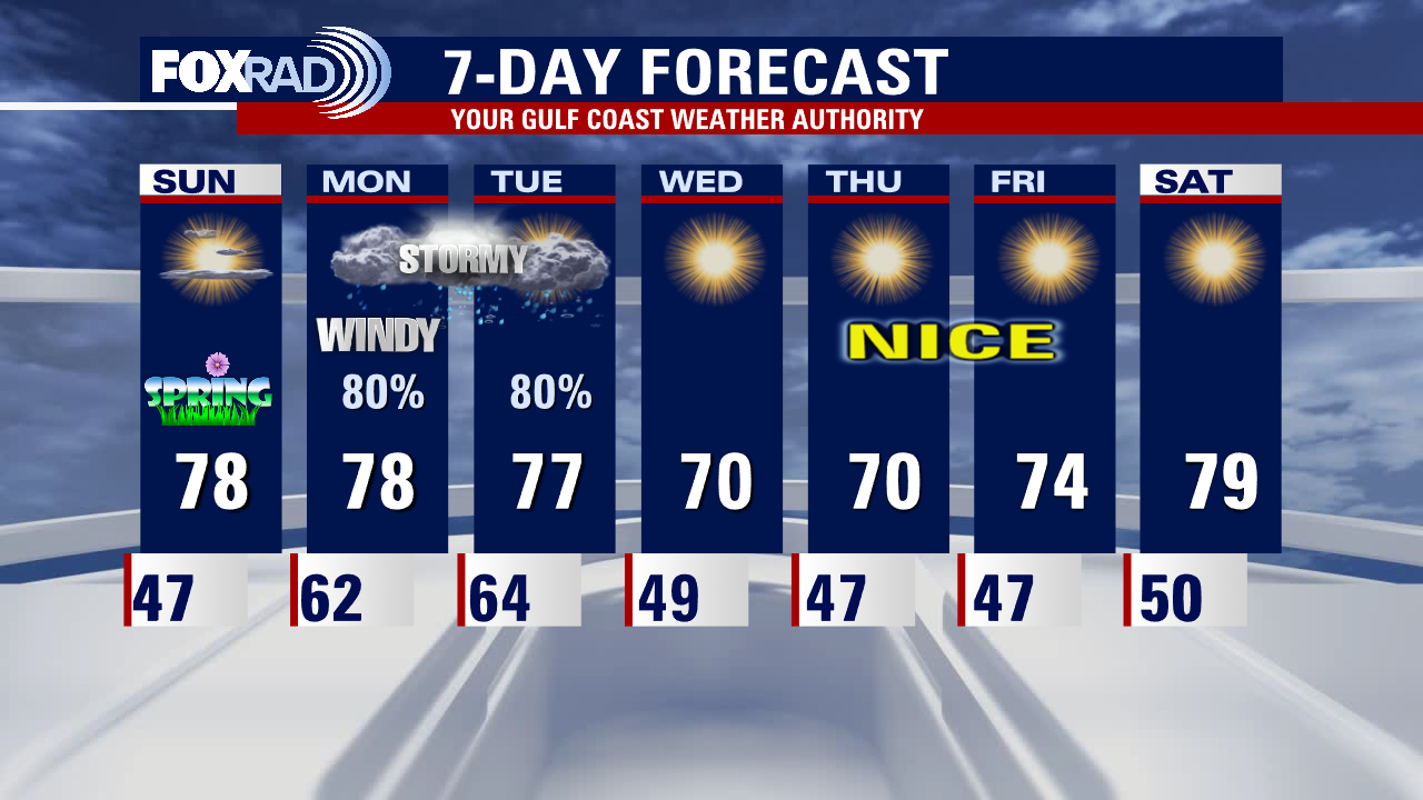
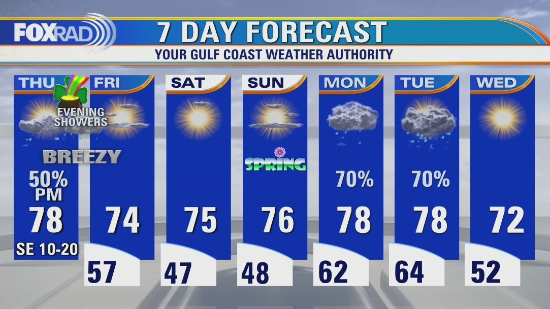
After an active, messy start to the workweek, the next seven days look incredibly quiet. You can look forward to plenty of sunny, dry days with low humidity although we'll be a bit breezy through Thursday. Temperatures will gradually climb, with lows going from the 40s to the 60s and highs going from the 60s to the 80s. Winds will relax over the weekend, but look to pick up again at the start of next week.
After an active, messy start to the workweek, the next seven days look incredibly quiet. You can look forward to plenty of sunny, dry days with low humidity although we'll be a bit breezy through Thursday. Temperatures will gradually climb, with lows going from the 40s to the 60s and highs going from the 60s to the 80s. Winds will relax over the weekend, but look to pick up again at the start of next week.

Tornado Report: Breakdown of March 21-22 tornadoes in Texas
Meteorologist Lina Maria Arango breaks down the stats on the tornadoes that moved through Texas on March 21 and 22.
Meteorologist Lina Maria Arango breaks down the stats on the tornadoes that moved through Texas on March 21 and 22.

Storms moving out, sunshine coming through
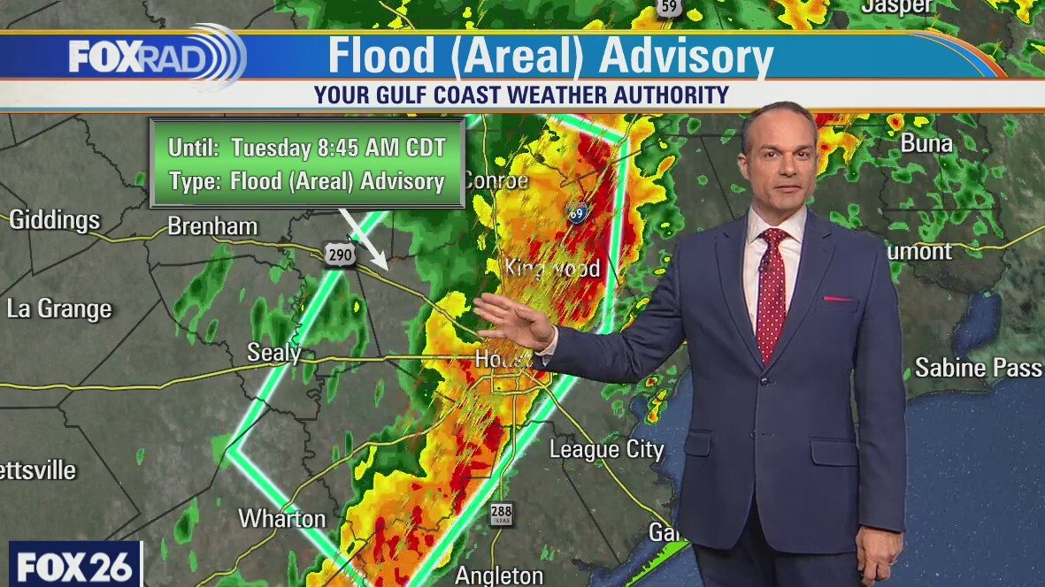
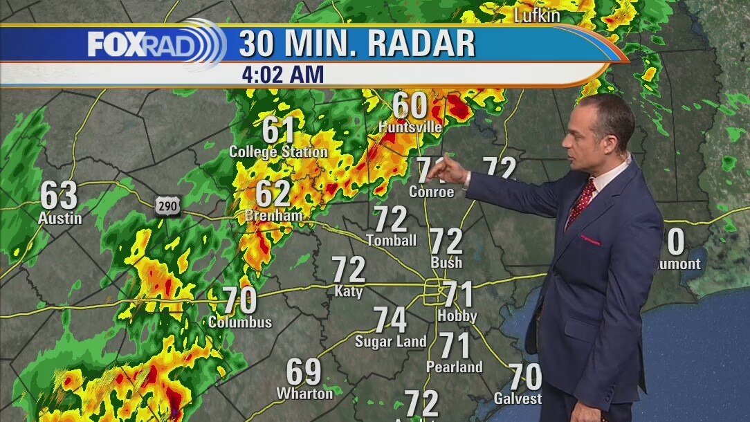
After morning thunderstorms brought up to 4" of rain along with high winds and incredible lightning, the forecast from here on out couldn't be nicer. Look for a series of clear and cool nights along with sunny, dry days. This time of the year, you can't beat lows in the 40s and highs in the 70s with low humidity.
After morning thunderstorms brought up to 4" of rain along with high winds and incredible lightning, the forecast from here on out couldn't be nicer. Look for a series of clear and cool nights along with sunny, dry days. This time of the year, you can't beat lows in the 40s and highs in the 70s with low humidity.
Storms move across the Houston area
FOX 26 Meteorologist has the latest on the severe weather in Southeast Texas and the forecast for the coming week.
FOX 26 Meteorologist has the latest on the severe weather in Southeast Texas and the forecast for the coming week.
Latest weather forecast from FOX 26 Meteorologist Mike Iscovitz
Strong storms are on the way to the Houston area this morning. Here's the latest weather forecast.
Strong storms are on the way to the Houston area this morning. Here's the latest weather forecast.
Monday evening weather forecast
Monday night looks stormy across southeast Texas. A FLOOD WATCH extends into Tuesday morning. The rest of the week look fantastic starting Tuesday afternoon.
Monday night looks stormy across southeast Texas. A FLOOD WATCH extends into Tuesday morning. The rest of the week look fantastic starting Tuesday afternoon.
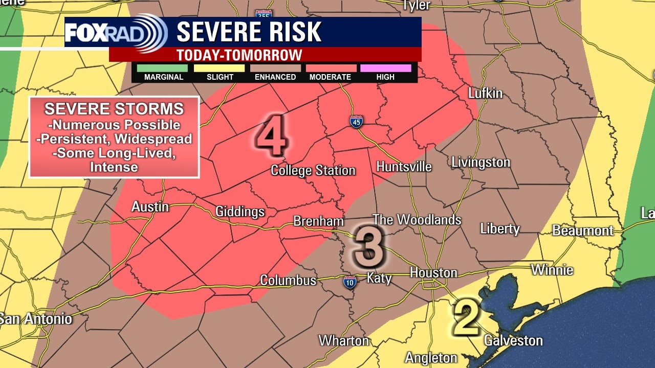
Strong to severe storms likely Monday afternoon
A wind advisory is in effect for the entire viewing area from 11 a.m. to 7 p.m. today. It will be cloudy, with lighter scattered showers in the morning increasing in intensity throughout the day. Strong to severe storms are likely beginning in the afternoon and lingering into the overnight hours, with all weather threats possible. Be sure to have multiple ways to receive alerts through tomorrow morning. By mid-morning Tuesday we'll start to see rapid improvements that will last throughout the west of the week. Quiet, pleasant weather lingers into the weekend.
A wind advisory is in effect for the entire viewing area from 11 a.m. to 7 p.m. today. It will be cloudy, with lighter scattered showers in the morning increasing in intensity throughout the day. Strong to severe storms are likely beginning in the afternoon and lingering into the overnight hours, with all weather threats possible. Be sure to have multiple ways to receive alerts through tomorrow morning. By mid-morning Tuesday we'll start to see rapid improvements that will last throughout the west of the week. Quiet, pleasant weather lingers into the weekend.
Strong to severe storms likely beginning Monday afternoon
A wind advisory is in effect for the entire viewing area from 11 a.m. to 7 p.m. today. It will be cloudy, with lighter scattered showers in the morning increasing in intensity throughout the day. Strong to severe storms are likely beginning in the afternoon and lingering into the overnight hours, with all weather threats possible. Be sure to have multiple ways to receive alerts through tomorrow morning. By mid-morning Tuesday we'll start to see rapid improvements that will last throughout the west of the week. Quiet, pleasant weather lingers into the weekend.
A wind advisory is in effect for the entire viewing area from 11 a.m. to 7 p.m. today. It will be cloudy, with lighter scattered showers in the morning increasing in intensity throughout the day. Strong to severe storms are likely beginning in the afternoon and lingering into the overnight hours, with all weather threats possible. Be sure to have multiple ways to receive alerts through tomorrow morning. By mid-morning Tuesday we'll start to see rapid improvements that will last throughout the west of the week. Quiet, pleasant weather lingers into the weekend.
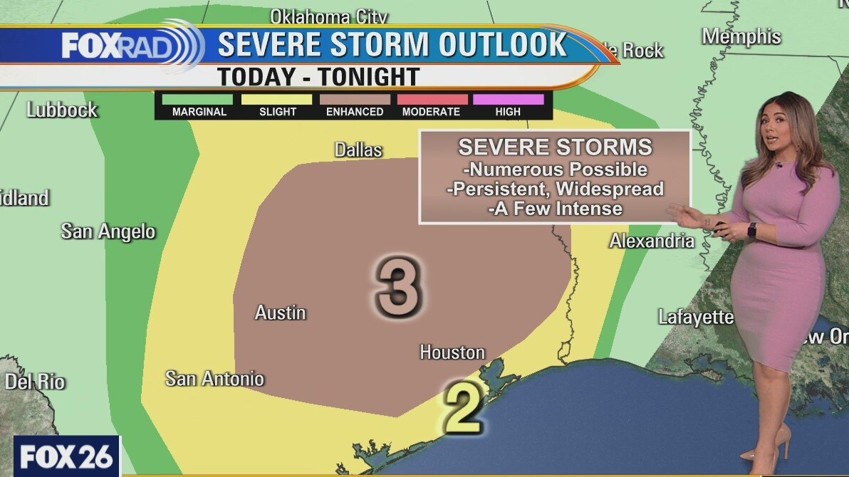
Sunday night leading into Monday morning weather forecast
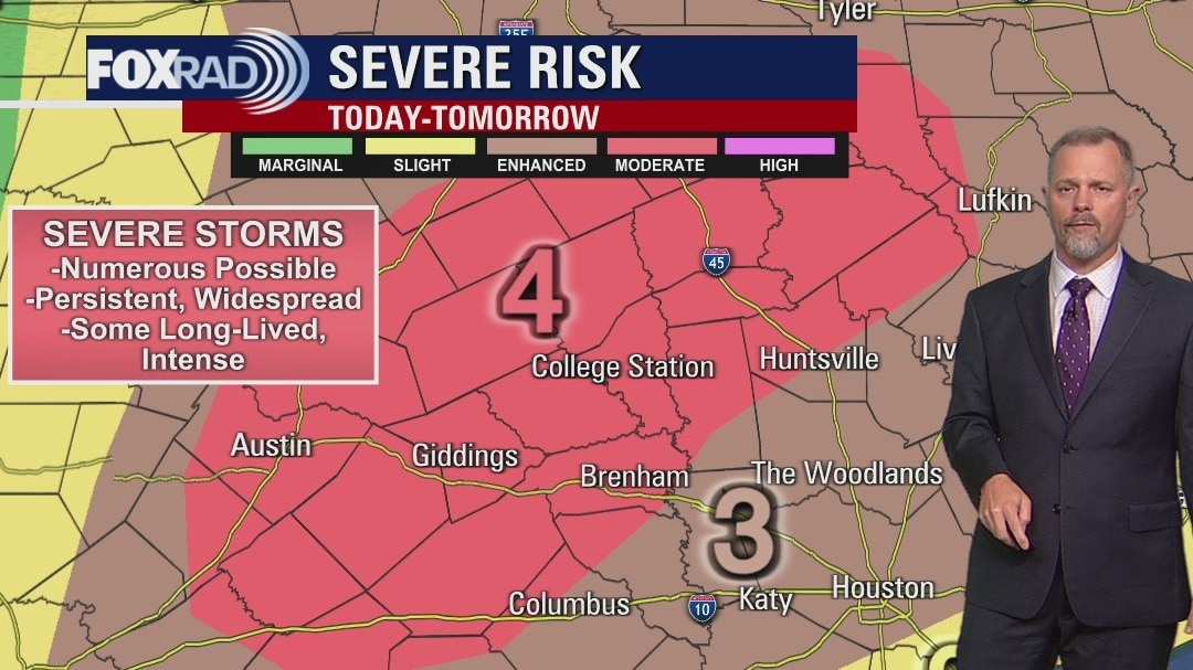
Confidence is growing in our risk for both heavy rain and severe storms beginning as early as Monday afternoon and getting worse Monday night into Tuesday morning. Flooding will be possible Tuesday morning and scattered severe storms could pop up late Monday. The positive news is that once a cold front moves through around midday Tuesday, our weather looks amazing - sunny and dry for the rest of the week.
Confidence is growing in our risk for both heavy rain and severe storms beginning as early as Monday afternoon and getting worse Monday night into Tuesday morning. Flooding will be possible Tuesday morning and scattered severe storms could pop up late Monday. The positive news is that once a cold front moves through around midday Tuesday, our weather looks amazing - sunny and dry for the rest of the week.
Sunday Morning Forecast with Meteorologist Lena Maria
The first day of Spring will be very quiet and calm, aside from a bit of a southeasterly breeze developing this afternoon and evening. Tomorrow will be a much different story, with lighter scattered showers throughout the morning and the threat for heavy rainfall and strong to severe storms increasing later in the day. Active weather tapers early morning Tuesday, and the rest of the week will be quiet, calm and dry.
The first day of Spring will be very quiet and calm, aside from a bit of a southeasterly breeze developing this afternoon and evening. Tomorrow will be a much different story, with lighter scattered showers throughout the morning and the threat for heavy rainfall and strong to severe storms increasing later in the day. Active weather tapers early morning Tuesday, and the rest of the week will be quiet, calm and dry.
Saturday night leading into Sunday weather forecast with Meteorologist Mike Iscovitz
Spring begins Sunday and our beautiful weather should continue for the most part. A southeast breeze will increase through the day Sunday and it's possible that some leftover smoke/haze, now in the Gulf of Mexico, could be noticeable. Our biggest concern is the risk for strong storms Monday and Tuesday. There is a chance for high winds and severe weather especially late Monday and early Tuesday.
Spring begins Sunday and our beautiful weather should continue for the most part. A southeast breeze will increase through the day Sunday and it's possible that some leftover smoke/haze, now in the Gulf of Mexico, could be noticeable. Our biggest concern is the risk for strong storms Monday and Tuesday. There is a chance for high winds and severe weather especially late Monday and early Tuesday.
Saturday Morning Forecast with Meteorologist Lena Maria
Wildfire smoke will not be as much of a concern today with lighter winds out of the northeast. Weather-wise, the weekend looks fantastic with no concerns. Monday and Tuesday will be a much different story, as a strengthening low pressure system and cold front approaches. The ingredients will be in place to support all severe weather threats, including heavy rain, strong winds, hail, and tornadoes.
Wildfire smoke will not be as much of a concern today with lighter winds out of the northeast. Weather-wise, the weekend looks fantastic with no concerns. Monday and Tuesday will be a much different story, as a strengthening low pressure system and cold front approaches. The ingredients will be in place to support all severe weather threats, including heavy rain, strong winds, hail, and tornadoes.
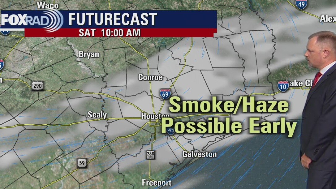
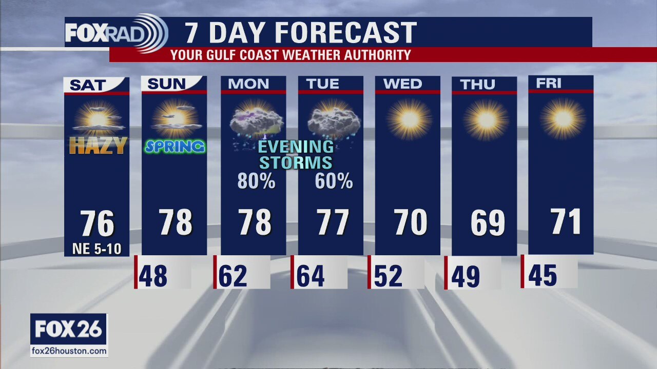
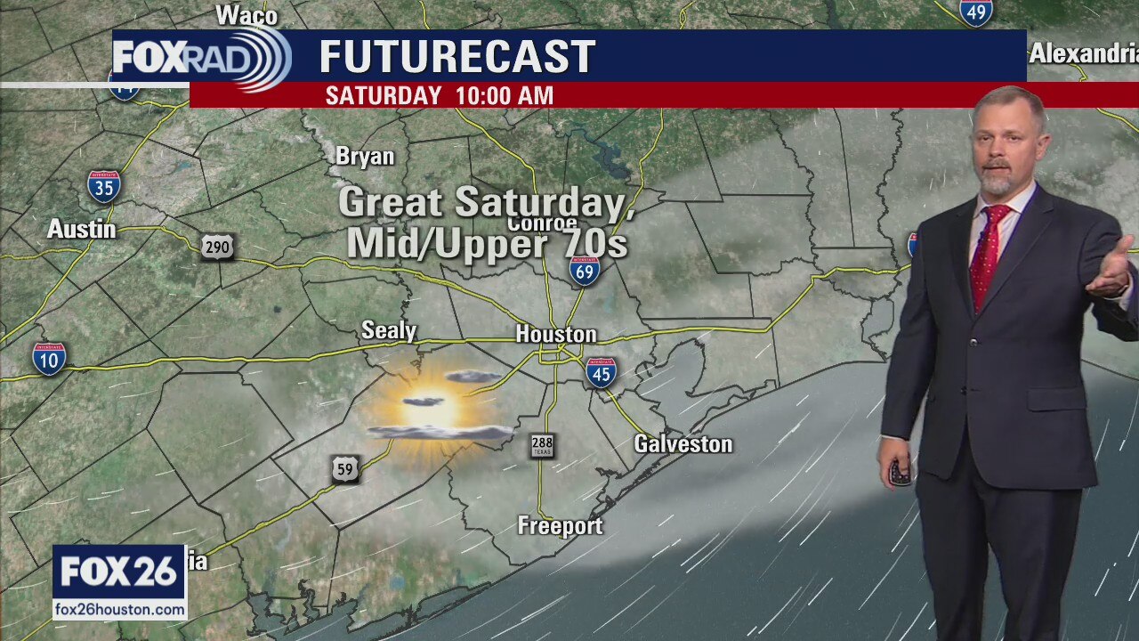
Saturday morning weather forecast
Saturday could see some more haze or smoke early in the day along with some cool temperatures. Look for the afternoon to be near perfect for Houston. A few more clouds return on Sunday afternoon but still a great day to be outside. The next round of spring storms should arrive to southeast Texas late in the day on Monday. Some of those could be strong to severe, so stay connected to FOX 26!
Saturday could see some more haze or smoke early in the day along with some cool temperatures. Look for the afternoon to be near perfect for Houston. A few more clouds return on Sunday afternoon but still a great day to be outside. The next round of spring storms should arrive to southeast Texas late in the day on Monday. Some of those could be strong to severe, so stay connected to FOX 26!
Friday Evening Weather Forecast
FOX 26 Meteorologist John Dawson has the latest on this weekend's weather.
FOX 26 Meteorologist John Dawson has the latest on this weekend's weather.

Smoky skies in Houston as wildfires burn in Texas
A surprisingly thick plume of smoke has arrived in the Houston area from a large complex of wildfires southwest of Fort Worth. Nearly 40,000 acres of brush and grassland is burning and is uncontained. It looks like the smoke plume became larger overnight and was blown directly at us by dry, breezy northwest winds.
A surprisingly thick plume of smoke has arrived in the Houston area from a large complex of wildfires southwest of Fort Worth. Nearly 40,000 acres of brush and grassland is burning and is uncontained. It looks like the smoke plume became larger overnight and was blown directly at us by dry, breezy northwest winds.
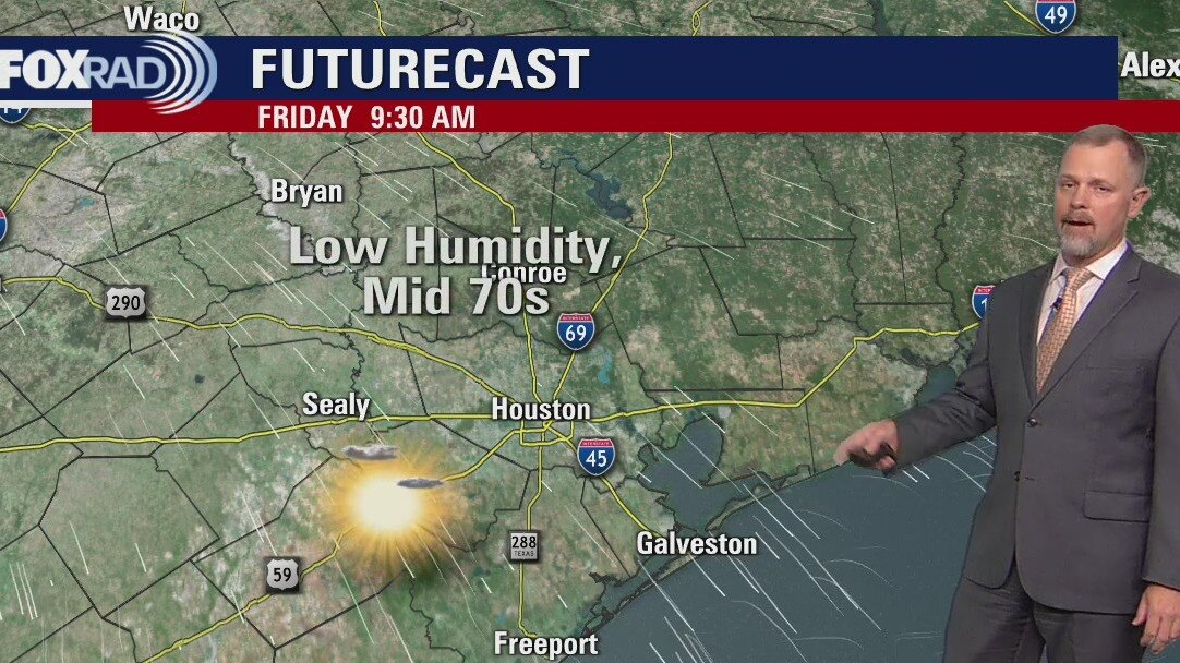
Friday morning weather forecast
Thursday night will see drizzle and light rain across Houston. A weak front moves into southeast Texas and clears out the skies early on Friday morning. Look for clear skies and breezy conditions leading into a fantastic weekend. Spring storms will appear again at the start of next week. Stay connected as you enjoy the weekend outdoors.
Thursday night will see drizzle and light rain across Houston. A weak front moves into southeast Texas and clears out the skies early on Friday morning. Look for clear skies and breezy conditions leading into a fantastic weekend. Spring storms will appear again at the start of next week. Stay connected as you enjoy the weekend outdoors.
Thursday evening weather forecast
Thursday night will see drizzle and light rain across Houston. A weak front moves into southeast Texas and clears out the skies early on Friday morning. Look for clear skies and breezy conditions leading into a fantastic weekend. Spring storms will appear again at the start of next week. Stay connected as you enjoy the weekend outdoors.
Thursday night will see drizzle and light rain across Houston. A weak front moves into southeast Texas and clears out the skies early on Friday morning. Look for clear skies and breezy conditions leading into a fantastic weekend. Spring storms will appear again at the start of next week. Stay connected as you enjoy the weekend outdoors.
Thursday afternoon weather forecast
Watch for scattered showers late today along with increasing clouds and breezy southeast winds. A weak front will move through overnight followed by sunny, dry weather Friday through the weekend. We will watch for the potential for rainy weather by Monday and Tuesday.
Watch for scattered showers late today along with increasing clouds and breezy southeast winds. A weak front will move through overnight followed by sunny, dry weather Friday through the weekend. We will watch for the potential for rainy weather by Monday and Tuesday.
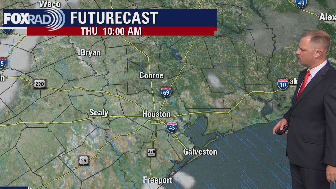
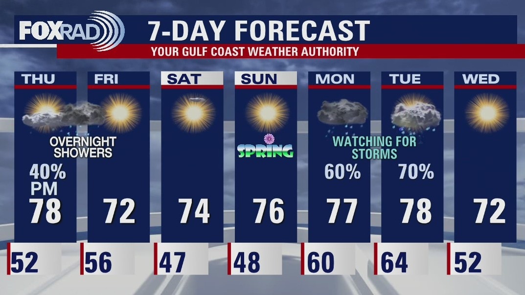
Thursday morning weather forecast
Rain returns to the forecast for Houston late Thursday as a front moves through southeast Texas. Most of the rain will fall after sunset and there should be more showers than storms. The weekend will be fantastic! We are watching another storm system for the start of next week that could bring stronger storms into the FOX 26 area.
Rain returns to the forecast for Houston late Thursday as a front moves through southeast Texas. Most of the rain will fall after sunset and there should be more showers than storms. The weekend will be fantastic! We are watching another storm system for the start of next week that could bring stronger storms into the FOX 26 area.
Wednesday evening weather forecast
Rain returns to the forecast for Houston late Thursday as a front moves through southeast Texas. Most of the rain will fall after sunset and there should be more showers than storms. The weekend will be fantastic! We are watching another storm system for the start of next week that could bring stronger storms into the FOX26 area.
Rain returns to the forecast for Houston late Thursday as a front moves through southeast Texas. Most of the rain will fall after sunset and there should be more showers than storms. The weekend will be fantastic! We are watching another storm system for the start of next week that could bring stronger storms into the FOX26 area.