

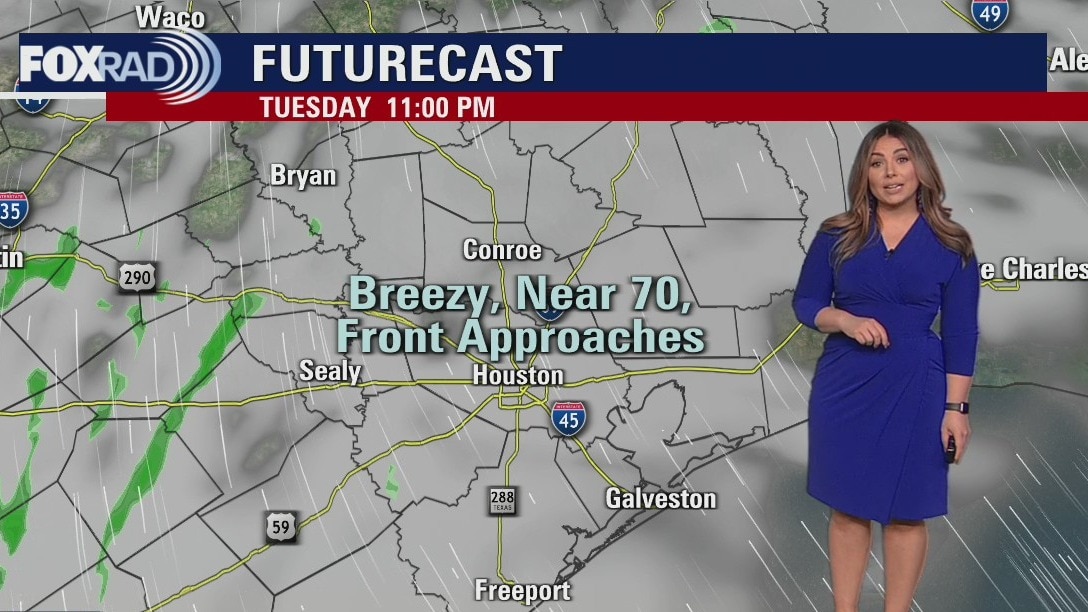
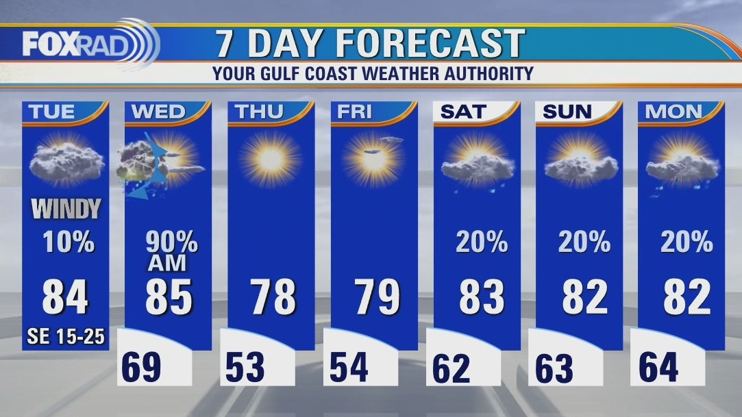
Tuesday evening weather forecast
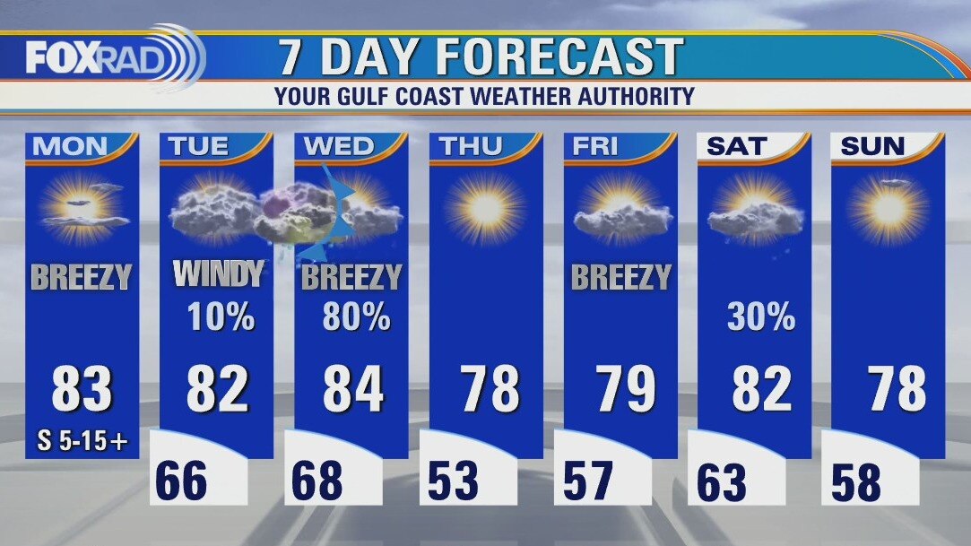
A cold front will bring a brief dose of showers and storms to southeast Texas on Wednesday morning. Severe weather is not expected, but rain could be briefly heavy along with some gusty winds. There is a Wind Advisory in effect for most of the area through 7 am Wednesday morning, and then a Fire Weather Watch from 1 pm - 7 pm for southwestern portions of the viewing area. Sun returns quickly by lunch Wednesday. Thursday and Friday will be a touch cooler, and much less humid. Another front brings shower chances overnight Friday into Saturday, with a third front at the start of next week. The good news is, the rain will help with allergies and we definitely need it due to the developing drought conditions.
A cold front will bring a brief dose of showers and storms to southeast Texas on Wednesday morning. Severe weather is not expected, but rain could be briefly heavy along with some gusty winds. There is a Wind Advisory in effect for most of the area through 7 am Wednesday morning, and then a Fire Weather Watch from 1 pm - 7 pm for southwestern portions of the viewing area. Sun returns quickly by lunch Wednesday. Thursday and Friday will be a touch cooler, and much less humid. Another front brings shower chances overnight Friday into Saturday, with a third front at the start of next week. The good news is, the rain will help with allergies and we definitely need it due to the developing drought conditions.
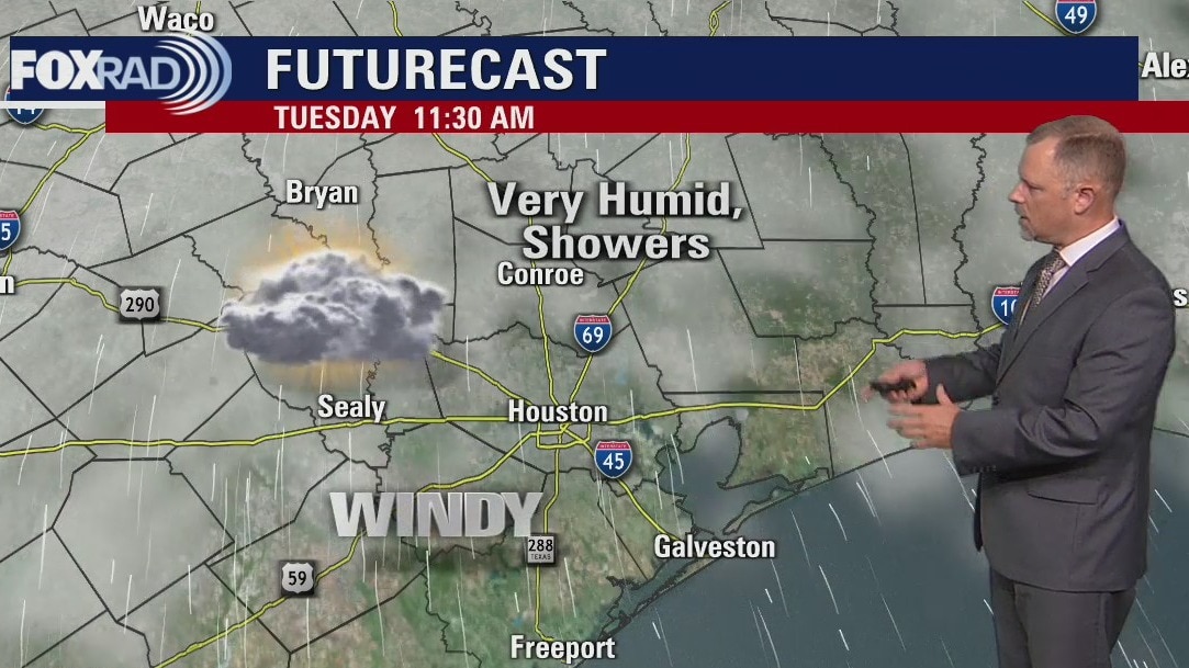
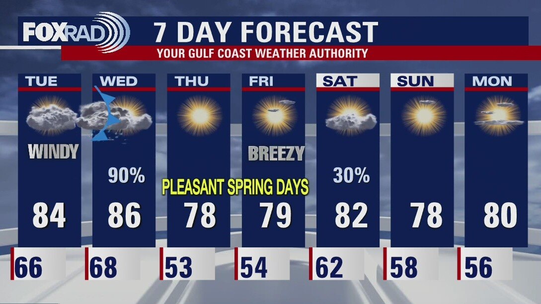
Tuesday afternoon weather forecast
There are so many wind and fire related advisories statewide today. Locally, we are under a wind advisory from 10 a.m. this morning through 7 a.m. tomorrow. After a line of storms for us tomorrow mid-morning, a fire weather watch is in effect from 1 p.m. - 7 p.m. tomorrow due to gusty winds and very low humidity. Beautiful weather is on the way for late this week.
There are so many wind and fire related advisories statewide today. Locally, we are under a wind advisory from 10 a.m. this morning through 7 a.m. tomorrow. After a line of storms for us tomorrow mid-morning, a fire weather watch is in effect from 1 p.m. - 7 p.m. tomorrow due to gusty winds and very low humidity. Beautiful weather is on the way for late this week.
Tuesday morning weather forecast
Houston should see some rain on Wednesday morning as a Spring storm system moves across Texas. Severe weather is expected to avoid southeast Texas but we could certainly have some thunderstorms as the front moves across the area. The rest of the week looks quiet before some rain chances return for the start of the weekend.
Houston should see some rain on Wednesday morning as a Spring storm system moves across Texas. Severe weather is expected to avoid southeast Texas but we could certainly have some thunderstorms as the front moves across the area. The rest of the week looks quiet before some rain chances return for the start of the weekend.
Monday evening weather forecast
Houston should see some rain on Wednesday morning as a Spring storm system moves across Texas. Severe weather is expected to avoid southeast Texas but we could certainly have some thunderstorms as the front moves across the area. The rest of the week looks quiet before some rain chances return for the start of the weekend.
Houston should see some rain on Wednesday morning as a Spring storm system moves across Texas. Severe weather is expected to avoid southeast Texas but we could certainly have some thunderstorms as the front moves across the area. The rest of the week looks quiet before some rain chances return for the start of the weekend.
Monday afternoon weather forecast
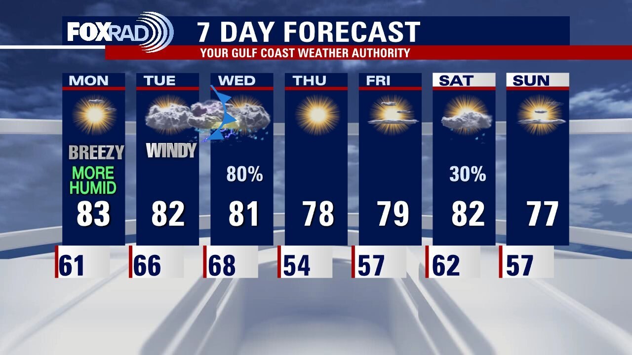
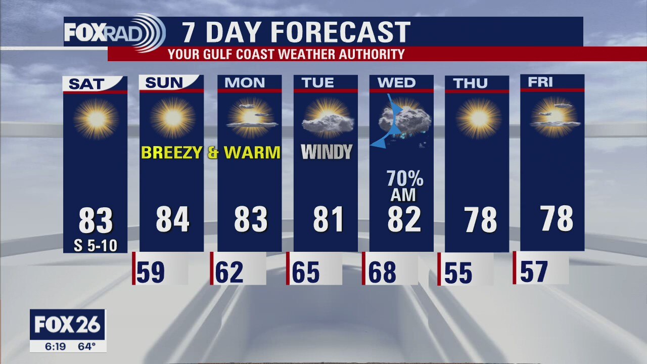
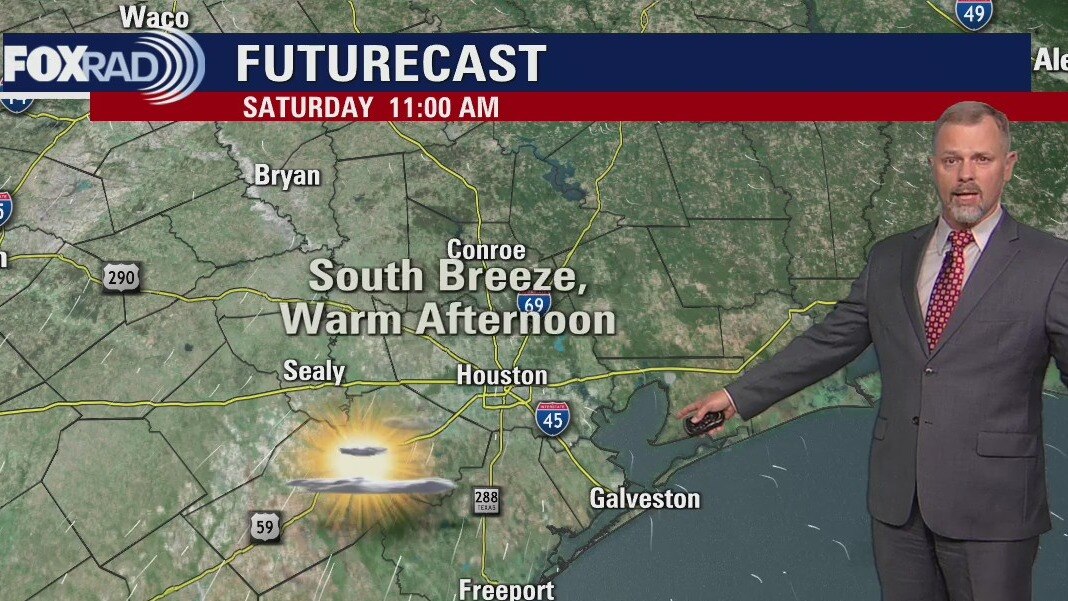
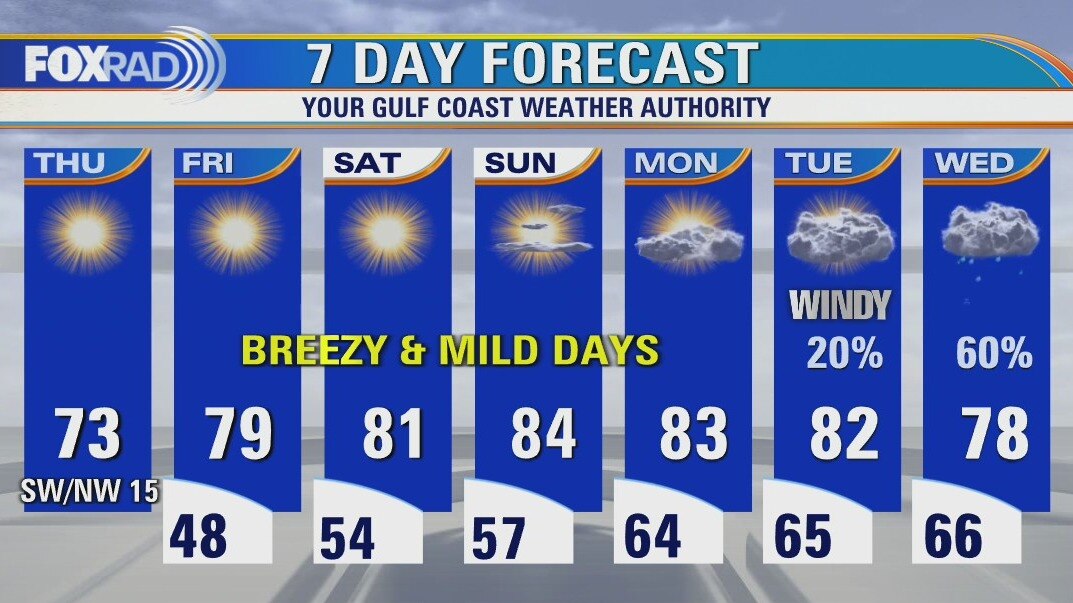
Another warm and breezy afternoon on tap, with mostly sunny skies. Look out for patchy morning fog the next few mornings before our next front. Tuesday clouds and winds will increase ahead of the system, but aside from light streamer showers we stay mostly dry until Wednesday morning. A quick moving line of non-severe showers and storms look to arrive in southeast Texas by mid-morning Wednesday, clearing by around lunch time. We may see some more showers overnight Friday into Saturday, but otherwise the rest of the week looks pleasant and dry!
Another warm and breezy afternoon on tap, with mostly sunny skies. Look out for patchy morning fog the next few mornings before our next front. Tuesday clouds and winds will increase ahead of the system, but aside from light streamer showers we stay mostly dry until Wednesday morning. A quick moving line of non-severe showers and storms look to arrive in southeast Texas by mid-morning Wednesday, clearing by around lunch time. We may see some more showers overnight Friday into Saturday, but otherwise the rest of the week looks pleasant and dry!
Sunday evening leading into Monday morning weather forecast with Meteorologist John Dawson
Humidity returns to southeast Texas on Monday. Look for windy conditions Tuesday as the next storm system moves across the state. Houston should avoid severe storms on Wednesday morning but there will be some rain and isolated heavy downpours.
Humidity returns to southeast Texas on Monday. Look for windy conditions Tuesday as the next storm system moves across the state. Houston should avoid severe storms on Wednesday morning but there will be some rain and isolated heavy downpours.
Sunday Morning Forecast with Meteorologist Lena Maria
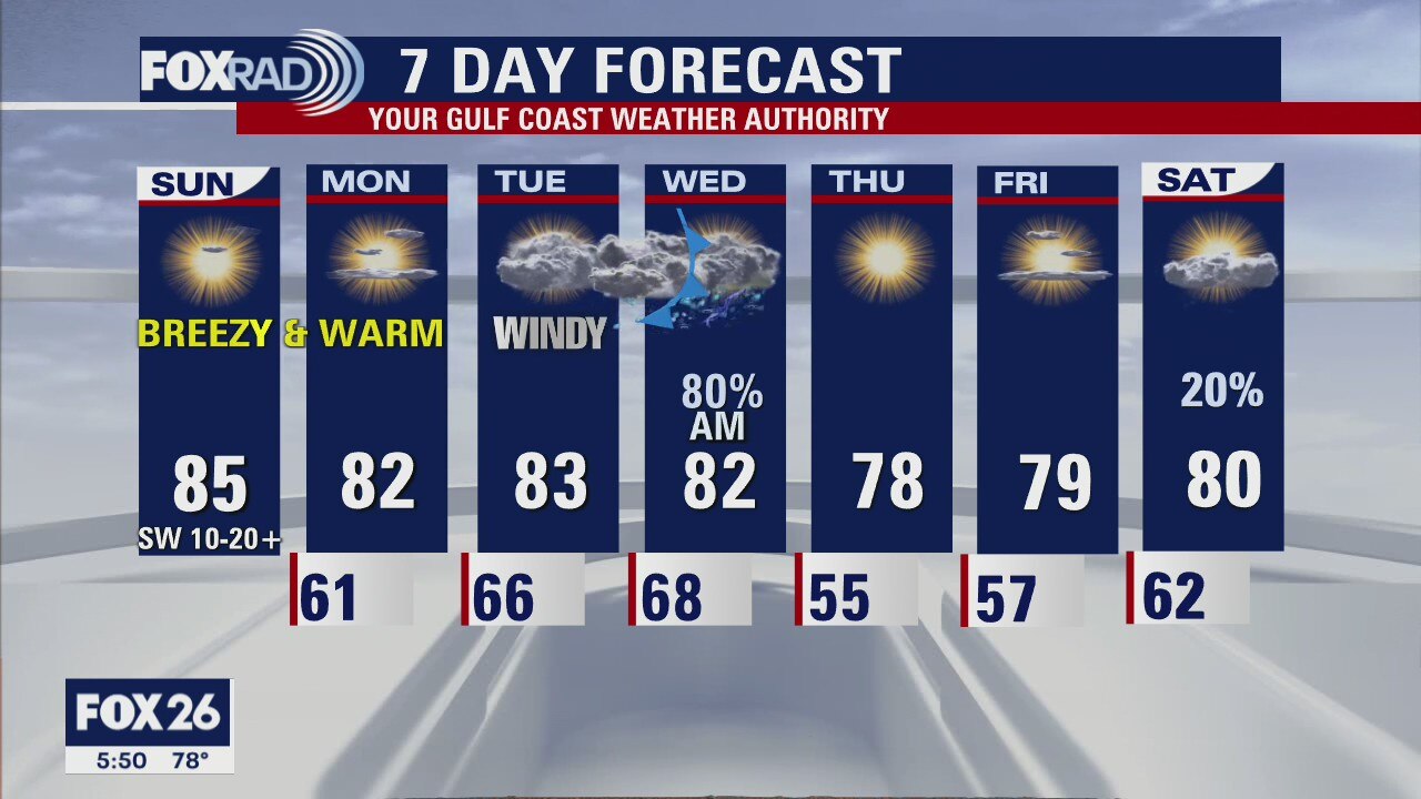
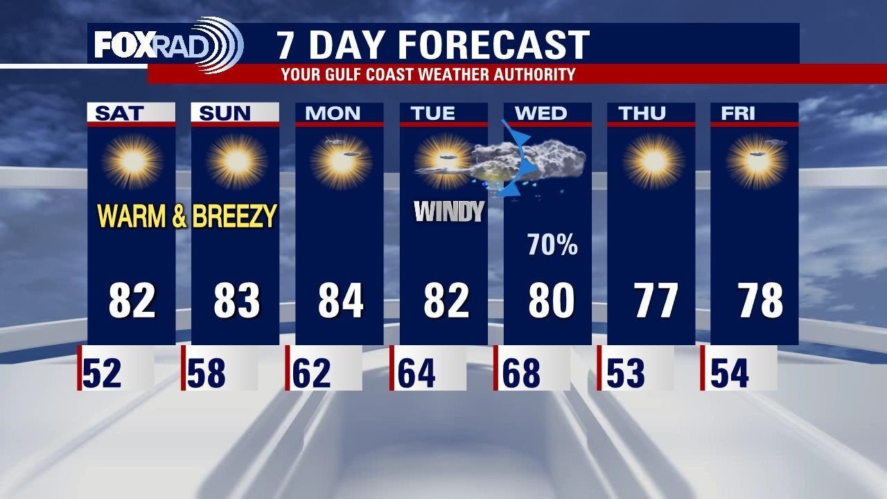
The weekend ends just like it started, sunny and warm with a bit more oomph behind that southerly wind which will increase humidity at the start of the work week. Look out for patchy morning fog, and warm afternoons until our next frontal system which looks to bring rain and non-severe thunderstorms to the area Wednesday morning. We will keep an eye on any possibilities for stronger or severe storms, that currently look to stay to our north and east. Behind the front, slightly cooler temps and lower humidity but back comes the warmth and rain chances by Saturday.
The weekend ends just like it started, sunny and warm with a bit more oomph behind that southerly wind which will increase humidity at the start of the work week. Look out for patchy morning fog, and warm afternoons until our next frontal system which looks to bring rain and non-severe thunderstorms to the area Wednesday morning. We will keep an eye on any possibilities for stronger or severe storms, that currently look to stay to our north and east. Behind the front, slightly cooler temps and lower humidity but back comes the warmth and rain chances by Saturday.
Saturday evening into Sunday morning weather forecast with Meteorologist John Dawson
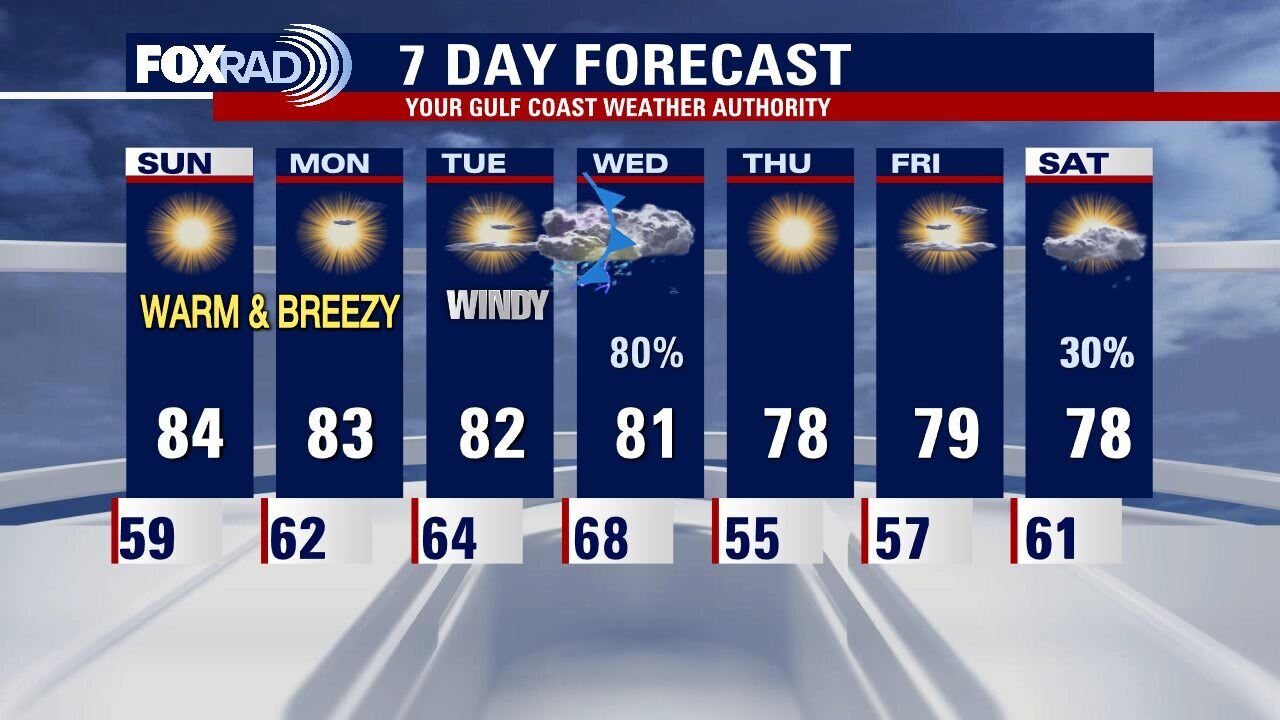
More great outdoor weather for the rest of the weekend in Southeast Texas. Make plans to get outside over the next several days. Houston should see another round of spring storms Tuesday night into Wednesday morning. For now severe storms are not expected but we will need to continue to monitor this system as we get closer to their arrival. There will be strong storms in some parts of Texas.
More great outdoor weather for the rest of the weekend in Southeast Texas. Make plans to get outside over the next several days. Houston should see another round of spring storms Tuesday night into Wednesday morning. For now severe storms are not expected but we will need to continue to monitor this system as we get closer to their arrival. There will be strong storms in some parts of Texas.
Saturday Morning Forecast with Meteorologist Lena Maria
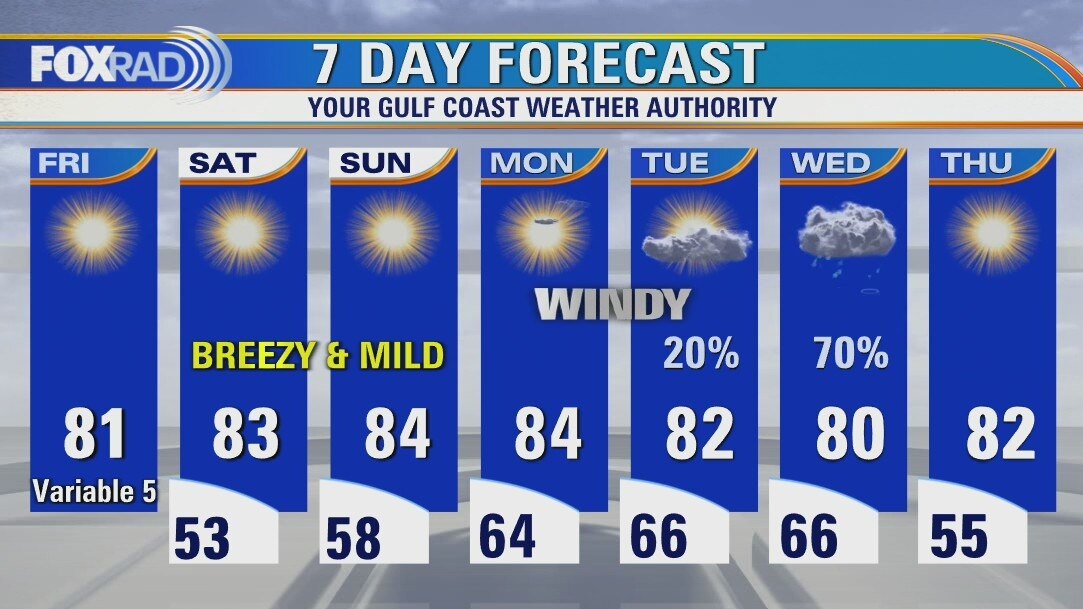
With light winds and low humidity, Saturday is shaping up to be a stunner of a day. Several dry and warm, but breezy days will follow with increasing humidity and cloud cover. Tuesday will be windy as the pressure gradient tightens ahead of our next system, which looks to bring showers and storms Wednesday morning. At this time, any potential for severe weather looks to stay to our north and east but with several days to go we will monitor for any developments and changes. After that, back to beautiful dry spring time weather.
With light winds and low humidity, Saturday is shaping up to be a stunner of a day. Several dry and warm, but breezy days will follow with increasing humidity and cloud cover. Tuesday will be windy as the pressure gradient tightens ahead of our next system, which looks to bring showers and storms Wednesday morning. At this time, any potential for severe weather looks to stay to our north and east but with several days to go we will monitor for any developments and changes. After that, back to beautiful dry spring time weather.
Saturday morning weather forecast
Great looking weekend in southeast Texas with lots of clear skies and relatively dry air across Houston. Temperatures will be warm until the next storm system moves across our region on Wednesday. We are continuing to monitor that system for the possibility of strong to severe storms.
Great looking weekend in southeast Texas with lots of clear skies and relatively dry air across Houston. Temperatures will be warm until the next storm system moves across our region on Wednesday. We are continuing to monitor that system for the possibility of strong to severe storms.
Friday evening weather with Meteorologist John Dawson
Great looking weekend in southeast Texas with lots of clear skies and relatively dry air across Houston. Temperatures will be warm until the next storm system moves across our region on Wednesday. We are continuing to monitor that system for the possibility of strong to severe storms.
Great looking weekend in southeast Texas with lots of clear skies and relatively dry air across Houston. Temperatures will be warm until the next storm system moves across our region on Wednesday. We are continuing to monitor that system for the possibility of strong to severe storms.
Friday afternoon weather forecast
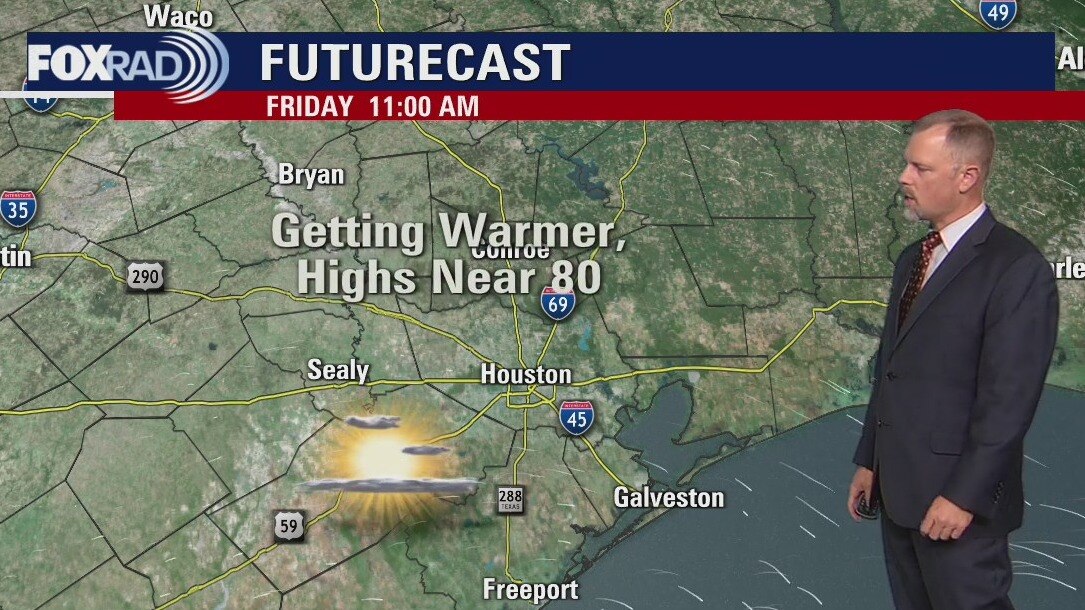
A warming trend will kick in today and take us through early next week. After a cold morning, look for highs today near 80 with light winds and low humidity. Elevated levels of ozone are possible this afternoon which can be irritating to those with sensitive lungs. This weekend will see the return of a south breeze and highs in the low to mid 80s. Our next chance for storms is Wednesday and we will monitor for the risk of severe weather.
A warming trend will kick in today and take us through early next week. After a cold morning, look for highs today near 80 with light winds and low humidity. Elevated levels of ozone are possible this afternoon which can be irritating to those with sensitive lungs. This weekend will see the return of a south breeze and highs in the low to mid 80s. Our next chance for storms is Wednesday and we will monitor for the risk of severe weather.
Friday morning weather forecast
Sunny and dry around southeast Texas for the start of the weekend. Houston will warm up to the mid-80s on Sunday afternoon. The next storm system will arrive Tuesday night. We'll continue to monitor for another round of spring storms as we get closer to that time.
Sunny and dry around southeast Texas for the start of the weekend. Houston will warm up to the mid-80s on Sunday afternoon. The next storm system will arrive Tuesday night. We'll continue to monitor for another round of spring storms as we get closer to that time.
Thursday evening weather forecast with Meteorologist John Dawson
Sunny and dry around southeast Texas for the start of the weekend. Houston will warm up to the mid-80s on Sunday afternoon. The next storm system will arrive Tuesday night. We'll continue to monitor for another round of spring storms as we get closer to that time.
Sunny and dry around southeast Texas for the start of the weekend. Houston will warm up to the mid-80s on Sunday afternoon. The next storm system will arrive Tuesday night. We'll continue to monitor for another round of spring storms as we get closer to that time.
Thursday afternoon weather forecast
Our top weather headlines today include very dry air, pleasant afternoon temperatures and extreme levels of tree pollen. Oak pollen is the primary issue, but cedar, elm, ash and pine will be mixed in as well. for Friday and the weekend, expect warmer afternoons with highs back in the low 80s along with breezy south winds. Watch for storms on Wednesday,
Our top weather headlines today include very dry air, pleasant afternoon temperatures and extreme levels of tree pollen. Oak pollen is the primary issue, but cedar, elm, ash and pine will be mixed in as well. for Friday and the weekend, expect warmer afternoons with highs back in the low 80s along with breezy south winds. Watch for storms on Wednesday,

Thursday morning weather forecast
Northwesterly breezes that have been ushering in very high levels of tree pollen continue into the day on Thursday. But, sunny, dry, pleasant weather with low humidity will also continue. As such, fire weather concerns may emerge locally with no rain in sight until next week. Winds lighten over the weekend, and with the return of southerly flow warmth and humidity will be on the increase. Our next opportunity for rain looks to arrive middle of next week.
Northwesterly breezes that have been ushering in very high levels of tree pollen continue into the day on Thursday. But, sunny, dry, pleasant weather with low humidity will also continue. As such, fire weather concerns may emerge locally with no rain in sight until next week. Winds lighten over the weekend, and with the return of southerly flow warmth and humidity will be on the increase. Our next opportunity for rain looks to arrive middle of next week.
Wednesday evening weather forecast with Meteorologist Lena Maria Arango
Northwesterly breezes that have been ushering in very high levels of tree pollen continue into the day on Thursday. But, sunny, dry, pleasant weather with low humidity will also continue. As such, fire weather concerns may emerge locally with no rain in sight until next week. Winds lighten over the weekend, and with the return of southerly flow warmth and humidity will be on the increase. Our next opportunity for rain looks to arrive middle of next week.
Northwesterly breezes that have been ushering in very high levels of tree pollen continue into the day on Thursday. But, sunny, dry, pleasant weather with low humidity will also continue. As such, fire weather concerns may emerge locally with no rain in sight until next week. Winds lighten over the weekend, and with the return of southerly flow warmth and humidity will be on the increase. Our next opportunity for rain looks to arrive middle of next week.
Wednesday afternoon weather forecast with Meteorologist Mike Iscovitz
What a difference a day makes. Following heavy rain and severe storms on Tuesday morning, we are now in a long period of sunny, dry weather. Look for cool air each night through the end of the week with many areas in the 40s. Afternoon highs will slowly climb from near 70 today to the mid-80s by this weekend.
What a difference a day makes. Following heavy rain and severe storms on Tuesday morning, we are now in a long period of sunny, dry weather. Look for cool air each night through the end of the week with many areas in the 40s. Afternoon highs will slowly climb from near 70 today to the mid-80s by this weekend.
Wednesday afternoon weather forecast
What a difference a day makes. Following heavy rain and severe storms on Tuesday morning, we are now in a long period of sunny, dry weather. Look for cool air each night through the end of the week with many areas in the 40s. Afternoon highs will slowly climb from near 70 today to the mid 80s by this weekend.
What a difference a day makes. Following heavy rain and severe storms on Tuesday morning, we are now in a long period of sunny, dry weather. Look for cool air each night through the end of the week with many areas in the 40s. Afternoon highs will slowly climb from near 70 today to the mid 80s by this weekend.
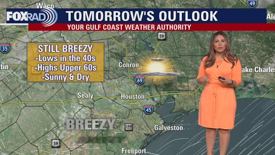
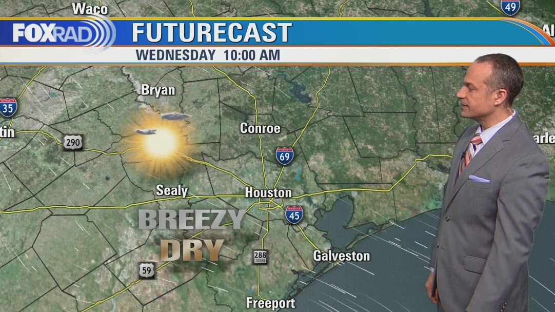
Wednesday morning weather forecast
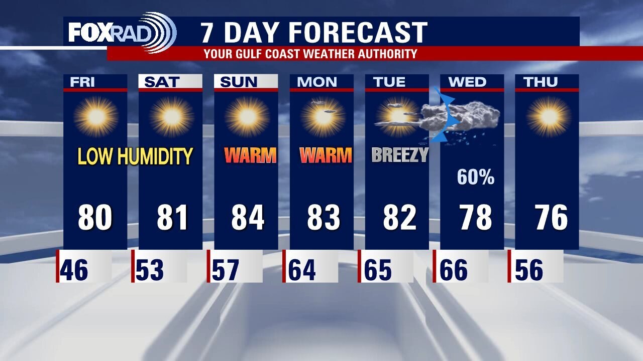
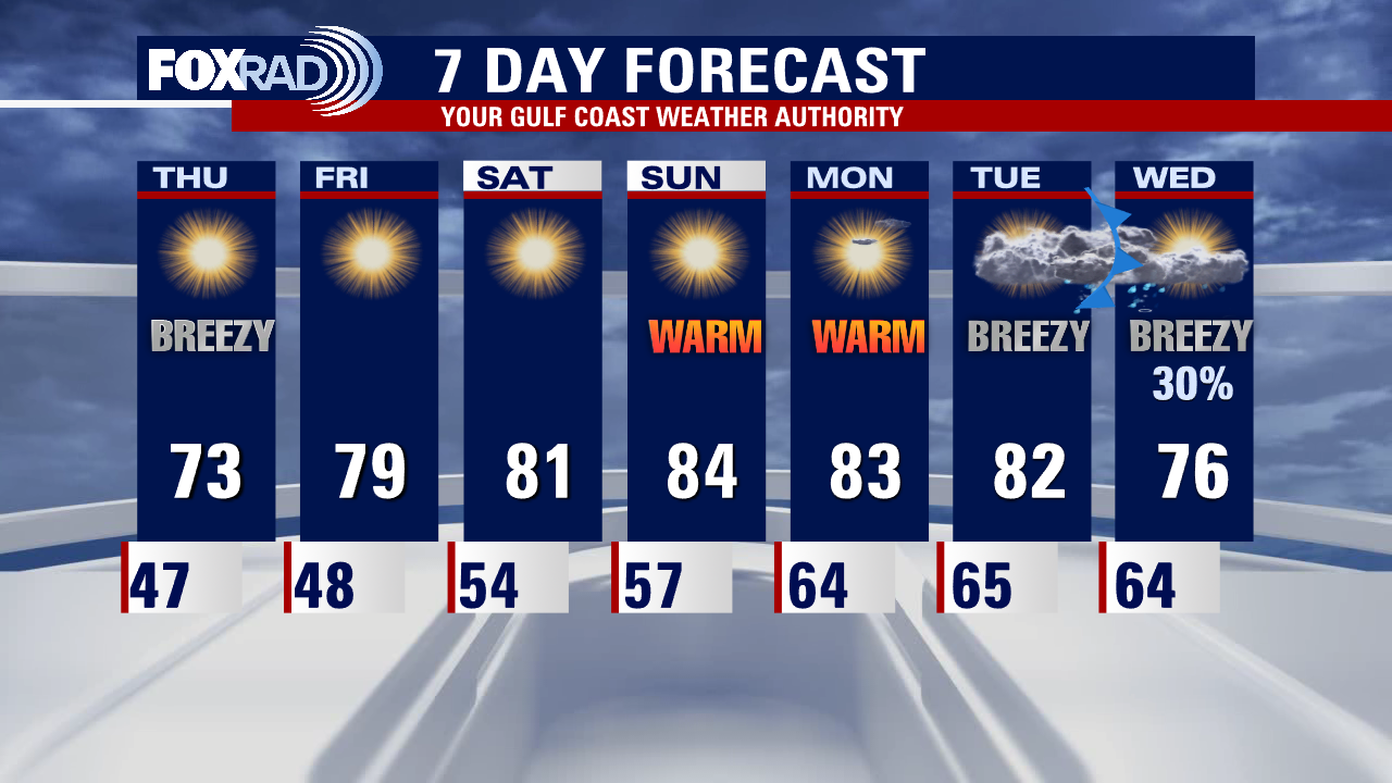
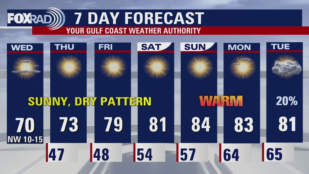
After an active, messy start to the workweek, the next seven days look incredibly quiet. You can look forward to plenty of sunny, dry days with low humidity although we'll be a bit breezy through Thursday. Temperatures will gradually climb, with lows going from the 40s to the 60s and highs going from the 60s to the 80s. Winds will relax over the weekend, but look to pick up again at the start of next week.
After an active, messy start to the workweek, the next seven days look incredibly quiet. You can look forward to plenty of sunny, dry days with low humidity although we'll be a bit breezy through Thursday. Temperatures will gradually climb, with lows going from the 40s to the 60s and highs going from the 60s to the 80s. Winds will relax over the weekend, but look to pick up again at the start of next week.