

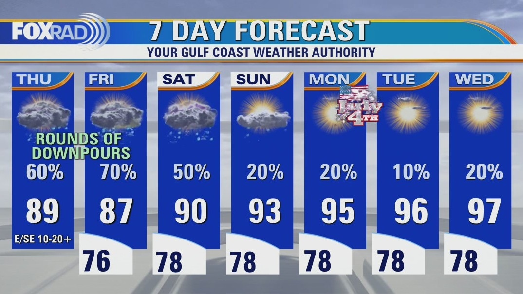
Downpours as we head into holiday weekend
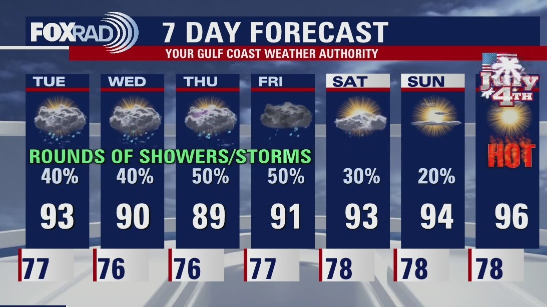
A Tropical Disturbance will bring us rounds of downpours to end the work week, with some moisture lingering into the day on Saturday. As we head through the holiday weekend, we will transition to a drier, more typical summer-like pattern. July 4th looks warm and humid, and past that we'll only hang on to isolated chances for daily afternoon showers/storms.
A Tropical Disturbance will bring us rounds of downpours to end the work week, with some moisture lingering into the day on Saturday. As we head through the holiday weekend, we will transition to a drier, more typical summer-like pattern. July 4th looks warm and humid, and past that we'll only hang on to isolated chances for daily afternoon showers/storms.
Warm & muggy start Thursday; rain chances increase throughout day
A Tropical Disturbance will bring us rounds of downpours to end the work week, with some moisture lingering into the day on Saturday. As we head through the holiday weekend, we will transition to a drier, more typical summer-like pattern. July 4th looks warm and humid, and past that we'll only hang on to isolated chances for daily afternoon showers/storms.
A Tropical Disturbance will bring us rounds of downpours to end the work week, with some moisture lingering into the day on Saturday. As we head through the holiday weekend, we will transition to a drier, more typical summer-like pattern. July 4th looks warm and humid, and past that we'll only hang on to isolated chances for daily afternoon showers/storms.
Thursday morning weather forecast
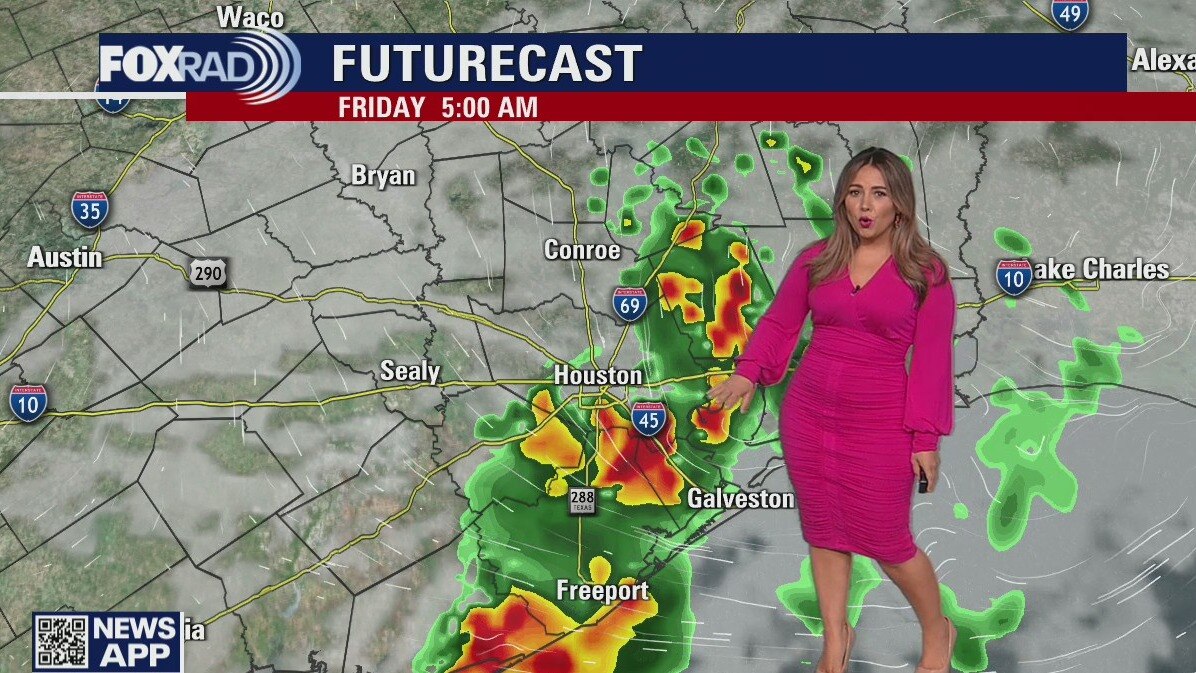
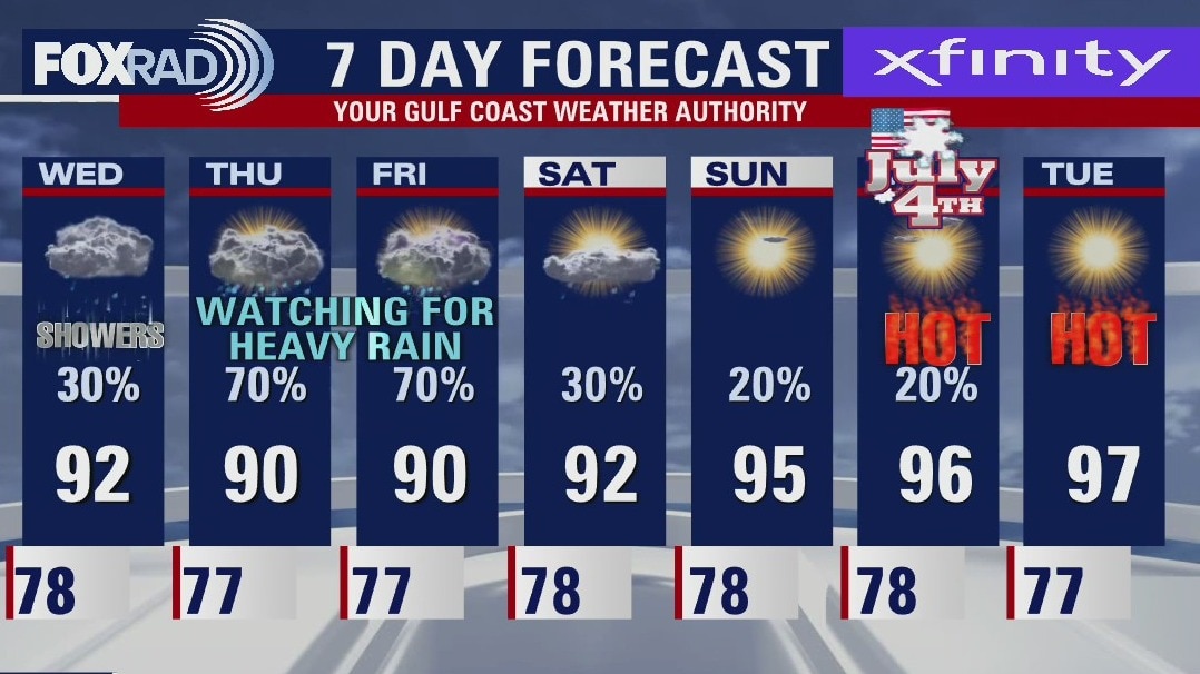
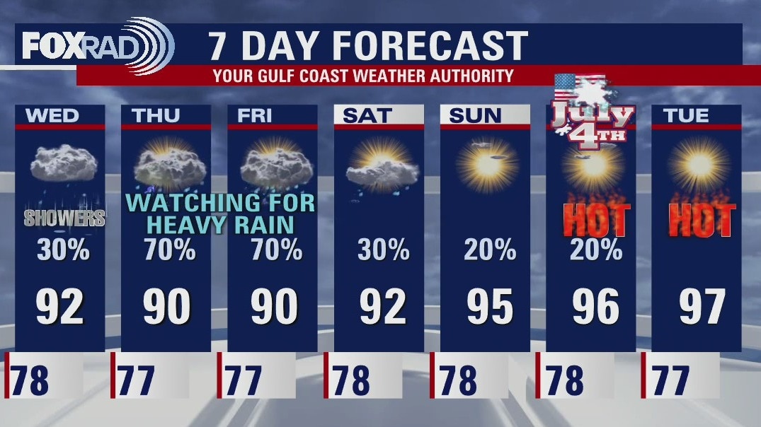
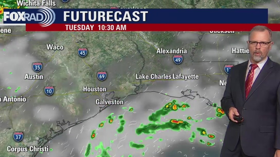
The end of the week continues to look wet for Houston. The Gulf Low will move inland and bring much needed rain to Southeast Texas. Rainfall totals still look manageable with the higher totals near the coast. Saturday will start the transition to a drier forecast with the 4th of July looking hot and muggy with isolated chances for afternoon downpours.
The end of the week continues to look wet for Houston. The Gulf Low will move inland and bring much needed rain to Southeast Texas. Rainfall totals still look manageable with the higher totals near the coast. Saturday will start the transition to a drier forecast with the 4th of July looking hot and muggy with isolated chances for afternoon downpours.
Wednesday evening weather forecast with Meteorologist John Dawson
The end of the week continues to look wet for Houston. The Gulf Low will move inland and bring much needed rain to Southeast Texas. Rainfall totals still look manageable with the higher totals near the coast. Saturday will start the transition to a drier forecast with the 4th of July looking hot and muggy with isolated chances for afternoon downpours.
The end of the week continues to look wet for Houston. The Gulf Low will move inland and bring much needed rain to Southeast Texas. Rainfall totals still look manageable with the higher totals near the coast. Saturday will start the transition to a drier forecast with the 4th of July looking hot and muggy with isolated chances for afternoon downpours.

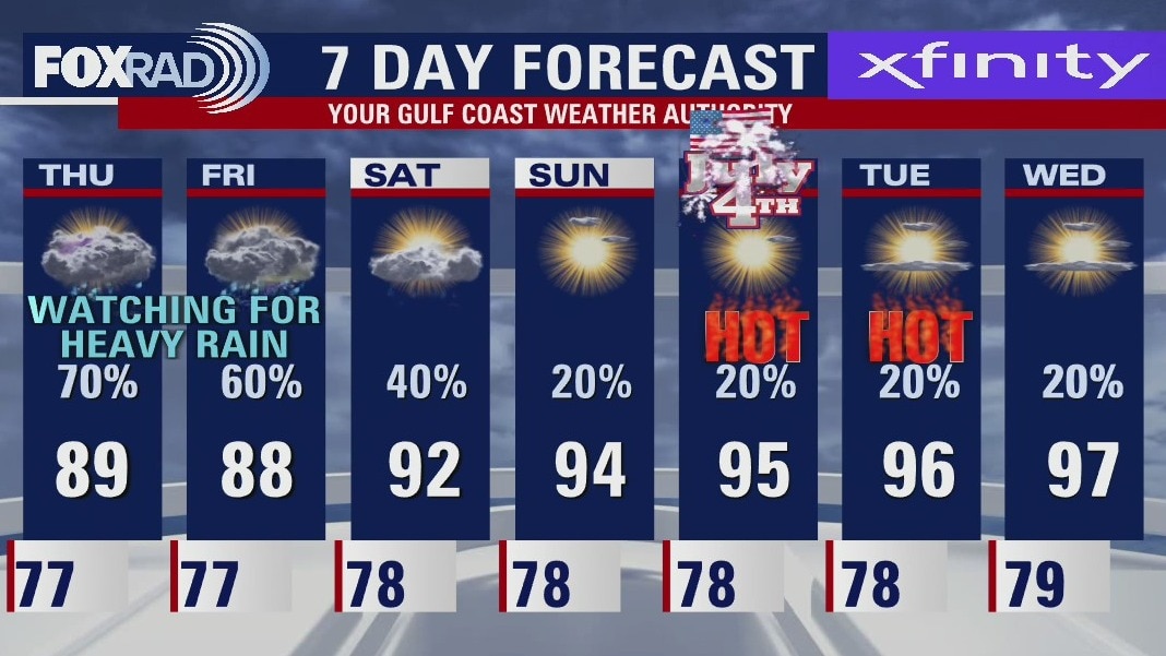
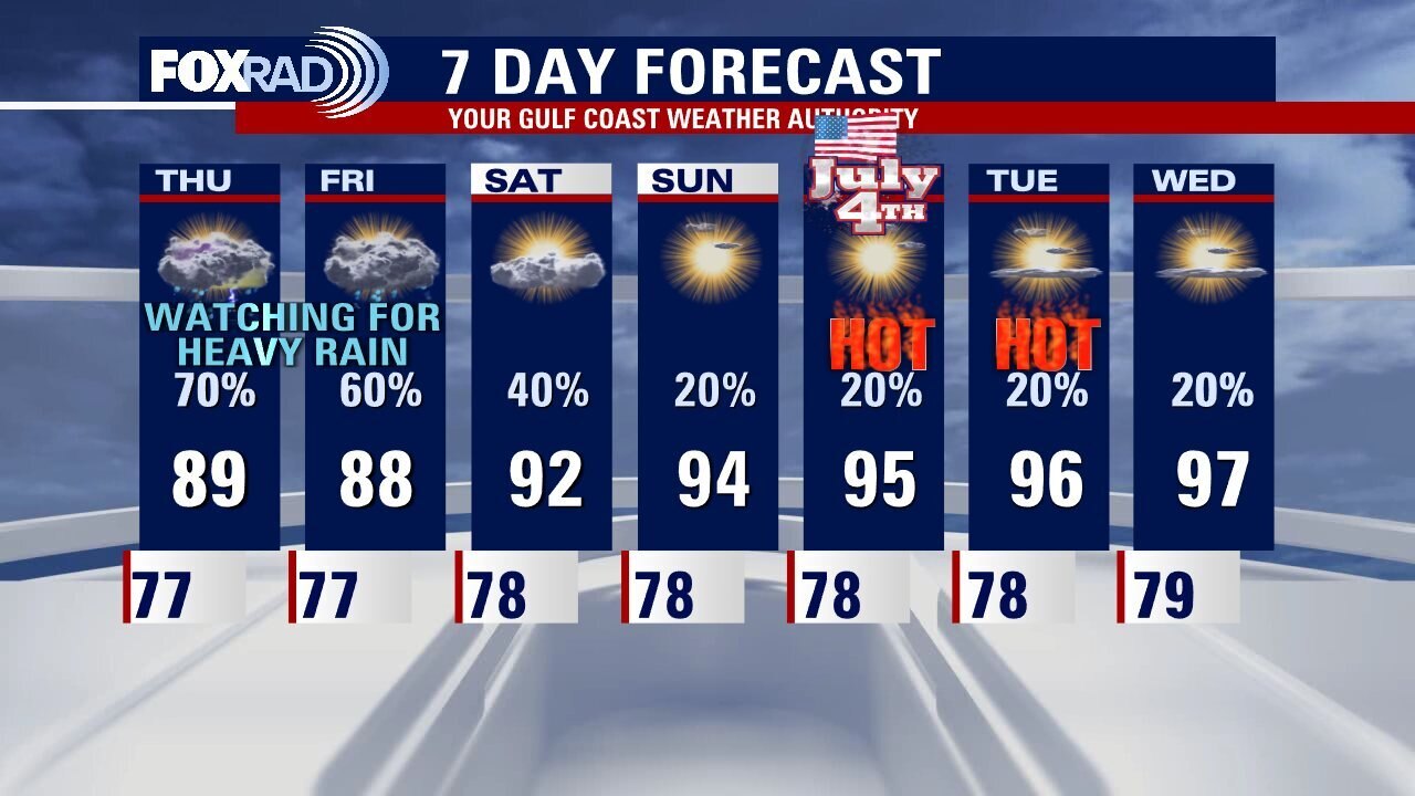
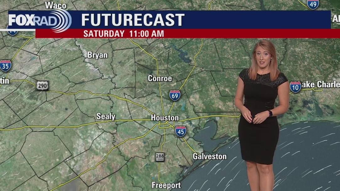
Partly sunny Wednesday, scattered storms possible later
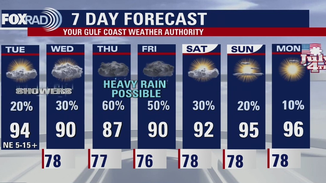
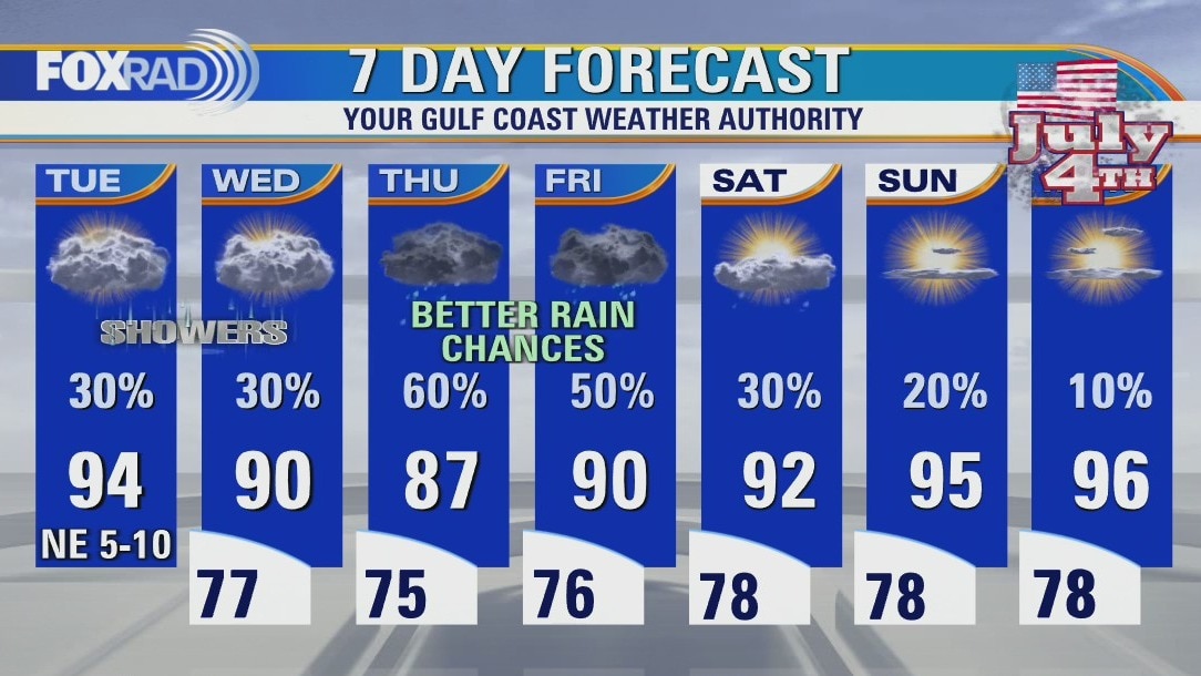
Wednesday starts with a decent amount of sunshine with clouds and rain chances increasing throughout the day. Our best chances for widespread rain remain Thursday and Friday, pending how this area of low pressure tracks. Saturday looks to be the "soggiest" of the long holiday weekend though thundershowers will be hit or miss. But keep that in mind for outdoor plans! By Monday, mostly sunny skies and warmer temperatures.
Wednesday starts with a decent amount of sunshine with clouds and rain chances increasing throughout the day. Our best chances for widespread rain remain Thursday and Friday, pending how this area of low pressure tracks. Saturday looks to be the "soggiest" of the long holiday weekend though thundershowers will be hit or miss. But keep that in mind for outdoor plans! By Monday, mostly sunny skies and warmer temperatures.
Wednesday morning weather forecast
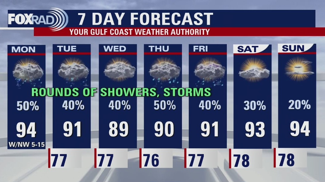
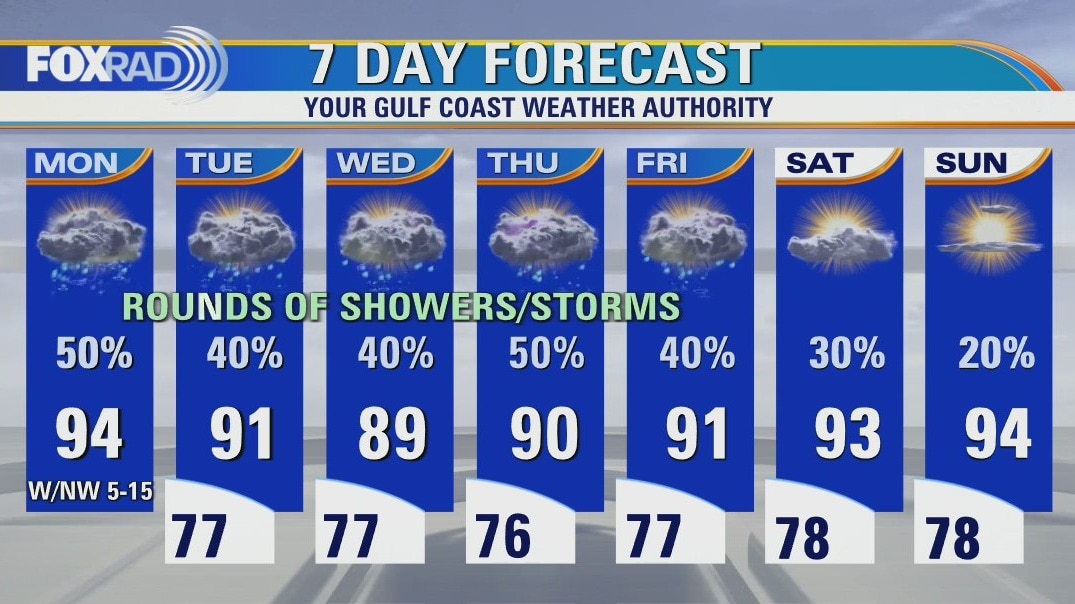
Houston will continue to watch a low in the Gulf. The National Hurricane Center gives it a 40% chance to develop into a tropical depression or storm. Its organization, track, and intensity will determine the amount of rain expected for southeast Texas on Thursday and Friday. For now, it looks like the dry ground can handle all the rain without widespread problems. Things should dry over the weekend and July 4th looks muggy and hot.
Houston will continue to watch a low in the Gulf. The National Hurricane Center gives it a 40% chance to develop into a tropical depression or storm. Its organization, track, and intensity will determine the amount of rain expected for southeast Texas on Thursday and Friday. For now, it looks like the dry ground can handle all the rain without widespread problems. Things should dry over the weekend and July 4th looks muggy and hot.
Tuesday evening weather forecast
Houston will continue to watch a low in the Gulf. The National Hurricane Center gives it a 40% chance to develop into a tropical depression or storm. Its organization, track, and intensity will determine the amount of rain expected for southeast Texas on Thursday and Friday. For now, it looks like the dry ground can handle all the rain without widespread problems. Things should dry over the weekend and July 4th looks muggy and hot.
Houston will continue to watch a low in the Gulf. The National Hurricane Center gives it a 40% chance to develop into a tropical depression or storm. Its organization, track, and intensity will determine the amount of rain expected for southeast Texas on Thursday and Friday. For now, it looks like the dry ground can handle all the rain without widespread problems. Things should dry over the weekend and July 4th looks muggy and hot.
Isolated rain and cooler temperatures on Tuesday afternoon
Rain chances will be isolated for today and most of the day tomorrow, with partly to mostly cloudy skies. Wednesday night into Thursday will be the timeframe to watch for the potential development of a coastal low, that could increase our rain chances. Heading into the holiday weekend, rain chances go down and temperatures go up. Enjoy the cooler temperatures for now, as the heat looks to return post-Independence Day.
Rain chances will be isolated for today and most of the day tomorrow, with partly to mostly cloudy skies. Wednesday night into Thursday will be the timeframe to watch for the potential development of a coastal low, that could increase our rain chances. Heading into the holiday weekend, rain chances go down and temperatures go up. Enjoy the cooler temperatures for now, as the heat looks to return post-Independence Day.
Cloudier on Tuesday, with isolated rain chances
Yesterday's midday clearing allowed us to tap into some good daytime heating leading to convection and some solid downpours. Today and tomorrow look to be both cloudier and cooler, with isolated rain chances. Pending the development or lack there of this coastal low we have been monitoring, rain chances look better for Thursday and Friday. Stick with us for updates and changes, but overall as we head closer to July 4th less fireworks from the sky and more sunshine.
Yesterday's midday clearing allowed us to tap into some good daytime heating leading to convection and some solid downpours. Today and tomorrow look to be both cloudier and cooler, with isolated rain chances. Pending the development or lack there of this coastal low we have been monitoring, rain chances look better for Thursday and Friday. Stick with us for updates and changes, but overall as we head closer to July 4th less fireworks from the sky and more sunshine.
Tuesday morning weather forecast
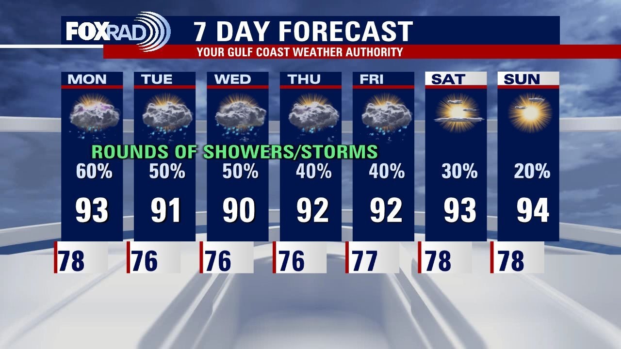
It's nice to see a 7 Day forecast without triple digits for the afternoon highs! Be ready for on and off showers and heavy downpours during this week. Houston will still be in the 90s but most days will be lower 90s. We are still watching the Gulf for tropical development, but chances remain low and impacts are not expected to change much with or without a tropical depression. For now it looks like next week will be back to hot and dry for Southeast Texas.
It's nice to see a 7 Day forecast without triple digits for the afternoon highs! Be ready for on and off showers and heavy downpours during this week. Houston will still be in the 90s but most days will be lower 90s. We are still watching the Gulf for tropical development, but chances remain low and impacts are not expected to change much with or without a tropical depression. For now it looks like next week will be back to hot and dry for Southeast Texas.
Monday evening weather forecast
It's nice to see a 7-Day forecast without triple digits for the afternoon highs! Be ready for on and off showers and heavy downpours during this week. Houston will still be in the 90s but most days will be lower 90s. We are still watching the Gulf for tropical development, but chances remain low and impacts are not expected to change much with or without a tropical depression. For now it looks like next week will be back to hot and dry for Southeast Texas.
It's nice to see a 7-Day forecast without triple digits for the afternoon highs! Be ready for on and off showers and heavy downpours during this week. Houston will still be in the 90s but most days will be lower 90s. We are still watching the Gulf for tropical development, but chances remain low and impacts are not expected to change much with or without a tropical depression. For now it looks like next week will be back to hot and dry for Southeast Texas.
Rain showers give us a break from the heat
Finally a break from the heat and some much needed rain! Plan for on-and-off showers and storms daily through the end of the week, with lows mostly in the 70s and highs mostly in the 90s. The potential development of a coastal low could either boost or decrease our rain chances. Stick with us for updates, but it does look like the holiday weekend is trending both drier and warmer leading into July 4th festivities.
Finally a break from the heat and some much needed rain! Plan for on-and-off showers and storms daily through the end of the week, with lows mostly in the 70s and highs mostly in the 90s. The potential development of a coastal low could either boost or decrease our rain chances. Stick with us for updates, but it does look like the holiday weekend is trending both drier and warmer leading into July 4th festivities.


June 2022 shaping up to be the hottest on record
This June might be the new record holder for overall monthly temperatures as we have already seen five days of 100-degree heat in Houston and a majority of days with above-average highs.
This June might be the new record holder for overall monthly temperatures as we have already seen five days of 100-degree heat in Houston and a majority of days with above-average highs.
Scattered showers Monday morning, another round of rain this afternoon
Finally a break from the heat and some much needed rain! Plan for on and off showers and storms daily through the end of the week, with lows mostly in the 70s and highs mostly in the 90s. The potential development of a coastal low could either boost or decrease our rain chances. Stick with us for updates, but it does look like the holiday weekend is trending both drier and warmer leading into July 4th festivities.
Finally a break from the heat and some much needed rain! Plan for on and off showers and storms daily through the end of the week, with lows mostly in the 70s and highs mostly in the 90s. The potential development of a coastal low could either boost or decrease our rain chances. Stick with us for updates, but it does look like the holiday weekend is trending both drier and warmer leading into July 4th festivities.
Sunday night leading into Monday morning weather forecast
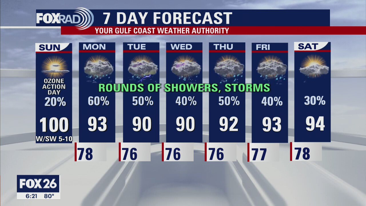
If you love the heat, I hope you enjoyed the weekend because the week ahead is a break in this very warm and dry pattern. The lower 90s and rain chances every day dominate the forecast. It won't be a washout every day, but there will be chances for all of us to see rain. We still are watching for a possible low to form in the Gulf later in the week, but not something to worry about. If it happens, it will just increase the rain chances for the end of the week.
If you love the heat, I hope you enjoyed the weekend because the week ahead is a break in this very warm and dry pattern. The lower 90s and rain chances every day dominate the forecast. It won't be a washout every day, but there will be chances for all of us to see rain. We still are watching for a possible low to form in the Gulf later in the week, but not something to worry about. If it happens, it will just increase the rain chances for the end of the week.
Sunday Morning Forecast with Meteorologist Lena Maria Arango
One last sultry day before we trade our steamy pattern for a soggy one. While it won't be raining all the time every day, everyone has a chance to get in on some action at some point this week and the stalled boundary will also provide a cooldown. An area of low pressure may form in the Gulf from this leftover boundary, but it currently has low chances of developing in the next 2-5 days and if it does form would likely just boost our rain chances if anything. Stay tuned into the forecast this week for updates and changes!
One last sultry day before we trade our steamy pattern for a soggy one. While it won't be raining all the time every day, everyone has a chance to get in on some action at some point this week and the stalled boundary will also provide a cooldown. An area of low pressure may form in the Gulf from this leftover boundary, but it currently has low chances of developing in the next 2-5 days and if it does form would likely just boost our rain chances if anything. Stay tuned into the forecast this week for updates and changes!
Saturday night leading into Sunday morning weather forecast
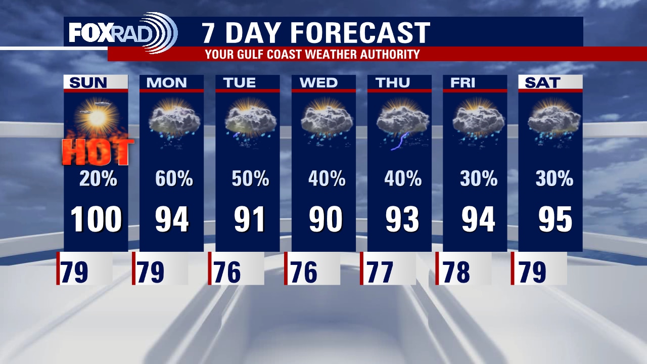
Heat relief is coming but we have to get through one more scorching hot day on Sunday. Highs tomorrow afternoon will again climb to near 100 with mostly sunny skies. A few isolated showers and thunderstorms will be possible late in the day but higher rain chances arrive next week. A weak front will drop into the area on Monday and stall nearby bringing daily rain and storm chances. With a stalled front lingering over the Gulf, there is always a slight chance for a small tropical low to form, so we'll watch that for the middle part of next week.
Heat relief is coming but we have to get through one more scorching hot day on Sunday. Highs tomorrow afternoon will again climb to near 100 with mostly sunny skies. A few isolated showers and thunderstorms will be possible late in the day but higher rain chances arrive next week. A weak front will drop into the area on Monday and stall nearby bringing daily rain and storm chances. With a stalled front lingering over the Gulf, there is always a slight chance for a small tropical low to form, so we'll watch that for the middle part of next week.
Saturday morning weather forecast
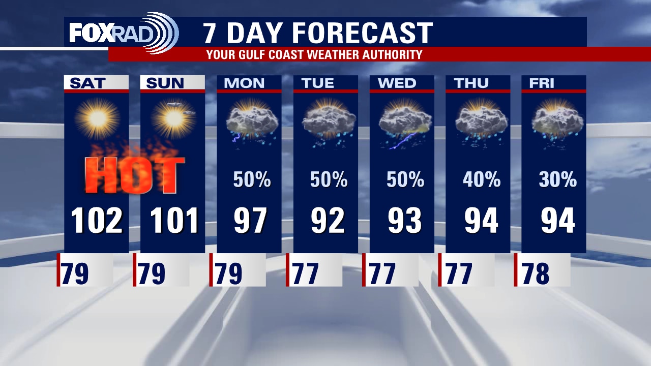
Bright sunshine and dangerously hot temperatures are expected this weekend. Make sure you are taking heat safety precautions seriously and limiting outdoor time. A cold front will push into the region on Monday kicking off an unsettled week. Beneficial rain is on the way with temperatures trending a touch cooler as well.
Bright sunshine and dangerously hot temperatures are expected this weekend. Make sure you are taking heat safety precautions seriously and limiting outdoor time. A cold front will push into the region on Monday kicking off an unsettled week. Beneficial rain is on the way with temperatures trending a touch cooler as well.
Friday evening weather forecast with Meteorologist Adrienne Vonn
Bright sunshine and dangerously hot temperatures are expected this weekend. Make sure you are taking heat safety precautions seriously and limiting outdoor time. A cold front will push into the region on Monday kicking off an unsettled week. Beneficial rain is on the way with temperatures trending a touch cooler as well.
Bright sunshine and dangerously hot temperatures are expected this weekend. Make sure you are taking heat safety precautions seriously and limiting outdoor time. A cold front will push into the region on Monday kicking off an unsettled week. Beneficial rain is on the way with temperatures trending a touch cooler as well.
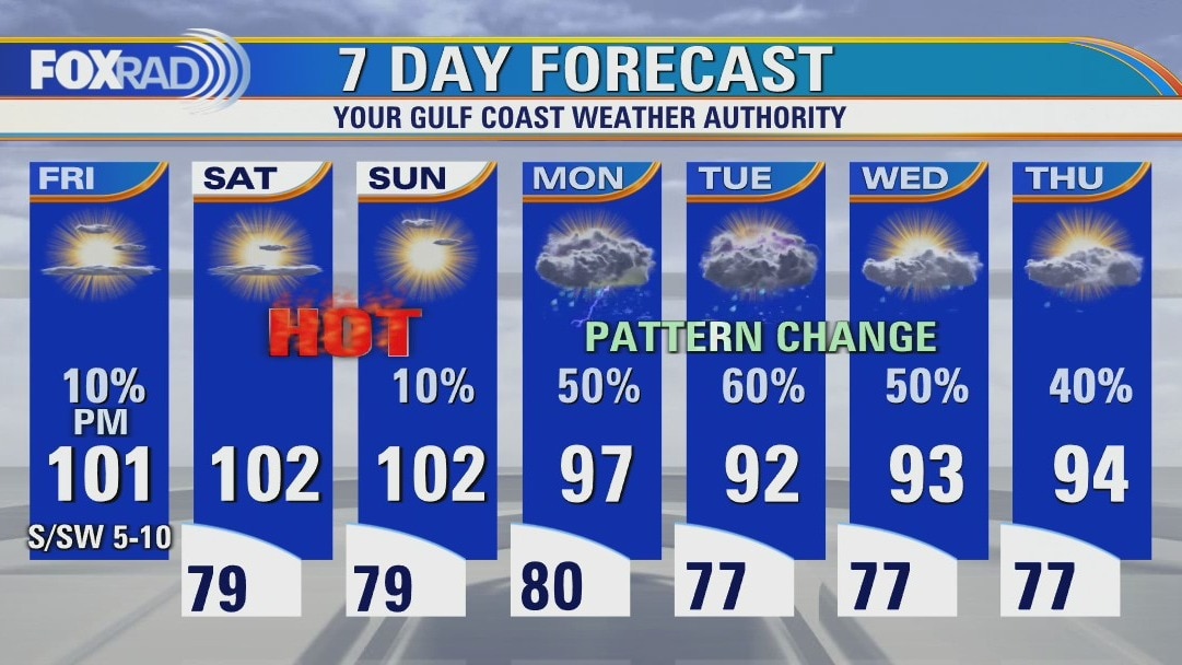
Sunny and hot Friday with highs near 100 and a slight chance for a storm
Strong sunshine, light breezes and near-record high temperatures will remain in place through Sunday, so expect a very hot weekend. Monday looks hot as well, but there is a good chance for storms by the afternoon. Clouds and showers are much more likely along a stalled front for much of next week, so finally we could feel about a 7-10? drop in high temperatures along with much needed rain.
Strong sunshine, light breezes and near-record high temperatures will remain in place through Sunday, so expect a very hot weekend. Monday looks hot as well, but there is a good chance for storms by the afternoon. Clouds and showers are much more likely along a stalled front for much of next week, so finally we could feel about a 7-10? drop in high temperatures along with much needed rain.