

Thursday morning Houston-area weather forecast
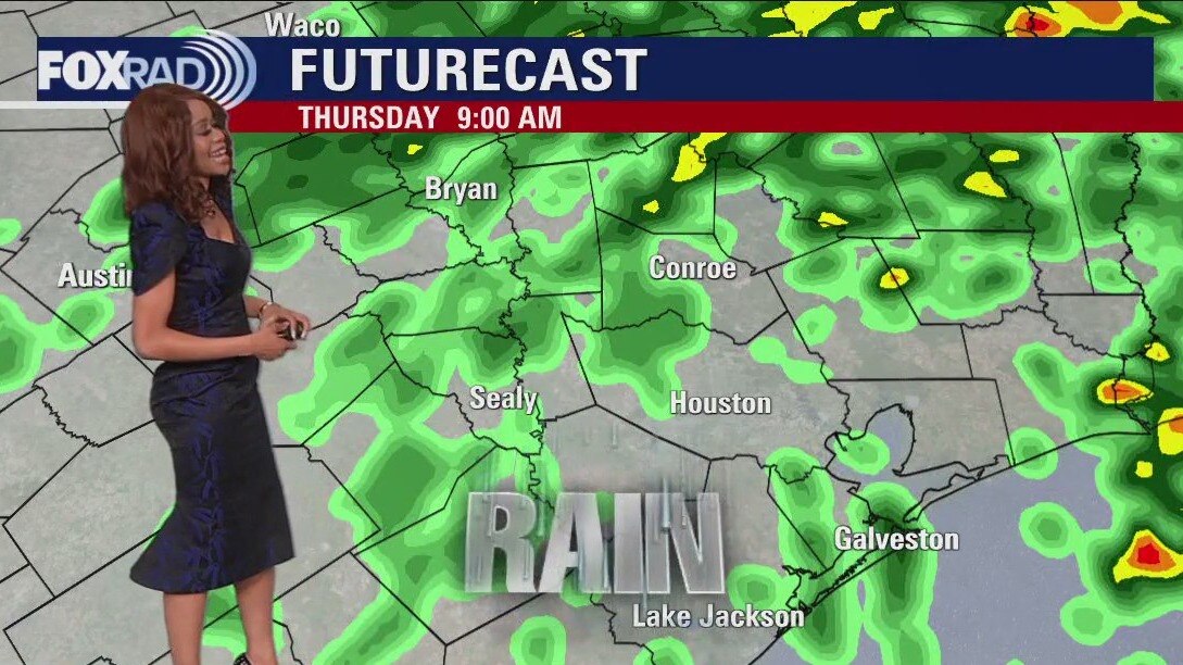
Isolated light icing is still possible NW of Houston up around Washington county where a Winter Weather Advisory has been extended until 6 AM Thursday. Major issues are not expected, but a few icy spots might develop on bridges, sidewalks, etc. Unseasonably cold air sticks around tonight and tomorrow with 30s tonight and 40s Thursday. Rounds of light to moderate rain will move through tonight through Thursday morning, tapering off during Thursday afternoon. There's a slim shot for some flooding issues to pop up especially in areas that have picked up several inches of rain recently. Pattern FINALLY starts to shift by Friday with drier air and more sunshine returning. Temps gradually heat up again with 70s expected by Sunday and Monday.
Isolated light icing is still possible NW of Houston up around Washington county where a Winter Weather Advisory has been extended until 6 AM Thursday. Major issues are not expected, but a few icy spots might develop on bridges, sidewalks, etc. Unseasonably cold air sticks around tonight and tomorrow with 30s tonight and 40s Thursday. Rounds of light to moderate rain will move through tonight through Thursday morning, tapering off during Thursday afternoon. There's a slim shot for some flooding issues to pop up especially in areas that have picked up several inches of rain recently. Pattern FINALLY starts to shift by Friday with drier air and more sunshine returning. Temps gradually heat up again with 70s expected by Sunday and Monday.

Wednesday evening weather forecast with Meteorologist Remeisha Shade
Isolated light icing is still possible NW of Houston up around Washington county where a Winter Weather Advisory has been extended until 6 AM Thursday. Major issues are not expected, but a few icy spots might develop on bridges, sidewalks, etc. Unseasonably cold air sticks around tonight and tomorrow with 30s tonight and 40s Thursday. Rounds of light to moderate rain will move through tonight through Thursday morning, tapering off during Thursday afternoon. There's a slim shot for some flooding issues to pop up, especially in areas that have picked up several inches of rain recently. Pattern FINALLY starts to shift by Friday with drier air and more sunshine returning. Temps gradually heat up again with the 70s expected by Sunday and Monday.
Isolated light icing is still possible NW of Houston up around Washington county where a Winter Weather Advisory has been extended until 6 AM Thursday. Major issues are not expected, but a few icy spots might develop on bridges, sidewalks, etc. Unseasonably cold air sticks around tonight and tomorrow with 30s tonight and 40s Thursday. Rounds of light to moderate rain will move through tonight through Thursday morning, tapering off during Thursday afternoon. There's a slim shot for some flooding issues to pop up, especially in areas that have picked up several inches of rain recently. Pattern FINALLY starts to shift by Friday with drier air and more sunshine returning. Temps gradually heat up again with the 70s expected by Sunday and Monday.
Wednesday afternoon weather forecast with Meteorologist John Dawson
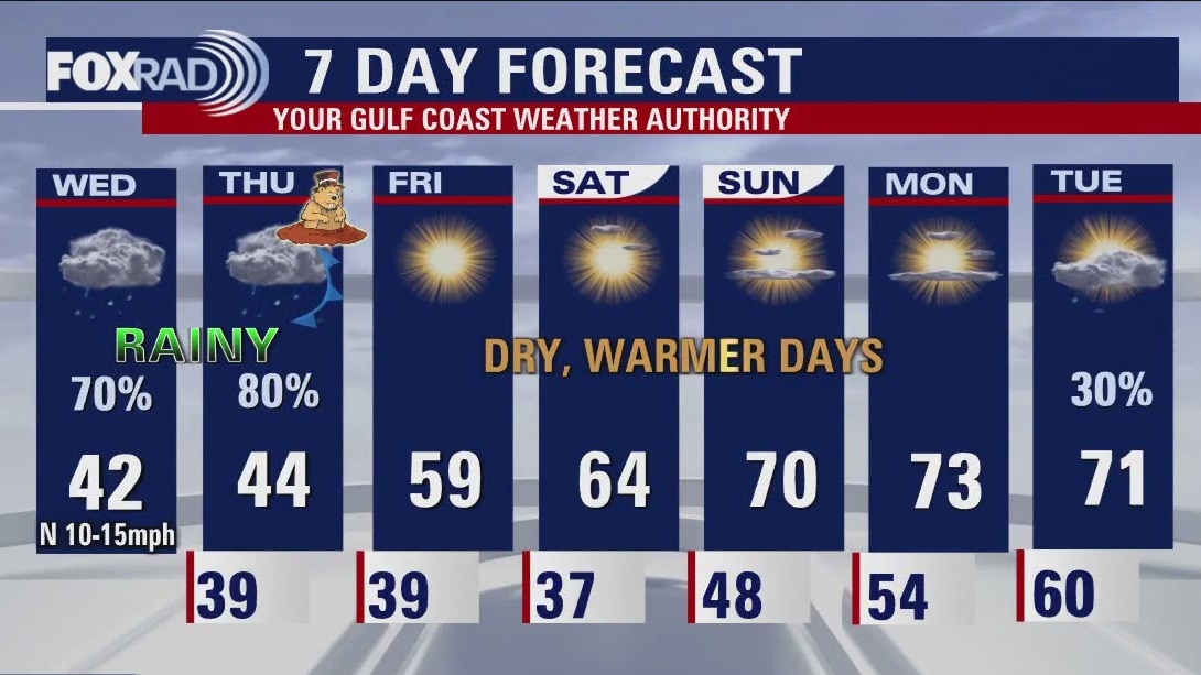
It's going to be a "near miss" for the Houston area for one more day with temperatures, fortunately, remaining above freezing here, but likely stuck near 40 degrees all day. Elsewhere in Texas, travel is at a standstill with dangerous ice covering roads in the north and central Texas. Watch for potential ice from Brenham westward and Huntsville northward. A few sleet pellets could mix in with rain today closer to Houston, but doesn't present a hazard. Expect off-and-on rain today, tonight, and tomorrow with improving conditions Friday through the weekend. In fact, sunshine and highs near 70 will return by Sunday.
It's going to be a "near miss" for the Houston area for one more day with temperatures, fortunately, remaining above freezing here, but likely stuck near 40 degrees all day. Elsewhere in Texas, travel is at a standstill with dangerous ice covering roads in the north and central Texas. Watch for potential ice from Brenham westward and Huntsville northward. A few sleet pellets could mix in with rain today closer to Houston, but doesn't present a hazard. Expect off-and-on rain today, tonight, and tomorrow with improving conditions Friday through the weekend. In fact, sunshine and highs near 70 will return by Sunday.
Houston forecast: Cold, misty and rainy at times on Wednesday
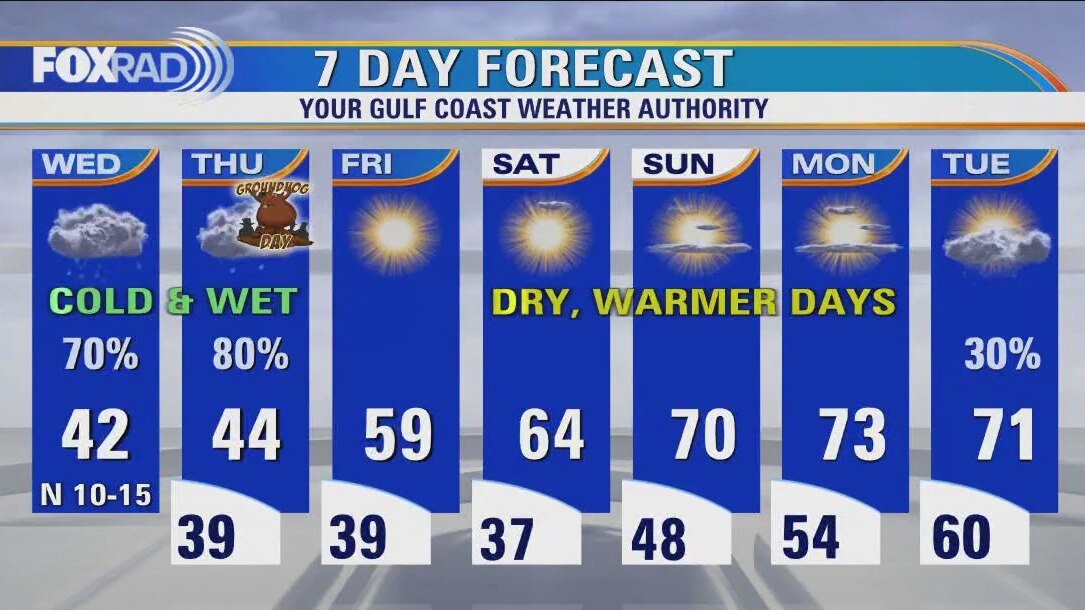
It's going to be a "near miss" for the Houston area for one more day with temperatures fortunately remaining above freezing here, but likely stuck near 40 degrees all day. Elsewhere in Texas, travel is at a standstill with dangerous ice covering roads in north and central Texas. Watch for potential ice from Brenham westward and Huntsville northward. A few sleet pellets could mix in with rain today closer to Houston, but doesn't present a hazard. Expect off and on rain today, tonight and tomorrow with improving conditions Friday through the weekend. In fact, sunshine and highs near 70 will return by Sunday.
It's going to be a "near miss" for the Houston area for one more day with temperatures fortunately remaining above freezing here, but likely stuck near 40 degrees all day. Elsewhere in Texas, travel is at a standstill with dangerous ice covering roads in north and central Texas. Watch for potential ice from Brenham westward and Huntsville northward. A few sleet pellets could mix in with rain today closer to Houston, but doesn't present a hazard. Expect off and on rain today, tonight and tomorrow with improving conditions Friday through the weekend. In fact, sunshine and highs near 70 will return by Sunday.
Wednesday morning Houston-area weather forecast
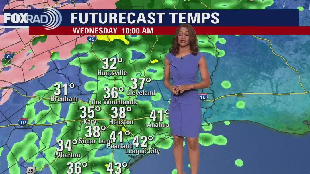
Winter Storm Warning is in effect for Washington county until Noon Wednesday which includes Brenham. Winter Weather Advisory is in place until Noon Wednesday for Walker, Grimes, Waller, Austin & Colorado counties. Expect the chance for a light glaze of ice tonight through Wednesday morning just NW of Houston. Precipitation should be mainly rain for the Houston area. Temperatures will stay chilly the next few days with lows in the 30s and highs in the 40s. Pattern does another major shift heading into the weekend with warmer, brighter & drier weather expected. Enjoy the rest of your week and make sure to download the FOX 26 weather app!
Winter Storm Warning is in effect for Washington county until Noon Wednesday which includes Brenham. Winter Weather Advisory is in place until Noon Wednesday for Walker, Grimes, Waller, Austin & Colorado counties. Expect the chance for a light glaze of ice tonight through Wednesday morning just NW of Houston. Precipitation should be mainly rain for the Houston area. Temperatures will stay chilly the next few days with lows in the 30s and highs in the 40s. Pattern does another major shift heading into the weekend with warmer, brighter & drier weather expected. Enjoy the rest of your week and make sure to download the FOX 26 weather app!

Tuesday evening weather forecast with Meteorologist Remeisha Shade
Winter Storm Warning is in effect for Washington county until Noon Wednesday which includes Brenham. Winter Weather Advisory is in place until Noon Wednesday for Walker, Grimes, Waller, and Austin & Colorado counties. Expect the chance for a light glaze of ice tonight through Wednesday morning just NW of Houston. Precipitation should be mainly rain for the Houston area. Temperatures will stay chilly for the next few days with lows in the 30s and highs in the 40s. The pattern does another major shift heading into the weekend with warmer, brighter & drier weather expected. Enjoy the rest of your week and make sure to download the FOX 26 weather app!
Winter Storm Warning is in effect for Washington county until Noon Wednesday which includes Brenham. Winter Weather Advisory is in place until Noon Wednesday for Walker, Grimes, Waller, and Austin & Colorado counties. Expect the chance for a light glaze of ice tonight through Wednesday morning just NW of Houston. Precipitation should be mainly rain for the Houston area. Temperatures will stay chilly for the next few days with lows in the 30s and highs in the 40s. The pattern does another major shift heading into the weekend with warmer, brighter & drier weather expected. Enjoy the rest of your week and make sure to download the FOX 26 weather app!
Tuesday afternoon weather forecast with Meteorologist John Dawson
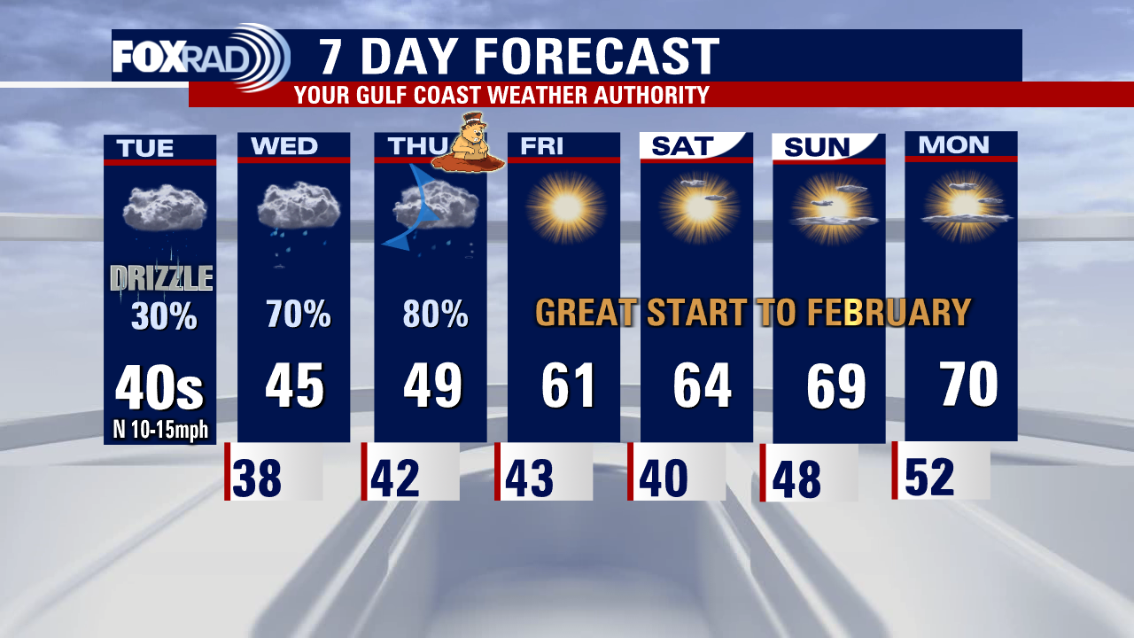
Brace yourself for a cold, blustery, and misty day with a chance for some light ice forming from Huntsville to Hempstead and surrounding areas through noon tomorrow. High temperatures may be stuck in the low 40s today and tomorrow with increasing chances for heavier rain by Wednesday and Thursday. Much of Texas including Dallas, Austin, and just about all of Central Texas icing over and travel will be treacherous and flights could be delayed. Sunshine and warmer days will arrive from Friday through this weekend.
Brace yourself for a cold, blustery, and misty day with a chance for some light ice forming from Huntsville to Hempstead and surrounding areas through noon tomorrow. High temperatures may be stuck in the low 40s today and tomorrow with increasing chances for heavier rain by Wednesday and Thursday. Much of Texas including Dallas, Austin, and just about all of Central Texas icing over and travel will be treacherous and flights could be delayed. Sunshine and warmer days will arrive from Friday through this weekend.
Houston weather: Cloudy, cold Tuesday with light showers
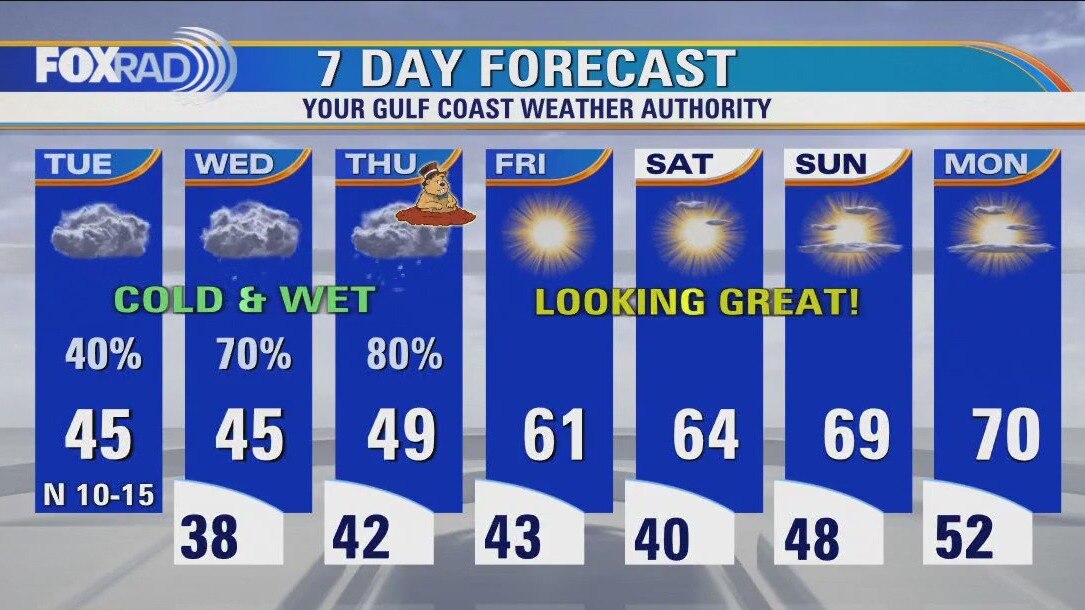
Brace yourself for a cold, blustery and misty day with a chance for some light ice forming from Huntsville to Hempstead and surrounding areas through noon tomorrow. High temperatures may be stuck in the low 40s today and tomorrow with increasing chances for heavier rain by Wednesday and Thursday. Much of Texas including Dallas, Austin and just about all of Central Texas are icing over and travel will be treacherous and flights could be delayed. Sunshine and warmer days will arrive for Friday through this weekend.
Brace yourself for a cold, blustery and misty day with a chance for some light ice forming from Huntsville to Hempstead and surrounding areas through noon tomorrow. High temperatures may be stuck in the low 40s today and tomorrow with increasing chances for heavier rain by Wednesday and Thursday. Much of Texas including Dallas, Austin and just about all of Central Texas are icing over and travel will be treacherous and flights could be delayed. Sunshine and warmer days will arrive for Friday through this weekend.
Tuesday morning Houston-area weather forecast
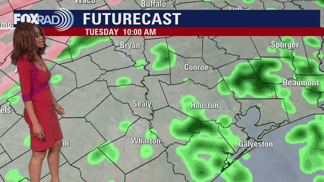
Winter weather has returned to SE Texas with around a 30 degree temperature drop since Sunday! Fog & a few light rain showers are possible tonight with a light glaze of ice also possible up in Washington county. So if you are around the Brenham area, prepare for the possibility of some slick roads in the morning, especially bridges & overpasses. Tuesday will be another cool day with some spotty light rain for much of the area. Temperatures will likely not get out of the 40s. Heading into Wednesday & Thursday, temperatures will remain cool but rain will get heavier as another system moves in. The flood threat will increase again since we've had so much rain recently. Fortunately, we dry out with more sun & milder temperatures expected for the weekend.
Winter weather has returned to SE Texas with around a 30 degree temperature drop since Sunday! Fog & a few light rain showers are possible tonight with a light glaze of ice also possible up in Washington county. So if you are around the Brenham area, prepare for the possibility of some slick roads in the morning, especially bridges & overpasses. Tuesday will be another cool day with some spotty light rain for much of the area. Temperatures will likely not get out of the 40s. Heading into Wednesday & Thursday, temperatures will remain cool but rain will get heavier as another system moves in. The flood threat will increase again since we've had so much rain recently. Fortunately, we dry out with more sun & milder temperatures expected for the weekend.

Monday evening weather forecast with Meteorologist Remeisha Shade
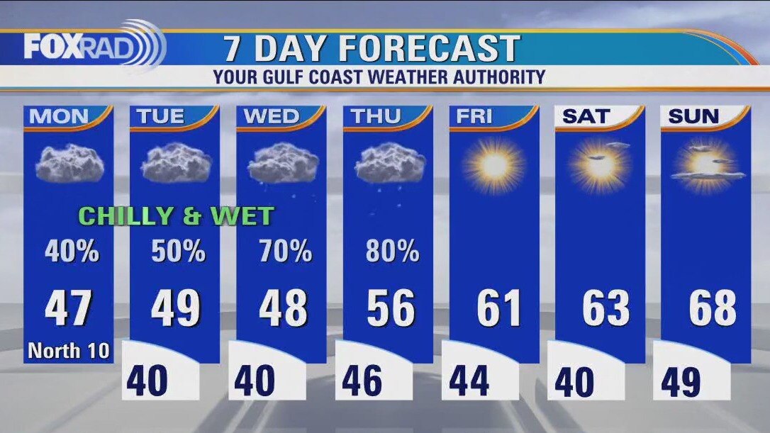
Winter weather has returned to SE Texas with around a 30-degree temperature drop since Sunday! Fog & a few light rain showers are possible tonight with a light glaze of ice also possible up in Washington county. So if you are around the Brenham area, prepare for the possibility of some slick roads in the morning, especially bridges & overpasses. Tuesday will be another cool day with some spotty light rain for much of the area. Temperatures will likely not get out of the 40s. Heading into Wednesday & Thursday, temperatures will remain cool but rain will get heavier as another system moves in. The flood threat will increase again since we've had so much rain recently. Fortunately, we dry out with more sun & milder temperatures expected for the weekend.
Winter weather has returned to SE Texas with around a 30-degree temperature drop since Sunday! Fog & a few light rain showers are possible tonight with a light glaze of ice also possible up in Washington county. So if you are around the Brenham area, prepare for the possibility of some slick roads in the morning, especially bridges & overpasses. Tuesday will be another cool day with some spotty light rain for much of the area. Temperatures will likely not get out of the 40s. Heading into Wednesday & Thursday, temperatures will remain cool but rain will get heavier as another system moves in. The flood threat will increase again since we've had so much rain recently. Fortunately, we dry out with more sun & milder temperatures expected for the weekend.
Houston weather: Cloudy & cold Monday with areas of drizzle
We are stuck in a cold, cloudy and wet pattern through Thursday. Temperatures is most areas inland will remain in the 40s and low 50s each day and overnight lows will reach the upper 30s and low 40s along with rounds of showers. Areas well north and west of Houston closer to College Station, Austin and Dallas will have a risk for freezing rain and sleet that may cause major travel issues. Watch for heavy rain locally on Wednesday and Thursday followed by the return of Sunshine and dry air Friday through the weekend.
We are stuck in a cold, cloudy and wet pattern through Thursday. Temperatures is most areas inland will remain in the 40s and low 50s each day and overnight lows will reach the upper 30s and low 40s along with rounds of showers. Areas well north and west of Houston closer to College Station, Austin and Dallas will have a risk for freezing rain and sleet that may cause major travel issues. Watch for heavy rain locally on Wednesday and Thursday followed by the return of Sunshine and dry air Friday through the weekend.
Monday morning Houston-area weather forecast
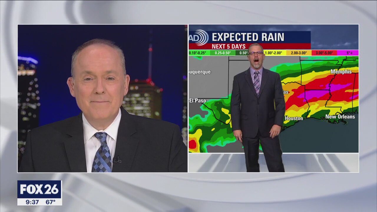
The cold front that brought showers and downpours on Sunday stalled along the coast and will keep rain in the forecast for the start of the work week. Monday looks dreary and cool as colder air continues to move into Southeast Texas. Another front arrives on Thursday with the possibility of stronger storms when it arrives to Houston.
The cold front that brought showers and downpours on Sunday stalled along the coast and will keep rain in the forecast for the start of the work week. Monday looks dreary and cool as colder air continues to move into Southeast Texas. Another front arrives on Thursday with the possibility of stronger storms when it arrives to Houston.
Sunday evening Houston-weather forecast
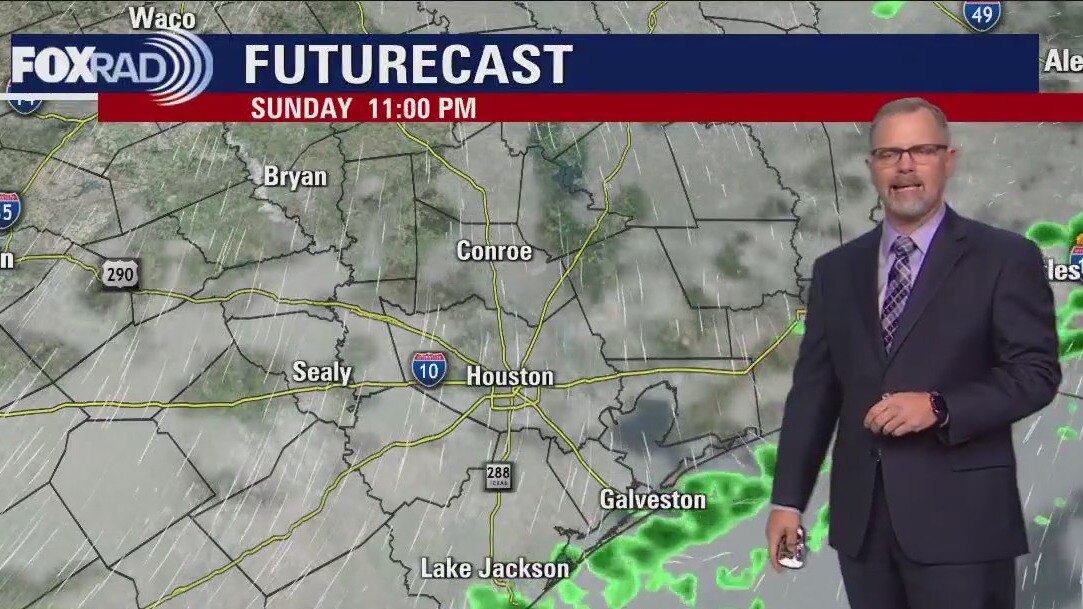
The cold front that brought showers and downpours on Sunday stalled along the coast and will keep rain in the forecast for the start of the work week. Monday looks dreary and cool as colder air continues to move into Southeast Texas. Another front arrives on Thursday with the possibility of stronger storms when it arrives to Houston.
The cold front that brought showers and downpours on Sunday stalled along the coast and will keep rain in the forecast for the start of the work week. Monday looks dreary and cool as colder air continues to move into Southeast Texas. Another front arrives on Thursday with the possibility of stronger storms when it arrives to Houston.

Houston weather: Heavy rainfall, possible severe storms expected for Sunday
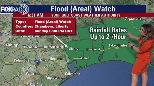
While today is not a repeat of Tuesday, locally heavy rainfall and strong to severe storms are possible. The front makes it to the coast, but stalls leading to periods of rain all week. Monday will be cloudy, drizzly and chilly with temperatures likely falling throughout the day as northwest winds take over. Rain chances then build again as we make our way toward our next front on Thursday. Post-frontal weather looks fantastic for the weekend, with sunshine returning.
While today is not a repeat of Tuesday, locally heavy rainfall and strong to severe storms are possible. The front makes it to the coast, but stalls leading to periods of rain all week. Monday will be cloudy, drizzly and chilly with temperatures likely falling throughout the day as northwest winds take over. Rain chances then build again as we make our way toward our next front on Thursday. Post-frontal weather looks fantastic for the weekend, with sunshine returning.

Houston weather: Heavy rainfall, possible severe storms expected for Sunday
While today is not a repeat of Tuesday, locally heavy rainfall and strong to severe storms are possible. The front makes it to the coast, but stalls leading to periods of rain all week. Monday will be cloudy, drizzly and chilly with temperatures likely falling throughout the day as northwest winds take over. Rain chances then build again as we make our way toward our next front on Thursday. Post-frontal weather looks fantastic for the weekend, with sunshine returning.
While today is not a repeat of Tuesday, locally heavy rainfall and strong to severe storms are possible. The front makes it to the coast, but stalls leading to periods of rain all week. Monday will be cloudy, drizzly and chilly with temperatures likely falling throughout the day as northwest winds take over. Rain chances then build again as we make our way toward our next front on Thursday. Post-frontal weather looks fantastic for the weekend, with sunshine returning.
Houston weather: Rainy pattern in Southeast Texas
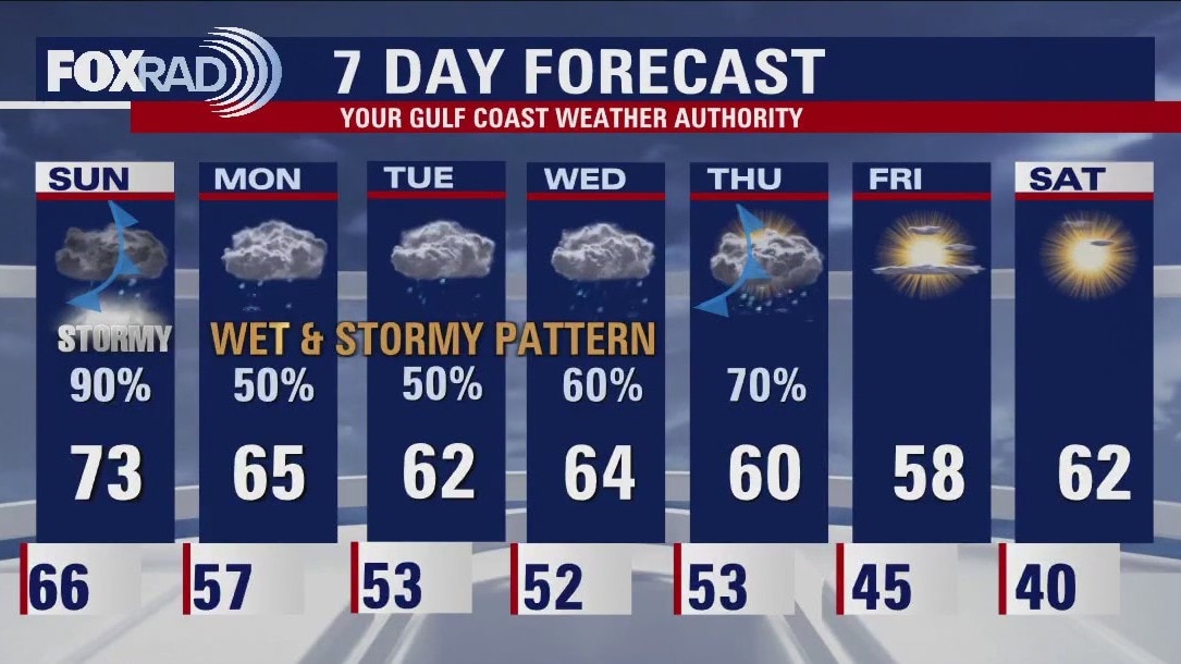
Tomorrow starts a rainy pattern that will be around Southeast Texas for several days. Sunday will see rounds of heavy rain during most of the day with some stronger storms moving through with a front in the afternoon. That front stalls and keep rain in the forecast. Everyday won't be a washout, but some days will see heavy downpours mixed in with showers.
Tomorrow starts a rainy pattern that will be around Southeast Texas for several days. Sunday will see rounds of heavy rain during most of the day with some stronger storms moving through with a front in the afternoon. That front stalls and keep rain in the forecast. Everyday won't be a washout, but some days will see heavy downpours mixed in with showers.

Saturday morning weather forecast with Meteorologist Lena Maria Arango
Saturday will feature light, scattered showers mainly in the first half of the day with a lull in activity in the afternoon/evening. Early Sunday morning, rain returns with more potency, with several pushes of locally heavy rain and the potential for strong to severe storms through the afternoon. That front then stalls, keeping us unsettled through at least Thursday. Several days of rain could lead to issues from time to time, so allow for plenty of extra time to navigate the roadways this week and stick with us for updates.
Saturday will feature light, scattered showers mainly in the first half of the day with a lull in activity in the afternoon/evening. Early Sunday morning, rain returns with more potency, with several pushes of locally heavy rain and the potential for strong to severe storms through the afternoon. That front then stalls, keeping us unsettled through at least Thursday. Several days of rain could lead to issues from time to time, so allow for plenty of extra time to navigate the roadways this week and stick with us for updates.
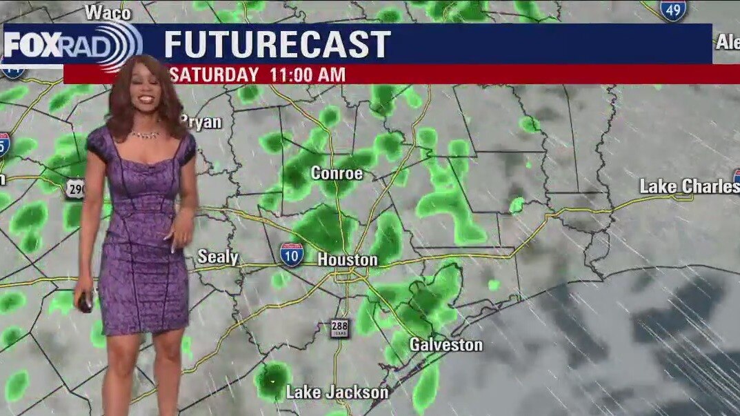
Saturday morning Houston-area weather forecast
We are in the process of transitioning into a cloudy, wet and at times stormy weather pattern. Stay alert over the weekend with the increased risk for flooding, especially Sunday. Tonight will still be cool with a few showers moving in. Rain increases for Saturday along with warmer temperatures near 70. Sunday as a front approaches, heavy downpours will become more likely along with a few strong storms. We are in a Category 1 out of 5 Marginal Risk for severe weather Sunday with isolated damaging wind gusts possible. There's also a higher threat for excessive rain which means flood threat will increase. I expect 1-3" of rain this weekend. More waves of rain will continue Monday through Wednesday. Showers should finally wind down late Thursday as cooler air moves in.
We are in the process of transitioning into a cloudy, wet and at times stormy weather pattern. Stay alert over the weekend with the increased risk for flooding, especially Sunday. Tonight will still be cool with a few showers moving in. Rain increases for Saturday along with warmer temperatures near 70. Sunday as a front approaches, heavy downpours will become more likely along with a few strong storms. We are in a Category 1 out of 5 Marginal Risk for severe weather Sunday with isolated damaging wind gusts possible. There's also a higher threat for excessive rain which means flood threat will increase. I expect 1-3" of rain this weekend. More waves of rain will continue Monday through Wednesday. Showers should finally wind down late Thursday as cooler air moves in.
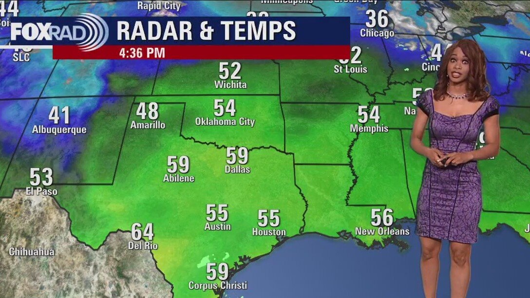
Cloudy, cool Friday evening in the 50s
We are in the process of transitioning into a cloudy, wet and at times stormy weather pattern. Stay alert over the weekend with the increased risk for flooding, especially Sunday. Tonight will still be cool with a few showers moving in. Rain increases for Saturday along with warmer temperatures near 70. Sunday as a front approaches, heavy downpours will become more likely along with a few strong storms. We are in a Category 1 out of 5 Marginal Risk for severe weather Sunday with isolated damaging wind gusts possible. There's also a higher threat for excessive rain which means flood threat will increase. I expect 1-3" of rain this weekend. More waves of rain will continue Monday through Wednesday. Showers should finally wind down late Thursday as cooler air moves in.
We are in the process of transitioning into a cloudy, wet and at times stormy weather pattern. Stay alert over the weekend with the increased risk for flooding, especially Sunday. Tonight will still be cool with a few showers moving in. Rain increases for Saturday along with warmer temperatures near 70. Sunday as a front approaches, heavy downpours will become more likely along with a few strong storms. We are in a Category 1 out of 5 Marginal Risk for severe weather Sunday with isolated damaging wind gusts possible. There's also a higher threat for excessive rain which means flood threat will increase. I expect 1-3" of rain this weekend. More waves of rain will continue Monday through Wednesday. Showers should finally wind down late Thursday as cooler air moves in.
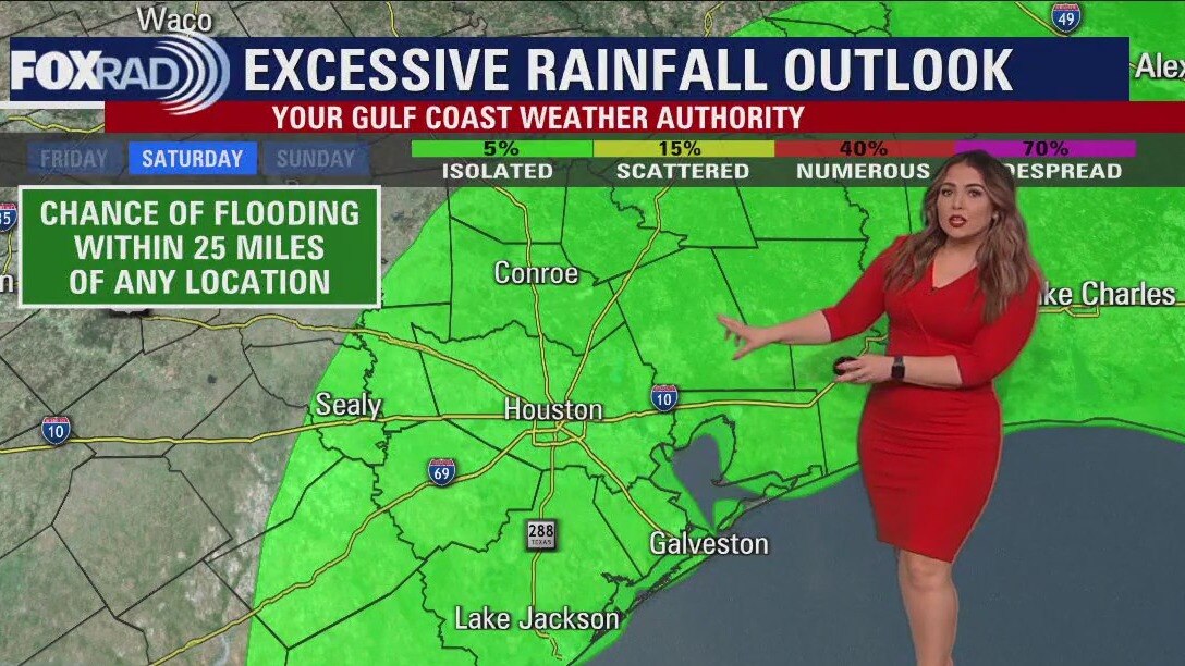
Cloudy, breezy Friday afternoon in the low 60s
Today is a transition day toward a milder, more humid and unsettled pattern that will carry us through much of next week. Though scattered showers will be around pretty much each day, they look to be mostly light to moderate. Sunday will need to be watched a little more closely for the possibility of locally heavy rainfall and a few stronger storms.
Today is a transition day toward a milder, more humid and unsettled pattern that will carry us through much of next week. Though scattered showers will be around pretty much each day, they look to be mostly light to moderate. Sunday will need to be watched a little more closely for the possibility of locally heavy rainfall and a few stronger storms.