


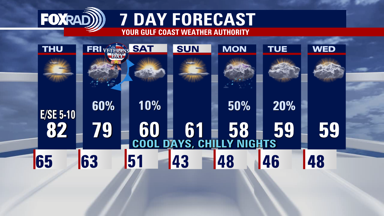
Mostly sunny and mild Thursday, then cold front arrives Friday
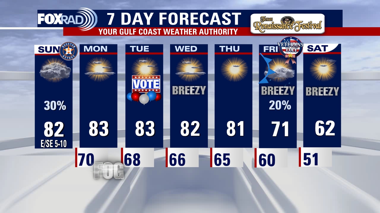
Today's weather looks nice and quiet again, but we have big changes on the way. After highs in the low 80s today, a pretty strong cold front will arrive by Veterans Day evening, so rain is likely and chilly air will follow. This weekend will be much cooler, then another disturbance in the jet stream could bring a rainy, cold day on Monday.
Today's weather looks nice and quiet again, but we have big changes on the way. After highs in the low 80s today, a pretty strong cold front will arrive by Veterans Day evening, so rain is likely and chilly air will follow. This weekend will be much cooler, then another disturbance in the jet stream could bring a rainy, cold day on Monday.

Wednesday night leading into Thursday morning weather forecast with Meteorologist Remeisha Shade
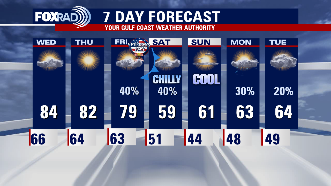
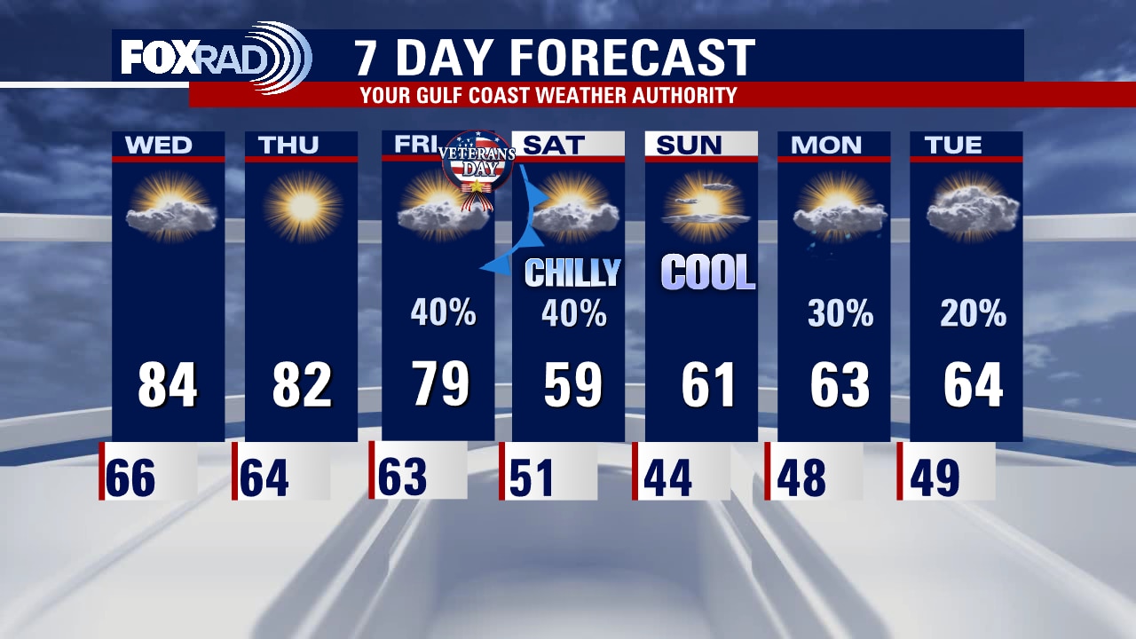
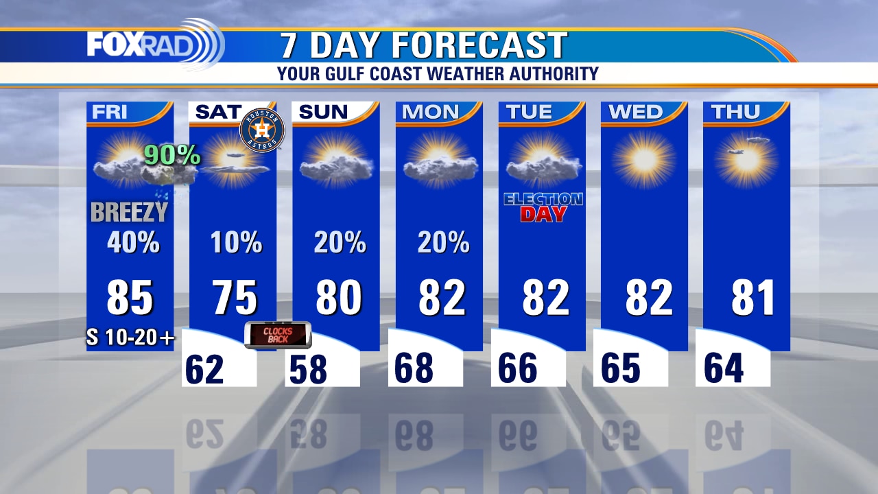
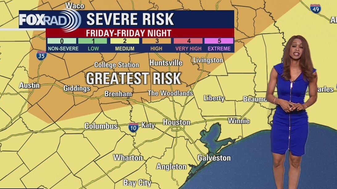
We get a few more warm days before we are reminded that Thanksgiving is right around the corner! Temperatures will soar to near 80 Thursday and Friday before crashing about 20 degrees for your weekend plans! Warm and mainly dry weather is expected for Thursday. But a cold front will bring in a decent shot for scattered showers and a few thunderstorms for Friday PM through early Saturday. Severe weather is not expected but plan on some heavy downpours Friday evening. Chilly air rolls in for the weekend with highs only near 60 and overnight lows in the 30s and 40s. Hurricane Nicole is expected to make landfall overnight in Florida north of West Palm Beach as a Category 1.
We get a few more warm days before we are reminded that Thanksgiving is right around the corner! Temperatures will soar to near 80 Thursday and Friday before crashing about 20 degrees for your weekend plans! Warm and mainly dry weather is expected for Thursday. But a cold front will bring in a decent shot for scattered showers and a few thunderstorms for Friday PM through early Saturday. Severe weather is not expected but plan on some heavy downpours Friday evening. Chilly air rolls in for the weekend with highs only near 60 and overnight lows in the 30s and 40s. Hurricane Nicole is expected to make landfall overnight in Florida north of West Palm Beach as a Category 1.
Wednesday evening weather forecast with Meteorologist Remeisha Shade
We get a few more warm days before we are reminded that Thanksgiving is right around the corner! Temperatures will soar to near 80 Thursday and Friday before crashing about 20 degrees for your weekend plans! Warm and mainly dry weather is expected for Thursday. But a cold front will bring in a decent shot for scattered showers and a few thunderstorms for Friday PM through early Saturday. Severe weather is not expected but plan on some heavy downpours Friday evening. Chilly air rolls in for the weekend with highs only near 60 and overnight lows in the 30s and 40s. Tropical Storm Nicole is expected to make landfall overnight in Florida north of West Palm Beach as a Category 1 hurricane.
We get a few more warm days before we are reminded that Thanksgiving is right around the corner! Temperatures will soar to near 80 Thursday and Friday before crashing about 20 degrees for your weekend plans! Warm and mainly dry weather is expected for Thursday. But a cold front will bring in a decent shot for scattered showers and a few thunderstorms for Friday PM through early Saturday. Severe weather is not expected but plan on some heavy downpours Friday evening. Chilly air rolls in for the weekend with highs only near 60 and overnight lows in the 30s and 40s. Tropical Storm Nicole is expected to make landfall overnight in Florida north of West Palm Beach as a Category 1 hurricane.
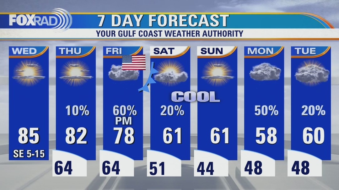
Partly cloudy Wednesday with highs in the mid 80s
A strong cold front is on the way for Veterans Day that should bring rain by the evening followed by a significant drop in temperatures. Highs today and Thursday will reach the low to mid 80s, then following Friday's front, highs this weekend could stay below 60. Next week looks chilly with lows in the 40s. Meanwhile, there is a wild mix of weather across the country with hurricane warnings in effect for Florida and blizzard warnings for the Dakotas.
A strong cold front is on the way for Veterans Day that should bring rain by the evening followed by a significant drop in temperatures. Highs today and Thursday will reach the low to mid 80s, then following Friday's front, highs this weekend could stay below 60. Next week looks chilly with lows in the 40s. Meanwhile, there is a wild mix of weather across the country with hurricane warnings in effect for Florida and blizzard warnings for the Dakotas.
Wednesday morning weather forecast with Meteorologist Remeisha Shade
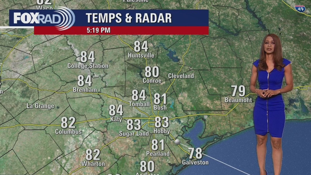
Our temperatures will be dipping to the middle to upper 60s early Wednesday. We remain warm and dry the next few days with rain returning with a cold front Friday PM. Rain lingers early Saturday but no severe weather is expected with this system. However, a big surge of chilly air arrives just in time for your weekend plans so prepare now!
Our temperatures will be dipping to the middle to upper 60s early Wednesday. We remain warm and dry the next few days with rain returning with a cold front Friday PM. Rain lingers early Saturday but no severe weather is expected with this system. However, a big surge of chilly air arrives just in time for your weekend plans so prepare now!
Election Day evening weather forecast with Meteorolgist Remeisha Shade
For folks heading out to the polls this evening, the weather should be pretty quiet with only a slim chance for a stray shower. It will be a warm evening with temperatures near 80 through early tonight and dipping to the middle to upper 60s early Wednesday. We remain warm and dry the next few days with rain returning with a cold front Friday PM. Rain lingers early Saturday but no severe weather is expected with this system. However, a big surge of chilly air arrives just in time for your weekend plans so prepare now!
For folks heading out to the polls this evening, the weather should be pretty quiet with only a slim chance for a stray shower. It will be a warm evening with temperatures near 80 through early tonight and dipping to the middle to upper 60s early Wednesday. We remain warm and dry the next few days with rain returning with a cold front Friday PM. Rain lingers early Saturday but no severe weather is expected with this system. However, a big surge of chilly air arrives just in time for your weekend plans so prepare now!
Mild Tuesday morning with patchy fog, then partly cloudy and warm
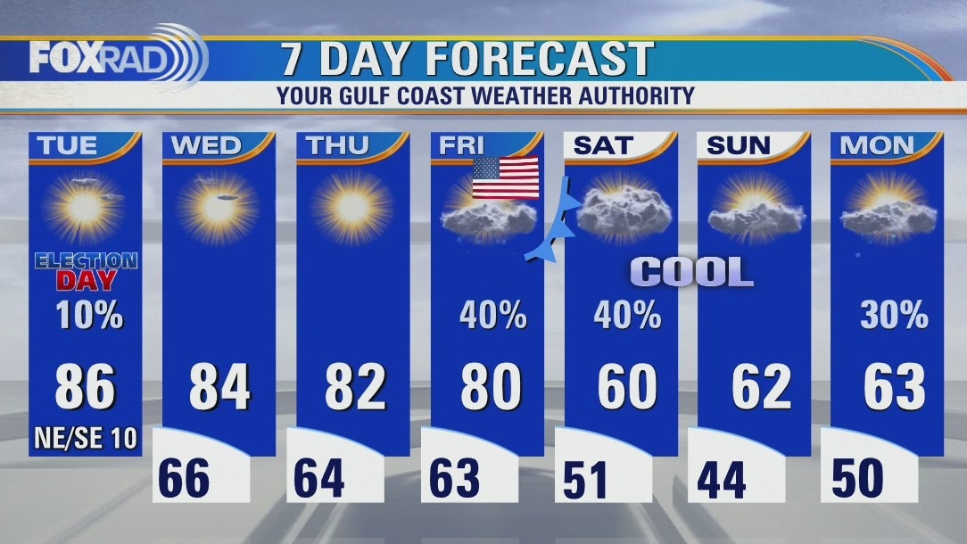
Our weather looks spring-like for Election Day with highs in the mid 80s along with pleasant weather through Thursday. A cold front is expected late Friday/Veterans day, so showers are likely followed by chilly air for the weekend.
Our weather looks spring-like for Election Day with highs in the mid 80s along with pleasant weather through Thursday. A cold front is expected late Friday/Veterans day, so showers are likely followed by chilly air for the weekend.

Election Day Morning Forecast
Election Day Tuesday may start off with some patchy fog, but rain is expected to be isolated with more warm and humid weather expected. The warmth will continue through Friday when our next cold front will be approaching. It will bring a chance for some rain & a few rumbles of thunder Friday and Saturday along with a significant drop in temperatures just in time for the weekend. We are still closely tracking subtropical storm Nicole in the Atlantic as it nears the Bahamas and the east coast of Florida.
Election Day Tuesday may start off with some patchy fog, but rain is expected to be isolated with more warm and humid weather expected. The warmth will continue through Friday when our next cold front will be approaching. It will bring a chance for some rain & a few rumbles of thunder Friday and Saturday along with a significant drop in temperatures just in time for the weekend. We are still closely tracking subtropical storm Nicole in the Atlantic as it nears the Bahamas and the east coast of Florida.

Monday evening weather forecast with Meteorologist Remeisha Shade
It has been a warm and humid afternoon as we continue to celebrate our World Champion Houston Astros with temps in the 80s. Election Day Tuesday may start off with some patchy fog, but rain is expected to be isolated with more warm and humid weather expected. The warmth will continue through Friday when our next cold front will be approaching. It will bring a chance for some rain & a few rumbles of thunder Friday and Saturday along with a significant drop in temperatures just in time for the weekend. We are still closely tracking subtropical storm Nicole in the Atlantic as it nears the Bahamas and the east coast of Florida.
It has been a warm and humid afternoon as we continue to celebrate our World Champion Houston Astros with temps in the 80s. Election Day Tuesday may start off with some patchy fog, but rain is expected to be isolated with more warm and humid weather expected. The warmth will continue through Friday when our next cold front will be approaching. It will bring a chance for some rain & a few rumbles of thunder Friday and Saturday along with a significant drop in temperatures just in time for the weekend. We are still closely tracking subtropical storm Nicole in the Atlantic as it nears the Bahamas and the east coast of Florida.

Partly cloudy and humid for the Astros parade
Hundreds of thousands of your friends and neighbors will head downtown for what will be a warm, humid, sweaty Astros victory parade. Luckily, rain doesn't look like an issue, but it will be muggy. Election Day looks fine. Our next front arrives on Friday or Saturday.
Hundreds of thousands of your friends and neighbors will head downtown for what will be a warm, humid, sweaty Astros victory parade. Luckily, rain doesn't look like an issue, but it will be muggy. Election Day looks fine. Our next front arrives on Friday or Saturday.

Warm temps in the 80s, isolated showers this Sunday evening
The work week starts off warm with partly cloudy skies. The quiet weather will be perfect for a parade or voting. Muggy mornings remain in the forecast until the next cold front at the end of the week. Friday will also be the next opportunity for showers/storms. Look for a tropical storm or hurricane to also threaten Florida late in the week. Go to the FOX26 YouTube Channel for the latest updates.
The work week starts off warm with partly cloudy skies. The quiet weather will be perfect for a parade or voting. Muggy mornings remain in the forecast until the next cold front at the end of the week. Friday will also be the next opportunity for showers/storms. Look for a tropical storm or hurricane to also threaten Florida late in the week. Go to the FOX26 YouTube Channel for the latest updates.
Sunday weather forecast with Meteorologist Lena Maria
Our Astros are on fire, and that's warming up our temps! We'll start off the week with a few foggy mornings as they let the steam out of Minute Maid Park. Afternoons will be sunny, dry and seasonably warm for much of the week. Our next cold front looks to bring a few showers and breezy conditions heading into the weekend, but mainly a major cooldown. While moisture will be limited, temperatures will take a nosedive for an overwhelming majority of the U.S.
Our Astros are on fire, and that's warming up our temps! We'll start off the week with a few foggy mornings as they let the steam out of Minute Maid Park. Afternoons will be sunny, dry and seasonably warm for much of the week. Our next cold front looks to bring a few showers and breezy conditions heading into the weekend, but mainly a major cooldown. While moisture will be limited, temperatures will take a nosedive for an overwhelming majority of the U.S.
Temps in the 70s, clear skies for Saturday evening
Warm front cross over Houston on Sunday bringing a few showers for Southeast Texas. Look for 80s most of the afternoons this week until a cold front on Friday. If anyone wants to plan a parade in Houston this week, there will be several nice days to do it.
Warm front cross over Houston on Sunday bringing a few showers for Southeast Texas. Look for 80s most of the afternoons this week until a cold front on Friday. If anyone wants to plan a parade in Houston this week, there will be several nice days to do it.

Saturday weather forecast with Meteorologist Lena Maria Arango
A couple of light spotty showers are lingering along the coastline this morning, but otherwise it's a cool and quiet day. Enjoy it, because tomorrow our front returns... this time as a warm one. That'll bring our daytime highs into the 80s for much of next week, paired with a few isolated showers/storms on Sunday. Next week looks mostly dry until later in the week (great parade weather, hint hint). Our next front looks to arrive as we honor our Veterans on Friday, bringing the return of rain chances and a cooldown as we head into the weekend.
A couple of light spotty showers are lingering along the coastline this morning, but otherwise it's a cool and quiet day. Enjoy it, because tomorrow our front returns... this time as a warm one. That'll bring our daytime highs into the 80s for much of next week, paired with a few isolated showers/storms on Sunday. Next week looks mostly dry until later in the week (great parade weather, hint hint). Our next front looks to arrive as we honor our Veterans on Friday, bringing the return of rain chances and a cooldown as we head into the weekend.

Saturday overnight/morning forecast
Our severe storm threat remains elevated across SE Texas through the rest of today and especially tonight. Most of the area remains under a Category 2 out of 5 threat for severe weather with a higher Category 3 out of 5 risk in our northern communities. Between now and 7PM, there will be a threat for a few supercell storms that could produce damaging winds or a brief tornado. Then expect a line of storms to develop that will roll through between 9 PM and 2 AM Saturday. Damaging winds 58+ MPH will be possible with this line. So make sure you have the FOX 26 weather app downloaded and have the alerts for your area turned on. Weather calms down for World Series Game 6 Saturday evening with no rain expected downtown. Election Day Tuesday also looks quiet.
Our severe storm threat remains elevated across SE Texas through the rest of today and especially tonight. Most of the area remains under a Category 2 out of 5 threat for severe weather with a higher Category 3 out of 5 risk in our northern communities. Between now and 7PM, there will be a threat for a few supercell storms that could produce damaging winds or a brief tornado. Then expect a line of storms to develop that will roll through between 9 PM and 2 AM Saturday. Damaging winds 58+ MPH will be possible with this line. So make sure you have the FOX 26 weather app downloaded and have the alerts for your area turned on. Weather calms down for World Series Game 6 Saturday evening with no rain expected downtown. Election Day Tuesday also looks quiet.

Warm, windy, cloudy with temps in the 80s this Friday evening
Our severe storm threat remains elevated across SE Texas through the rest of today and especially tonight. Most of the area remains under a Category 2 out of 5 threat for severe weather with a higher Category 3 out of 5 risk in our northern communities. Between now and 7 p.m., there will be a threat for a few supercell storms that could produce damaging winds or a brief tornado. Then I expect a line of storms to develop that will roll through between 9 p.m. and 2 a.m. Saturday. Damaging winds 58+ MPH will be possible with this line. So make sure you have the FOX 26 Weather app downloaded and have the alerts for your area turned on. Weather calms down for World Series Game 6 Saturday evening with no rain expected downtown. Election Day Tuesday also looks quiet.
Our severe storm threat remains elevated across SE Texas through the rest of today and especially tonight. Most of the area remains under a Category 2 out of 5 threat for severe weather with a higher Category 3 out of 5 risk in our northern communities. Between now and 7 p.m., there will be a threat for a few supercell storms that could produce damaging winds or a brief tornado. Then I expect a line of storms to develop that will roll through between 9 p.m. and 2 a.m. Saturday. Damaging winds 58+ MPH will be possible with this line. So make sure you have the FOX 26 Weather app downloaded and have the alerts for your area turned on. Weather calms down for World Series Game 6 Saturday evening with no rain expected downtown. Election Day Tuesday also looks quiet.

Possible showers as severe weather approaches Friday afternoon
Travel may get implicated, both on the roads and in the skies today as folks head to Houston for game 6 of the World Series. Please be extremely careful if driving especially after dark. Isolated strong to severe storms may pop up locally this afternoon through early evening. Past 10 p.m. or so, the threat shifts to the potential for straight-line damaging winds as the line of storms rolls through. Power outages are likely, along with isolated wind damage and briefly heavy rain/frequent thunder and lightning. Tornado and hail threats are lower for us, but cannot be completely ruled out. After a rocky start to the weekend, the rest of it looks fantastic and we can look forward to celebrating a game 6 win with an extra hour of sleep Sunday morning! The majority of next week will be quiet, sunny, and dry with seasonably warm temperatures.
Travel may get implicated, both on the roads and in the skies today as folks head to Houston for game 6 of the World Series. Please be extremely careful if driving especially after dark. Isolated strong to severe storms may pop up locally this afternoon through early evening. Past 10 p.m. or so, the threat shifts to the potential for straight-line damaging winds as the line of storms rolls through. Power outages are likely, along with isolated wind damage and briefly heavy rain/frequent thunder and lightning. Tornado and hail threats are lower for us, but cannot be completely ruled out. After a rocky start to the weekend, the rest of it looks fantastic and we can look forward to celebrating a game 6 win with an extra hour of sleep Sunday morning! The majority of next week will be quiet, sunny, and dry with seasonably warm temperatures.
Friday morning weather forecast with Chief Meteorologist Mike Iscovitz
Check your FOX 26 weather app throughout the day because scattered storms are expected by late afternoon, then we still expect a line of strong to severe storms between around 10pm and 2am to move through bringing high winds and brief heavy rain. The weekend looks pretty nice with clear, dry weather for Game 6 of the World Series.
Check your FOX 26 weather app throughout the day because scattered storms are expected by late afternoon, then we still expect a line of strong to severe storms between around 10pm and 2am to move through bringing high winds and brief heavy rain. The weekend looks pretty nice with clear, dry weather for Game 6 of the World Series.
Friday morning weather forecast
A few showers may roll through this evening and tonight as moisture increases ahead of our next storm system. The next cold front will arrive Friday night and will bring a round of strong to severe storms with the best chance from 8 pm Friday until 2 am Saturday. Main threat will be 60-70 mph damaging winds that could knock down trees and powerlines. But a tornado or two can't be ruled out so make sure you have the FOX 26 App downloaded and alerts turned on. 1-2 inches of rain will also be likely for some of the area that could elevate the flood threat. After this system moves out, we should dry things out and usher in quiet weather just in time for Game 6 of the World Series at Minute Maid Park. A few showers are possible Monday of next week but Election Day is looking dry.
A few showers may roll through this evening and tonight as moisture increases ahead of our next storm system. The next cold front will arrive Friday night and will bring a round of strong to severe storms with the best chance from 8 pm Friday until 2 am Saturday. Main threat will be 60-70 mph damaging winds that could knock down trees and powerlines. But a tornado or two can't be ruled out so make sure you have the FOX 26 App downloaded and alerts turned on. 1-2 inches of rain will also be likely for some of the area that could elevate the flood threat. After this system moves out, we should dry things out and usher in quiet weather just in time for Game 6 of the World Series at Minute Maid Park. A few showers are possible Monday of next week but Election Day is looking dry.
Few possible showers Thursday evening with temps in the 80s
A few showers may roll through this evening and tonight as moisture increases ahead of our next storm system. The next cold front will arrive Friday night and will bring a round of strong to severe storms with the best chance from 8 pm Friday until 2 am Saturday. Main threat will be 60-70 mph damaging winds that could knock down trees and powerlines. But a tornado or two can't be ruled out so make sure you have the FOX 26 App downloaded and alerts turned on. 1-2 inches of rain will also be likely for some of the area that could elevate the flood threat. After this system moves out, we should dry things out and usher in quiet weather just in time for Game 6 of the World Series at Minute Maid Park. A few showers are possible Monday of next week but Election Day is looking dry.
A few showers may roll through this evening and tonight as moisture increases ahead of our next storm system. The next cold front will arrive Friday night and will bring a round of strong to severe storms with the best chance from 8 pm Friday until 2 am Saturday. Main threat will be 60-70 mph damaging winds that could knock down trees and powerlines. But a tornado or two can't be ruled out so make sure you have the FOX 26 App downloaded and alerts turned on. 1-2 inches of rain will also be likely for some of the area that could elevate the flood threat. After this system moves out, we should dry things out and usher in quiet weather just in time for Game 6 of the World Series at Minute Maid Park. A few showers are possible Monday of next week but Election Day is looking dry.