

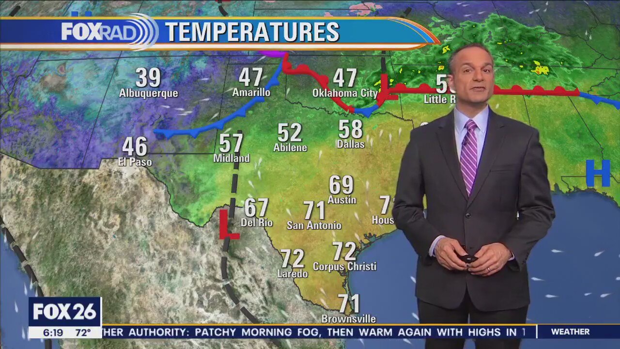
Patchy morning fog, then warm again with highs in the low-to-mid 80s
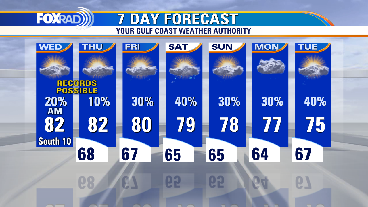
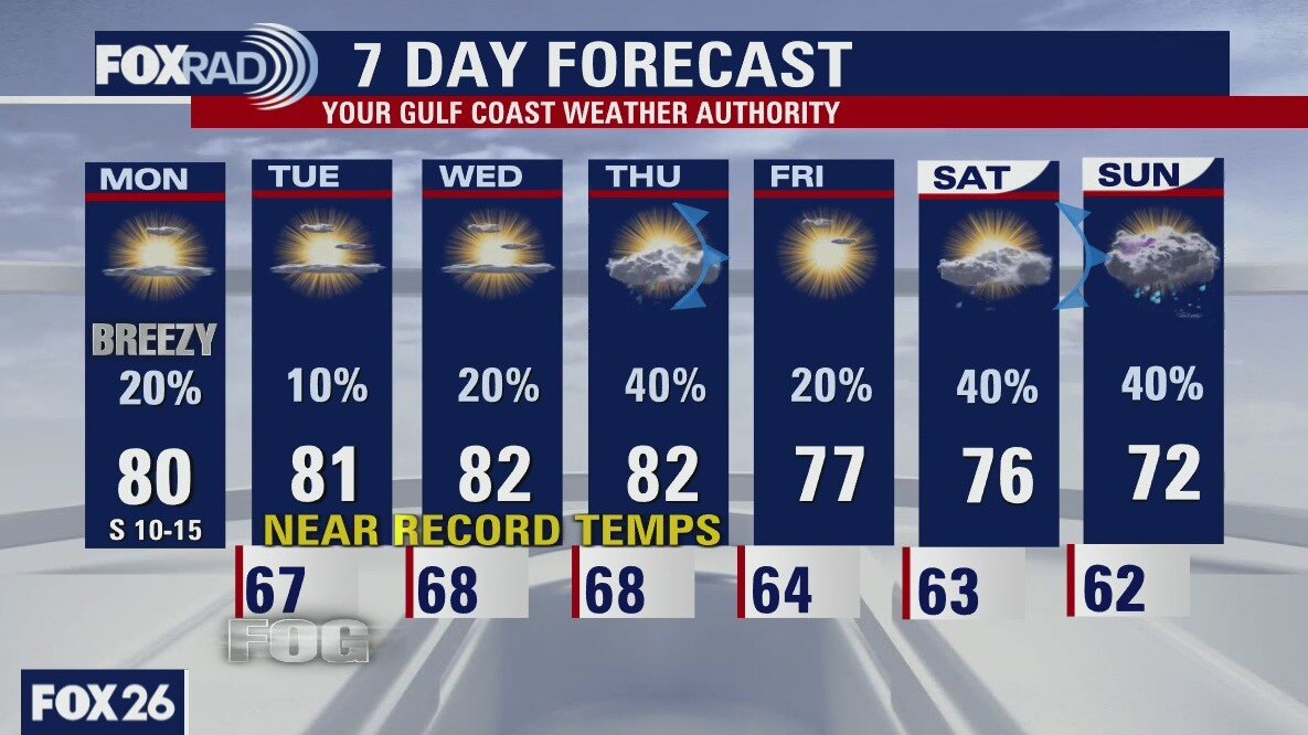
A cold front is on the way, but it's not going to arrive until the middle of next week. Until then, our unseasonably warm and humid pattern will continue, though with a better chance for showers Friday through the weekend. A cold front Tuesday or early Wednesday could bring a round of thunderstorms followed by a 20 degree drop in temperatures.
A cold front is on the way, but it's not going to arrive until the middle of next week. Until then, our unseasonably warm and humid pattern will continue, though with a better chance for showers Friday through the weekend. A cold front Tuesday or early Wednesday could bring a round of thunderstorms followed by a 20 degree drop in temperatures.
Thursday morning weather forecast
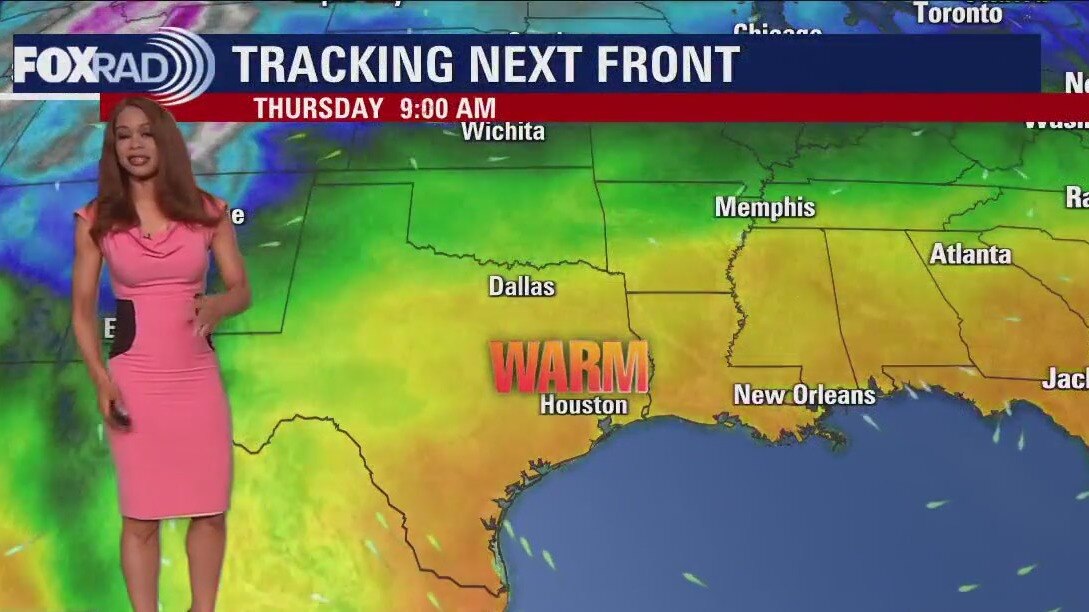
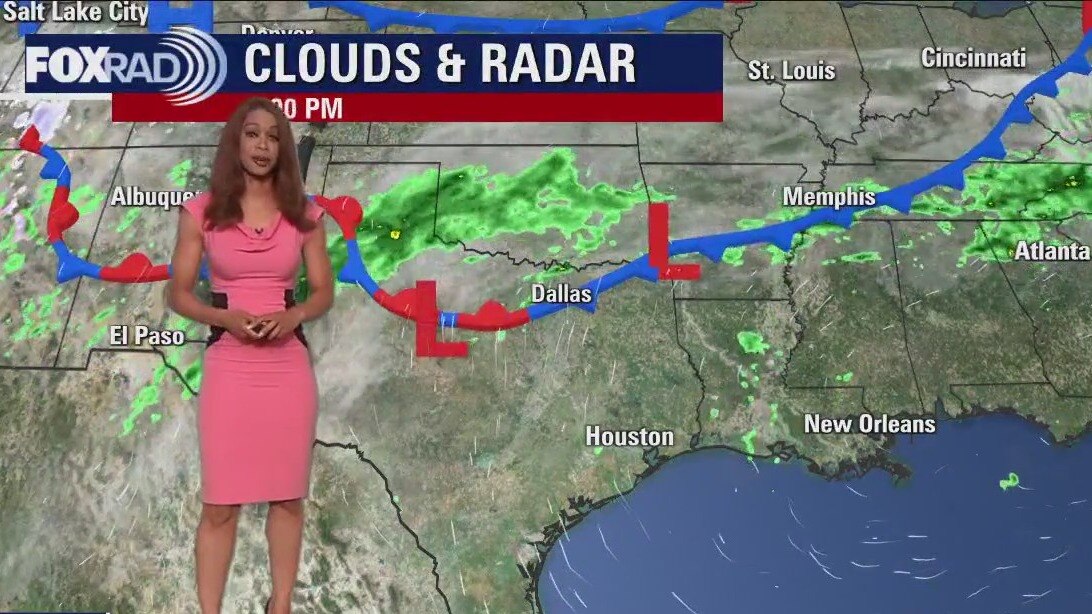
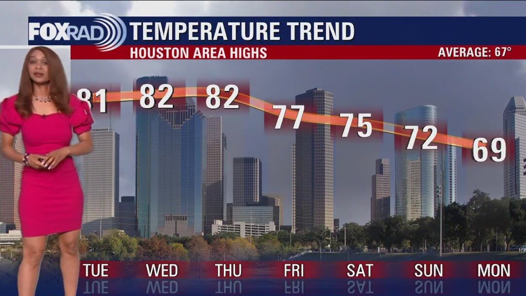
It's more of the same with our mostly cloudy, sometimes foggy and unseasonably warm spring-like weather pattern. We once again reached record high temperatures today with Houston Hobby Airport reporting a record high of 84 degrees and Galveston reporting a new record high of 80 degrees. We will be close to records once again on Thursday in the low 80s. Some patchy fog will develop again late tonight, especially near the coast that could be thick. Warm temps with a few light rain showers will stick around through early next week. A pattern shift finally appears in the forecast by the middle of next week as a stronger cold front moves through. Rain chances increase Tuesday ahead of that front with cooler air finally returning Wednesday.
It's more of the same with our mostly cloudy, sometimes foggy and unseasonably warm spring-like weather pattern. We once again reached record high temperatures today with Houston Hobby Airport reporting a record high of 84 degrees and Galveston reporting a new record high of 80 degrees. We will be close to records once again on Thursday in the low 80s. Some patchy fog will develop again late tonight, especially near the coast that could be thick. Warm temps with a few light rain showers will stick around through early next week. A pattern shift finally appears in the forecast by the middle of next week as a stronger cold front moves through. Rain chances increase Tuesday ahead of that front with cooler air finally returning Wednesday.
Wednesday evening weather forecast
It's more of the same with our mostly cloudy, sometimes foggy and unseasonably warm spring-like weather pattern. We once again reached record high temperatures today with Houston Hobby Airport reporting a record high of 84 degrees and Galveston reporting a new record high of 80 degrees. We will be close to records once again on Thursday in the low 80s. Some patchy fog will develop again late tonight, especially near the coast that could be thick. Warm temps with a few light rain showers will stick around through early next week. A pattern shift finally appears in the forecast by the middle of next week as a stronger cold front moves through. Rain chances increase Tuesday ahead of that front with cooler air finally returning Wednesday.
It's more of the same with our mostly cloudy, sometimes foggy and unseasonably warm spring-like weather pattern. We once again reached record high temperatures today with Houston Hobby Airport reporting a record high of 84 degrees and Galveston reporting a new record high of 80 degrees. We will be close to records once again on Thursday in the low 80s. Some patchy fog will develop again late tonight, especially near the coast that could be thick. Warm temps with a few light rain showers will stick around through early next week. A pattern shift finally appears in the forecast by the middle of next week as a stronger cold front moves through. Rain chances increase Tuesday ahead of that front with cooler air finally returning Wednesday.
Wednesday morning weather with Chief Meteorologist Mike Iscovitz
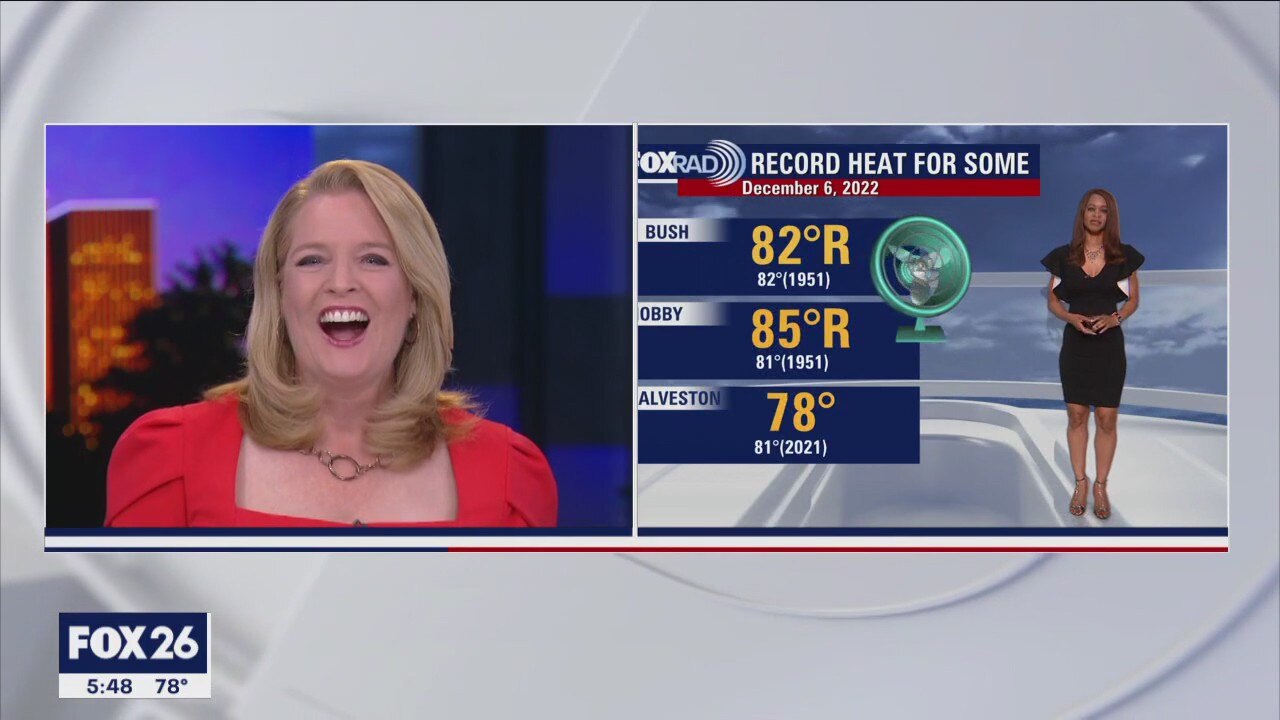
The record high of 82? was tied at Bush Airport yesterday as Hobby Airport hit 85? smashing the previous record of 81?. A warm pattern will remain on place through the weekend with daily highs in the upper 70s and low 80s - about 12-15 degrees above normal for this time of year. Morning fog and isolated showers are also likely with light rain more widespread for Friday through early next week. A brief shot of cold air is on the way for the middle of next week.
The record high of 82? was tied at Bush Airport yesterday as Hobby Airport hit 85? smashing the previous record of 81?. A warm pattern will remain on place through the weekend with daily highs in the upper 70s and low 80s - about 12-15 degrees above normal for this time of year. Morning fog and isolated showers are also likely with light rain more widespread for Friday through early next week. A brief shot of cold air is on the way for the middle of next week.
Wednesday morning weather forecast
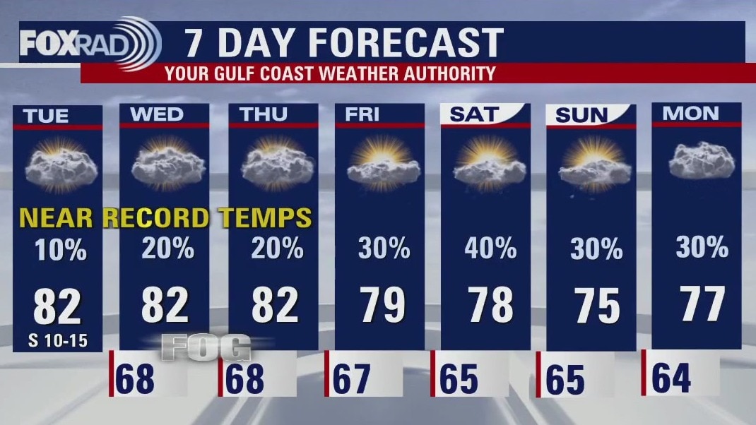
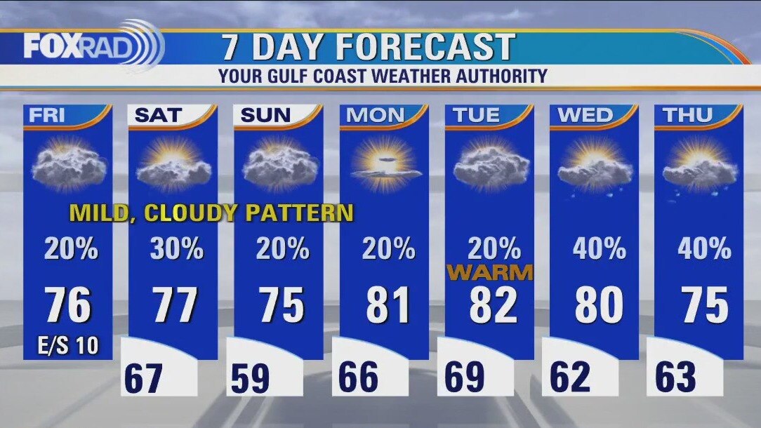
More near record heat is in store for the next few days with afternoon high temperatures climbing to the low 80s through Thursday. Even through the weekend, there won't be a big drop in temperatures. A weak cold front will try to make it in late week. But now models are hinting that the front may stall out to our north keeping it warm and humid here. So plan on more spring-like weather through at least early next week! Rain chances will improve slightly late week into next week. It looks like some noticeably cooler air might finally make it in by the middle of next week.
More near record heat is in store for the next few days with afternoon high temperatures climbing to the low 80s through Thursday. Even through the weekend, there won't be a big drop in temperatures. A weak cold front will try to make it in late week. But now models are hinting that the front may stall out to our north keeping it warm and humid here. So plan on more spring-like weather through at least early next week! Rain chances will improve slightly late week into next week. It looks like some noticeably cooler air might finally make it in by the middle of next week.
Tuesday evening weather forecast
More near record heat is in store for the next few days with afternoon high temperatures climbing to the low 80s through Thursday. Even through the weekend, there won't be a big drop in temperatures. A weak cold front will try to make it in late week. But now models are hinting that the front may stall out to our north keeping it warm and humid here. So plan on more spring-like weather through at least early next week! Rain chances will improve slightly late week into next week. It looks like some noticeably cooler air might finally make it in by the middle of next week.
More near record heat is in store for the next few days with afternoon high temperatures climbing to the low 80s through Thursday. Even through the weekend, there won't be a big drop in temperatures. A weak cold front will try to make it in late week. But now models are hinting that the front may stall out to our north keeping it warm and humid here. So plan on more spring-like weather through at least early next week! Rain chances will improve slightly late week into next week. It looks like some noticeably cooler air might finally make it in by the middle of next week.
Tuesday afternoon weather forecast with Meteorologist John Dawson
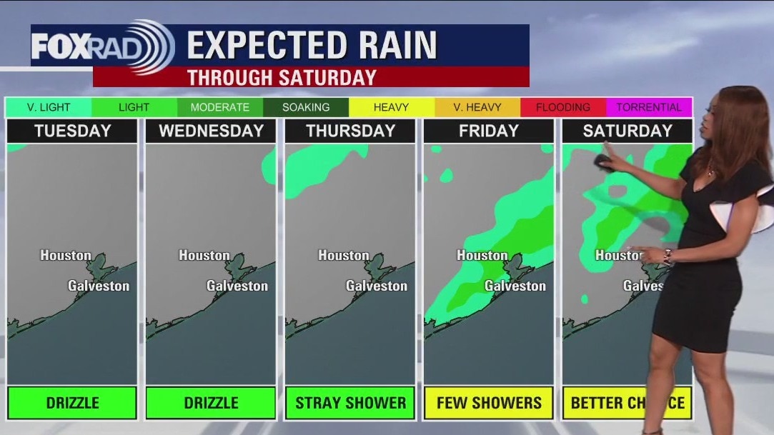
If you like spring-like weather in December, this forecast is for you. Record highs for the rest of this week are in the low 80s and our forecast highs are within a degree or two of those records through Thursday with only a slight fall after that. Other than a few light showers this week, the forecast looks relatively quiet with a better chance for light rain by this weekend.
If you like spring-like weather in December, this forecast is for you. Record highs for the rest of this week are in the low 80s and our forecast highs are within a degree or two of those records through Thursday with only a slight fall after that. Other than a few light showers this week, the forecast looks relatively quiet with a better chance for light rain by this weekend.

Tuesday morning weather with Chief Meteorologist Mike Iscovitz
If you like spring-like weather in December, this forecast is for you. Record highs for the rest of this week are in the low 80s and our forecast highs are within a degree or two of those records through Thursday with only a slight fall after that. Other than a few light showers this week, the forecast looks relatively quiet with a better chance for light rain by this weekend.
If you like spring-like weather in December, this forecast is for you. Record highs for the rest of this week are in the low 80s and our forecast highs are within a degree or two of those records through Thursday with only a slight fall after that. Other than a few light showers this week, the forecast looks relatively quiet with a better chance for light rain by this weekend.
Tuesday morning weather forecast
Look for more fog to develop tonight and hang around early Tuesday, especially along the coast. In fact, fog will be a nuisance for some off and on for the next few days. The other big story will be the December heat. Near record high temperatures are in store for the Houston area through Thursday. Look for highs to soar to the low 80s with just an isolated shower possible. Weak cold front arrives late Thursday which will bring a slightly higher shot for rain. Best chance for rain over the next week comes Sunday with a stronger front and a slighter bigger drop in temps.
Look for more fog to develop tonight and hang around early Tuesday, especially along the coast. In fact, fog will be a nuisance for some off and on for the next few days. The other big story will be the December heat. Near record high temperatures are in store for the Houston area through Thursday. Look for highs to soar to the low 80s with just an isolated shower possible. Weak cold front arrives late Thursday which will bring a slightly higher shot for rain. Best chance for rain over the next week comes Sunday with a stronger front and a slighter bigger drop in temps.
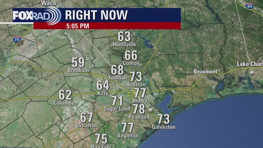
Monday evening weather forecast
Look for more fog to develop tonight and hang around early Tuesday, especially along the coast. In fact, fog will be a nuisance for some off and on for the next few days. The other big story will be the December heat. Near record high temperatures are in store for the Houston area through Thursday. Look for highs to soar to the low 80s with just an isolated shower possible. Weak cold front arrives late Thursday which will bring a slightly higher shot for rain. Best chance for rain over the next week comes Sunday with a stronger front and a slighter bigger drop in temps.
Look for more fog to develop tonight and hang around early Tuesday, especially along the coast. In fact, fog will be a nuisance for some off and on for the next few days. The other big story will be the December heat. Near record high temperatures are in store for the Houston area through Thursday. Look for highs to soar to the low 80s with just an isolated shower possible. Weak cold front arrives late Thursday which will bring a slightly higher shot for rain. Best chance for rain over the next week comes Sunday with a stronger front and a slighter bigger drop in temps.
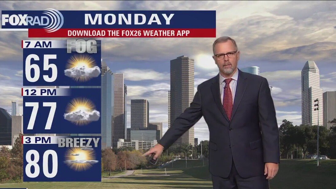
Monday afternoon weather forecast with Meteorologist John Dawson
We'll flirt with records through Thursday afternoon, with isolated rain showers. A weak, trailing cold front Thursday looks to bring a slightly better opportunity for rain and take the edge off the warmth and humidity. A stronger front is still on track to arrive over the weekend with a more promising cool down to follow. Until then, be on the look out for fog during the early morning hours.
We'll flirt with records through Thursday afternoon, with isolated rain showers. A weak, trailing cold front Thursday looks to bring a slightly better opportunity for rain and take the edge off the warmth and humidity. A stronger front is still on track to arrive over the weekend with a more promising cool down to follow. Until then, be on the look out for fog during the early morning hours.

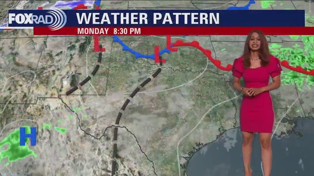
Monday morning weather forecast with Meteorologist Lena Maria Arango
We'll flirt with records through Thursday afternoon, with isolated rain showers. A weak, trailing cold front Thursday looks to bring a slightly better opportunity for rain and take the edge off the warmth and humidity. A stronger front is still on track to arrive over the weekend with a more promising cool down to follow. Until then, be on the look out for fog during the early morning hours.
We'll flirt with records through Thursday afternoon, with isolated rain showers. A weak, trailing cold front Thursday looks to bring a slightly better opportunity for rain and take the edge off the warmth and humidity. A stronger front is still on track to arrive over the weekend with a more promising cool down to follow. Until then, be on the look out for fog during the early morning hours.
Saturday evening/Monday morning weather forecast
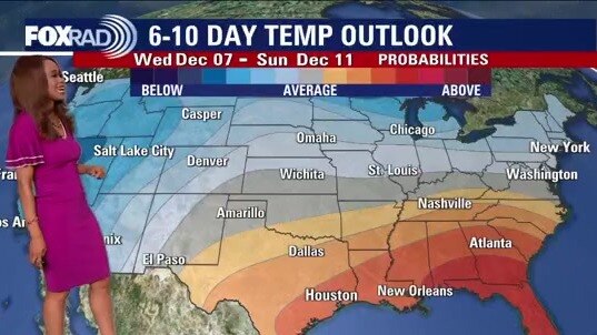
Muggy and humid returns to Houston on Monday. There will also be at least a slight chance of showers each day this week until another weak cold front tries to make it all the way through Southeast Texas. Rain chances increase as the front approaches and temperatures drop slightly. A stronger front at the beginning of next week should bring our temperatures back down to seasonable numbers for December.
Muggy and humid returns to Houston on Monday. There will also be at least a slight chance of showers each day this week until another weak cold front tries to make it all the way through Southeast Texas. Rain chances increase as the front approaches and temperatures drop slightly. A stronger front at the beginning of next week should bring our temperatures back down to seasonable numbers for December.
Cloudy, humid with temps in the 70s Saturday evening
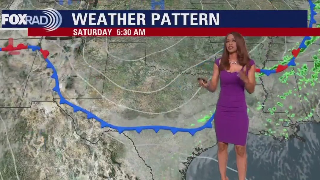
A weak cold front barely made it to the coast on Saturday allowing a slightly cooler and drier air mass to move into Southeast Texas. The boundary will lift back north as a warm front on Sunday and set up Houston for a warm week. Muggy mornings and warm afternoons until another weak front arrives towards the end of the week.
A weak cold front barely made it to the coast on Saturday allowing a slightly cooler and drier air mass to move into Southeast Texas. The boundary will lift back north as a warm front on Sunday and set up Houston for a warm week. Muggy mornings and warm afternoons until another weak front arrives towards the end of the week.
Saturday morning weather forecast
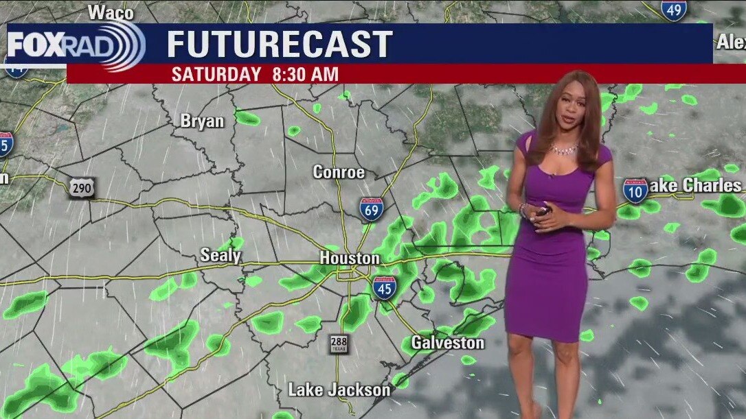
Southerly flow has ushered in much warmer air as we slide into the weekend. We stay mild tonight in the 60s with some drizzle and areas of thick fog possible, especially along the coast. Saturday's weather will feature some patchy fog and a weak cold front that will bring in a few light rain showers through the afternoon with most of it ending by Saturday evening. Temps stay mild in the 70s Saturday and near 70 Sunday. Look for even warmer temps in the 80s early next week with a few more small chances for rain.
Southerly flow has ushered in much warmer air as we slide into the weekend. We stay mild tonight in the 60s with some drizzle and areas of thick fog possible, especially along the coast. Saturday's weather will feature some patchy fog and a weak cold front that will bring in a few light rain showers through the afternoon with most of it ending by Saturday evening. Temps stay mild in the 70s Saturday and near 70 Sunday. Look for even warmer temps in the 80s early next week with a few more small chances for rain.
Friday evening weather forecast
Southerly flow has ushered in much warmer air as we slide into the weekend. We stay mild tonight in the 60s with some drizzle and areas of thick fog possible, especially along the coast. Saturday's weather will feature some patchy fog and a weak cold front that will bring in a few light rain showers through the afternoon with most of it ending by Saturday evening. Temps stay mild in the 70s Saturday and near 70 Sunday. Look for even warmer temps in the 80s early next week with a few more small chances for rain.
Southerly flow has ushered in much warmer air as we slide into the weekend. We stay mild tonight in the 60s with some drizzle and areas of thick fog possible, especially along the coast. Saturday's weather will feature some patchy fog and a weak cold front that will bring in a few light rain showers through the afternoon with most of it ending by Saturday evening. Temps stay mild in the 70s Saturday and near 70 Sunday. Look for even warmer temps in the 80s early next week with a few more small chances for rain.
Cloudy, light chance of showers Friday afternoon
As a warm front lifts north today, a cloudy, mild, and drippy pattern will set in for the start of the weekend. Weak cold front cruises through Saturday, but it won't bring many noticeable changes aside from a slightly increased chance of showers. We then get downright warm at the start of next week, before the next front maybe brings some changes mid-end of the week. Look out for patchy fog which will reduce visibilities in the mornings, and light showers which likely won't be umbrella-worthy but more along the lines of nuisance rain.
As a warm front lifts north today, a cloudy, mild, and drippy pattern will set in for the start of the weekend. Weak cold front cruises through Saturday, but it won't bring many noticeable changes aside from a slightly increased chance of showers. We then get downright warm at the start of next week, before the next front maybe brings some changes mid-end of the week. Look out for patchy fog which will reduce visibilities in the mornings, and light showers which likely won't be umbrella-worthy but more along the lines of nuisance rain.
A few showers Friday with highs in the mid 70s
Warmer temperatures are on the return to Southeast Texas. You will also notice the increasing humidity on Friday with some areas of drizzle and light rain. Look for a few more showers on Saturday and Sunday with more clouds than sun. Warm and humid pattern sticks around for much of next week with another front trying to make it to Houston towards the end of the week.
Warmer temperatures are on the return to Southeast Texas. You will also notice the increasing humidity on Friday with some areas of drizzle and light rain. Look for a few more showers on Saturday and Sunday with more clouds than sun. Warm and humid pattern sticks around for much of next week with another front trying to make it to Houston towards the end of the week.
Friday morning weather forecast
It has been a chilly start to December with 30s this morning and high temperature of only 60 at Bush Intercontinental Airport. Wind shifts to the south Friday ushering in more moisture and warm temps. Look for some areas of drizzle Friday with more clouds than sun. A few more showers are possible Saturday and Sunday but there will definitely be more dry time than wet weather. Warm and humid pattern sticks around for much of next week with a few more shots at rain. Another front will try to make it in by next Wednesday and Thursday.
It has been a chilly start to December with 30s this morning and high temperature of only 60 at Bush Intercontinental Airport. Wind shifts to the south Friday ushering in more moisture and warm temps. Look for some areas of drizzle Friday with more clouds than sun. A few more showers are possible Saturday and Sunday but there will definitely be more dry time than wet weather. Warm and humid pattern sticks around for much of next week with a few more shots at rain. Another front will try to make it in by next Wednesday and Thursday.
Thursday evening weather forecast
It has been a chilly start to December with 30s this morning and high temperature of only 60 at Bush Intercontinental Airport. Wind shifts to the south Friday ushering in more moisture and warm temps. Look for some areas of drizzle Friday with more clouds than sun. A few more showers are possible Saturday and Sunday but there will definitely be more dry time than wet weather. Warm and humid pattern sticks around for much of next week with a few more shots at rain. Another front will try to make it in by next Wednesday and Thursday.
It has been a chilly start to December with 30s this morning and high temperature of only 60 at Bush Intercontinental Airport. Wind shifts to the south Friday ushering in more moisture and warm temps. Look for some areas of drizzle Friday with more clouds than sun. A few more showers are possible Saturday and Sunday but there will definitely be more dry time than wet weather. Warm and humid pattern sticks around for much of next week with a few more shots at rain. Another front will try to make it in by next Wednesday and Thursday.