

WEATHER ALERT: Strong, severe storms expected on Tuesday
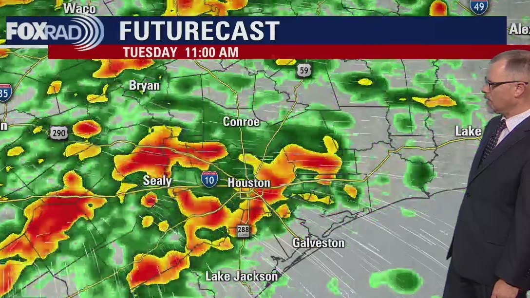
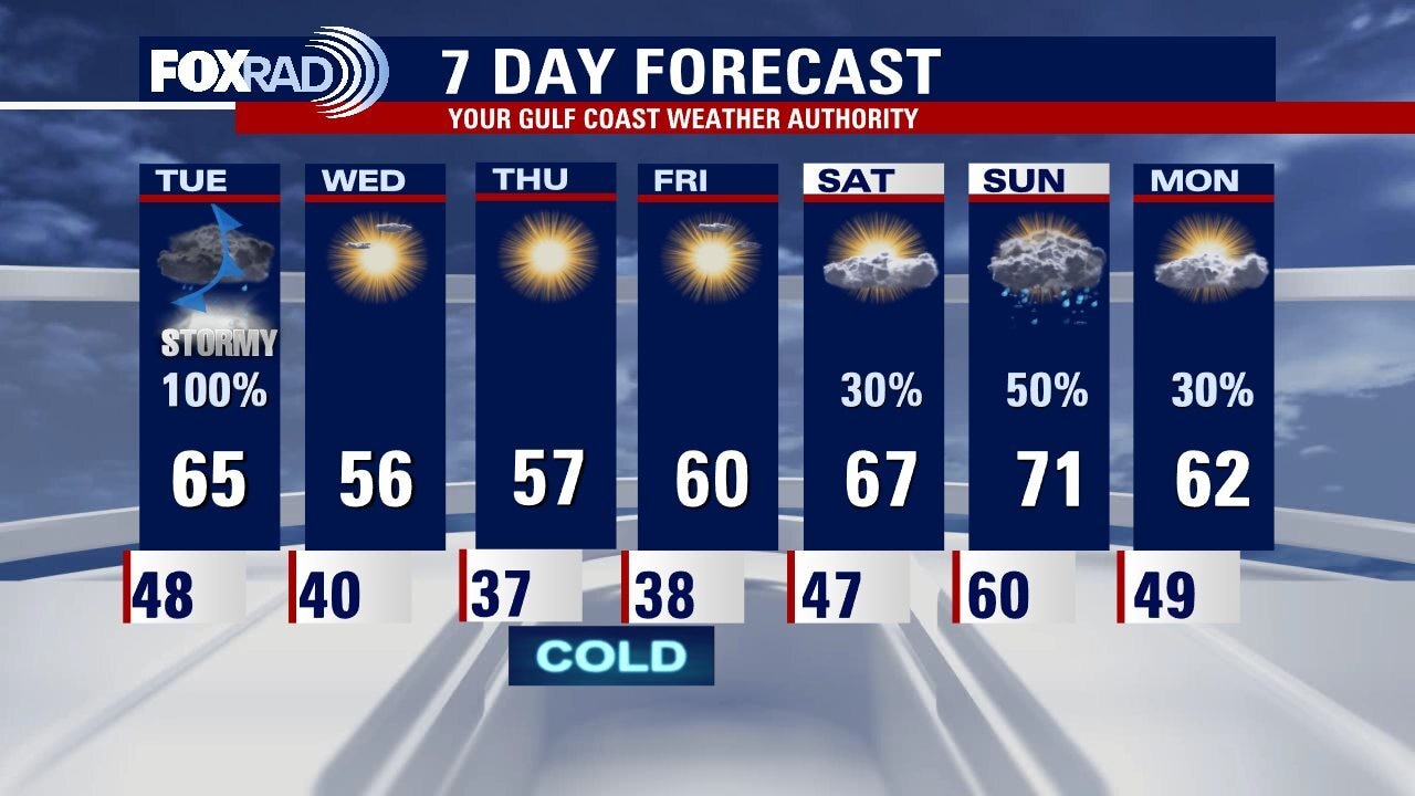
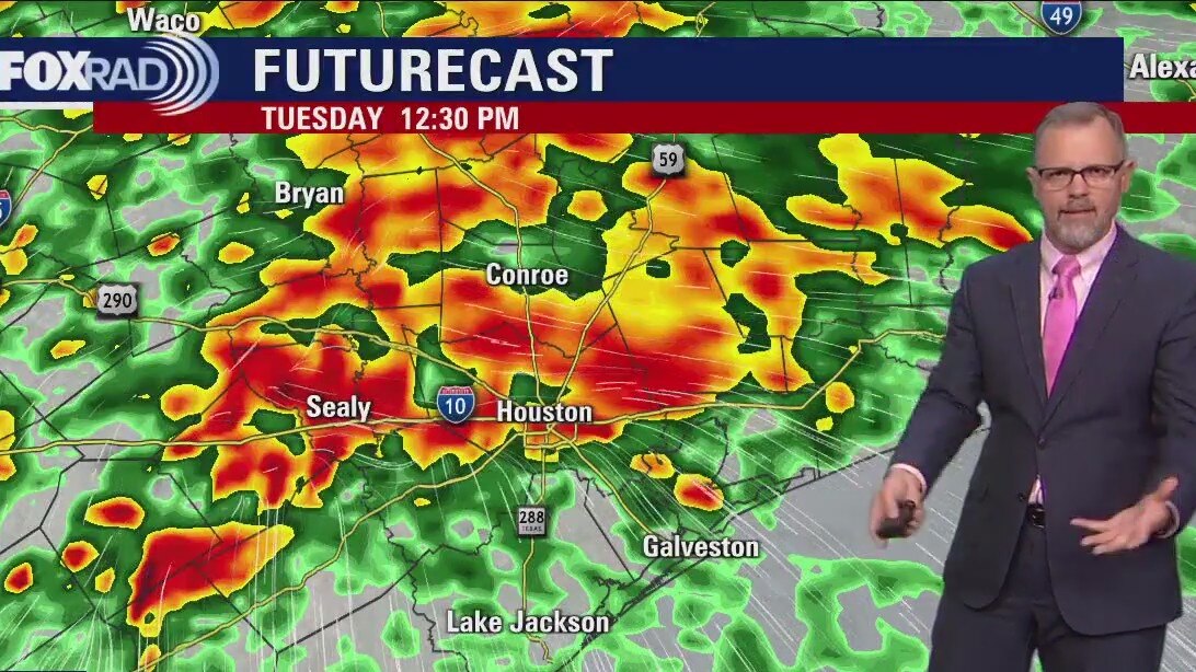
Stormy weather across Southeast Texas on Tuesday as a cold front moves through the area. Look for the strongest storms between 10am to 4pm. Damaging winds is the primary threat with hail also possible. Closer to the coast, a chance for an isolated tornado will also be possible. After the front clears, plan for pleasant, cool weather for the rest of the week.
Stormy weather across Southeast Texas on Tuesday as a cold front moves through the area. Look for the strongest storms between 10am to 4pm. Damaging winds is the primary threat with hail also possible. Closer to the coast, a chance for an isolated tornado will also be possible. After the front clears, plan for pleasant, cool weather for the rest of the week.
Monday evening weather forecast with Meteorologist John Dawson
Stormy weather across Southeast Texas on Tuesday as a cold front moves through the area. Look for the strongest storms between 10am to 4pm. Damaging winds is the primary threat with hail also possible. Closer to the coast, a chance for an isolated tornado will also be possible. After the front clears, plan for pleasant, cool weather for the rest of the week.
Stormy weather across Southeast Texas on Tuesday as a cold front moves through the area. Look for the strongest storms between 10am to 4pm. Damaging winds is the primary threat with hail also possible. Closer to the coast, a chance for an isolated tornado will also be possible. After the front clears, plan for pleasant, cool weather for the rest of the week.

Monday afternoon weather forecast with Meteorologist Remeisha Shade
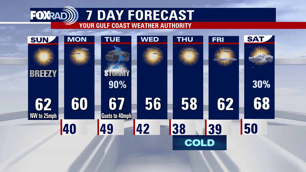
Today is the calm before the storm as a powerful system is expected to roll across SE Texas Tuesday. Stay alert tomorrow and make sure you have the FOX 26 weather app downloaded on your phone or tablet. We stay cool and dry today with high temperatures near 60. Look for increasing clouds and wind tonight with showers building on Tuesday morning. Late morning through Tuesday afternoon will be the worst of the weather with very heavy rain & strong to severe storms. Some storms could be severe with damaging winds, a few tornadoes & heavy rain that could lead to flooding. Rain should be winding down by Tuesday evening with cooler/drier air building in for Wednesday and Thursday. The next round of rain should return by this weekend.
Today is the calm before the storm as a powerful system is expected to roll across SE Texas Tuesday. Stay alert tomorrow and make sure you have the FOX 26 weather app downloaded on your phone or tablet. We stay cool and dry today with high temperatures near 60. Look for increasing clouds and wind tonight with showers building on Tuesday morning. Late morning through Tuesday afternoon will be the worst of the weather with very heavy rain & strong to severe storms. Some storms could be severe with damaging winds, a few tornadoes & heavy rain that could lead to flooding. Rain should be winding down by Tuesday evening with cooler/drier air building in for Wednesday and Thursday. The next round of rain should return by this weekend.
Houston weather: Cold Monday morning, then mostly sunny, cool and dry
Get ready for a rocky Tuesday! Today will be clear and chilly with only high clouds moving in late. Everything goes downhill late tomorrow morning with a strong area of low pressure moving right overhead. Heavy rain up to 4" along with lots of lightning and even potential for damaging winds. That system moves out by tomorrow evening and ushers in several days of chilly, sunny days.
Get ready for a rocky Tuesday! Today will be clear and chilly with only high clouds moving in late. Everything goes downhill late tomorrow morning with a strong area of low pressure moving right overhead. Heavy rain up to 4" along with lots of lightning and even potential for damaging winds. That system moves out by tomorrow evening and ushers in several days of chilly, sunny days.
Houston weather: Sunday evening/Monday morning forecast, storms expected Tuesday
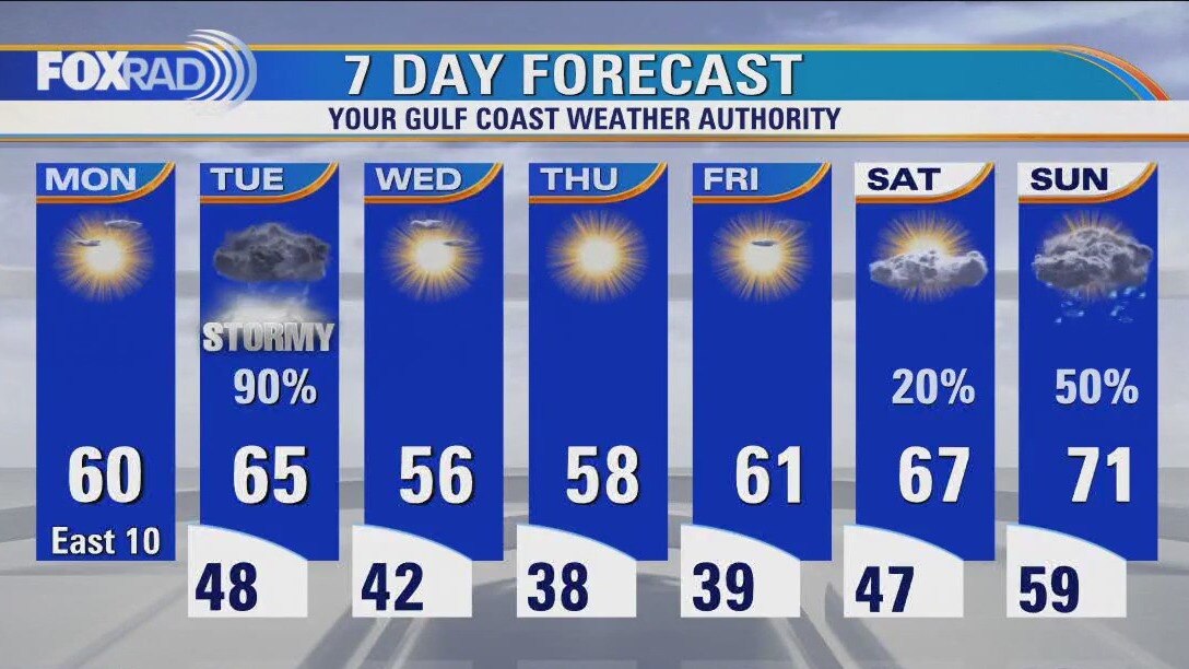
Monday looks pleasant with clear and cool conditions across Houston. The focus this week will be on Tuesday with strong to severe storms expected across Southeast Texas. Heavy downpours could also create some flooding problems as well. More cool and dry weather to end the work week with rain back in the forecast for the weekend.
Monday looks pleasant with clear and cool conditions across Houston. The focus this week will be on Tuesday with strong to severe storms expected across Southeast Texas. Heavy downpours could also create some flooding problems as well. More cool and dry weather to end the work week with rain back in the forecast for the weekend.
Sunday weather forecast with Meteorologist Lena Maria Arango
Aside from the breeze, today will be a pleasant January day with sunshine continuing tomorrow. Tuesday is really our only problematic day of the week, with strong to severe storm potential and locally heavy rainfall likely. Look for a few cold starts toward the end of the week post-front, with inland locations likely closer to freezing. Southerly winds take over again by the weekend, increasing temps, humidity and rain chances.
Aside from the breeze, today will be a pleasant January day with sunshine continuing tomorrow. Tuesday is really our only problematic day of the week, with strong to severe storm potential and locally heavy rainfall likely. Look for a few cold starts toward the end of the week post-front, with inland locations likely closer to freezing. Southerly winds take over again by the weekend, increasing temps, humidity and rain chances.
Houston weather: Cool Saturday evening in the 50s with light rain
Rain clears out of southeast Texas on Saturday night and mostly sunny skies will provide more opportunities for outdoor activities during the second half of the weekend. Another cold front on Tuesday will bring strong to severe storms across Houston. Overall the pattern for January changes from a very warm start to a much cooler end.
Rain clears out of southeast Texas on Saturday night and mostly sunny skies will provide more opportunities for outdoor activities during the second half of the weekend. Another cold front on Tuesday will bring strong to severe storms across Houston. Overall the pattern for January changes from a very warm start to a much cooler end.


Houston Weather: Rain on the radar for Saturday
This weekend will end much better than it's starting, with a front pulling in drier air for Sunday. Sunshine and quiet weather lingers through Monday, but Tuesday strong to severe storm potential and heavy rainfall possibilities return. Chilly air will follow, with daytime highs stuck mostly in the 50s and a few overnight lows in the 30s-40s to close out the week
This weekend will end much better than it's starting, with a front pulling in drier air for Sunday. Sunshine and quiet weather lingers through Monday, but Tuesday strong to severe storm potential and heavy rainfall possibilities return. Chilly air will follow, with daytime highs stuck mostly in the 50s and a few overnight lows in the 30s-40s to close out the week


Houston Weather: Saturday expected to be more soggy than Friday
We're in for a couple of dreary days, with cloudy and cool conditions and some rain in the mix. Saturday will be the soggier of the two, including a few isolated storms and downpours. Sunday is your best bet to get outside, temperatures will warm slightly with full sunshine just plan for gusty winds. And much of the next week features quiet, seasonably cool days aside from Tuesday which will be another day to watch from a heavy rain and storm standpoint.
We're in for a couple of dreary days, with cloudy and cool conditions and some rain in the mix. Saturday will be the soggier of the two, including a few isolated storms and downpours. Sunday is your best bet to get outside, temperatures will warm slightly with full sunshine just plan for gusty winds. And much of the next week features quiet, seasonably cool days aside from Tuesday which will be another day to watch from a heavy rain and storm standpoint.
Houston Weather: Saturday expected to be soggier than Friday
We're in for a couple of dreary days, with cloudy and cool conditions and some rain in the mix. Saturday will be the soggier of the two, including a few isolated storms and downpours. Sunday is your best bet to get outside, temperatures will warm slightly with full sunshine just plan for gusty winds. And much of the next week features quiet, seasonably cool days aside from Tuesday which will be another day to watch from a heavy rain and storm standpoint.
We're in for a couple of dreary days, with cloudy and cool conditions and some rain in the mix. Saturday will be the soggier of the two, including a few isolated storms and downpours. Sunday is your best bet to get outside, temperatures will warm slightly with full sunshine just plan for gusty winds. And much of the next week features quiet, seasonably cool days aside from Tuesday which will be another day to watch from a heavy rain and storm standpoint.


Houston Weather: Rainy Saturday expected, plan accordingly
Clouds are building in, so today looks overcast which should keep temperatures in the 50s and low 60s all day. Plan for a wash-out on Saturday with scattered showers inland and a few heavier downpours for coastal counties along with highs near 60. Sunday and Monday look great, but storms return on Tuesday. Notice our lows and highs remain on the cool side, though not frigid, for the next week.
Clouds are building in, so today looks overcast which should keep temperatures in the 50s and low 60s all day. Plan for a wash-out on Saturday with scattered showers inland and a few heavier downpours for coastal counties along with highs near 60. Sunday and Monday look great, but storms return on Tuesday. Notice our lows and highs remain on the cool side, though not frigid, for the next week.

Houston Weather: Rainy Saturday ahead, plan accordingly
After three weeks of unseasonably warm weather, a pattern change begins today. Clouds are building in, so today looks overcast which should keep temperatures in the 50s and low 60s all day. Plan for a wash-out on Saturday with scattered showers inland and a few heavier downpours for coastal counties along with highs near 60. Sunday and Monday look great, but storms return on Tuesday. Notice our lows and highs remain on the cool side, though not frigid, for the next week.
After three weeks of unseasonably warm weather, a pattern change begins today. Clouds are building in, so today looks overcast which should keep temperatures in the 50s and low 60s all day. Plan for a wash-out on Saturday with scattered showers inland and a few heavier downpours for coastal counties along with highs near 60. Sunday and Monday look great, but storms return on Tuesday. Notice our lows and highs remain on the cool side, though not frigid, for the next week.
Sunny, pleasant temperatures in the low 70s
Look for some clouds increasing tonight with cool and dry conditions. Grab the jackets tonight as temperatures tumble to the 40s and 50s. Actually our weather pattern will shift for the next week or so keeping temperatures near or just below average instead of near record heat. Our normal high temperature for this time of the year is 64 degrees. There will also be a few rounds of rain to deal with. The first will come on Saturday with widespread rain likely associated with a coastal low. The next big shot for rain and possibly a few strong storms will be Tuesday.
Look for some clouds increasing tonight with cool and dry conditions. Grab the jackets tonight as temperatures tumble to the 40s and 50s. Actually our weather pattern will shift for the next week or so keeping temperatures near or just below average instead of near record heat. Our normal high temperature for this time of the year is 64 degrees. There will also be a few rounds of rain to deal with. The first will come on Saturday with widespread rain likely associated with a coastal low. The next big shot for rain and possibly a few strong storms will be Tuesday.
Houston weather: Clear and chilly Thursday morning, then sunny and dry
If you've had enough of this unseasonably warm January, a pattern change has begun and we'll remain near or below normal temperatures. Today looks great, tomorrow looks cloudy and chilly, then watch for a rainy Saturday. Another round of rain should arrive on Tuesday next week.
If you've had enough of this unseasonably warm January, a pattern change has begun and we'll remain near or below normal temperatures. Today looks great, tomorrow looks cloudy and chilly, then watch for a rainy Saturday. Another round of rain should arrive on Tuesday next week.
Wednesday night leading into Thursday morning weather forecast
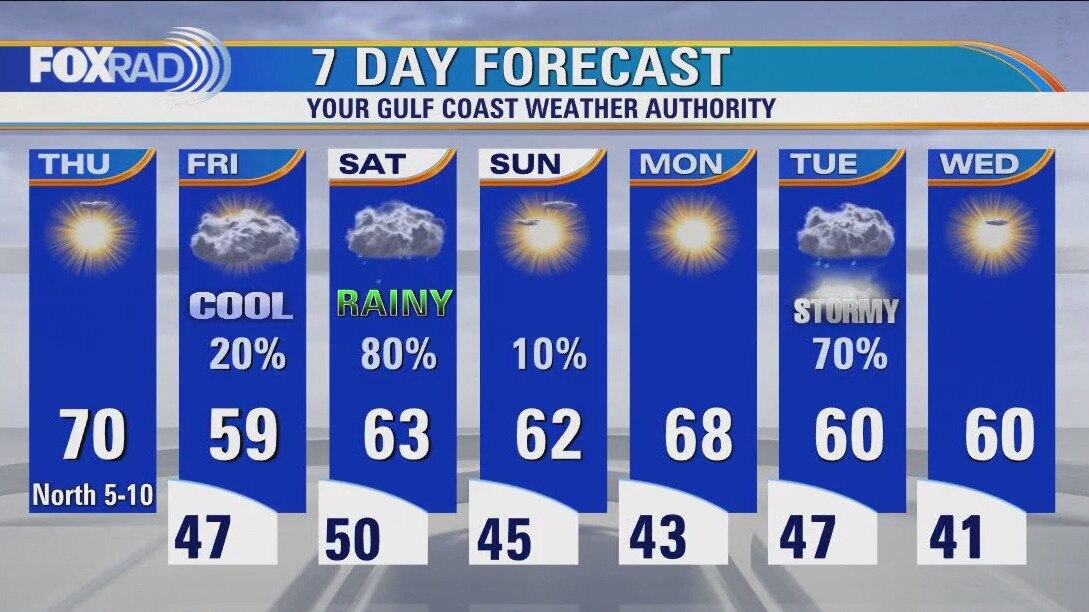
A cold front has moved through SE Texas ending our risk for severe storms. Cooler and drier air will build in behind this front which means quiet weather for your plans tonight. Grab a jacket though as temperatures tonight dip to the 40s for most areas. It will be a bright and pleasant Thursday with highs in the 60s and lots of sunshine. Look for clouds to increase Friday and widespread rain to return Saturday. Temperatures will stay seasonable through the weekend.
A cold front has moved through SE Texas ending our risk for severe storms. Cooler and drier air will build in behind this front which means quiet weather for your plans tonight. Grab a jacket though as temperatures tonight dip to the 40s for most areas. It will be a bright and pleasant Thursday with highs in the 60s and lots of sunshine. Look for clouds to increase Friday and widespread rain to return Saturday. Temperatures will stay seasonable through the weekend.

Wednesday evening weather forecast with Meteorologist Remeisha Shade
A cold front has moved through SE Texas ending our risk for severe storms. Cooler and drier air will build in behind this front which means quiet weather for your plans tonight. Grab a jacket though as temperatures tonight dip to the 40s for most areas. It will be a bright and pleasant Thursday with highs in the 60s and lots of sunshine. Look for clouds to increase Friday and widespread rain to return Saturday. Temperatures will stay seasonable through the weekend.
A cold front has moved through SE Texas ending our risk for severe storms. Cooler and drier air will build in behind this front which means quiet weather for your plans tonight. Grab a jacket though as temperatures tonight dip to the 40s for most areas. It will be a bright and pleasant Thursday with highs in the 60s and lots of sunshine. Look for clouds to increase Friday and widespread rain to return Saturday. Temperatures will stay seasonable through the weekend.
Houston weather: Cold front moves through on Wednesday
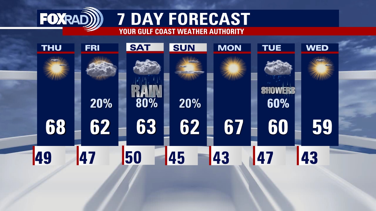
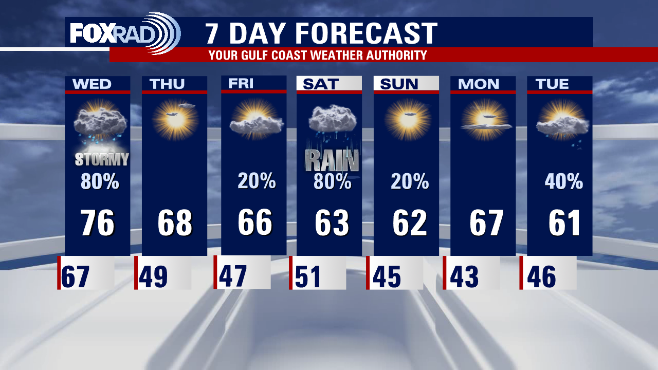
A cold front will move through between 10 a.m. and 3 p.m. today and will likely bring a round of storms, a few of which could be heavy and could produce high winds. Beginning this evening, much drier air moves in and we'll enjoy lows in the 40s with highs in the 60s for Thursday and Friday. Watch for another round of rain on Saturday.
A cold front will move through between 10 a.m. and 3 p.m. today and will likely bring a round of storms, a few of which could be heavy and could produce high winds. Beginning this evening, much drier air moves in and we'll enjoy lows in the 40s with highs in the 60s for Thursday and Friday. Watch for another round of rain on Saturday.
Wednesday morning Houston-area weather forecast
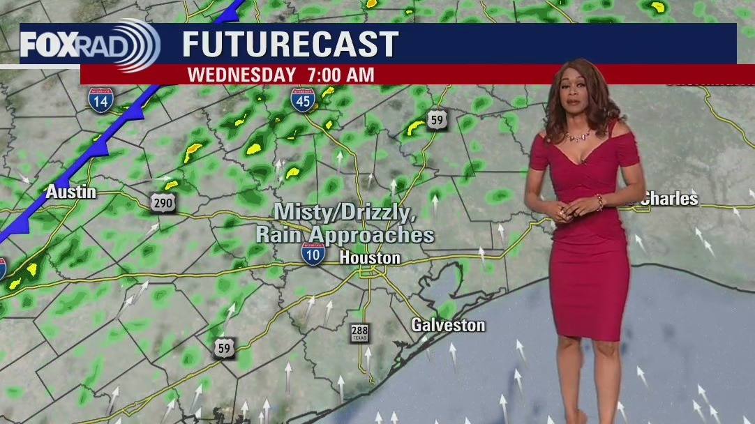
It was another record setting day across parts of SE Texas with a new record high temperature set at Houston Hobby Airport of 81 degrees. Bush Intercontinental Airport tied the record high for today making it up to 80 degrees. Galveston remained foggy much of the day so no record high was reached there. Look for some patchy coastal fog overnight with mild temperatures in the 60s. Cold front is set to bring a round of showers and storms by mid-late Wednesday morning through about 3-4 pm Wednesday afternoon. There's a low chance a few storms could be strong to severe with an isolated damaging wind gust over 50 mph being the main threat. Cooler and drier air builds in Wednesday evening and sticks around for Thursday. Next big round of rain approaches late Friday and moves in Saturday which may impact some of your weekend outdoor plans.
It was another record setting day across parts of SE Texas with a new record high temperature set at Houston Hobby Airport of 81 degrees. Bush Intercontinental Airport tied the record high for today making it up to 80 degrees. Galveston remained foggy much of the day so no record high was reached there. Look for some patchy coastal fog overnight with mild temperatures in the 60s. Cold front is set to bring a round of showers and storms by mid-late Wednesday morning through about 3-4 pm Wednesday afternoon. There's a low chance a few storms could be strong to severe with an isolated damaging wind gust over 50 mph being the main threat. Cooler and drier air builds in Wednesday evening and sticks around for Thursday. Next big round of rain approaches late Friday and moves in Saturday which may impact some of your weekend outdoor plans.
Tuesday evening weather forecast with Meteorologist Remeisha Shade
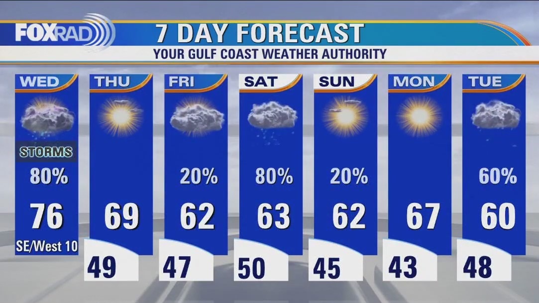
It was another record-setting day across parts of SE Texas with a new record high temperature set at Houston Hobby Airport of 81 degrees. Bush Intercontinental Airport tied the record high for today making it up to 80 degrees. Galveston remained foggy much of the day so no record high was reached there. Look for some patchy coastal fog overnight with mild temperatures in the 60s. A cold front is set to bring a round of showers and storms by mid-late Wednesday morning through about 3-4 pm Wednesday afternoon. There's a low chance a few storms could be strong to severe with an isolated damaging wind gust over 50 mph being the main threat. Cooler and drier air builds in Wednesday evening and sticks around for Thursday. Next big round of rain approaches late Friday and moves in Saturday which may impact some of your weekend outdoor plans.
It was another record-setting day across parts of SE Texas with a new record high temperature set at Houston Hobby Airport of 81 degrees. Bush Intercontinental Airport tied the record high for today making it up to 80 degrees. Galveston remained foggy much of the day so no record high was reached there. Look for some patchy coastal fog overnight with mild temperatures in the 60s. A cold front is set to bring a round of showers and storms by mid-late Wednesday morning through about 3-4 pm Wednesday afternoon. There's a low chance a few storms could be strong to severe with an isolated damaging wind gust over 50 mph being the main threat. Cooler and drier air builds in Wednesday evening and sticks around for Thursday. Next big round of rain approaches late Friday and moves in Saturday which may impact some of your weekend outdoor plans.