


FOX 26 Houston Weather Forecast
A weak front has moved into Houston and set us up for a very pleasant weekend. Look for cool mornings and comfortable afternoons with dry air moving in behind the front. Skies remain clear for Go Texan Day and Saturday/Sunday as well. Things will warm up quickly next week but we should keep rain mostly out of the forecast for the start of the Houston Rodeo.
A weak front has moved into Houston and set us up for a very pleasant weekend. Look for cool mornings and comfortable afternoons with dry air moving in behind the front. Skies remain clear for Go Texan Day and Saturday/Sunday as well. Things will warm up quickly next week but we should keep rain mostly out of the forecast for the start of the Houston Rodeo.


FOX 26 Houston Weather Forecast
A weak front has moved into Houston is set us up for a very pleasant weekend. Look for cool mornings and comfortable afternoons with dry air moving in behind the front. Skies remain clear for Go Texan Day and Saturday/Sunday as well. Things will warm up quickly next week but we should keep rain mostly out of the forecast for the start of the Houston Rodeo.
A weak front has moved into Houston is set us up for a very pleasant weekend. Look for cool mornings and comfortable afternoons with dry air moving in behind the front. Skies remain clear for Go Texan Day and Saturday/Sunday as well. Things will warm up quickly next week but we should keep rain mostly out of the forecast for the start of the Houston Rodeo.


FOX26 Houston Weather Forecast
Spring-like weather is expected across Houston. Forecast highs will be in the upper-70s to near 80 degrees. A front will sweep through the region tonight. This front won't drop temperatures too much. Overnight lows tonight will dip into the 50s. Skies remain clear for Go Texan Day and the weather is looking great for the weekend. Rodeo Houston officially begins on Tuesday with warm days ahead. There is a slight chance for showers by the middle next week.
Spring-like weather is expected across Houston. Forecast highs will be in the upper-70s to near 80 degrees. A front will sweep through the region tonight. This front won't drop temperatures too much. Overnight lows tonight will dip into the 50s. Skies remain clear for Go Texan Day and the weather is looking great for the weekend. Rodeo Houston officially begins on Tuesday with warm days ahead. There is a slight chance for showers by the middle next week.


FOX 26 Houston Weather Forecast
Spring-like weather is expected across Houston. Forecast highs will be in the upper-70s to near 80 degrees. A front will sweep through the region tonight. This front won't bring rain and won't drop temperatures too much. Overnight lows tonight will dip into the 50s. Skies remain clear for Go Texan Day and the weather is looking great for the weekend. Rodeo Houston officially begins on Tuesday with warm days ahead. There is a slight chance for showers by the middle next week.
Spring-like weather is expected across Houston. Forecast highs will be in the upper-70s to near 80 degrees. A front will sweep through the region tonight. This front won't bring rain and won't drop temperatures too much. Overnight lows tonight will dip into the 50s. Skies remain clear for Go Texan Day and the weather is looking great for the weekend. Rodeo Houston officially begins on Tuesday with warm days ahead. There is a slight chance for showers by the middle next week.


FOX 26 Houston Weather Forecast
The spring-feeling weather continues for southeast Texas with another warm day on Thursday. A weak front will push into Houston Thursday evening but don't look for much rain with this change in winds. Dry air moves in behind the front and leaves us with a very pleasant weekend. Rodeo Houston officially begins on Tuesday and more warm days will start the fun this year. Another weak front next week will bring slight chances for rain and milder temperatures.
The spring-feeling weather continues for southeast Texas with another warm day on Thursday. A weak front will push into Houston Thursday evening but don't look for much rain with this change in winds. Dry air moves in behind the front and leaves us with a very pleasant weekend. Rodeo Houston officially begins on Tuesday and more warm days will start the fun this year. Another weak front next week will bring slight chances for rain and milder temperatures.


FOX 26 Houston Weather Forecast
Foggy and not as cold this morning, then breezy and mild with highs close to 80.
Foggy and not as cold this morning, then breezy and mild with highs close to 80.


FOX 26 Houston Weather Forecast
After a foggy start, it's been another stellar weather day with tons of sunshine and warmer temperatures in the 70s. With a southerly breeze, expect milder temperatures overnight near 60. Watch out for some areas of thick fog that may develop early Wednesday also. Warmest days of the week are expected Wednesday and Thursday with highs in the low 80s! Weak front will push in Thursday evening. But with very little moisture, it will only bring a 10% chance for an isolated shower. Behind the front, the air will be a bit drier, but temperatures will remain warmer than normal for late February in the middle to upper 70s for the weekend. Weather looks great for BBQ Cookoff, Go Texan Day and for the rest of the Trail Rides. Rodeo officially begins next week on Tuesday and more warm weather is expected with only a 10% shower chance.
After a foggy start, it's been another stellar weather day with tons of sunshine and warmer temperatures in the 70s. With a southerly breeze, expect milder temperatures overnight near 60. Watch out for some areas of thick fog that may develop early Wednesday also. Warmest days of the week are expected Wednesday and Thursday with highs in the low 80s! Weak front will push in Thursday evening. But with very little moisture, it will only bring a 10% chance for an isolated shower. Behind the front, the air will be a bit drier, but temperatures will remain warmer than normal for late February in the middle to upper 70s for the weekend. Weather looks great for BBQ Cookoff, Go Texan Day and for the rest of the Trail Rides. Rodeo officially begins next week on Tuesday and more warm weather is expected with only a 10% shower chance.


FOX 26 Houston Weather Forecast
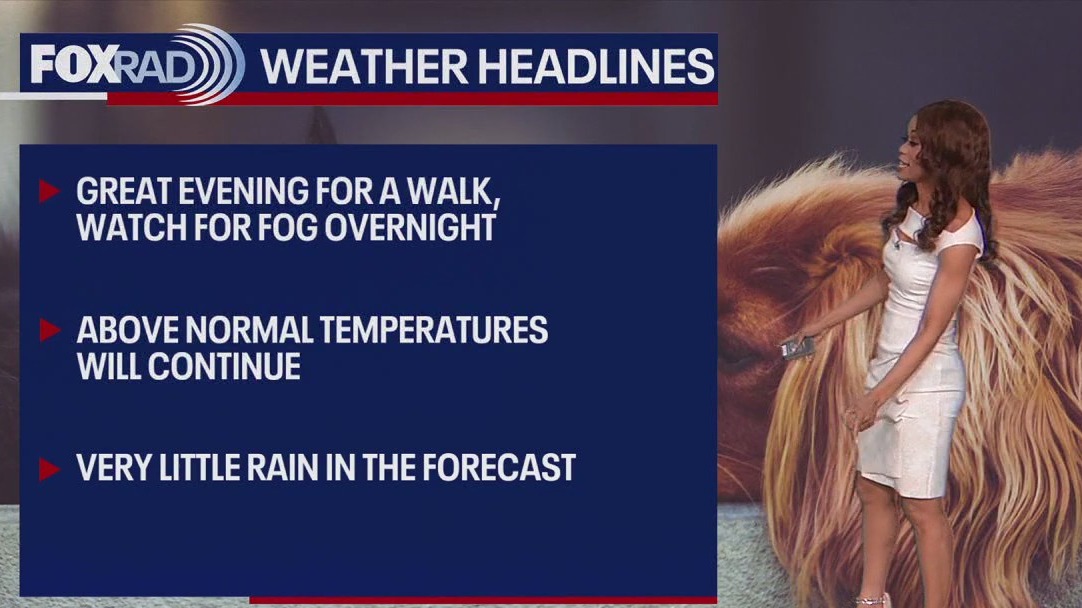
Cool this morning with patchy fog possible, then mostly sunny and warmer with highs in the mid 70s. Watch for areas of dense fog this morning (and probably more tonight). The rest of the day looks great and this spring-like weather will stay with us through the start of the rodeo. Rain chances are very low and temps will be very comfortable for the BBQ cookoff and the rodeo parade on Saturday.
Cool this morning with patchy fog possible, then mostly sunny and warmer with highs in the mid 70s. Watch for areas of dense fog this morning (and probably more tonight). The rest of the day looks great and this spring-like weather will stay with us through the start of the rodeo. Rain chances are very low and temps will be very comfortable for the BBQ cookoff and the rodeo parade on Saturday.


FOX 26 Houston Weather Forecast
Cool this morning with patchy fog possible, then mostly sunny and warmer with highs in the mid 70s. Watch for areas of dense fog this morning (and probably more tonight). The rest of the day looks great and this spring-like weather will stay with us through the start of the rodeo. Rain chances are very low and temps will be very comfortable for the BBQ cookoff and the rodeo parade on Saturday.
Cool this morning with patchy fog possible, then mostly sunny and warmer with highs in the mid 70s. Watch for areas of dense fog this morning (and probably more tonight). The rest of the day looks great and this spring-like weather will stay with us through the start of the rodeo. Rain chances are very low and temps will be very comfortable for the BBQ cookoff and the rodeo parade on Saturday.


FOX 26 Houston Weather Forecast
Cool this morning with patchy fog possible, then mostly sunny and warmer with highs in the mid 70s.
Cool this morning with patchy fog possible, then mostly sunny and warmer with highs in the mid 70s.


FOX 26 Houston Weather Forecast
Weather for your Presidents Day evening should be cool and quiet with clear skies and temperatures dipping to the 40s. With a south breeze increasing the next few days, look for much warmer temperatures in the 70s Tuesday and even low 80s Wednesday and Thursday. That means warm weather for trail riders heading towards Houston to help start the 2024 Rodeo Season. Only chance for rain this week will be with a cold front that will bring a very small 10% rain chance on Thursday. That means mild and dry weather for Go Texan Day Friday and for any weekend plans!
Weather for your Presidents Day evening should be cool and quiet with clear skies and temperatures dipping to the 40s. With a south breeze increasing the next few days, look for much warmer temperatures in the 70s Tuesday and even low 80s Wednesday and Thursday. That means warm weather for trail riders heading towards Houston to help start the 2024 Rodeo Season. Only chance for rain this week will be with a cold front that will bring a very small 10% rain chance on Thursday. That means mild and dry weather for Go Texan Day Friday and for any weekend plans!


FOX 26 Houston Weather Forecast
. Weather for your Presidents Day evening should be cool and quiet with clear skies and temperatures dipping to the 40s. With a south breeze increasing the next few days, look for much warmer temperatures in the 70s Tuesday and even low 80s Wednesday and Thursday. That means warm weather for trail riders heading towards Houston to help start the 2024 Rodeo Season. Only chance for rain this week will be with a cold front that will bring a very small 10% rain chance on Thursday. That means mild and dry weather for Go Texan Day Friday and for any weekend plans
. Weather for your Presidents Day evening should be cool and quiet with clear skies and temperatures dipping to the 40s. With a south breeze increasing the next few days, look for much warmer temperatures in the 70s Tuesday and even low 80s Wednesday and Thursday. That means warm weather for trail riders heading towards Houston to help start the 2024 Rodeo Season. Only chance for rain this week will be with a cold front that will bring a very small 10% rain chance on Thursday. That means mild and dry weather for Go Texan Day Friday and for any weekend plans


FOX 26 Houston Weather Forecast
After a frosty morning, the outlook for Presidents Day and this week will be spring-like with a sunny and warmer pattern through the start of the rodeo. Enjoy pleasant, dry afternoon in the 70s and even some low 80s. With only a slight chance for showers on Thursday, the forecast overall looks fantastic.
After a frosty morning, the outlook for Presidents Day and this week will be spring-like with a sunny and warmer pattern through the start of the rodeo. Enjoy pleasant, dry afternoon in the 70s and even some low 80s. With only a slight chance for showers on Thursday, the forecast overall looks fantastic.


Fox 26 Houston Weather Forecast
After a frosty morning, the outlook for Presidents Day and this week will be spring-like with a sunny and warmer pattern through the start of the rodeo. Enjoy pleasant, dry afternoon in the 70s and even some low 80s. With only a slight chance for showers on Thursday, the forecast overall looks fantastic.
After a frosty morning, the outlook for Presidents Day and this week will be spring-like with a sunny and warmer pattern through the start of the rodeo. Enjoy pleasant, dry afternoon in the 70s and even some low 80s. With only a slight chance for showers on Thursday, the forecast overall looks fantastic.


FOX 26 Houston Weather Forecast
After a frosty morning, the outlook for Presidents Day and this week will be spring-like with a sunny and warmer pattern through the start of the rodeo. Enjoy pleasant, dry afternoon in the 70s and even some low 80s. With only a slight chance for showers on Thursday, the forecast overall looks fantastic.
After a frosty morning, the outlook for Presidents Day and this week will be spring-like with a sunny and warmer pattern through the start of the rodeo. Enjoy pleasant, dry afternoon in the 70s and even some low 80s. With only a slight chance for showers on Thursday, the forecast overall looks fantastic.


FOX 26 Houston Weather Forecast
Get ready for one more chilly night before a big rebound with our temperatures! With clear skies and light wind, Houston should dip to the middle to upper 30s tonight with a light freeze possible N/NW of Houston around Conroe, Huntsville and Brenham. High pressure will keep our weather sunny and quiet for Presidents Day with afternoon temperatures soaring to the middle to upper 60s. Southerly flow increases through the week which means more heat and humidity. Temperatures will be well above normal by Wednesday and Thursday with highs in the low 80s. Overall, this week will feature warmer and drier than average weather. Cold front moves in late Thursday but is not expected to bring any rain. It will bring a slight drop in temperatures for the upcoming weekend. At least weather looks quiet for big events this week like Trail Rides, BBQ Cookoff and Go Texan Day leading up to the start of the Houston Rodeo Season!
Get ready for one more chilly night before a big rebound with our temperatures! With clear skies and light wind, Houston should dip to the middle to upper 30s tonight with a light freeze possible N/NW of Houston around Conroe, Huntsville and Brenham. High pressure will keep our weather sunny and quiet for Presidents Day with afternoon temperatures soaring to the middle to upper 60s. Southerly flow increases through the week which means more heat and humidity. Temperatures will be well above normal by Wednesday and Thursday with highs in the low 80s. Overall, this week will feature warmer and drier than average weather. Cold front moves in late Thursday but is not expected to bring any rain. It will bring a slight drop in temperatures for the upcoming weekend. At least weather looks quiet for big events this week like Trail Rides, BBQ Cookoff and Go Texan Day leading up to the start of the Houston Rodeo Season!