

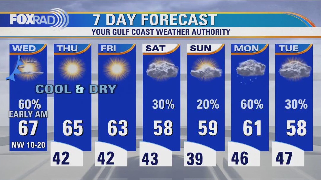

After Wednesday morning rain, cold front brings clear, dry, cooler weather
After early morning rain, a cold front will bring clear, very dry and cooler weather. Look for afternoon sun with breezy northwest winds today. Lows over the next several nights will drop to the upper 30s and low 40s with highs in the mid 60s. The pattern through Christmas still looks cold.
After early morning rain, a cold front will bring clear, very dry and cooler weather. Look for afternoon sun with breezy northwest winds today. Lows over the next several nights will drop to the upper 30s and low 40s with highs in the mid 60s. The pattern through Christmas still looks cold.
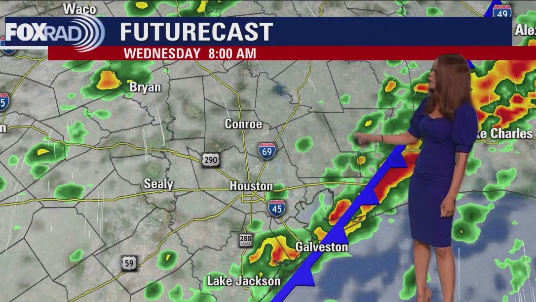

Wednesday morning weather forecast
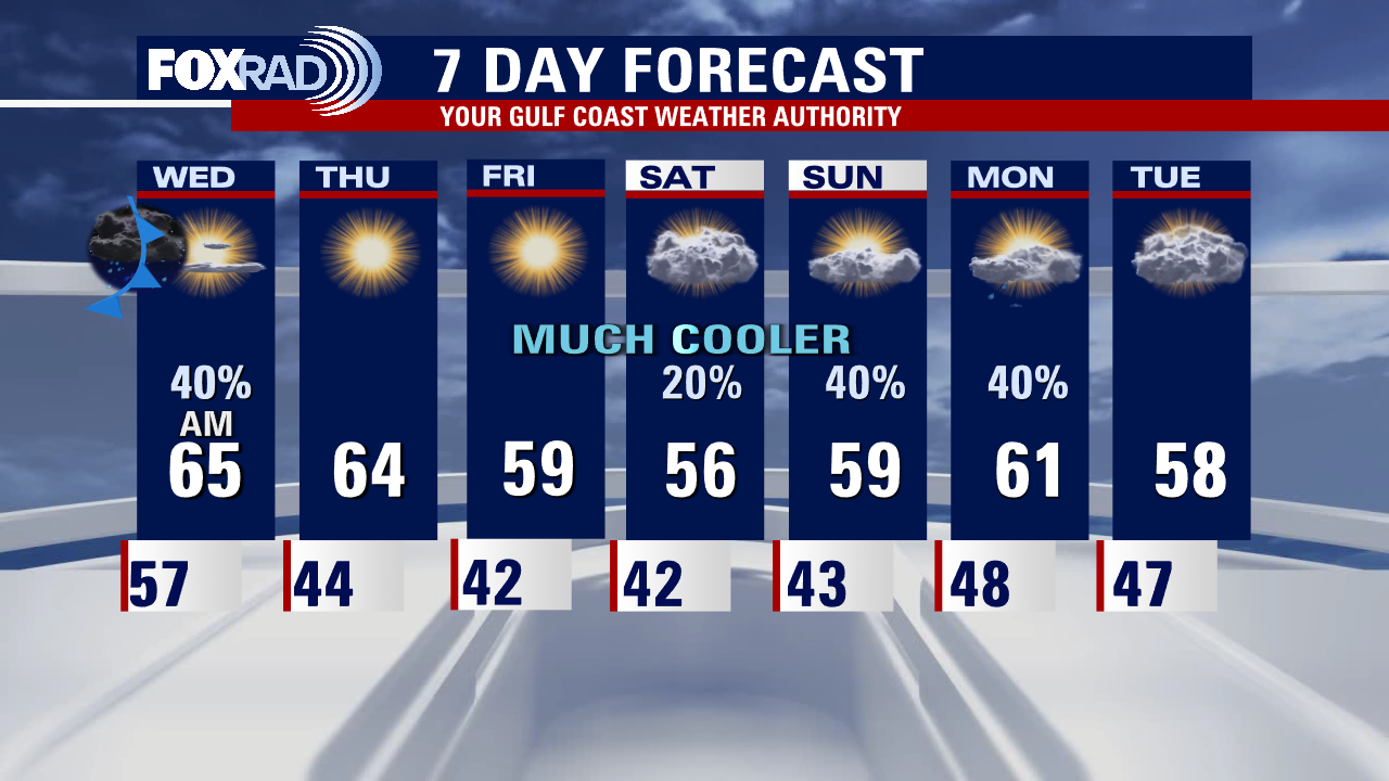
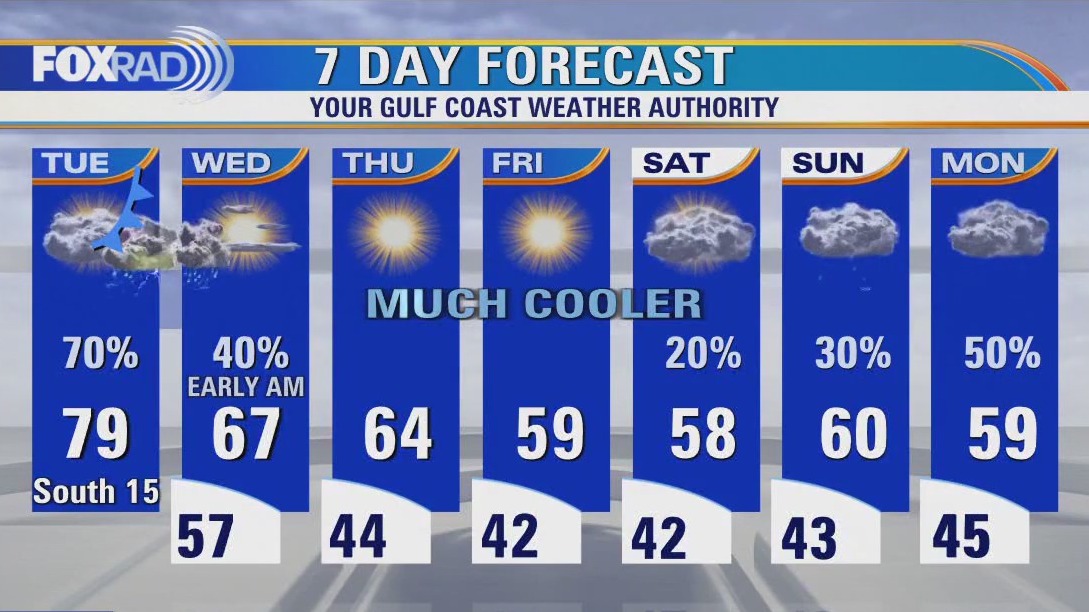
A cold front will usher in much cooler and breezy conditions for the rest of the week. We set another record high at Houston Hobby Airport Tuesday reaching 82 degrees. But the heatwave is coming to an end. Look for more rain possible over the weekend with cooler temperatures sticking around.
A cold front will usher in much cooler and breezy conditions for the rest of the week. We set another record high at Houston Hobby Airport Tuesday reaching 82 degrees. But the heatwave is coming to an end. Look for more rain possible over the weekend with cooler temperatures sticking around.


EF-2 tornado captured on video, homes damaged in Decatur
A confirmed EF-2 tornado caused major damage in Wise County just southeast of Decatur. At least two people were hurt as a result of the tornado with peak wind gusts of 125 miles per hour.
A confirmed EF-2 tornado caused major damage in Wise County just southeast of Decatur. At least two people were hurt as a result of the tornado with peak wind gusts of 125 miles per hour.

Tuesday evening weather forecast with Meteorologist Remeisha Shade
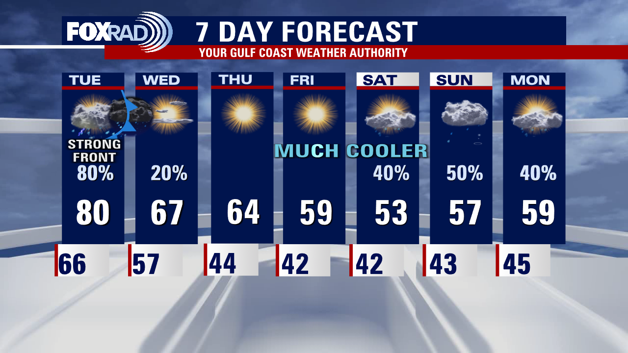
Tornado Watch remains in effect until 10 PM for Polk county. There's still a small risk for a brief tornado and a few damaging wind gusts through early tonight as a strong cold front moves in. The main event for the late night hours will be the potential for heavy rain that could lead to a few flooding issues. Cold front ushers in much cooler and breezy conditions for the rest of the week. We set another record high at Houston Hobby Airport today reaching 82 degrees. But the heatwave is coming to an end. Look for more rain possible over the weekend with cooler temperatures sticking around.
Tornado Watch remains in effect until 10 PM for Polk county. There's still a small risk for a brief tornado and a few damaging wind gusts through early tonight as a strong cold front moves in. The main event for the late night hours will be the potential for heavy rain that could lead to a few flooding issues. Cold front ushers in much cooler and breezy conditions for the rest of the week. We set another record high at Houston Hobby Airport today reaching 82 degrees. But the heatwave is coming to an end. Look for more rain possible over the weekend with cooler temperatures sticking around.


Severe weather: 5 tornadoes confirmed in North Texas, possibly as many 12
There is damage in several places across North Texas with a storm system leading to multiple tornadoes. The National Weather Service says 5 tornadoes have been confirmed so far in North Texas, as many as 12 may have occurred on Tuesday.
There is damage in several places across North Texas with a storm system leading to multiple tornadoes. The National Weather Service says 5 tornadoes have been confirmed so far in North Texas, as many as 12 may have occurred on Tuesday.


What are the odds of a white Christmas?
In order to qualify for a white Christmas, there must either be at least 1 inch of snow on the ground on Christmas morning or falling snow must accumulate to at least 0.1 inches on Dec. 25.
In order to qualify for a white Christmas, there must either be at least 1 inch of snow on the ground on Christmas morning or falling snow must accumulate to at least 0.1 inches on Dec. 25.


Adorable video: Police dog attempts to shovel snow in Vermont
Police posted the video on Facebook, joking that the dog, identified as K9 Nova, was excited to announce her new job with Public Works.
Police posted the video on Facebook, joking that the dog, identified as K9 Nova, was excited to announce her new job with Public Works.
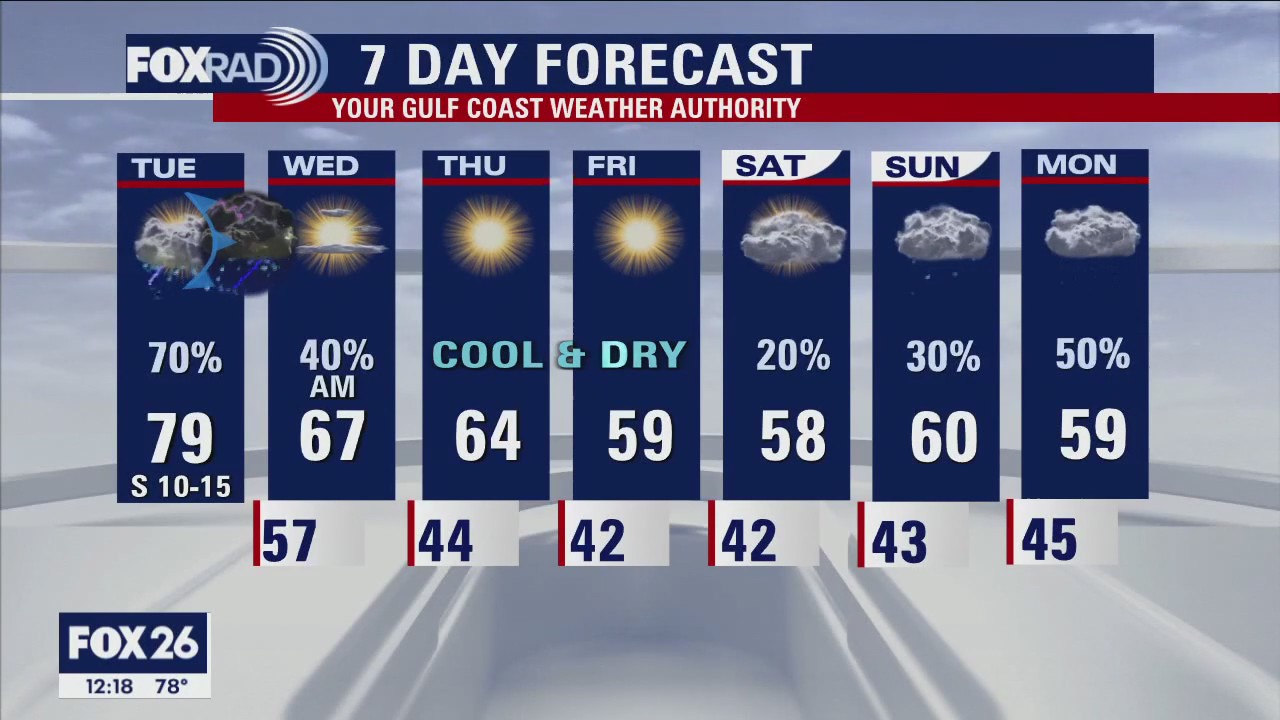

Tuesday afternoon weather forecast with Meteorologist John Dawson
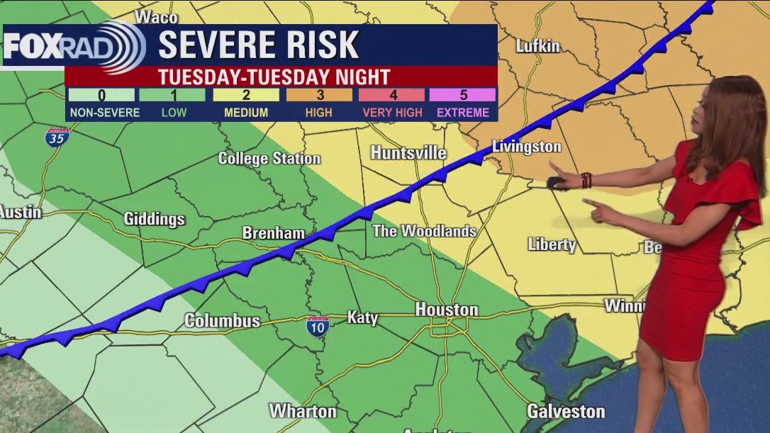
Big changes are on the way and we expect several cold fronts to keep the forecast interesting here for the rest of 2022. Today's main concern is severe weather which could begin by early afternoon and last off and on through overnight tonight. The highest risk will be north of Houston, then northeast by this evening. After the front passes Wednesday morning, we'll enter a chillier pattern lows in the 40s and highs in the 50s and 60s.
Big changes are on the way and we expect several cold fronts to keep the forecast interesting here for the rest of 2022. Today's main concern is severe weather which could begin by early afternoon and last off and on through overnight tonight. The highest risk will be north of Houston, then northeast by this evening. After the front passes Wednesday morning, we'll enter a chillier pattern lows in the 40s and highs in the 50s and 60s.

Big changes on the way for Houston
Big changes are on the way and we expect several cold fronts to keep the forecast interesting here for the rest of 2022. Today's main concern is severe weather which could begin by early afternoon and last off and on through overnight tonight. The highest risk will be north of Houston, then northeast by this evening. After the front passes Wednesday morning, we'll enter a chillier pattern lows in the 40s and highs in the 50s and 60s.
Big changes are on the way and we expect several cold fronts to keep the forecast interesting here for the rest of 2022. Today's main concern is severe weather which could begin by early afternoon and last off and on through overnight tonight. The highest risk will be north of Houston, then northeast by this evening. After the front passes Wednesday morning, we'll enter a chillier pattern lows in the 40s and highs in the 50s and 60s.

Tuesday morning weather forecast
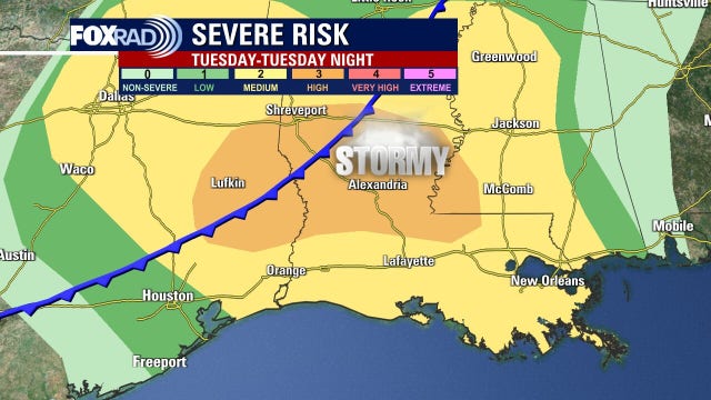
Big changes are less than 24 hours away as a powerful winter storm gets more organized across the Rockies. This powerful storm system will bring blizzard conditions to parts of the Plains and Dakotas on the colder side. We will be on the warmer side of the storm meaning the threat for heavy rain and possible severe storms. Severe threat is low for Houston, Cat. 1 out of 5 but a higher Category 2 out of 5 just NE of Houston. Main threats will be damaging winds and a very small tornado threat mainly Tuesday afternoon and evening. Heavy rain will be a possibility as well with parts of Montgomery, Polk & San Jacinto counties picking up 3-7.5" of rain over the weekend. Big temperature drop comes mid-late week as high temperatures dip to the 50s by the weekend. Prepare for it to feel more like the holidays soon!
Big changes are less than 24 hours away as a powerful winter storm gets more organized across the Rockies. This powerful storm system will bring blizzard conditions to parts of the Plains and Dakotas on the colder side. We will be on the warmer side of the storm meaning the threat for heavy rain and possible severe storms. Severe threat is low for Houston, Cat. 1 out of 5 but a higher Category 2 out of 5 just NE of Houston. Main threats will be damaging winds and a very small tornado threat mainly Tuesday afternoon and evening. Heavy rain will be a possibility as well with parts of Montgomery, Polk & San Jacinto counties picking up 3-7.5" of rain over the weekend. Big temperature drop comes mid-late week as high temperatures dip to the 50s by the weekend. Prepare for it to feel more like the holidays soon!

Monday evening weather forecast with Meteorologist Remeisha Shade
Big changes are less than 24 hours away as a powerful winter storm gets more organized across the Rockies. This powerful storm system will bring blizzard conditions to parts of the Plains and Dakotas on the colder side. We will be on the warmer side of the storm meaning the threat for heavy rain and possible severe storms. Severe threat is low for Houston, Cat. 1 out of 5 but a higher Category 2 out of 5 just NE of Houston. Main threats will be damaging winds and a very small tornado threat mainly Tuesday afternoon and evening. Heavy rain will be a possibility as well with parts of Montgomery, Polk & San Jacinto counties picking up 3-7.5" of rain over the weekend. Big temperature drop comes mid-late week as high temperatures dip to the 50s by the weekend. Prepare for it to feel more like the holidays soon!
Big changes are less than 24 hours away as a powerful winter storm gets more organized across the Rockies. This powerful storm system will bring blizzard conditions to parts of the Plains and Dakotas on the colder side. We will be on the warmer side of the storm meaning the threat for heavy rain and possible severe storms. Severe threat is low for Houston, Cat. 1 out of 5 but a higher Category 2 out of 5 just NE of Houston. Main threats will be damaging winds and a very small tornado threat mainly Tuesday afternoon and evening. Heavy rain will be a possibility as well with parts of Montgomery, Polk & San Jacinto counties picking up 3-7.5" of rain over the weekend. Big temperature drop comes mid-late week as high temperatures dip to the 50s by the weekend. Prepare for it to feel more like the holidays soon!

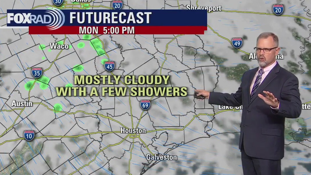
Powerful coast-to-coast storm system reaches Houston Tuesday afternoon
Showers and thunderstorms ahead of the front reach Southeast Texas Tuesday afternoon and continue into Tuesday night. There is a slight risk of severe storms with most of the stronger storms east of I-45.
Showers and thunderstorms ahead of the front reach Southeast Texas Tuesday afternoon and continue into Tuesday night. There is a slight risk of severe storms with most of the stronger storms east of I-45.


Spectacular wave-like clouds form over Wyoming mountains
Some spectacular cloud formations in Wyoming were so inviting you could almost surf them.
Some spectacular cloud formations in Wyoming were so inviting you could almost surf them.
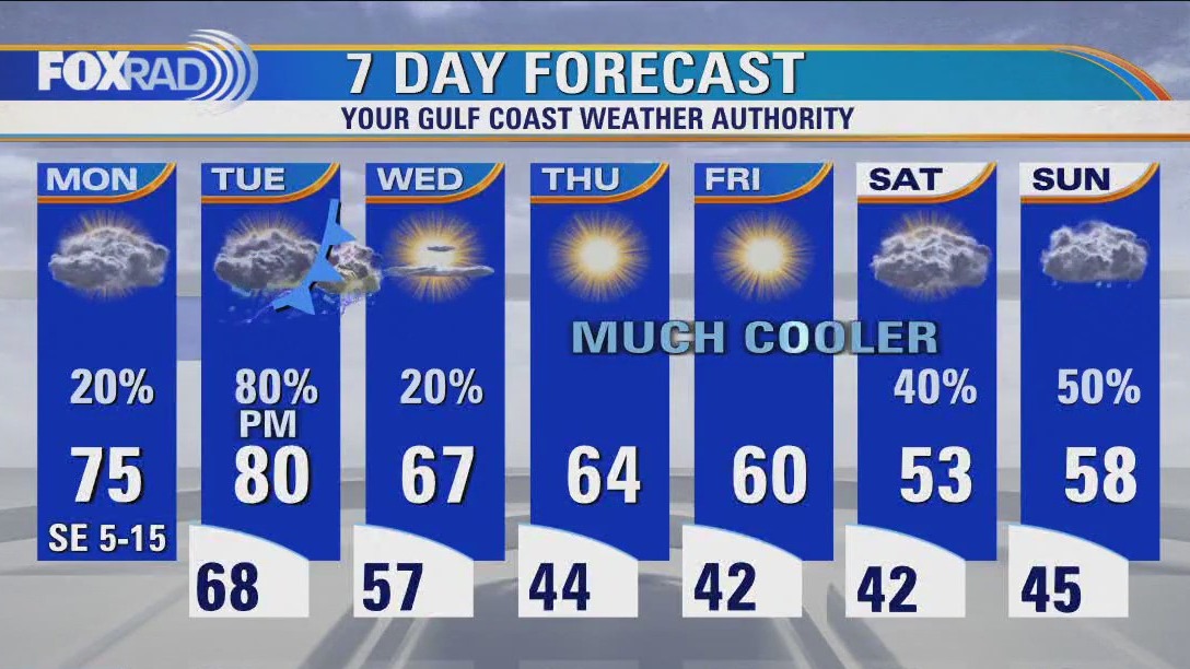

Cloudy and slightly cooler Monday morning, then isolated showers
Big changes are on the way with a powerful area of low pressure that will bring a blizzard to the Central Plains and severe storms from Texas to Arkansas, Louisiana and Mississippi. Look for a mostly quiet, cloudy Monday here with a few light showers. Tuesday brings a chance for storms, especially by the afternoon and evening and a few could be strong. The highest risk for severe weather will be northeast of Houston. The rest of the week will be much cooler with lows in the 40s and highs in the 50s and 60s.
Big changes are on the way with a powerful area of low pressure that will bring a blizzard to the Central Plains and severe storms from Texas to Arkansas, Louisiana and Mississippi. Look for a mostly quiet, cloudy Monday here with a few light showers. Tuesday brings a chance for storms, especially by the afternoon and evening and a few could be strong. The highest risk for severe weather will be northeast of Houston. The rest of the week will be much cooler with lows in the 40s and highs in the 50s and 60s.

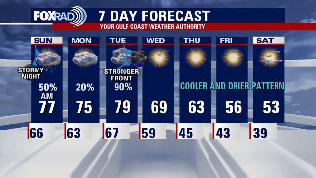
Mostly cloudy in the 60s Sunday afternoon with few showers
Houston will continue to see a few showers around until a cold front arrives Tuesday afternoon. That front will create some severe storms with some of those possible in Southeast Texas. Locally heavy rainfall is also possible late on Tuesday. Skies will gradually clear on Wednesday as some chilly weather moves into the area for the rest of the week.
Houston will continue to see a few showers around until a cold front arrives Tuesday afternoon. That front will create some severe storms with some of those possible in Southeast Texas. Locally heavy rainfall is also possible late on Tuesday. Skies will gradually clear on Wednesday as some chilly weather moves into the area for the rest of the week.
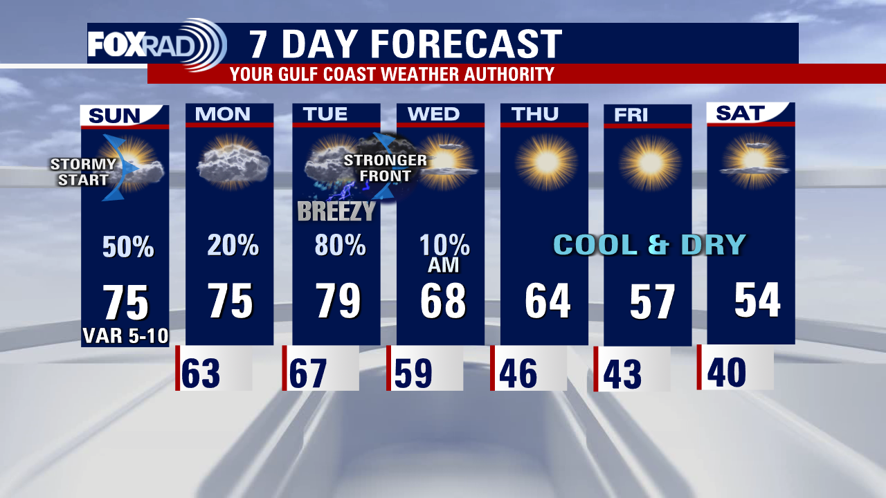

Sunday weather forecast with Meteorologist Lena Maria Arango
This week will feature quite the pattern flip, from warm and humid to cool and dry. After a stormy start to Sunday, the rain will remain fairly Isolated until Tuesday when our next front arrives. That will bring in another dose of strong to potentially severe storms, mainly east, and the possibility for more locally heavy rainfall. A sprinkle or two may linger into the early part of Wednesday then skies will gradually clear as festive weather arrives. Some chilly starts in the upper 30s are possible farther north toward the end of the week and heading into the weekend.
This week will feature quite the pattern flip, from warm and humid to cool and dry. After a stormy start to Sunday, the rain will remain fairly Isolated until Tuesday when our next front arrives. That will bring in another dose of strong to potentially severe storms, mainly east, and the possibility for more locally heavy rainfall. A sprinkle or two may linger into the early part of Wednesday then skies will gradually clear as festive weather arrives. Some chilly starts in the upper 30s are possible farther north toward the end of the week and heading into the weekend.

Cold front bringing storms to Houston area early Sunday morning
A cold front will bringing a broken line of storms into the Houston area overnight into early Sunday morning. The rain should end around noon and milder temperatures will hang around Southeast Texas until a stronger front arrives on Tuesday. That will begin a much cooler and drier pattern.
A cold front will bringing a broken line of storms into the Houston area overnight into early Sunday morning. The rain should end around noon and milder temperatures will hang around Southeast Texas until a stronger front arrives on Tuesday. That will begin a much cooler and drier pattern.

House advances giant Texas storm surge project in water bill
The House passed the $858 billion defense bill by a vote of 350-80. The Texas coastal protection project far outstrips any of the 24 other projects greenlit by the bill.
The House passed the $858 billion defense bill by a vote of 350-80. The Texas coastal protection project far outstrips any of the 24 other projects greenlit by the bill.

Saturday weather forecast with Meteorologist Lena Maria Arango
Still warm and humid, but changes are on the horizon. Rain chances are also going up. The first half of Saturday looks good for outdoor plans, and so does the second half of Sunday. But overnight tonight some locally heavy rain will fall with a slow-moving front. That will be mainly north of town, along with the possibility of a few stronger storms. Something to keep in mind if you'll be out and about after dark: we'll be quiet through Monday, before the next potential for severe weather arrives. Check back often for updates on Tuesday, and if you're craving cooler air don't worry... it's coming
Still warm and humid, but changes are on the horizon. Rain chances are also going up. The first half of Saturday looks good for outdoor plans, and so does the second half of Sunday. But overnight tonight some locally heavy rain will fall with a slow-moving front. That will be mainly north of town, along with the possibility of a few stronger storms. Something to keep in mind if you'll be out and about after dark: we'll be quiet through Monday, before the next potential for severe weather arrives. Check back often for updates on Tuesday, and if you're craving cooler air don't worry... it's coming

Saturday morning weather forecast
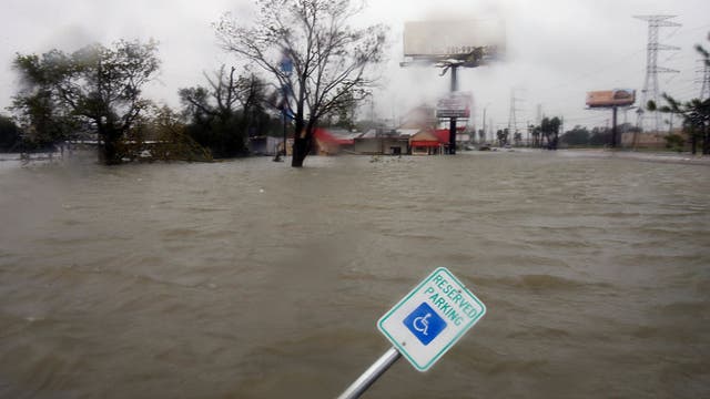
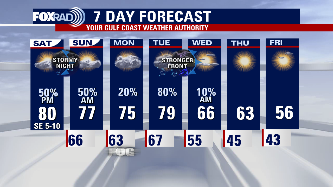
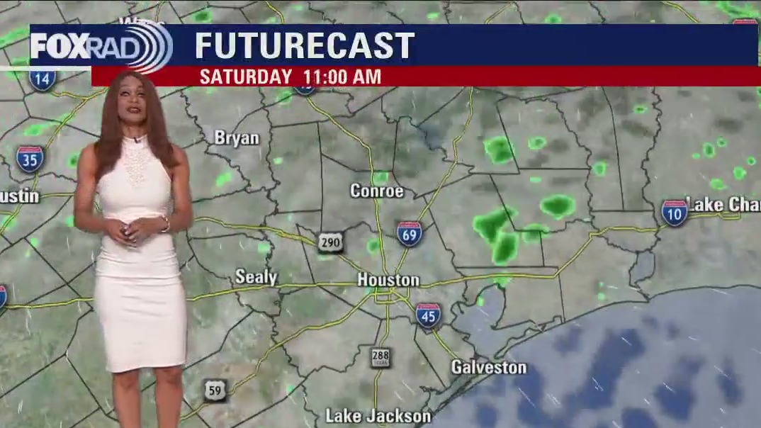
Two big rounds of rain are expected to roll through over the next 5 days. The first round comes with a weaker cold front late Saturday night into Sunday. A few strong storms could also accompany this front. A much stronger front Tuesday brings even higher rain chances and finally much cooler air by the middle of next week. It will be close to a 20 degree drop so get ready!
Two big rounds of rain are expected to roll through over the next 5 days. The first round comes with a weaker cold front late Saturday night into Sunday. A few strong storms could also accompany this front. A much stronger front Tuesday brings even higher rain chances and finally much cooler air by the middle of next week. It will be close to a 20 degree drop so get ready!