


Survivors of Turkey, Syria earthquake struggle to stay warm and fed
Turkish authorities said the death toll had risen to more than 16,100 in the country, with more than 64,000 injured. Survivors gathered around campfires and clamored for food and water in the cold temperatures.
Turkish authorities said the death toll had risen to more than 16,100 in the country, with more than 64,000 injured. Survivors gathered around campfires and clamored for food and water in the cold temperatures.
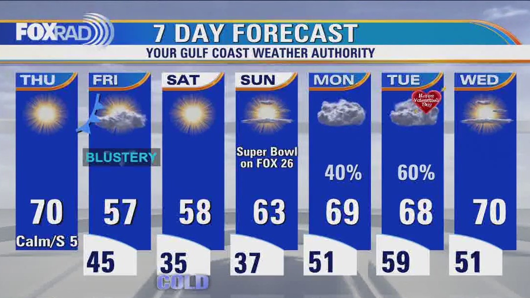

Houston weather: Cold Thursday morning, then sunny with highs near 70
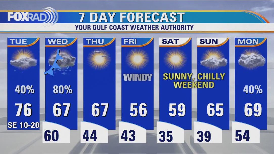
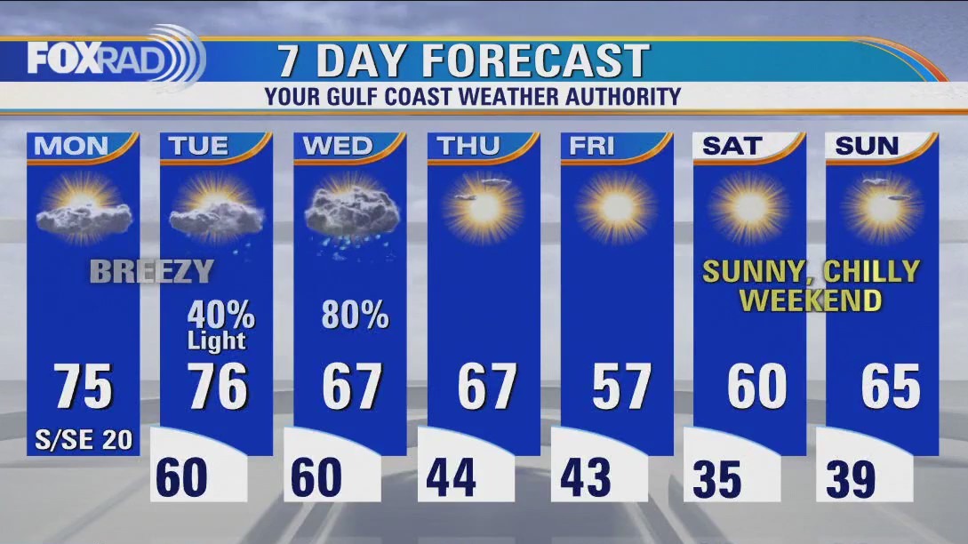
Yesterday's cold front has ushered in cooler and drier conditions, but after a cold morning, this afternoon looks great. A second cold front is expected tonight which will cause blustery weather on Friday. This Super Bowl weekend looks cool, but quiet. Watch for lows close to freezing on Saturday morning with cool, dry days through Sunday.
Yesterday's cold front has ushered in cooler and drier conditions, but after a cold morning, this afternoon looks great. A second cold front is expected tonight which will cause blustery weather on Friday. This Super Bowl weekend looks cool, but quiet. Watch for lows close to freezing on Saturday morning with cool, dry days through Sunday.
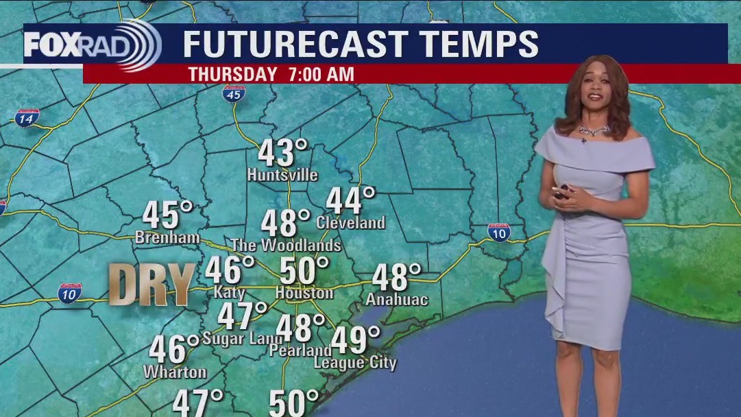

Thursday morning Houston-area weather forecast
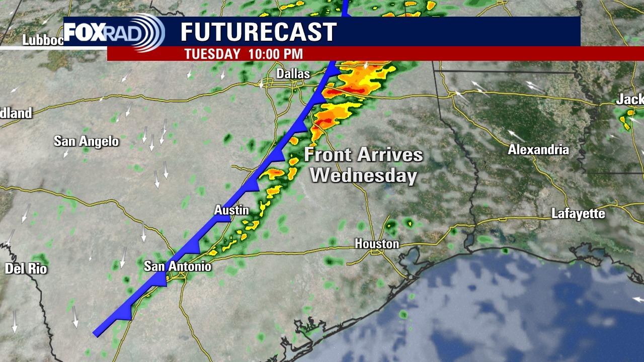
A strong cold front has pushed across SE Texas bringing with it a big drop in temperatures. Another cold front is set to arrive Thursday night but should come through dry. Temps get up to near 70 ahead of that front Thursday before it turns colder heading into the weekend.
A strong cold front has pushed across SE Texas bringing with it a big drop in temperatures. Another cold front is set to arrive Thursday night but should come through dry. Temps get up to near 70 ahead of that front Thursday before it turns colder heading into the weekend.
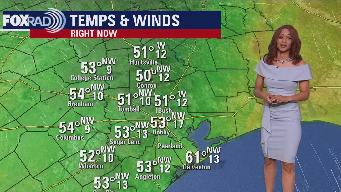

Cool, breezy Wednesday evening in the 50s
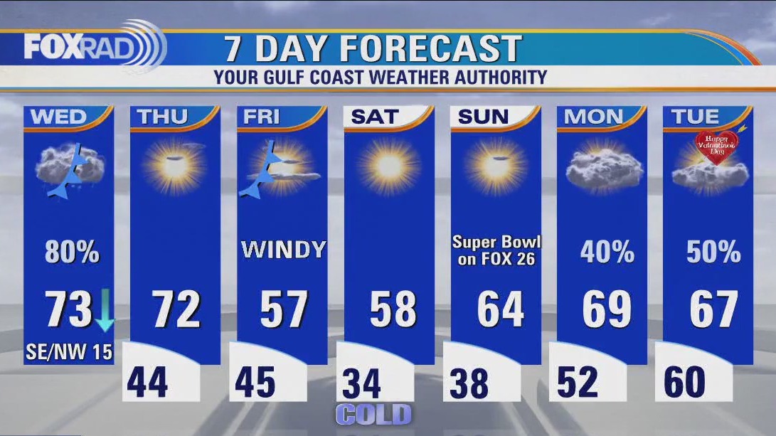
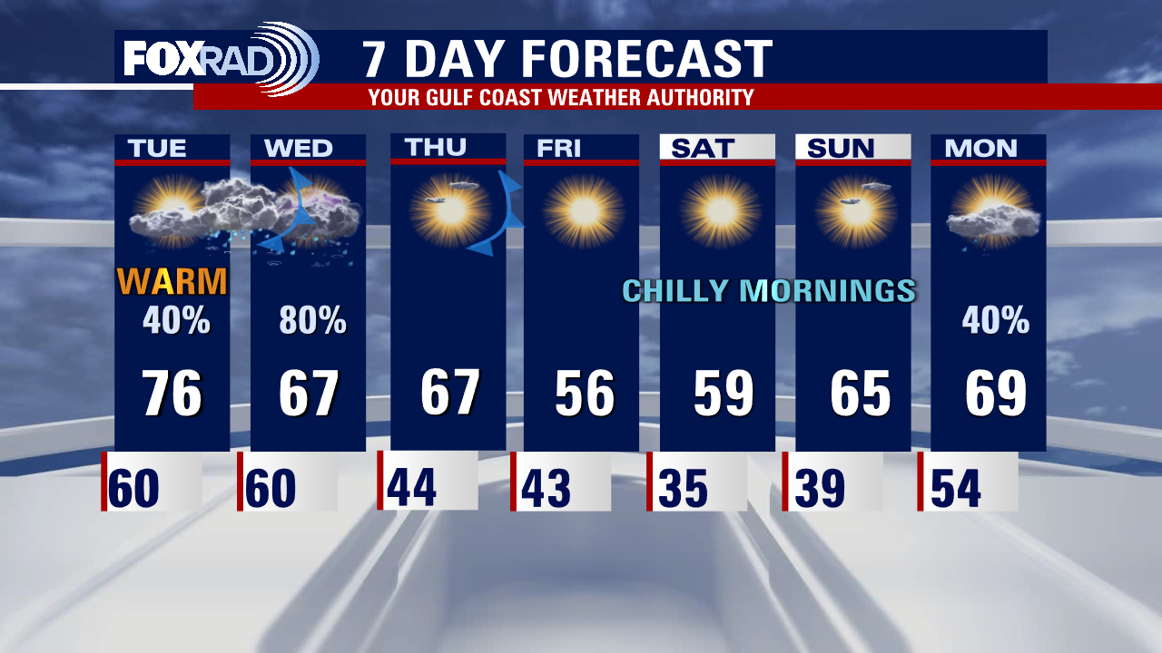
A strong cold front has pushed across SE Texas bringing with it a big drop in temperatures. Temperatures have dropped close to 30 degrees today and it gets even colder tonight with most areas dipping to the 40s. Another cold front is set to arrive Thursday night but should come through dry. Temps get up to near 70 ahead of that front Thursday before it turns colder heading into the weekend. Friday will be much cooler and breezy with wind gusts over 30 mph possible. Coldest temperatures are expected Saturday morning as we get close to freezing. We heat up again next week ahead of another storm system that will bring showers Monday and the chance for rain & a few storms that could impact date plans on Valentine's Day.
A strong cold front has pushed across SE Texas bringing with it a big drop in temperatures. Temperatures have dropped close to 30 degrees today and it gets even colder tonight with most areas dipping to the 40s. Another cold front is set to arrive Thursday night but should come through dry. Temps get up to near 70 ahead of that front Thursday before it turns colder heading into the weekend. Friday will be much cooler and breezy with wind gusts over 30 mph possible. Coldest temperatures are expected Saturday morning as we get close to freezing. We heat up again next week ahead of another storm system that will bring showers Monday and the chance for rain & a few storms that could impact date plans on Valentine's Day.
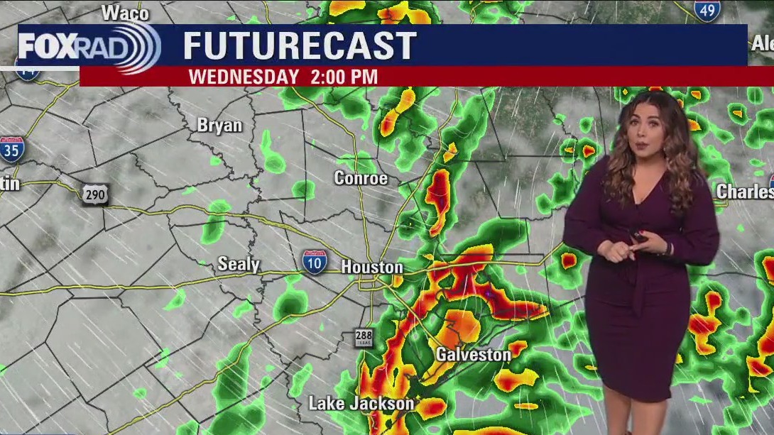

Windy, rainy Wednesday afternoon in the 70s
Cold front is slowly progressing across our area, keeping showers and storms in the forecast through mid-afternoon followed by falling temperatures. A reinforcing dry front will blow into the area Friday, turning things, and chilly for the start of Mardi Gras and Super Bowl Weekend locally especially in the mornings. May want to consider an umbrella for your Valentine, rain chances return early next week.
Cold front is slowly progressing across our area, keeping showers and storms in the forecast through mid-afternoon followed by falling temperatures. A reinforcing dry front will blow into the area Friday, turning things, and chilly for the start of Mardi Gras and Super Bowl Weekend locally especially in the mornings. May want to consider an umbrella for your Valentine, rain chances return early next week.

Houston weather: Cold front moving through Wednesday
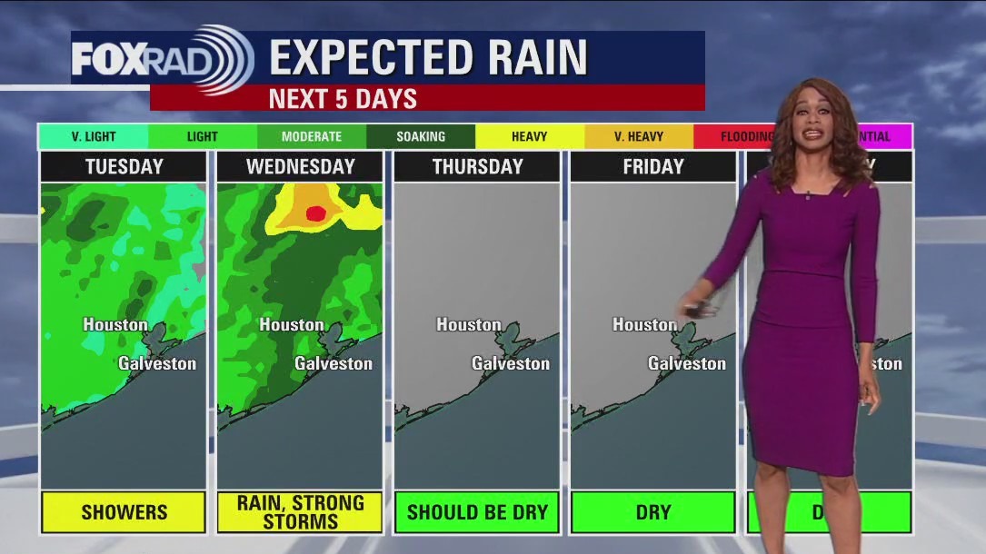
A cold front will move through today, so showers and a few storms are expected along with cooler air sliding in from west to east through the day. This means that temperatures could fall from the mid 70s at midday to the 50s by late afternoon. The forecast for Thursday through Super Bowl Sunday looks pretty nice with sunny, dry days and chilly nights. Two things to note - Friday looks windy and chilly and overnight lows this weekend are expected to reach the 30s, so a very light freeze is possible.
A cold front will move through today, so showers and a few storms are expected along with cooler air sliding in from west to east through the day. This means that temperatures could fall from the mid 70s at midday to the 50s by late afternoon. The forecast for Thursday through Super Bowl Sunday looks pretty nice with sunny, dry days and chilly nights. Two things to note - Friday looks windy and chilly and overnight lows this weekend are expected to reach the 30s, so a very light freeze is possible.

Wednesday morning Houston-area weather forecast
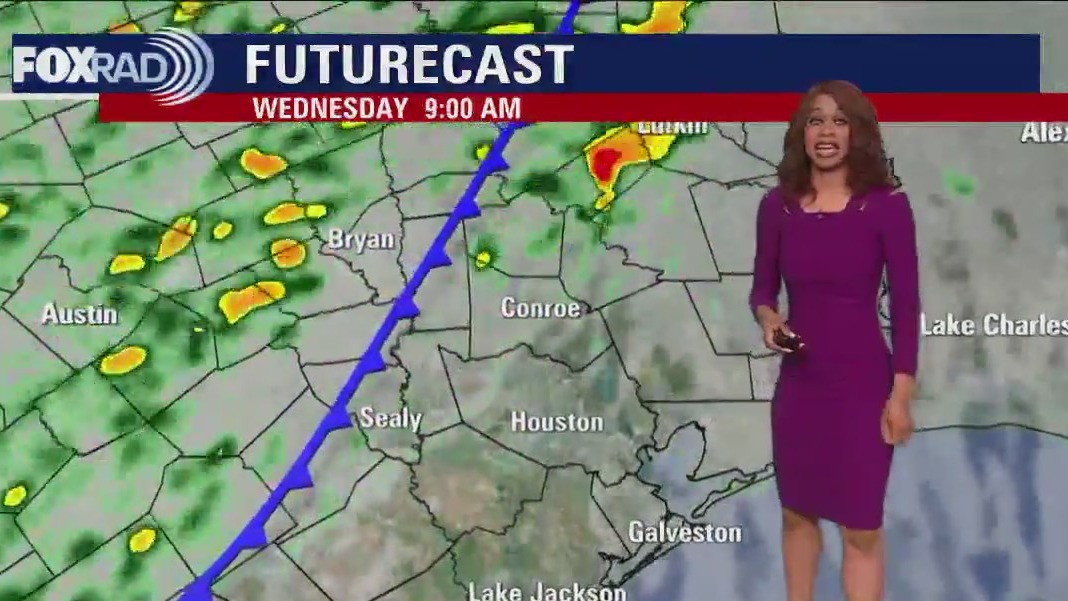
Expect a round of storms Wednesday morning with cold front reaching Houston around midday. Best chance for storms appears to be from around 4 a.m. until noon. A few storms could still be strong to severe Wednesday with a limited Category 1 out of 5 threat for severe storms, including damaging winds and hail. Tornado risk is only around 2%, which means it's possible but unlikely. Few heavy downpours could also accompany the front. We should dry out as we go through Wednesday afternoon. A secondary front will come through dry late Thursday, but bring in even cooler air for the big Super Bowl weekend.
Expect a round of storms Wednesday morning with cold front reaching Houston around midday. Best chance for storms appears to be from around 4 a.m. until noon. A few storms could still be strong to severe Wednesday with a limited Category 1 out of 5 threat for severe storms, including damaging winds and hail. Tornado risk is only around 2%, which means it's possible but unlikely. Few heavy downpours could also accompany the front. We should dry out as we go through Wednesday afternoon. A secondary front will come through dry late Thursday, but bring in even cooler air for the big Super Bowl weekend.


Has there ever been a tropical storm in February? It happened once, 71 years ago, off East Coast
The only known tropical storm to ever roam the Atlantic Basin in February began its initial stages of development on Groundhog Day 1952.
The only known tropical storm to ever roam the Atlantic Basin in February began its initial stages of development on Groundhog Day 1952.

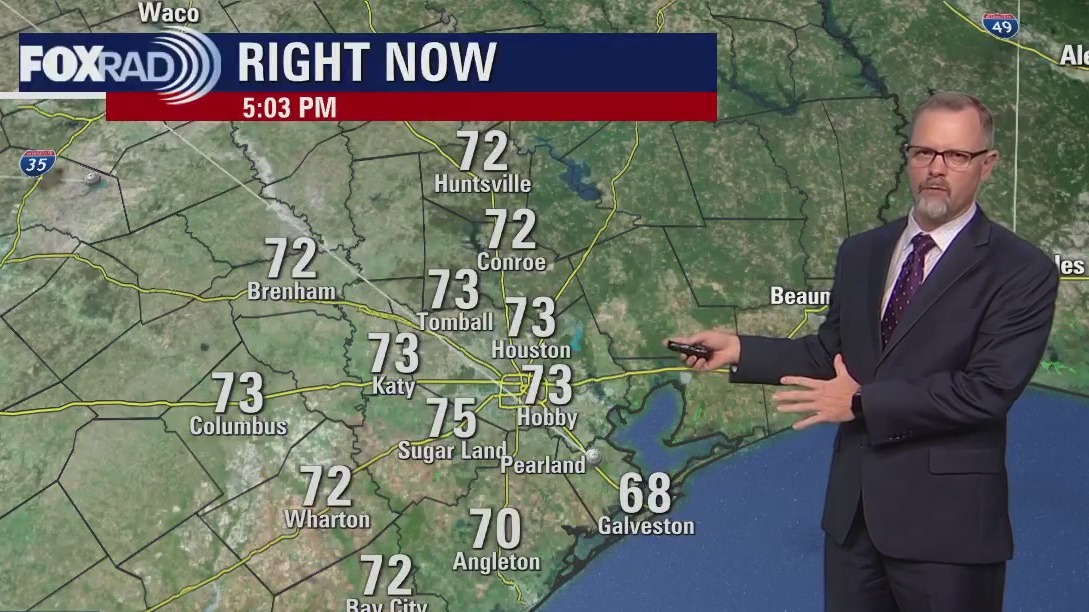
FOX 26 News at 5 p.m. - The News Edge Early Edition
Cold front is still set to move through Wednesday but the timing is a bit slower. Expect scattered showers tonight and a round of storms Wednesday morning with cold front reaching Houston around midday. Best chance for storms appears to be from around 4 a.m. until noon. Temperatures will stay mild tonight near 60 and briefly climb to near 70 tomorrow ahead of the front. A few storms could still be strong to severe Wednesday with a limited Category 1 out of 5 threat for severe storms, including damaging winds and hail. Tornado risk is only around 2% which means it's possible but unlikely. Few heavy downpours could also accompany the front. We should dry out as we go through Wednesday afternoon. A secondary front will come through dry late Thursday but bring in even cooler air for the big Super Bowl weekend.
Cold front is still set to move through Wednesday but the timing is a bit slower. Expect scattered showers tonight and a round of storms Wednesday morning with cold front reaching Houston around midday. Best chance for storms appears to be from around 4 a.m. until noon. Temperatures will stay mild tonight near 60 and briefly climb to near 70 tomorrow ahead of the front. A few storms could still be strong to severe Wednesday with a limited Category 1 out of 5 threat for severe storms, including damaging winds and hail. Tornado risk is only around 2% which means it's possible but unlikely. Few heavy downpours could also accompany the front. We should dry out as we go through Wednesday afternoon. A secondary front will come through dry late Thursday but bring in even cooler air for the big Super Bowl weekend.


Pasadena tornado: Texas Governor submits request for presidential disaster declaration
If the presidential disaster declaration is granted - Harris, Jefferson, Liberty and Orange County residents will be eligible for federal resources.
If the presidential disaster declaration is granted - Harris, Jefferson, Liberty and Orange County residents will be eligible for federal resources.


Here’s a look at the world’s deadliest earthquakes since 2000
A devastating earthquake that impacted Turkey and Syria and killed thousands is the latest to wreak havoc globally. One of the worst since 2000 was an earthquake in Haiti, which left more than 300,000 people dead in 2010.
A devastating earthquake that impacted Turkey and Syria and killed thousands is the latest to wreak havoc globally. One of the worst since 2000 was an earthquake in Haiti, which left more than 300,000 people dead in 2010.

Houston weather: Mostly cloudy, breezy & mild with scattered light showers
A cold front is on the way for early Wednesday and will usher in several days of cool, dry weather. In the meantime, today will be spring-like with scattered showers and a Gulf breeze. The best chance for rain today will be west and north of Houston. A line of strong storms could form overnight into early tomorrow, so Wednesday should begin with inclement weather, but clear, dry weather will move in by Wednesday night. So far, Super Bowl weekend is looking nice, but with cold mornings.
A cold front is on the way for early Wednesday and will usher in several days of cool, dry weather. In the meantime, today will be spring-like with scattered showers and a Gulf breeze. The best chance for rain today will be west and north of Houston. A line of strong storms could form overnight into early tomorrow, so Wednesday should begin with inclement weather, but clear, dry weather will move in by Wednesday night. So far, Super Bowl weekend is looking nice, but with cold mornings.

Tuesday morning Houston-area weather forecast
Springtime warmth has returned to SE Texas with temperatures several degrees above normal today. We stay mild and breezy tonight with a few areas of fog and drizzle possible overnight. Spotty light rain showers will push in throughout the day Tuesday with more warm temps well into the 70s. Next round of storms is set to roll through early Wednesday morning ahead of a cold front. A few storms could be strong to severe with an isolated damaging wind gust and hail. Severe threat is low but still make sure you have the FOX 26 weather app downloaded with alerts turned on for the latest. A secondary front late Thursday will bring in even cooler air late week. But right now, weekend looks awesome for all your Super Bowl watch party plans! Enjoy!
Springtime warmth has returned to SE Texas with temperatures several degrees above normal today. We stay mild and breezy tonight with a few areas of fog and drizzle possible overnight. Spotty light rain showers will push in throughout the day Tuesday with more warm temps well into the 70s. Next round of storms is set to roll through early Wednesday morning ahead of a cold front. A few storms could be strong to severe with an isolated damaging wind gust and hail. Severe threat is low but still make sure you have the FOX 26 weather app downloaded with alerts turned on for the latest. A secondary front late Thursday will bring in even cooler air late week. But right now, weekend looks awesome for all your Super Bowl watch party plans! Enjoy!


Deer Park daycare destroyed during tornado, reopens at church temporarily
Monday marked the start of a new chapter for more than 90 kids at the Joyful Kids Learning Center in Deer Park, as they returned to daycare for the first time in two weeks.
Monday marked the start of a new chapter for more than 90 kids at the Joyful Kids Learning Center in Deer Park, as they returned to daycare for the first time in two weeks.

Monday evening weather forecast with Meteorologist Remeisha Shade
Springtime warmth has returned to SE Texas with temperatures several degrees above normal today. We stay mild and breezy tonight with a few areas of fog and drizzle possible overnight. Spotty light rain showers will push in throughout the day Tuesday with more warm temps well into the 70s. The next round of storms is set to roll through early Wednesday morning ahead of a cold front. A few storms could be strong to severe with an isolated damaging wind gust and hail. Severe threat is low but still make sure you have the FOX 26 weather app downloaded with alerts turned on for the latest. A secondary front late Thursday will bring in even cooler air late week. But right now, the weekend looks awesome for all your Super Bowl watch party plans! Enjoy!
Springtime warmth has returned to SE Texas with temperatures several degrees above normal today. We stay mild and breezy tonight with a few areas of fog and drizzle possible overnight. Spotty light rain showers will push in throughout the day Tuesday with more warm temps well into the 70s. The next round of storms is set to roll through early Wednesday morning ahead of a cold front. A few storms could be strong to severe with an isolated damaging wind gust and hail. Severe threat is low but still make sure you have the FOX 26 weather app downloaded with alerts turned on for the latest. A secondary front late Thursday will bring in even cooler air late week. But right now, the weekend looks awesome for all your Super Bowl watch party plans! Enjoy!


Houston Weather: Showers and storms return to Southeast Texas during middle of the week
After several really nice days in Houston over the weekend, the clear and dry weather will transition to some soggy days.
After several really nice days in Houston over the weekend, the clear and dry weather will transition to some soggy days.

Showers and Storms Return to Southeast Texas during middle of the week
After several really nice days in Houston over the weekend, the clear and dry weather will transition to some soggy days.
After several really nice days in Houston over the weekend, the clear and dry weather will transition to some soggy days.

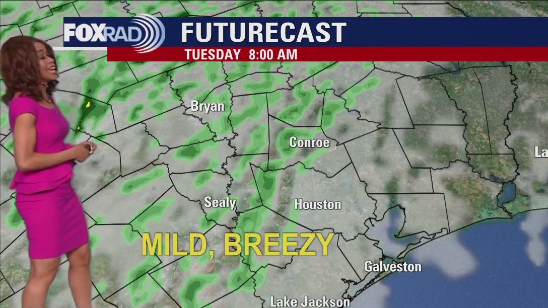
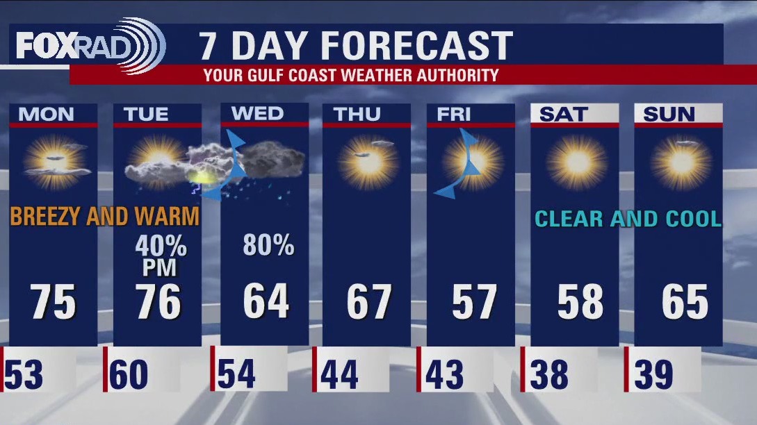
Houston weather: Breezy Monday with highs in mid 70s
We have a breezy Monday on tap with mild winds from the south at around 20 mph and highs in the mid 70s. After some patchy morning fog Tuesday, some scattered light showers are possible, but Wednesday will be more eventful. A cold front should bring a round of storms, with some strong on Wednesday. That front will be followed by a nice, sunny pattern with chilly mornings, especially Saturday.
We have a breezy Monday on tap with mild winds from the south at around 20 mph and highs in the mid 70s. After some patchy morning fog Tuesday, some scattered light showers are possible, but Wednesday will be more eventful. A cold front should bring a round of storms, with some strong on Wednesday. That front will be followed by a nice, sunny pattern with chilly mornings, especially Saturday.

Houston weather: Sunday evening/Monday morning forecast
Two fronts coming this week. The first one arrives Tuesday night and could bring some stormy weather with it. The second front blows in Friday and sets up Houston for a pleasant February weekend.
Two fronts coming this week. The first one arrives Tuesday night and could bring some stormy weather with it. The second front blows in Friday and sets up Houston for a pleasant February weekend.

Warmer temps Sunday evening in the 70s
Two fronts coming this week. The first one arrives Tuesday night and could bring some stormy weather with it. The second front blows in Friday and sets up Houston for a pleasant February weekend.
Two fronts coming this week. The first one arrives Tuesday night and could bring some stormy weather with it. The second front blows in Friday and sets up Houston for a pleasant February weekend.