

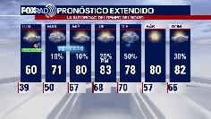

El Tiempo de 19 de Marzo
#FOX26 Meteor?loga Lena Maria Arango tiene su pron?stico para la semana laboral.
#FOX26 Meteor?loga Lena Maria Arango tiene su pron?stico para la semana laboral.


Large chunks of hail damage car in Dallas-Fort Worth area
North Texas continues to clean up this evening after a line of storms hit the area this past week. Several cars and homes were damaged by the storm in Parker County, west of Fort Worth. Cell phone video shows the chunks of hail that fell last Thursday and broke the windshield of a family's only vehicle.
North Texas continues to clean up this evening after a line of storms hit the area this past week. Several cars and homes were damaged by the storm in Parker County, west of Fort Worth. Cell phone video shows the chunks of hail that fell last Thursday and broke the windshield of a family's only vehicle.


Skier 'critically buried' for minutes after triggering avalanche
New Hampshire authorities said the skier was only rescued after another skier saw a hand sticking out from the snow.
New Hampshire authorities said the skier was only rescued after another skier saw a hand sticking out from the snow.


Volunteer shovel brigade clears snowy path to help migrating Yellowstone bison
Nearly five feet of snow fell this winter in West Yellowstone, resulting in giant berms created by snowplows along Highway 191, according to the Buffalo Field Campaign.
Nearly five feet of snow fell this winter in West Yellowstone, resulting in giant berms created by snowplows along Highway 191, according to the Buffalo Field Campaign.


Houston Weather: Sleet falls in Houston Saturday; Your Gulf Coast Weather Authority explains how
Both the National Weather Service and viewers reported sleet pellets mixing in with cold rain on Saturday morning on the south side of town in Houston.
Both the National Weather Service and viewers reported sleet pellets mixing in with cold rain on Saturday morning on the south side of town in Houston.


Freezing Precipitation without Freezing Temperatures, Your Gulf Coast Weather Authority explains
Both the National Weather Service and viewers reported sleet pellets mixing in with a cold rain on Saturday morning on the south side of town in Houston.
Both the National Weather Service and viewers reported sleet pellets mixing in with a cold rain on Saturday morning on the south side of town in Houston.


Break out your jackets for the last weekend of the Houston Rodeo
It's the last weekend of the Houston Livestock Show and Rodeo, and Meteorologist Lena Maria Arango says the weather is finally giving us an opportunity to bust out our flannel and leather.
It's the last weekend of the Houston Livestock Show and Rodeo, and Meteorologist Lena Maria Arango says the weather is finally giving us an opportunity to bust out our flannel and leather.


Break out your jackets for the last weekend of the Houston Rodeo
"It's the last weekend of the Houston Livestock Show and Rodeo, and Meteorologist Lena Maria Arango says the weather is finally giving us an opportunity to bust out our flannel and leather!"
"It's the last weekend of the Houston Livestock Show and Rodeo, and Meteorologist Lena Maria Arango says the weather is finally giving us an opportunity to bust out our flannel and leather!"


Saturday morning Houston-area weather forecast
Strong cold front that moved through Friday morning will mean below normal temperatures through early next week. A weak disturbance will bring a 30% chance for showers Saturday, mainly during the morning and afternoon with high temperatures in the 50s. Sunday should be dry but still mostly cloudy and chilly with temperatures climbing to the 50s. It will be a cool start to Spring on Monday with temperatures 15-20 degrees below normal. Small rain chances will be in the forecast Monday through Wednesday with a warming trend. We bounce back to the 80s by Thursday ahead of our next cold front that should bring rain and a few storms Thursday and Friday. Have a great weekend!
Strong cold front that moved through Friday morning will mean below normal temperatures through early next week. A weak disturbance will bring a 30% chance for showers Saturday, mainly during the morning and afternoon with high temperatures in the 50s. Sunday should be dry but still mostly cloudy and chilly with temperatures climbing to the 50s. It will be a cool start to Spring on Monday with temperatures 15-20 degrees below normal. Small rain chances will be in the forecast Monday through Wednesday with a warming trend. We bounce back to the 80s by Thursday ahead of our next cold front that should bring rain and a few storms Thursday and Friday. Have a great weekend!


Severe storms leave behind extensive damage in Texas, across nation
Another round of rain could impact clean-up efforts in California following this week's atmospheric river. Across the South, severe storms left behind extensive damage. FOX News Correspondent Christina Coleman reports more on the severe weather.
Another round of rain could impact clean-up efforts in California following this week's atmospheric river. Across the South, severe storms left behind extensive damage. FOX News Correspondent Christina Coleman reports more on the severe weather.


Cold, cloudy, breezy Friday afternoon in the 40s, 50s
The bulk of the rain we'll be receiving today has already occurred this morning, look for ending showers but gusty winds linger into tomorrow. Another round of light, scattered showers will be with us early Saturday and cold, cloudy days linger through Monday. You'll want layers for the last few days of Spring Break and the Rodeo! Middle of next week shows a gradual warming trend, possibly curtailed by another late week front.
The bulk of the rain we'll be receiving today has already occurred this morning, look for ending showers but gusty winds linger into tomorrow. Another round of light, scattered showers will be with us early Saturday and cold, cloudy days linger through Monday. You'll want layers for the last few days of Spring Break and the Rodeo! Middle of next week shows a gradual warming trend, possibly curtailed by another late week front.


Severe weather: Gov. Abbott requests SBA disaster relief after he says FEMA denied assistance
Governor Abbott has asked the Small Business Administration to provide disaster relief to Southeast Texans impacted by the recent severe weather.
Governor Abbott has asked the Small Business Administration to provide disaster relief to Southeast Texans impacted by the recent severe weather.


National Weather Service offering free webinars for Hispanic community in Texas
Many National Weather Service offices have teamed up to conduct a series of free webinars entirely in Spanish for the benefit of the Hispanic community in Texas.
Many National Weather Service offices have teamed up to conduct a series of free webinars entirely in Spanish for the benefit of the Hispanic community in Texas.


Houston rodeo forecast for Friday
Storms are moving out but we hang onto a blanket of light-moderate rain through midday. This front drove in chilly air and cloudy skies that will linger through early next week. Overnight Sunday into Monday some inland locations may dip into the 30s, but should stay above freezing. Muggy, warm air returns by middle of next week, with our next front slated to boost rain chances late Thursday/early Friday.
Storms are moving out but we hang onto a blanket of light-moderate rain through midday. This front drove in chilly air and cloudy skies that will linger through early next week. Overnight Sunday into Monday some inland locations may dip into the 30s, but should stay above freezing. Muggy, warm air returns by middle of next week, with our next front slated to boost rain chances late Thursday/early Friday.


Houston weather: Chilly Friday with some rain through midday
Storms are moving out but we hang onto a blanket of light-moderate rain through midday. This front drove in chilly air and cloudy skies that will linger through early next week. Overnight Sunday into Monday some inland locations may dip into the 30s, but should stay above freezing. Muggy, warm air returns by middle of next week, with our next front slated to boost rain chances late Thursday/early Friday.
Storms are moving out but we hang onto a blanket of light-moderate rain through midday. This front drove in chilly air and cloudy skies that will linger through early next week. Overnight Sunday into Monday some inland locations may dip into the 30s, but should stay above freezing. Muggy, warm air returns by middle of next week, with our next front slated to boost rain chances late Thursday/early Friday.


Friday morning Houston-area weather forecast
Threat for severe weather will stick around through early Friday morning. Threat is lowest near the coast and higher farther inland. Strong wind gusts near 60 mph will be the main threat with any storms that reach severe levels with just a low tornado threat. Expect scattered storms through early evening, a bit of a break early tonight then a solid line of rain and storms overnight. The overnight storms will likely reach Brenham & Bryan/College Station around 10-11 pm, Houston around 1 am, and Galveston around 3-4 am. Frequent lightning and heavy rain could also pose some issues with widespread 1-2" totals expected with isolated higher amounts. As the cold front moves through, wind will really pick up with gusts near 40 mph. A WIND ADVISORY is in effect from 1-10 AM Friday. Remember to bring in or tie down lightweight/loose objects around your yard like your trash cans! Bands of rain will still move through Friday morning behind the main line of storms. Most of the rain should push out by lunchtime. Much cooler air builds in Friday with temperatures by evening down into the 40s with wind chills in the 30s! Get ready! Also, make sure to download the FOX 26 Weather App and turn the alerts on so that you'll be up to date!
Threat for severe weather will stick around through early Friday morning. Threat is lowest near the coast and higher farther inland. Strong wind gusts near 60 mph will be the main threat with any storms that reach severe levels with just a low tornado threat. Expect scattered storms through early evening, a bit of a break early tonight then a solid line of rain and storms overnight. The overnight storms will likely reach Brenham & Bryan/College Station around 10-11 pm, Houston around 1 am, and Galveston around 3-4 am. Frequent lightning and heavy rain could also pose some issues with widespread 1-2" totals expected with isolated higher amounts. As the cold front moves through, wind will really pick up with gusts near 40 mph. A WIND ADVISORY is in effect from 1-10 AM Friday. Remember to bring in or tie down lightweight/loose objects around your yard like your trash cans! Bands of rain will still move through Friday morning behind the main line of storms. Most of the rain should push out by lunchtime. Much cooler air builds in Friday with temperatures by evening down into the 40s with wind chills in the 30s! Get ready! Also, make sure to download the FOX 26 Weather App and turn the alerts on so that you'll be up to date!


Winds, some rain expected Thursday along with threat for severe weather
Threat for severe weather will stick around through early Friday morning. Threat is lowest near the coast and higher farther inland. Strong wind gusts near 60 mph will be the main threat with any storms that reach severe levels with just a low tornado threat. Expect scattered storms through early evening, a bit of a break early tonight then a solid line of rain and storms overnight. The overnight storms will likely reach Brenham & Bryan/College Station around 10-11 pm, Houston around 1 am, and Galveston around 3-4 am. Frequent lightning and heavy rain could also pose some issues with widespread 1-2" totals expected with isolated higher amounts. As the cold front moves through, wind will really pick up with gusts near 40 mph. A Wind Advisory is in effect from 1-10 AM Friday. Remember to bring in or tie down lightweight/loose objects around your yard like your trash cans! Bands of rain will still move through Friday morning behind the main line of storms. Most of the rain should push out by lunchtime. Much cooler air builds in Friday with temperatures by evening down into the 40s with wind chills in the 30s! Get ready! Also, make sure to download the FOX 26 Weather App and turn the alerts on so that you'll be up to date!
Threat for severe weather will stick around through early Friday morning. Threat is lowest near the coast and higher farther inland. Strong wind gusts near 60 mph will be the main threat with any storms that reach severe levels with just a low tornado threat. Expect scattered storms through early evening, a bit of a break early tonight then a solid line of rain and storms overnight. The overnight storms will likely reach Brenham & Bryan/College Station around 10-11 pm, Houston around 1 am, and Galveston around 3-4 am. Frequent lightning and heavy rain could also pose some issues with widespread 1-2" totals expected with isolated higher amounts. As the cold front moves through, wind will really pick up with gusts near 40 mph. A Wind Advisory is in effect from 1-10 AM Friday. Remember to bring in or tie down lightweight/loose objects around your yard like your trash cans! Bands of rain will still move through Friday morning behind the main line of storms. Most of the rain should push out by lunchtime. Much cooler air builds in Friday with temperatures by evening down into the 40s with wind chills in the 30s! Get ready! Also, make sure to download the FOX 26 Weather App and turn the alerts on so that you'll be up to date!


Houston rodeo forecast for March 16
Stay weather aware if headed to the rodeo tonight, as strong to severe storms are possible! Meteorologist Lena Maria Arango says we?ll be mutton bustin? out our jackets this weekend, as cold air spills in behind the front.
Stay weather aware if headed to the rodeo tonight, as strong to severe storms are possible! Meteorologist Lena Maria Arango says we?ll be mutton bustin? out our jackets this weekend, as cold air spills in behind the front.


Houston weather: Severe weather possible across area Thursday night-Friday morning
Are you ready for a blast of cooler air and some rowdy storms? For about three weeks, we dealt with warmer than average temperatures across Houston. But as we get closer to Spring, things are getting interesting.
Are you ready for a blast of cooler air and some rowdy storms? For about three weeks, we dealt with warmer than average temperatures across Houston. But as we get closer to Spring, things are getting interesting.


Houston weather: Showers and storms expected Thursday
Strong to severe storms are possible later today through tomorrow morning, be sure to have multiple sources for alerts and remain weather aware if headed to the Rodeo. The line of storms will be in our far northern counties around the time the concert lets out, and should clear the coast closer to sunrise tomorrow morning. The second half of St. Patrick's Day will be drier, but cloudy and cool. Chilly air and cloudy skies will linger through Monday, with gradual warming by the middle of next week.
Strong to severe storms are possible later today through tomorrow morning, be sure to have multiple sources for alerts and remain weather aware if headed to the Rodeo. The line of storms will be in our far northern counties around the time the concert lets out, and should clear the coast closer to sunrise tomorrow morning. The second half of St. Patrick's Day will be drier, but cloudy and cool. Chilly air and cloudy skies will linger through Monday, with gradual warming by the middle of next week.