


Cypress residents still recovering days after powerful storm leaves damaging trail
Many residents in the Cypress neighborhood were left without power for over 30 hours as a result of Thursday's strong storm.


Trees topple onto homes and vehicles in Cypress during powerful storm system
Many residents in the Cypress neighborhood were left without power for over 30 hours as a result of Thursday's strong storm.


Heat alerts explained as temperatures expected to increase across Houston
With temperatures expected to climb into the triple digit, FOX 26 Meteorologist Lena Maria Arango shares tips on how you can stay safe and stay cool during the intense weather.


Few storms expected Saturday night, then expect temperatures in triple digits
A few storms across Southeast Texas on Saturday evening and then it is all about the heat. A dome of high pressure will build in place and lock Houston into a very hot pattern. Look for triple digits by the end of the week and possible heat advisories.


Tropical Weather Forecast - June 10, 2023
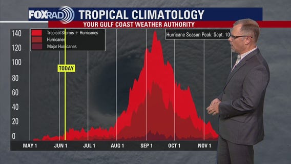
Another quiet day across the Atlantic Basin. The National Hurricane Center does not expect any tropical cyclones for the next several days.


Houston Weather: Hot now, but look out for severe storms late Saturday night
While most of today will be hot and dry, be on the lookout for strong to severe storms late tonight. Areas north have the highest likelihood of seeing large hail, and damaging winds mainly between 7 p.m. - midnight. Next week is all about the heat, and while we'll approach records toward the end at least there will be plenty of wind and solar energy to help the grid! Feels like values will be 5-10 degrees above actual temperatures, so practicing heat safety will be imperative.


Houston-weather: The heat is on! Very hot weather in the weekend forecast, storms possible Saturday night
Storms across North Texas may creep into Southeast Texas late on Saturday. Most of the day will be dry and hot but keep an eye to the north of Houston as the sun starts to set. The weekend ends warm and dry as we shift to a pattern that will bring very hot temperatures. Be safe with your outdoor activities at the end of the week.

Tropical Weather Forecast - June 8, 2023
Things are quiet for now in the Atlantic Basin but there are some specific areas to watch during the month of June for possible tropical cyclone formation.


Houston Weather: Late day thunderstorms for Saturday with temperatures expected to rise Monday
Late day thunderstorms are expected for Saturday. By Monday temperatures are expected to rise likely near triple digits. Lena Maria also talks to us about lightning safety.


Houston weather: Severe thunderstorms expected for Saturday
Lena Maria shares Houston's daily forecast. Severe storms expected for Saturday.


Canadian wildfire causing smoky conditions for the fourth day
The Northeastern region of the United States are preparing for a fourth day of smoky and dangerous air from the Canadian wildfires.


Preparing for summer heat; what you should know
Triple digital temperatures are returning to the Houston-area in the coming days.


Severe thunderstorms rolled through Houston Thursday; less severe storms expected for Friday
Another hot and hazy day, with quiet conditions and sunshine to start and a few isolated downpours or rumbles of thunder later this afternoon. While much less coverage and intensity of storms is expected today, Saturday evening could get rowdy again if storms approaching from the north hold together. They may dissipate upon approach, and past that rain chances dwindle as a heat dome builds. Triple digit feels like values will begin this weekend, so take breaks often in the shade and stay hydrated if spending extended periods of time outdoors especially during peak heating of the day. Don't forget about your furry friends as well, and LOOK before you LOCK.


Lightning strikes a Houston apartment complex causing a large fire
Severe storms rolled through Houston Thursday evening. Lightning struck an apartment complex causing a large fire, displacing residents.


VIDEOS: Houston severe weather causes damage, fallen trees in neighborhoods
Multiple videos show how the Houston area was impacted by severe thunderstorms rolling into neighborhoods and surrounding counties on Thursday.


Houston weather: Flash Flood, Thunderstorm Warning issued; more than 200,000 report outages
More than 200,000 power outages were reported across Houston as severe storms continue to pour down in Harris and surrounding counties.


Houston weather: Thunderstorm Warning for parts of Harris County, few severe storms
Strong to severe storms are possible across all of SE TX through early tonight as a disturbance moves through. Large hail, heavy rain, frequent lightning & damaging winds are all possible through about 10 PM. Storms will be dropping SE towards the coast and could get feisty. Make sure to stay alert & download our FOX 26 WX App to keep track of the threatening weather. A pattern shift is still scheduled for the weekend and much of next week with hotter and drier weather returning. We will be flirting with triple digits next week with some parts of SE TX close to heat advisory criteria by the middle and end of next week!


Tropical Weather Forecast - June 8, 2023
Tropical Weather Forecast


Dangerous air quality smothers major cities as Canada wildfires push smoke into US
The wildfire smoke has prompted air quality alerts from the Midwest to the Northeast and down to the mid-Atlantic and Carolinas.


Mars or Manhattan? Wildfire smoke draws comparisons to Red Planet
The light-scattering effect of the smoke molecules turned the sky several shades of red throughout the day Wednesday and had some asking, am I on Mars or Earth?