


Houston weather: Hot, dry 4th of July Weekend
Hot and dry 4th of July Weekend expected


FOX 26 Houston Weather Forecast
Today will mark the 22nd day in a row of above average temperatures with very few changes compared with each day earlier this week. The high pressure "heat dome" will retreat to the east over the next few days, so slowly but surely our weather will return to normal with mid 90s next week along with scattered showers for the 4th of July.


FOX 26 Houston Weather Forecast
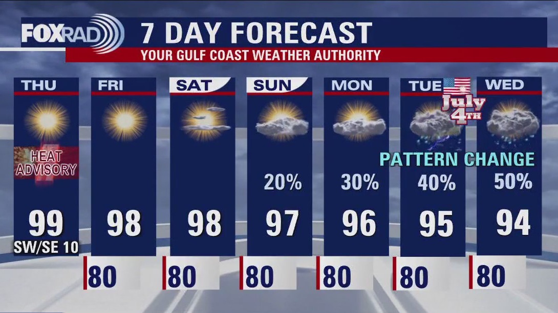
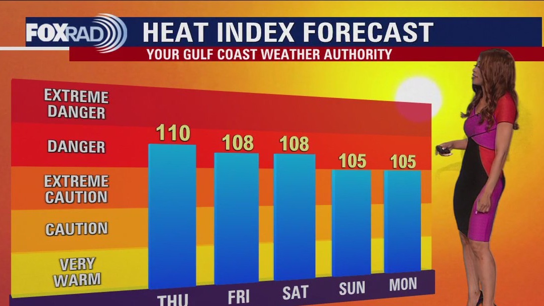
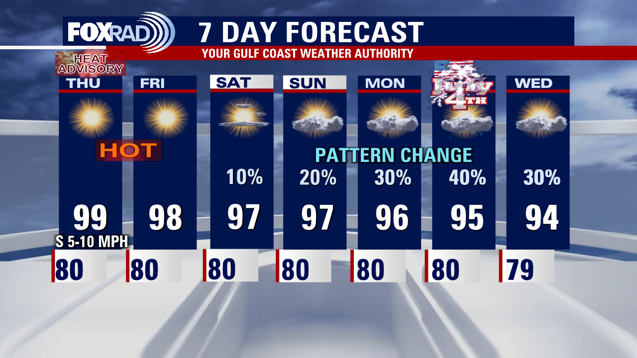
HEAT ADVISORY has been extended until 7 PM Friday with heat index values expected to climb to around 105 - 110. Actual temperatures are likely climbing to the upper 90s Friday and again on Saturday. There will however be a gradual shift to a more unsettled weather pattern that will include less heat, more clouds and more rain. Isolated showers and storms return by Sunday afternoon with better chances for scattered storms on Monday and the Fourth of July on Tuesday. Best chance for storms on the Fourth of July will be from 1PM - 7PM. Make sure to head indoors if you hear thunder or see lightning! A few heavy downpours may also impact your holiday outdoor plans. Unsettled weather continues with more rain and storms Wednesday and Thursday with temperatures in the low to middle 90s.


Some Houston-area roadways buckling from recent extreme heat
The scorching heatwave sweeping across Texas has taken its toll on Houston-area roadways, causing multiple instances of buckling and breakage.

FOX 26 Houston Weather Forecast
HEAT ADVISORY has been extended until 7 PM Friday with heat index values expected to climb to around 105 - 110. Actual temperatures are likely climbing to the upper 90s Friday and again on Saturday. There will however be a gradual shift to a more unsettled weather pattern that will include less heat, more clouds, and more rain. Isolated showers and storms return by Sunday afternoon with better chances for scattered storms on Monday and the Fourth of July on Tuesday. The best chance for storms on the Fourth of July will be from 1 - 7 p.m. Make sure to head indoors if you hear thunder or see lightning! A few heavy downpours may also impact your holiday outdoor plans. Unsettled weather continues with more rain and storms Wednesday and Thursday with temperatures in the low to middle 90s.


How to survive getting caught in rip current, according to NWS
The National Weather Service provides a video to visualize what you should do if you end up caught in a rip current while out on the beach.


Tropical Weather Forecast - June 29, 2023
There's a disturbance in the SW Atlantic that has a very low chance for tropical cyclone development over the next 2-7 days as it gets closer to Bermuda. In the eastern Pacific, it's very active with newly formed Tropical Storm Beatriz near SW Mexico & Hurricane Adrian. The Gulf of Mexico & Caribbean remain quiet for now.


El Tiempo 29 de Junio de 2023
#FOX26 Meteor?loga Lena Maria Arango tiene su pron?stico para el fin de semana.

FOX 26 Houston Weather Forecast
Live & breaking news for the We are still looking at a couple more days worth of heat alerts through at least the start of the weekend before we start to notice the pattern shift that will take place for most of next week. Hot, dry days linger through Saturday and by Sunday cloud cover increases with a few isolated light showers through Monday. Unfortunately, for the July 4th holiday locally scattered showers and storms will be in the mix. In fact, much of next week looks on and off unsettled. The good news is, it comes with a decline in temperatures, and daytime highs will be much more reasonable, closer to our average for this time of year in the low-mid 90s. entire Houston area.


Houston weather: Heat advisory in effect until 7 p.m.
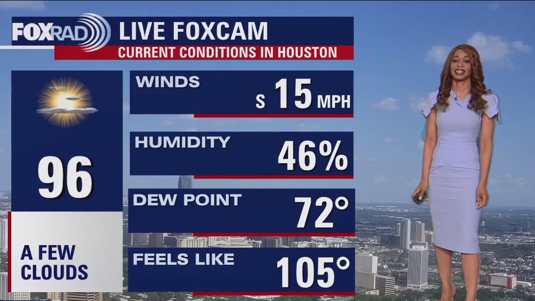
We are on day 21 of above normal high temperatures and another day with a heat advisory in effect.


ERCOT Board votes for pay raises
The ERCOT Board of Directors has voted to give themselves pay raises. FOX 26's Lina De Florias explains.

FOX 26 Houston Weather Forecast
We are on day 21 of above normal high temperatures and another day with a heat advisory in effect. We'll stay very warm through the weekend, but as high pressure shifts to our east and weakens, it should allow temps to return to normal by the Fourth of July with scattered showers and storms possible.


How is air quality measured?
As smoky air from Canada’s wildfires shrouds broad swaths of the U.S., here are seven facts you should know about measuring air quality.

FOX 26 Houston Weather Forecast
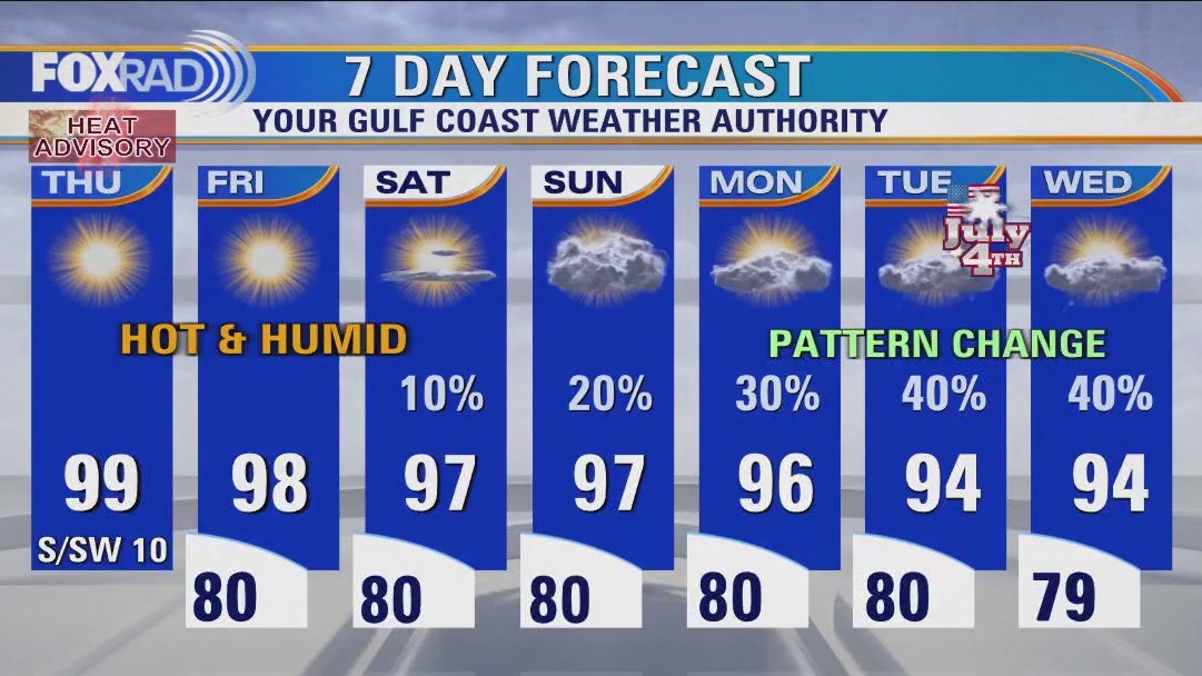
Heat Dome remains parked over Texas and that means more hot and dry weather. HEAT ADVISORY remains in effect until 7 PM Thursday for Heat Index values of 105-112 possible. The heat dome will keep sliding east this weekend and next week allowing for a few changes. Low rain chances return to the area this weekend with more clouds and a better shot for spotty rain and storms next week. Temperatures will also be closer to average next week in the middle 90s instead of around triple digits. Still practice heat safety and take it easy in the sizzling temps! Drink lots of water, limit time outside during hottest part of the day, take breaks in the shade while outside and double check your car for kids or pets before you walk away. Scattered showers are expected for the Fourth of July holiday Tuesday but it should not be a washout. Download our FOX 26 Weather App for all of the latest information on the heat and the tropics!


Spring residents still cleaning storm damage days later during heatwave
It's been weeks since a storm destroyed so many homes in the northern parts of our viewing area, leaving residents without power in this heat and many without a place to stay.

Heat advisory continues, low rain chances return
Heat Dome remains parked over Texas and that means more hot and dry weather. HEAT ADVISORY remains in effect until 7 PM Thursday for Heat Index values of 105-112 possible. The heat dome will keep sliding east this weekend and next week allowing for a few changes. Low rain chances return to the area this weekend with more clouds and a better shot for spotty rain and storms next week. Temperatures will also be closer to average next week in the middle 90s instead of around triple digits. Still, practice heat safety and take it easy in the sizzling temps! Drink lots of water, limit time outside during the hottest part of the day, take breaks in the shade while outside, and double-check your car for kids or pets before you walk away. Scattered showers are expected for the Fourth of July holiday Tuesday but it should not be a washout. Download our FOX 26 Weather App for all of the latest information on the heat and the tropics!


Triple-digit heatwave puts strain on Houston-area restaurants
Houston’s heat wave is doing a number on local restaurants. FOX 26’s Damali Keith from shares how Houston-area owners are getting creative to stay open.


US residents impacted by Canada wildfires
Millions of Americans are dealing with unhealthy air for another day as a result of wildfires in Canada.


Storm cleanup slow in Spring, residents say
It's been weeks since a storm destroyed so many homes in the northern parts of our viewing area, leaving residents without power in this heat and many without a place to stay.


Triple-digit heat puts strain on Houston restaurants
Houston?s heat wave is doing a number on local restaurants. FOX 26?s Damali Keith from one ...as area owners get creative in an effort to stay open.