


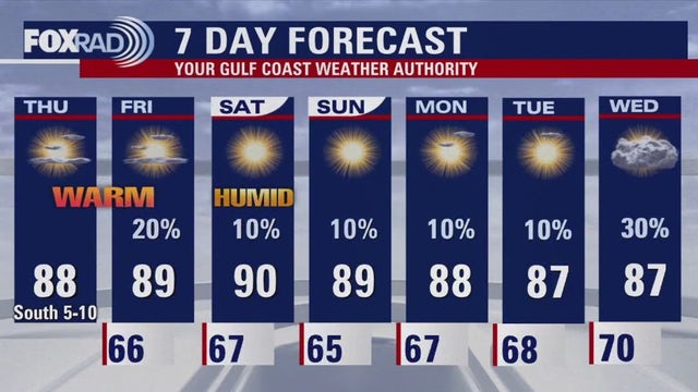
FOX 26 Houston Weather Forecast | Warm weekend ahead
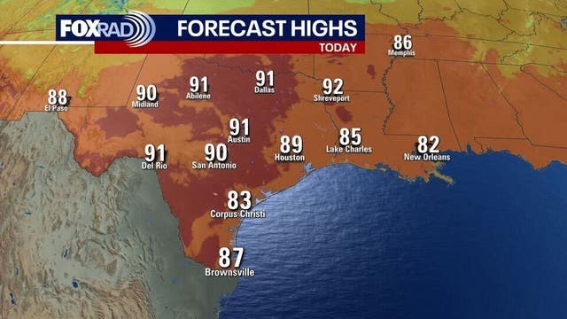
Record heat was the big story on Friday with a new record high being set for Bush Airport in Houston of 92 degrees. Previous record high was 91 set back in 1950 and 2021. Temperatures will remain nearly 10 degrees above average this weekend near 90 with little to no rain. We stay stuck in this pattern through early next week. There are signs of a pattern change by next Wednesday and Thursday as rain chances finally increase a bit and we shave a few degrees off afternoon high temperatures. Models are indicating a tropical system could form in the SW Caribbean by the middle of next week where water temperatures are still super warm. This likely would NOT head to Texas but could bring some heavy rain and flood potential to some of the Caribbean Islands and Florida. Have a great weekend and make sure to download FOX Local on your smart tv or your phone for weather where you live!
Record heat was the big story on Friday with a new record high being set for Bush Airport in Houston of 92 degrees. Previous record high was 91 set back in 1950 and 2021. Temperatures will remain nearly 10 degrees above average this weekend near 90 with little to no rain. We stay stuck in this pattern through early next week. There are signs of a pattern change by next Wednesday and Thursday as rain chances finally increase a bit and we shave a few degrees off afternoon high temperatures. Models are indicating a tropical system could form in the SW Caribbean by the middle of next week where water temperatures are still super warm. This likely would NOT head to Texas but could bring some heavy rain and flood potential to some of the Caribbean Islands and Florida. Have a great weekend and make sure to download FOX Local on your smart tv or your phone for weather where you live!

FOX 26 Houston Weather Forecast
Record heat was the big story today with a new record high being set for Bush Airport in Houston of 92 degrees. Previous record high was 91 set back in 1950 and 2021. Temperatures will remain nearly 10 degrees advice average this weekend near 90 with little to no rain. We stay stuck in this Peterborough thrive early next week. There are signs of a pattern change by next Wednesday and Thursday as rain chances finally increase a bit and we shave a few degrees off afternoon high temperatures. Models are indicating a tropical system could form in the SW Caribbean by the middle of next week where water temperatures are still super warm. This likely would NOT head to Texas but could bring some heavy rain and flood potential to some of the Caribbean Islands and Florida. Have a great weekend and make sure to download FOX Local on your smart tv or your phone for weather where you live!
Record heat was the big story today with a new record high being set for Bush Airport in Houston of 92 degrees. Previous record high was 91 set back in 1950 and 2021. Temperatures will remain nearly 10 degrees advice average this weekend near 90 with little to no rain. We stay stuck in this Peterborough thrive early next week. There are signs of a pattern change by next Wednesday and Thursday as rain chances finally increase a bit and we shave a few degrees off afternoon high temperatures. Models are indicating a tropical system could form in the SW Caribbean by the middle of next week where water temperatures are still super warm. This likely would NOT head to Texas but could bring some heavy rain and flood potential to some of the Caribbean Islands and Florida. Have a great weekend and make sure to download FOX Local on your smart tv or your phone for weather where you live!

Continuing to track Kristy, possible Caribbean development
In the Eastern Pacific, we are still tracking Hurricane Kristy. The good news is that Kristy is moving WNW away from the United States and Mexico and should remain over water. Also, Kristy is expected to run into more wind shear and this will allow Kristy to become a post-tropical system by Sunday. In the Atlantic basin, no tropical systems are expected to form through the weekend. However, models are indicating a tropical system could form in the SW Caribbean by the middle of next week where water temperatures are still super warm. This likely would NOT head to Texas but could bring some heavy rain and flood potential to some of the Caribbean Islands and Florida. Hurricane season runs through November 30.
In the Eastern Pacific, we are still tracking Hurricane Kristy. The good news is that Kristy is moving WNW away from the United States and Mexico and should remain over water. Also, Kristy is expected to run into more wind shear and this will allow Kristy to become a post-tropical system by Sunday. In the Atlantic basin, no tropical systems are expected to form through the weekend. However, models are indicating a tropical system could form in the SW Caribbean by the middle of next week where water temperatures are still super warm. This likely would NOT head to Texas but could bring some heavy rain and flood potential to some of the Caribbean Islands and Florida. Hurricane season runs through November 30.

Inspirational penguin and Fat Bear Week winner
Mike Iscovitz and Allison Gargaro sit to talk about a hurricane development in the Pacific, an inspirational penguin in Washington, and our Fat Bear Week winner!
Mike Iscovitz and Allison Gargaro sit to talk about a hurricane development in the Pacific, an inspirational penguin in Washington, and our Fat Bear Week winner!

Houston Halloween Forecast: An early look ahead
What will the Halloween forecast have in store for us? FOX 26 Meteorologist Allison Gargaro has an early look ahead so you can start planning your holiday.
What will the Halloween forecast have in store for us? FOX 26 Meteorologist Allison Gargaro has an early look ahead so you can start planning your holiday.

Houston Football Forecast : Oct. 25-27
The work week is wrapping up, and it's time for some football action. FOX 26's Remeisha Shade has the football forecast for this weekend.
The work week is wrapping up, and it's time for some football action. FOX 26's Remeisha Shade has the football forecast for this weekend.

FOX 26 Houston weather: Oct. 25 forecast
Patchy fog and not as cool this morning, then another sunny and warm day with highs near 90.
Patchy fog and not as cool this morning, then another sunny and warm day with highs near 90.

FOX 26 Houston Weather Forecast
Areas of thick fog could develop again across parts of SE Texas Friday morning. By the afternoon, temperatures will climb closer to 90 which is almost 10 degrees above normal. Rain chances remain very low through early next week with temperatures remaining toasty for late October. There are signs that rain chances may start to improve by the middle and end of next week which would mean a few showers possible for Thursday night trick-or-treating. Atlantic basin remains quiet for now but a tropical system could form mid-late next week in the Caribbean. Download FOX Local to get the latest weather where you live on your smart tv and now on your phone!
Areas of thick fog could develop again across parts of SE Texas Friday morning. By the afternoon, temperatures will climb closer to 90 which is almost 10 degrees above normal. Rain chances remain very low through early next week with temperatures remaining toasty for late October. There are signs that rain chances may start to improve by the middle and end of next week which would mean a few showers possible for Thursday night trick-or-treating. Atlantic basin remains quiet for now but a tropical system could form mid-late next week in the Caribbean. Download FOX Local to get the latest weather where you live on your smart tv and now on your phone!

Watching Kristy, possible development in Caribbean
The Atlantic basin remains quiet for now with no tropical cyclones expected to form over the next few days. However, models are indicating that there could be some tropical development in the western or Central Caribbean mid-late next week. In the Eastern Pacific, Hurricane Kristy is still a powerful Major hurricane tracking away from Mexico and the U.S. Kristy should run into more wind shear, cooler & drier air by this weekend & early next week. This will cause the system to lose tropical characteristics and weaken.
The Atlantic basin remains quiet for now with no tropical cyclones expected to form over the next few days. However, models are indicating that there could be some tropical development in the western or Central Caribbean mid-late next week. In the Eastern Pacific, Hurricane Kristy is still a powerful Major hurricane tracking away from Mexico and the U.S. Kristy should run into more wind shear, cooler & drier air by this weekend & early next week. This will cause the system to lose tropical characteristics and weaken.
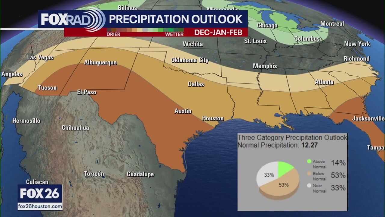
What to expect this winter | Forecasting With Friends
Today on Forecasting with Friends we take a look at the warm weather across the Houston area, the damage left behind by Helene, what you need to know about portable generators and Lance Wood from the NWS on what to expect this winter.
Today on Forecasting with Friends we take a look at the warm weather across the Houston area, the damage left behind by Helene, what you need to know about portable generators and Lance Wood from the NWS on what to expect this winter.


Hurricane Helene forces North Carolina residents to sleep in tents where homes once stood
Nearly a month after Hurricane Helene struck western North Carolina, locals are sleeping in tents where homes once stood, and volunteers from across the U.S. are helping.
Nearly a month after Hurricane Helene struck western North Carolina, locals are sleeping in tents where homes once stood, and volunteers from across the U.S. are helping.

Houston weather forecast for Thursday, October 24
Houston weather forecast for Thursday, October 24.
Houston weather forecast for Thursday, October 24.

FOX 26 Houston weather: Oct. 24 forecast
Patchy morning fog, then mostly sunny and warm with highs in the mid to upper 80s.
Patchy morning fog, then mostly sunny and warm with highs in the mid to upper 80s.

FOX 26 Houston Weather Forecast
Air Quality Alert for higher ozone levels has been extended until Thursday evening. Reduce time outside if you are irritated by these conditions. Otherwise, it's more of the same for the rest of this week with near record heat and extremely low rain chances. High temperatures will remain near 90. Areas of thick fog could impact your early voting in the morning and toasty temperatures will be the main issue in the afternoon. Models are indicating that we may finally break out of this super dry weather pattern by the end of October and early November. Get details on weather where you live by downloading FOX Local on your smart TV and now also on your phone!
Air Quality Alert for higher ozone levels has been extended until Thursday evening. Reduce time outside if you are irritated by these conditions. Otherwise, it's more of the same for the rest of this week with near record heat and extremely low rain chances. High temperatures will remain near 90. Areas of thick fog could impact your early voting in the morning and toasty temperatures will be the main issue in the afternoon. Models are indicating that we may finally break out of this super dry weather pattern by the end of October and early November. Get details on weather where you live by downloading FOX Local on your smart TV and now also on your phone!

FOX 26 Houston Weather Forecast
Air Quality Alert for higher ozone levels has been extended until Thursday evening. Reduce time outside if you are irritated by these conditions. Otherwise, it's more of the same for the rest of this week with near record heat and extremely low rain chances. High temperatures will remain near 90. Areas of thick fog could impact your early voting in the morning and toasty temperatures will be the main issue in the afternoon. Models are indicating that we may finally break out of this super dry weather pattern by the end of October and early November. Get details on weather where you live by downloading FOX Local on your smart tv and now also on your phone!
Air Quality Alert for higher ozone levels has been extended until Thursday evening. Reduce time outside if you are irritated by these conditions. Otherwise, it's more of the same for the rest of this week with near record heat and extremely low rain chances. High temperatures will remain near 90. Areas of thick fog could impact your early voting in the morning and toasty temperatures will be the main issue in the afternoon. Models are indicating that we may finally break out of this super dry weather pattern by the end of October and early November. Get details on weather where you live by downloading FOX Local on your smart tv and now also on your phone!

Possible development coming in western Caribbean? | FOX 26 Houston Tropical Weather Forecast
Oscar is no longer a tropical system but is still bringing some heavy rain to Bermuda. Remnants of Oscar should push north of Bermuda Thursday and no additional tropical systems are expected in the Atlantic basin over the next 7 days. However, models are hinting that there could be some potential development in the western Caribbean about 10 days out. That would be around early November, so keep checking back for updates! Kristy has blown up to a small but powerful major hurricane in the eastern Pacific but is moving away from land.
Oscar is no longer a tropical system but is still bringing some heavy rain to Bermuda. Remnants of Oscar should push north of Bermuda Thursday and no additional tropical systems are expected in the Atlantic basin over the next 7 days. However, models are hinting that there could be some potential development in the western Caribbean about 10 days out. That would be around early November, so keep checking back for updates! Kristy has blown up to a small but powerful major hurricane in the eastern Pacific but is moving away from land.

Houston weather forecast for Wednesday, Oct. 23
Most areas have had no rain so far in October, and very little is expected over the next seven days.
Most areas have had no rain so far in October, and very little is expected over the next seven days.

FOX 26 Houston weather: Oct. 23 forecast
Patchy fog this morning, then mostly sunny and very warm with highs in the upper 80s.
Patchy fog this morning, then mostly sunny and very warm with highs in the upper 80s.

FOX 26 Houston weather: Oct. 22 morning forecast
SE Texas is waking up to patchy fog with temperatures in the 50s and 60s. Afternoon highs will reach the mid to upper 80s with a few passing clouds. Skies remain dry through the end of the month as our drought continues to worsen. Tropical Storm Oscar is bringing heavy rain and strong winds to the Bahamas today as it makes its way northeast into the Atlantic. This system will not be impacting the U.S.
SE Texas is waking up to patchy fog with temperatures in the 50s and 60s. Afternoon highs will reach the mid to upper 80s with a few passing clouds. Skies remain dry through the end of the month as our drought continues to worsen. Tropical Storm Oscar is bringing heavy rain and strong winds to the Bahamas today as it makes its way northeast into the Atlantic. This system will not be impacting the U.S.

FOX 26 Houston Weather Forecast
Weather for early voting and any other errands you may have planned should continue to be fairly quiet. Temperatures are heating up as we move farther away from the taste of fall weather we enjoyed last week with Houston dipping to the 40s! Look for highs near 90 the rest of this week with only a very slim 10% rain chance. Houston has moved back to moderate drought and this will likely get worse with no significant rain in sight. In the Atlantic basin, Tropical Storm Oscar is still sitting over eastern Cuba and will pass over the SE Bahamas over the next 24 hours. It is expected to turn NE and stay away from the U.S. Get all the weather info you want or need by downloading FOX Local, now for your phone AND smart TV! Download it today!
Weather for early voting and any other errands you may have planned should continue to be fairly quiet. Temperatures are heating up as we move farther away from the taste of fall weather we enjoyed last week with Houston dipping to the 40s! Look for highs near 90 the rest of this week with only a very slim 10% rain chance. Houston has moved back to moderate drought and this will likely get worse with no significant rain in sight. In the Atlantic basin, Tropical Storm Oscar is still sitting over eastern Cuba and will pass over the SE Bahamas over the next 24 hours. It is expected to turn NE and stay away from the U.S. Get all the weather info you want or need by downloading FOX Local, now for your phone AND smart TV! Download it today!