


Houston weather: Severe Thunderstorm, Flash Flood Warning for Harris County
A Severe Thunderstorm Warning is in effect for Harris, Liberty and Chambers counties until 9:30 a.m.
A Severe Thunderstorm Warning is in effect for Harris, Liberty and Chambers counties until 9:30 a.m.


Houston weather: Scattered, heavy rain for Monday with highs in 80s
Monday morning's heavy rain will move from the Sugar Land - Houston - Humble area to the coastal counties by late morning and midday.
Monday morning's heavy rain will move from the Sugar Land - Houston - Humble area to the coastal counties by late morning and midday.

Houston weather: Scattered showers Monday morning
The focus of Monday's heavy rain will move from the Sugar Land - Houston - Humble area to the coastal counties by late morning and midday. Models are showing improving conditions in the afternoon with highs in the low to mid 80s.
The focus of Monday's heavy rain will move from the Sugar Land - Houston - Humble area to the coastal counties by late morning and midday. Models are showing improving conditions in the afternoon with highs in the low to mid 80s.

Houston weather: Rainy days ahead
FOX 26 meteorologist John Dawson takes a look at the rain across the area and a look ahead at the rest of the week.
FOX 26 meteorologist John Dawson takes a look at the rain across the area and a look ahead at the rest of the week.


Houston weather radar: Sundays storms continue north overnight; unsettled pattern this week
A stalling front that brought some showers and downpours during the day on Easter Sunday will keep rain chances in the forecast for Sunday evening and throughout the day on Monday.
A stalling front that brought some showers and downpours during the day on Easter Sunday will keep rain chances in the forecast for Sunday evening and throughout the day on Monday.

Houston weather: Slight severe weather chances Sunday, followed by unsettled pattern
The highest chance for strong storms will be possible especially to the north of Houston. Beginning Monday, expect a mostly cloudy and humid pattern with a daily chance for showers or scattered storms through at least Friday.
The highest chance for strong storms will be possible especially to the north of Houston. Beginning Monday, expect a mostly cloudy and humid pattern with a daily chance for showers or scattered storms through at least Friday.
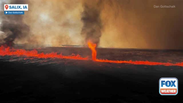

See it: 'Firenado' spins through burning Iowa field sparked by lightning
Strong thunderstorms in Iowa and Nebraska on Thursday night caused several lightning strikes in the area, one of which started this fire whirl.
Strong thunderstorms in Iowa and Nebraska on Thursday night caused several lightning strikes in the area, one of which started this fire whirl.

Houston weather: Your Easter Sunday morning forecast
The central Texas storm system should weaken as it heads toward Houston, but should still contribute to scattered showers that could put a damper on Easter morning.
The central Texas storm system should weaken as it heads toward Houston, but should still contribute to scattered showers that could put a damper on Easter morning.


Dallas weather: Cleanup begins after several reported tornados hit North Texas
Severe weather impacted parts of North Texas on Saturday night, with several tornadoes spotted, and damage reported in Parker County, Jack County, Montague County, and Hood County.
Severe weather impacted parts of North Texas on Saturday night, with several tornadoes spotted, and damage reported in Parker County, Jack County, Montague County, and Hood County.

Houston weather: April 19 overnight forecast
Fox 26 meteorologist John Dawson is tracking showers on Easter morning and the possibility of storms Sunday afternoon.
Fox 26 meteorologist John Dawson is tracking showers on Easter morning and the possibility of storms Sunday afternoon.


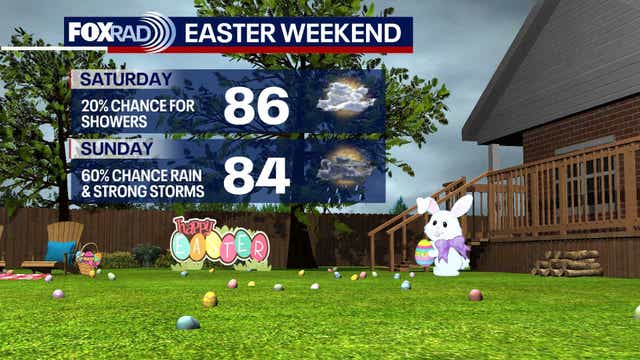
Houston weather: Easter weekend forecast
Weather could have an impact on your Easter weekend plans. Here's a look at our forecast.
Weather could have an impact on your Easter weekend plans. Here's a look at our forecast.

Houston weather: Easter Sunday rain chances as of Saturday afternoon
Meteorologist John Dawson explains the slight chance of severe storms for the Greater Houston area.
Meteorologist John Dawson explains the slight chance of severe storms for the Greater Houston area.

Houston weather: Easter weekend forecast
FOX 26 meteorologist Allison Gargaro takes a look at the weather this weekend and the impact it may have on your Easter plans.
FOX 26 meteorologist Allison Gargaro takes a look at the weather this weekend and the impact it may have on your Easter plans.

Houston weather: Stormy Easter weekend possible across most of Texas
It's going to be windy and increasingly muggy tonight and Saturday as tough thunderstorms soak central and north Texas. Other than a few fast-moving showers on Saturday, the action will mostly stay to our west. So if you have travel plans to Austin, Waco, DFW or the Hill Country, just be aware that severe storms and heavy rain are a concern there.
It's going to be windy and increasingly muggy tonight and Saturday as tough thunderstorms soak central and north Texas. Other than a few fast-moving showers on Saturday, the action will mostly stay to our west. So if you have travel plans to Austin, Waco, DFW or the Hill Country, just be aware that severe storms and heavy rain are a concern there.

Houston weather: Severe weather chances for Easter weekend
FOX 26 meteorologist Remeisha Shade gives a Friday afternoon update on potential severe weather for Easter 2025 in the Greater Houston area.
FOX 26 meteorologist Remeisha Shade gives a Friday afternoon update on potential severe weather for Easter 2025 in the Greater Houston area.

Houston Easter Weekend Forecast
A storm system should weaken as it heads in our direction, but should still contribute to scattered showers that could put a damper on Easter morning. It won't rain everywhere, but scattered showers will probably move some Easter plans inside for a while. Later in the day, the chance for storms will increase, especially to the north of Houston, and a couple of strong ones are possible.
A storm system should weaken as it heads in our direction, but should still contribute to scattered showers that could put a damper on Easter morning. It won't rain everywhere, but scattered showers will probably move some Easter plans inside for a while. Later in the day, the chance for storms will increase, especially to the north of Houston, and a couple of strong ones are possible.

Australia animals, bulldog testimony, and more | Forecasting With Friends
It's Furry Friends Friday! FOX 26 meteorologists Mike Iscovitz and Allison Gargaro show their favorite animal stories from this week.
It's Furry Friends Friday! FOX 26 meteorologists Mike Iscovitz and Allison Gargaro show their favorite animal stories from this week.


Houston weather: Muggy Friday in the 80s; Easter Sunday rain chances
It's going to be windy and increasingly muggy for Friday with high expected to reach mid to upper 80s.
It's going to be windy and increasingly muggy for Friday with high expected to reach mid to upper 80s.

Houston weather: Muggy Friday in the 80s
It's going to be windy and increasingly muggy for Friday and Saturday as tough thunderstorms soak central and north Texas. The highs for today will reach mid to upper 80s.
It's going to be windy and increasingly muggy for Friday and Saturday as tough thunderstorms soak central and north Texas. The highs for today will reach mid to upper 80s.

Houston Weather: Humid Friday, stormy weekend
A south breeze has kicked in and will get stronger for Good Friday - wind gusts could exceed 30 mph on Friday along with very warm air and high humidity. Rain will remain sparse today and tomorrow with only a few showers possible. Severe storms will be possible in West and North Texas.
A south breeze has kicked in and will get stronger for Good Friday - wind gusts could exceed 30 mph on Friday along with very warm air and high humidity. Rain will remain sparse today and tomorrow with only a few showers possible. Severe storms will be possible in West and North Texas.