


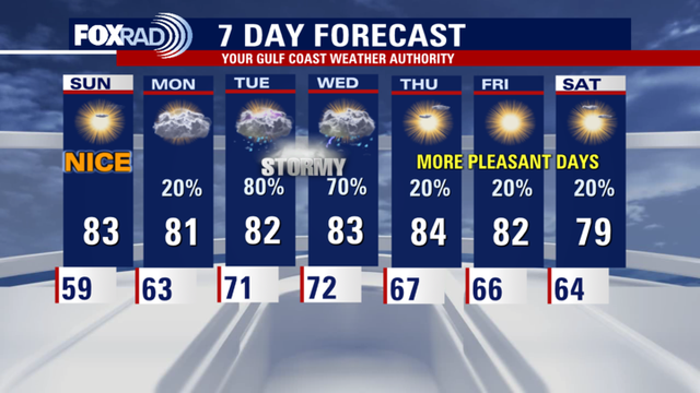
Houston weather: Evening showers possible Wednesday, spotty showers on Thursday
The heavy rainfall that moved across the Houston-area this week is slowly starting to move out with possible showers on Wednesday evening.
The heavy rainfall that moved across the Houston-area this week is slowly starting to move out with possible showers on Wednesday evening.

Heavy rainfall, lightening | Forecasting with Friends
Mike Iscovitz and Allison Gargaro talk heavy rain fall over the last 24 hours and lightening seen Wednesday morning. Also, JD talks with about climate and planting with Shel Winkley.
Mike Iscovitz and Allison Gargaro talk heavy rain fall over the last 24 hours and lightening seen Wednesday morning. Also, JD talks with about climate and planting with Shel Winkley.


Houston weather: Scattered rain possible, mostly warm Wednesday
Wednesday morning's storms move out of the Houston-area, though some isolated afternoon rain is possible. Temperature highs reach the low 80s.
Wednesday morning's storms move out of the Houston-area, though some isolated afternoon rain is possible. Temperature highs reach the low 80s.

Houston weather: Storms near the coast Wednesday
In coastal counties of the Houston-area showers and storms are possible this morning. It will be more isolated in the afternoon with highs in the low 80s.
In coastal counties of the Houston-area showers and storms are possible this morning. It will be more isolated in the afternoon with highs in the low 80s.

Houston weather: More rain possible on Wednesday
We will most likely see rain return to Galveston, Brazoria and surrounding areas through the day tomorrow with 2-3' of rain possible. Flooding risk and severe storm threat will continue through Wednesday evening. Isolated storms are possible elsewhere.
We will most likely see rain return to Galveston, Brazoria and surrounding areas through the day tomorrow with 2-3' of rain possible. Flooding risk and severe storm threat will continue through Wednesday evening. Isolated storms are possible elsewhere.


Houston weather: Tornado Watch ends for Tuesday, latest watches, warnings
The risk of heavy rain, hail, high winds, and a few tornadoes have made Tuesday a FOX 26 Storm Alert Day. A flood watch is in effect north of Houston throughout the day.
The risk of heavy rain, hail, high winds, and a few tornadoes have made Tuesday a FOX 26 Storm Alert Day. A flood watch is in effect north of Houston throughout the day.

Tornado Watch today | Forecasting With Friends
Join the FOX 26 Weather Team as we talk all things weather. We're keeping an eye on a tornado watch in our area.
Join the FOX 26 Weather Team as we talk all things weather. We're keeping an eye on a tornado watch in our area.

Houston weather: Severe storms possible Tuesday
Today is a FOX 26 Storm Alert Day and scattered severe storms are possible beginning midday through the afternoon. Otherwise, its warm and humid with highs in the low to mid 80s.
Today is a FOX 26 Storm Alert Day and scattered severe storms are possible beginning midday through the afternoon. Otherwise, its warm and humid with highs in the low to mid 80s.

Houston weather: Strong storms possible Tuesday, FOX 26 Storm Alert Day issued
Our entire area with a risk for severe weather on Tuesday. Tomorrow brings the threat for heavy storms, especially north of Houston with 4" of rain very likely. Spotty amounts of 3" will be possible closer to Houston and surrounding suburbs by afternoon and evening with some rain lingering on Wednesday.
Our entire area with a risk for severe weather on Tuesday. Tomorrow brings the threat for heavy storms, especially north of Houston with 4" of rain very likely. Spotty amounts of 3" will be possible closer to Houston and surrounding suburbs by afternoon and evening with some rain lingering on Wednesday.

Looking ahead to severe weather Tuesday
Mike Iscovitz takes a look at the upcoming severe weather expected to impact the Houston-area on Tuesday. Plus, Allison Gargaro has a count down until hurricane season.
Mike Iscovitz takes a look at the upcoming severe weather expected to impact the Houston-area on Tuesday. Plus, Allison Gargaro has a count down until hurricane season.


Houston weather: Severe weather possible on Tuesday, FOX 26 Alert Day issued
Expect some scattered rain later in the day on Monday as a severe weather threat is forecast for Tuesday. Temperature highs will reach near 80.
Expect some scattered rain later in the day on Monday as a severe weather threat is forecast for Tuesday. Temperature highs will reach near 80.

Houston weather: Cloudy, scattered rain for Monday
Clear and cool Monday morning, then mostly cloudy and breezy with late day rain. Temperatures to reach in the high 80s.
Clear and cool Monday morning, then mostly cloudy and breezy with late day rain. Temperatures to reach in the high 80s.

Houston weather: Your May 4 overnight forecast
The FOX 26 Weekend Team provides the latest local, regional, and national news events of the day.
The FOX 26 Weekend Team provides the latest local, regional, and national news events of the day.

Houston weather: Calm end to weekend; severe storm chances return this week
The beautiful weekend ends with a very pleasant evening across southeast Texas. A storm system will eventually impact Houston as it progresses across the state.
The beautiful weekend ends with a very pleasant evening across southeast Texas. A storm system will eventually impact Houston as it progresses across the state.


Houston weather: Calm Sunday night; Storm Alert Day on Tuesday
The beautiful weekend ends with a very pleasant evening across southeast Texas. A storm system will eventually impact Houston as it progresses across the state.
The beautiful weekend ends with a very pleasant evening across southeast Texas. A storm system will eventually impact Houston as it progresses across the state.

Houston weather: Your May 4 morning forecast
A beautiful day is expected for your Sunday, but some changes in the forecast are expected this week. FOX 26 Meteorologist Allison Gargaro has details.
A beautiful day is expected for your Sunday, but some changes in the forecast are expected this week. FOX 26 Meteorologist Allison Gargaro has details.

Houston weather: May 3 overnight forecast
FOX 26 meteorologist John Dawson takes a look at the rainy last few days and the storms that we can expect next week.
FOX 26 meteorologist John Dawson takes a look at the rainy last few days and the storms that we can expect next week.

Houston weather: Beautiful weekend continues, but more rain to come
After recent storms, we will have some great weather this weekend. Rain returns to our forecast next week.
After recent storms, we will have some great weather this weekend. Rain returns to our forecast next week.

Houston weather: Calm Sunday; storms return midweek
Sunday should be mainly dry. It looks like we have another round of stormy weather heading our way by the middle of next week.
Sunday should be mainly dry. It looks like we have another round of stormy weather heading our way by the middle of next week.