


Houston weather: Heat to remain across the area
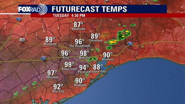
A front will move in to the area Tuesday afternoon and will bring a shift in our winds and should spark a few storms. The highest chance for stronger storms will be east and northeast of Houston, but an isolated storms is possible across the area.
A front will move in to the area Tuesday afternoon and will bring a shift in our winds and should spark a few storms. The highest chance for stronger storms will be east and northeast of Houston, but an isolated storms is possible across the area.

Heat risks during pregnancy | Forecasting with Friends
FOX 26 Meteorologist John Dawson talks with Shel Winkley from Climate Central about heat risks during pregnancy.
FOX 26 Meteorologist John Dawson talks with Shel Winkley from Climate Central about heat risks during pregnancy.


Watch: Lightning bolt blasts police cruiser
A lightning bolt struck a police cruiser in Oklahoma during a severe storm Monday night, a moment captured on surveillance video.
A lightning bolt struck a police cruiser in Oklahoma during a severe storm Monday night, a moment captured on surveillance video.

Houston weather: Hot Tuesday, isolated late-day storms possible
A front will move in to the area this afternoon and will bring a shift in our winds and should spark a few storms.
A front will move in to the area this afternoon and will bring a shift in our winds and should spark a few storms.

Houston weather forecast for May 20
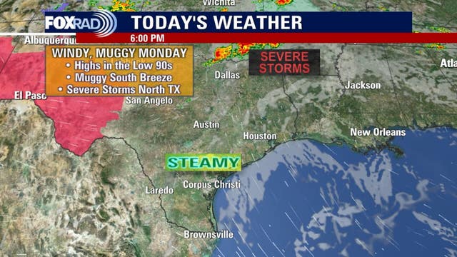
Hot again with near record highs. Isolated afternoon storms are possible. Highs in the mid 90s.
Hot again with near record highs. Isolated afternoon storms are possible. Highs in the mid 90s.

Houston weather: Another hot day on the way for Tuesday
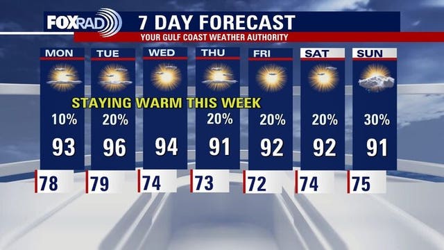
Our best chance of setting another record high will be Tuesday this week with a current record of 95 and an expected high temp of 97. Each day will be very warm for mid to late May, but humidity will vary a bit. A weak front will bring slightly lower humidity late Tuesday and Wednesday, so morning lows should feel a bit more comfortable. That being said, afternoons will remain hot.
Our best chance of setting another record high will be Tuesday this week with a current record of 95 and an expected high temp of 97. Each day will be very warm for mid to late May, but humidity will vary a bit. A weak front will bring slightly lower humidity late Tuesday and Wednesday, so morning lows should feel a bit more comfortable. That being said, afternoons will remain hot.

Houston weather: Heat to remain for most of the week
Our best chance of setting another record high will be Tuesday this week with a current record of 95 and an expected high temp of 97. Each day will be very warm for mid to late May, but humidity will vary a bit. A weak front will bring slightly lower humidity late Tuesday and Wednesday, so morning lows should feel a bit more comfortable. That being said, afternoons will remain hot.
Our best chance of setting another record high will be Tuesday this week with a current record of 95 and an expected high temp of 97. Each day will be very warm for mid to late May, but humidity will vary a bit. A weak front will bring slightly lower humidity late Tuesday and Wednesday, so morning lows should feel a bit more comfortable. That being said, afternoons will remain hot.

Heat, tornado outbreak and the upcoming hurricane season
FOX 26 Chief Meteorologist talks about the Houston heat, a deadly U.S. tornado outbreak and the upcoming Atlantic hurricane season.
FOX 26 Chief Meteorologist talks about the Houston heat, a deadly U.S. tornado outbreak and the upcoming Atlantic hurricane season.

Deadly severe weather outbreak across several states | Forecasting with Friends
The FOX 26 weather team has the latest on weather in Houston and around the country.
The FOX 26 weather team has the latest on weather in Houston and around the country.

Houston weather: Hot all week; slight chance for storm
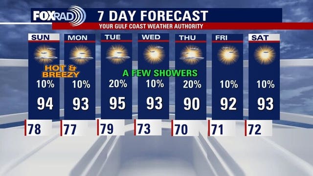
The Houston weather forecast for the week of May 19, 2025 includes more record or near-record heat and a chance for an isolated storm.
The Houston weather forecast for the week of May 19, 2025 includes more record or near-record heat and a chance for an isolated storm.

Devos Lightranger 800 Mini: Emergency Gear Test
You need a battery-powered light in your go-bag or emergency kit. Meteorologist John Dawson says a lantern for camping is a good option for a group or family. On today?s Emergency Gear Test he has one that is rechargeable and comes with its own tripod.
You need a battery-powered light in your go-bag or emergency kit. Meteorologist John Dawson says a lantern for camping is a good option for a group or family. On today?s Emergency Gear Test he has one that is rechargeable and comes with its own tripod.

Houston weather forecast for May 19
Breezy, hot and humid with a slight chance for a shower. Highs in the low to mid 90s.
Breezy, hot and humid with a slight chance for a shower. Highs in the low to mid 90s.

Houston weather: Your May 18 overnight forecast
The FOX 26 Weekend Team provides the latest local, regional, and national news events of the day.
The FOX 26 Weekend Team provides the latest local, regional, and national news events of the day.

Houston weather: Near record-high temps possible
While there's a slight drop in temps in comparison to last week, humidity will remain summer-like, and rain chances are low for the immediate Houston area.
While there's a slight drop in temps in comparison to last week, humidity will remain summer-like, and rain chances are low for the immediate Houston area.

Houston weather: Another warm week ahead
While there's a slight drop in temps in comparison to last week, humidity will remain summer-like, and rain chances are low for the immediate Houston area.
While there's a slight drop in temps in comparison to last week, humidity will remain summer-like, and rain chances are low for the immediate Houston area.

Kentucky recovering after deadly tornado outbreak
A tornado outbreak swept across the Ohio Valley Friday night, leaving at least 27 people dead.
A tornado outbreak swept across the Ohio Valley Friday night, leaving at least 27 people dead.

Houston weather: Your May 18 morning forecast
The very warm and humid trend will continue, but there will be some relief. FOX 16 Houston Meteorologist Allison Gargaro has your forecast.
The very warm and humid trend will continue, but there will be some relief. FOX 16 Houston Meteorologist Allison Gargaro has your forecast.

Houston weather: May 17 overnight forecast
FOX 26 meteorologist John Dawson takes a look at the possibility of near-records heat to start the week.
FOX 26 meteorologist John Dawson takes a look at the possibility of near-records heat to start the week.

Houston weather: Temps near record highs this weekend
The summer-like heat has come early this year. Some daily high temperature records could be broken this weekend through early next week.
The summer-like heat has come early this year. Some daily high temperature records could be broken this weekend through early next week.

Houston weather: Heat wave continues this upcoming week
Some daily high temperature records could be broken this weekend through early next week.
Some daily high temperature records could be broken this weekend through early next week.