

Thursday evening forecast
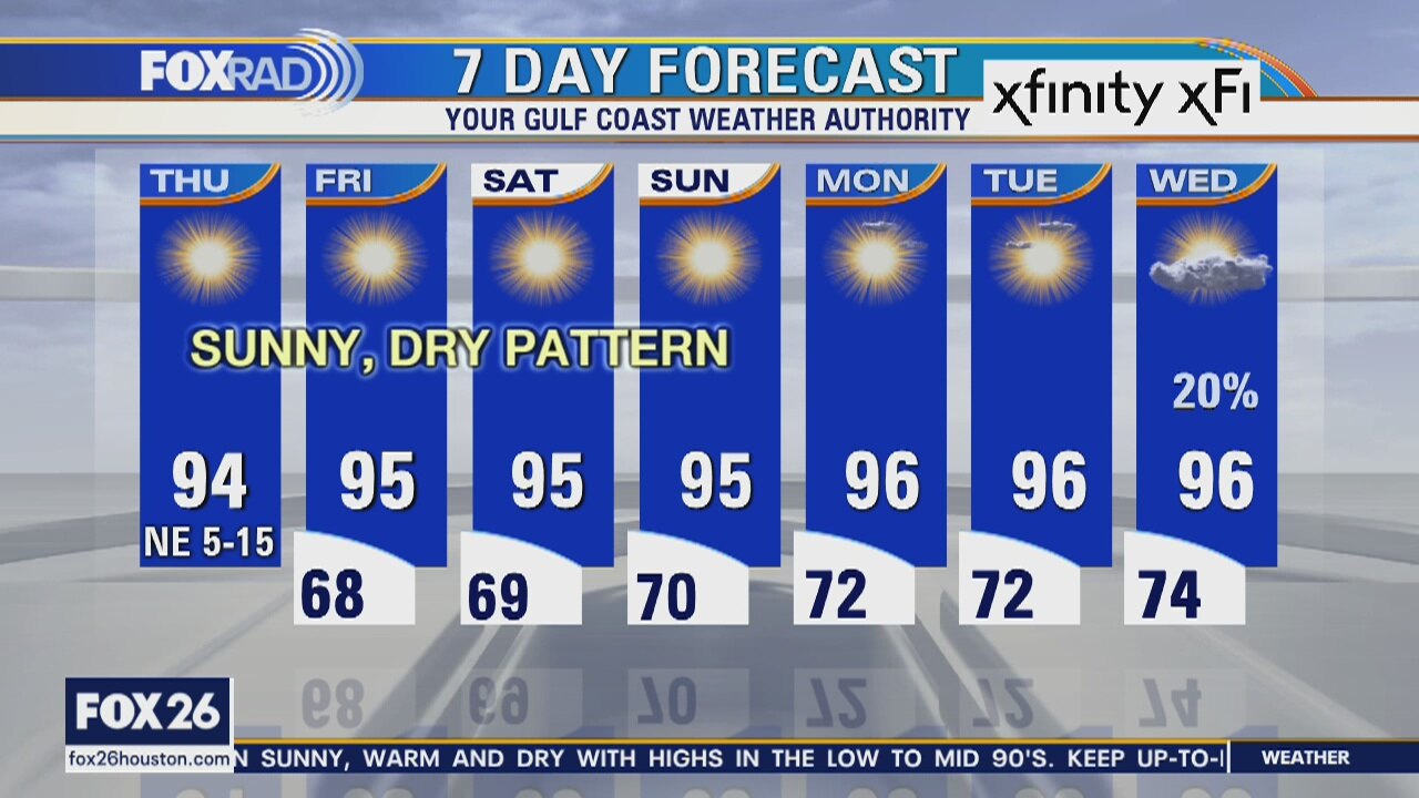
We are in a very stable weather pattern over the next few days. The air remains less humid and we can really feel a difference. The humidity will start to return over the weekend, but it still looks rather dry for now with highs in the 90s.
We are in a very stable weather pattern over the next few days. The air remains less humid and we can really feel a difference. The humidity will start to return over the weekend, but it still looks rather dry for now with highs in the 90s.
Thursday morning weather forecast
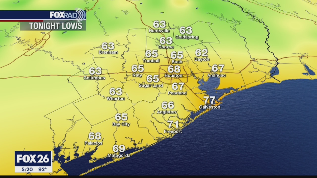
Our weather for the next several days will be sunny and dry with lows in the 60s and low 70s and highs in the 90s. With very low humidity for this time of the year, there won?t be much of a heat index, but there will be strong sunshine.
Our weather for the next several days will be sunny and dry with lows in the 60s and low 70s and highs in the 90s. With very low humidity for this time of the year, there won?t be much of a heat index, but there will be strong sunshine.
Thursday Morning Weather Forecast
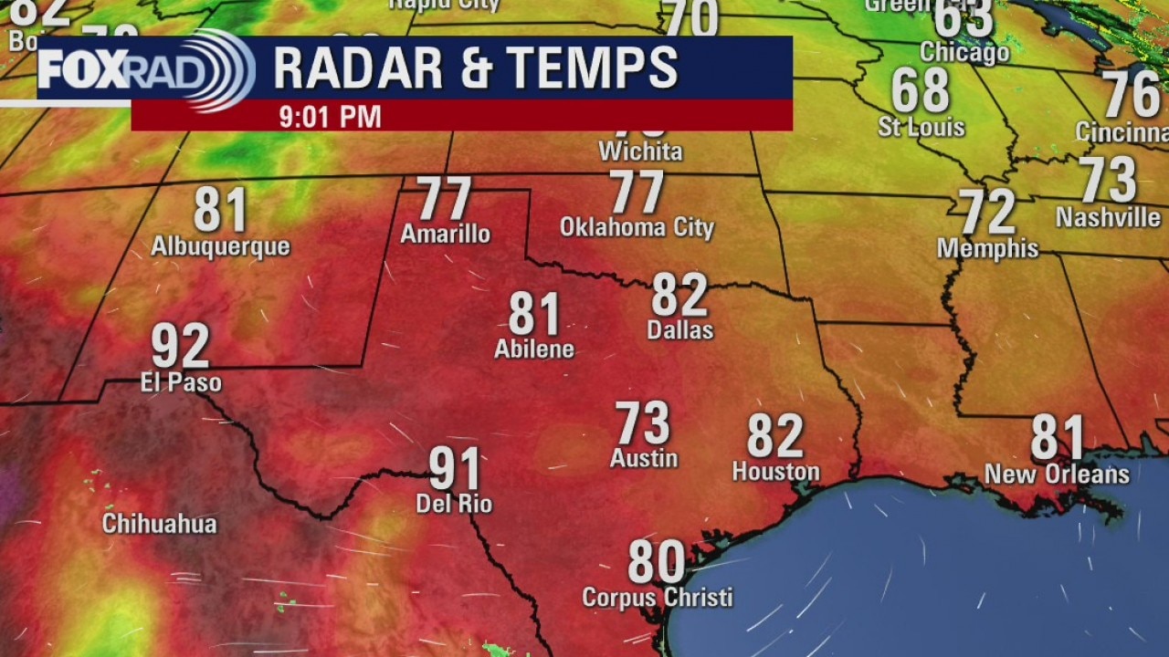
The weather will be clear and dry for the next few days thanks to high pressure NW of the Houston area. Lows in the 60s on both Thur and Fri are a bonus. Less humid air in June is a wonderful thing and it won?t last very long.
The weather will be clear and dry for the next few days thanks to high pressure NW of the Houston area. Lows in the 60s on both Thur and Fri are a bonus. Less humid air in June is a wonderful thing and it won?t last very long.
Wednesday Evening Weather Forecast
The weather will be clear and dry for the next few days thanks to high pressure NW of the Houston area. Lows in the 60s on both Thur and Fri are a bonus. Less humid air in June is a wonderful thing and it won?t last very long.
The weather will be clear and dry for the next few days thanks to high pressure NW of the Houston area. Lows in the 60s on both Thur and Fri are a bonus. Less humid air in June is a wonderful thing and it won?t last very long.
Wednesday weather forecast
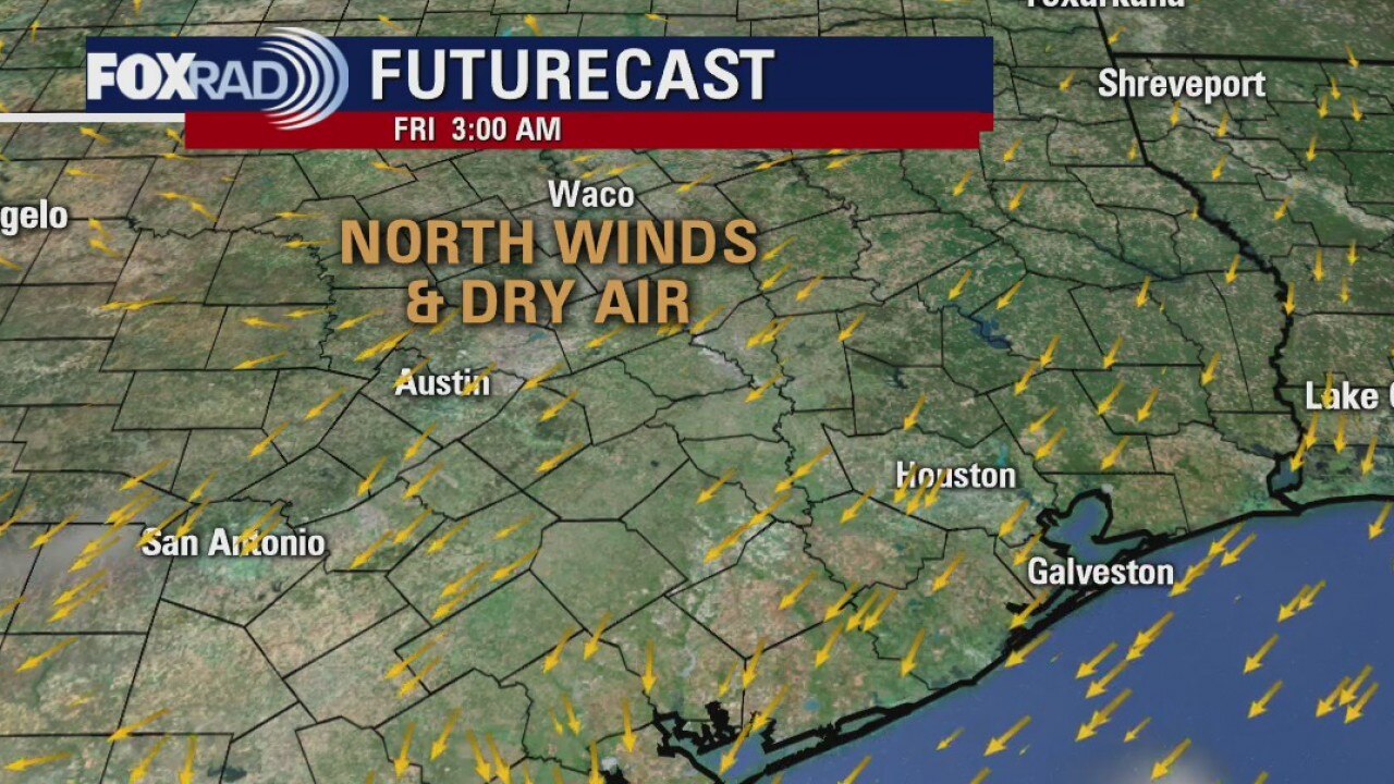
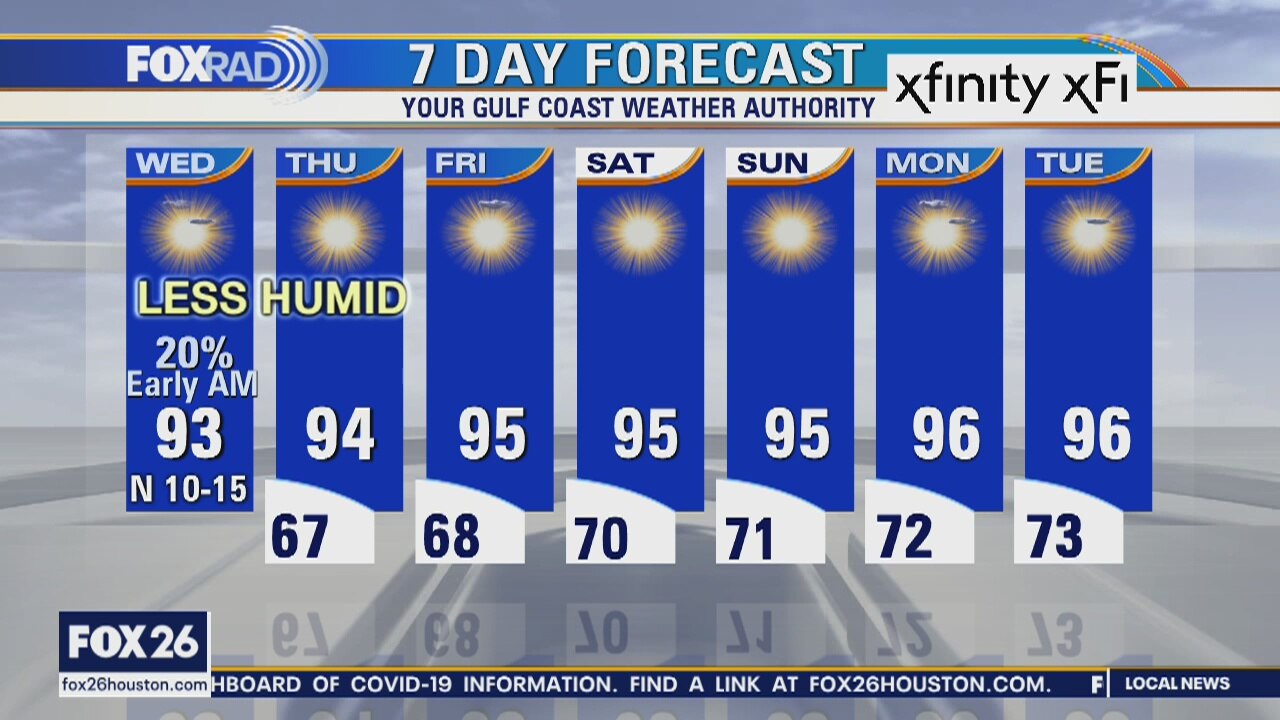
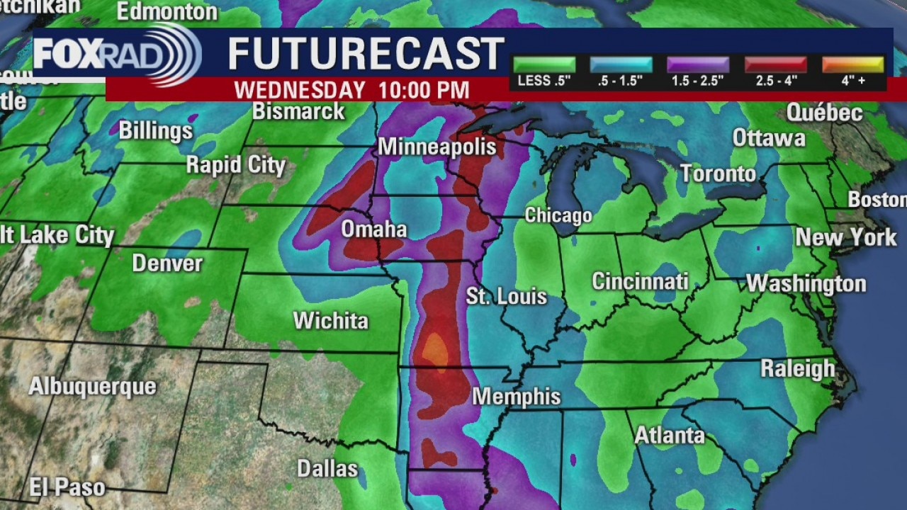
A cold front brought a brief round of storms early today and much drier north breezes have kicked in. This means that the next few days will feature much lower humidity. Look for sunny and very warm, dry afternoons and more comfortable weather during the evenings and overnight. Lows could drop into the 60s for the next two or three days.
A cold front brought a brief round of storms early today and much drier north breezes have kicked in. This means that the next few days will feature much lower humidity. Look for sunny and very warm, dry afternoons and more comfortable weather during the evenings and overnight. Lows could drop into the 60s for the next two or three days.
Wednesday morning forecast
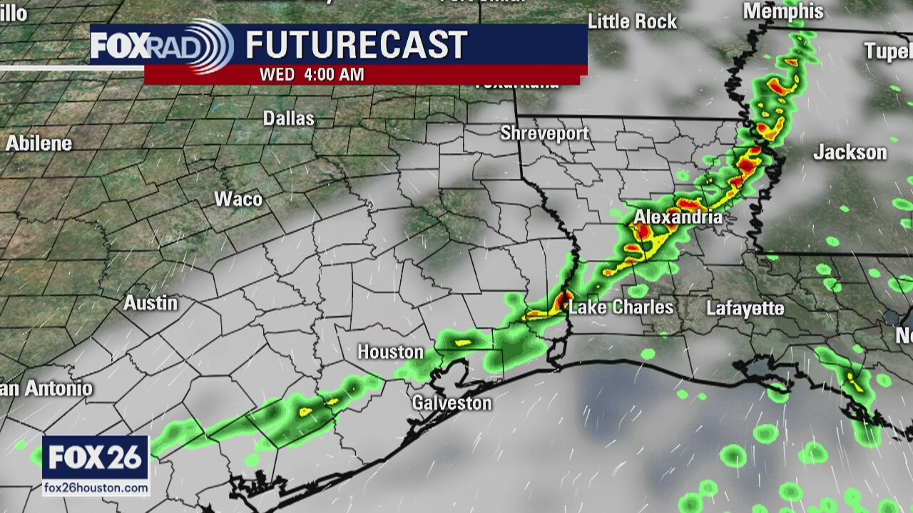
There may be a quick shower very early Wednesday morning as a weak front approaches Texas. It will usher in slightly drier air over the next few days. Temperatures will only be a few degrees cooler, but it will feel cooler with less mugginess. The rest of the week looks mostly sunny and dry.
There may be a quick shower very early Wednesday morning as a weak front approaches Texas. It will usher in slightly drier air over the next few days. Temperatures will only be a few degrees cooler, but it will feel cooler with less mugginess. The rest of the week looks mostly sunny and dry.
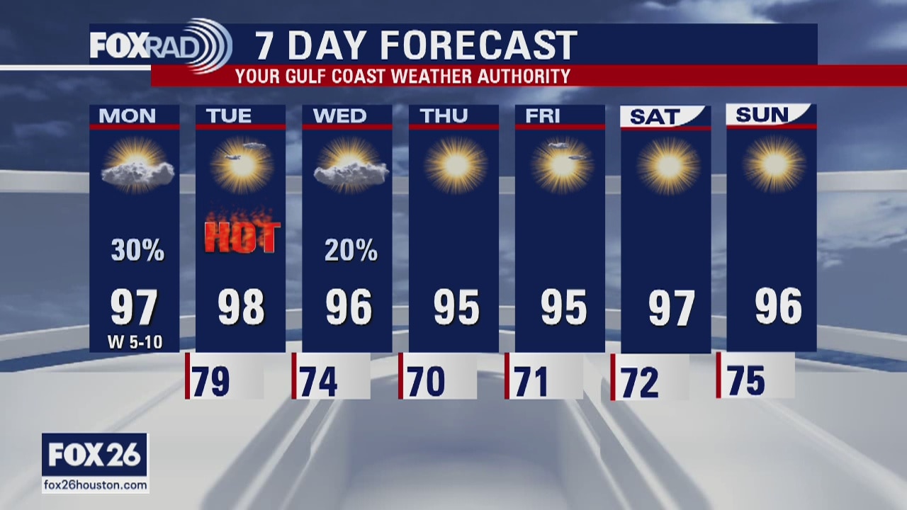
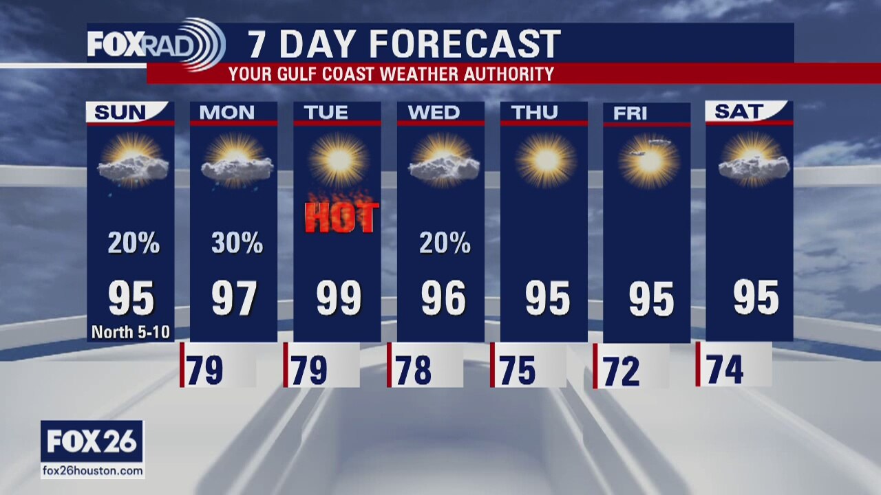
Tuesday weather forecast
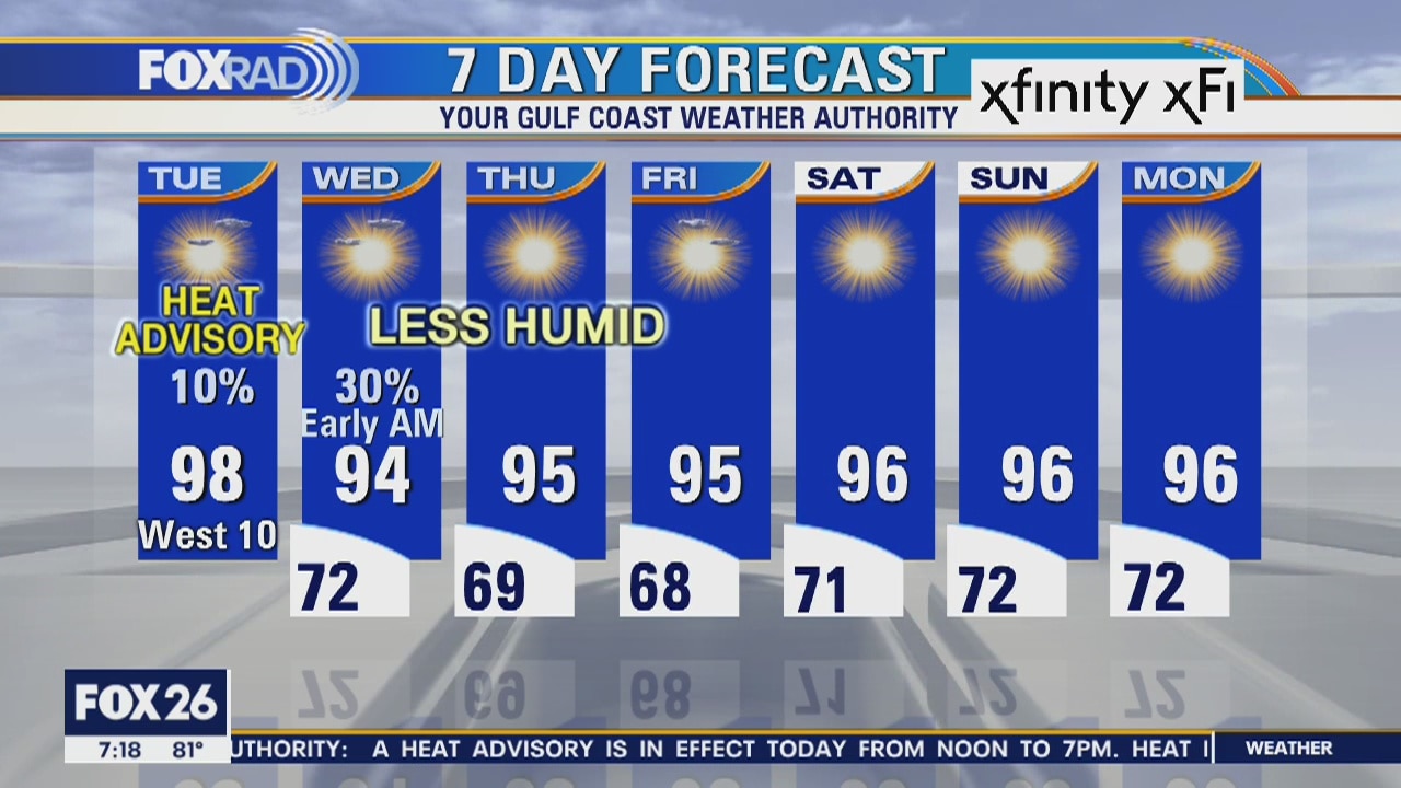
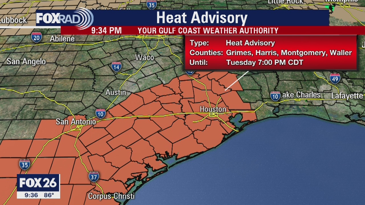
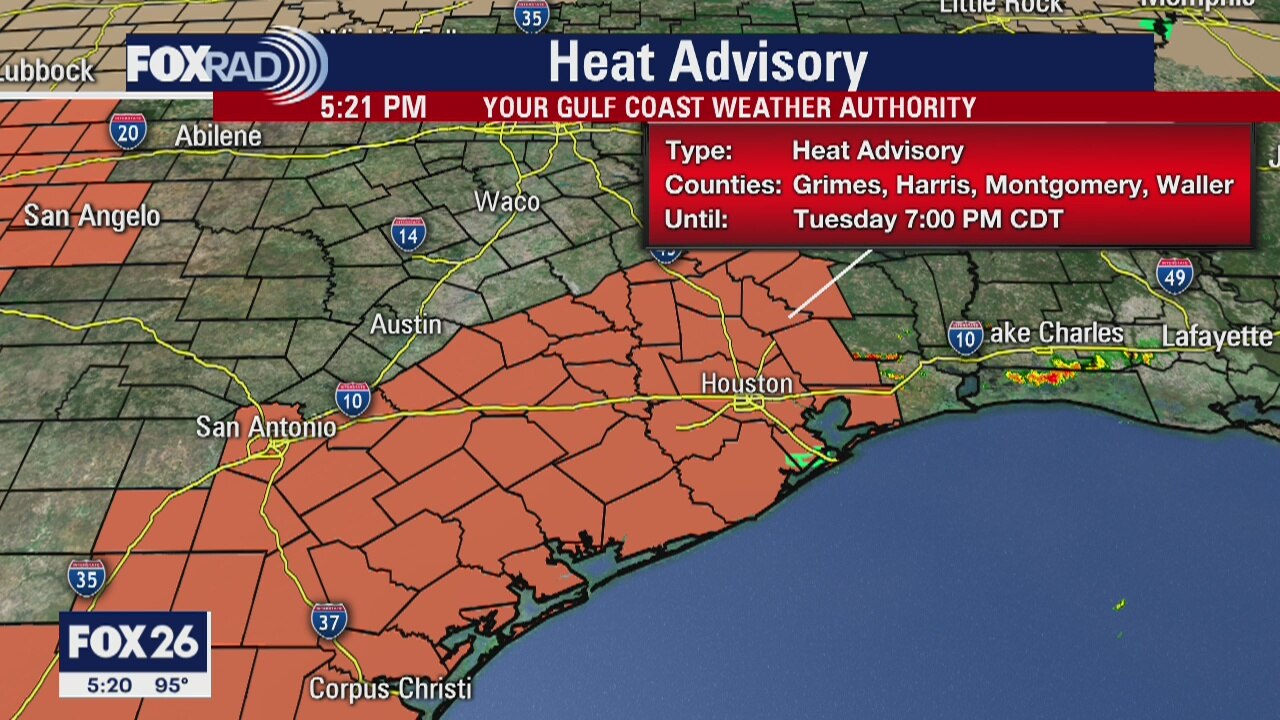
Today is likely to be the hottest day since last October as highs rise into the mid and upper 90s. A heat advisory is in effect from noon to 7 pm and the heat index could exceed 110. A front will move through early Wednesday that will bring a brief round of rain followed by much drier air for the rest of the week.
Today is likely to be the hottest day since last October as highs rise into the mid and upper 90s. A heat advisory is in effect from noon to 7 pm and the heat index could exceed 110. A front will move through early Wednesday that will bring a brief round of rain followed by much drier air for the rest of the week.
Tuesday morning forecast
It?s a hot and dry forecast for the week ahead. A Heat Advisory is already in effect for southeast Texas on Tuesday, and we can count on it again for Wednesday. It will feel up to 111, and that is dangerously hot. If you are outside for extended periods, stay cool any way you can.
It?s a hot and dry forecast for the week ahead. A Heat Advisory is already in effect for southeast Texas on Tuesday, and we can count on it again for Wednesday. It will feel up to 111, and that is dangerously hot. If you are outside for extended periods, stay cool any way you can.
Monday Evening Weather Forecast
It?s a hot and dry forecast for the week ahead. A Heat Advisory is already posted for SE Texas on Tue and we can count on it again for Wed. It will feel up to 111 and that is dangerously hot if you are outside for extended periods. Stay cool any way you can.
It?s a hot and dry forecast for the week ahead. A Heat Advisory is already posted for SE Texas on Tue and we can count on it again for Wed. It will feel up to 111 and that is dangerously hot if you are outside for extended periods. Stay cool any way you can.
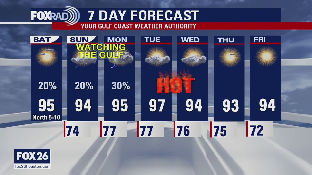
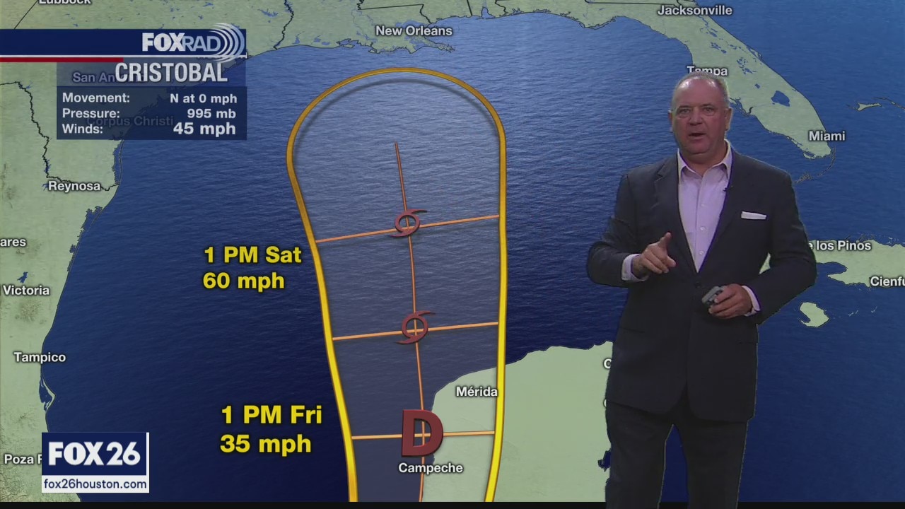
Monday weather forecast
A very hot pattern is setting up for this week with daily high temperatures in the mid to upper 90s. The highest heat index values should occur today and Tueaday, so a heat advisory may be issued. A rain band connected to tropical depression Cristobal could bring us a few afternoon storms today.
A very hot pattern is setting up for this week with daily high temperatures in the mid to upper 90s. The highest heat index values should occur today and Tueaday, so a heat advisory may be issued. A rain band connected to tropical depression Cristobal could bring us a few afternoon storms today.
Monday Morning Weather Forecast
Your Gulf Coast Weather Authority Meteorologist John Dawson looks ahead to this week's hot temperatures.
Your Gulf Coast Weather Authority Meteorologist John Dawson looks ahead to this week's hot temperatures.
Houston area weather forecast 6/7
With Cristobal expecting to make landfall later today, Houston remains on the 'dry' and 'hot' side of the storm with temperatures expected to soar into the mid and upper 90s once again today. We may see a few showers develop each of Houston, but otherwise rain chances will remain slim even into next week.
With Cristobal expecting to make landfall later today, Houston remains on the 'dry' and 'hot' side of the storm with temperatures expected to soar into the mid and upper 90s once again today. We may see a few showers develop each of Houston, but otherwise rain chances will remain slim even into next week.
Sunday Morning Weather Forecast
Your Gulf Coast Weather Authority Meteorologist John Dawson gives you a look at possible rainfall headed our way.
Your Gulf Coast Weather Authority Meteorologist John Dawson gives you a look at possible rainfall headed our way.
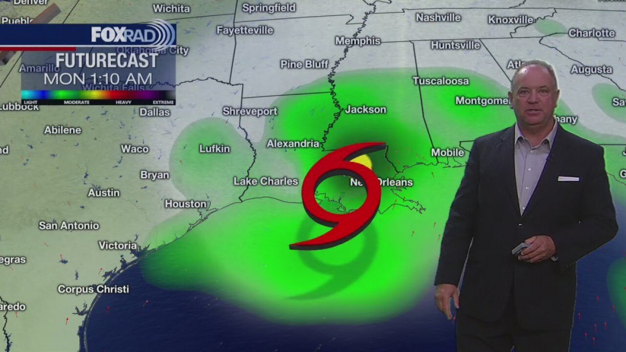
Houston area weather forecast 6/6
While we watch Cristobal churn in the Gulf of Mexico, it is expected to remain east of the Houston area with landfall occurring sometime late Sunday night into Monday along the Louisiana coastline. Since we are on the western side, expect hot weather the next few days with isolated showers and storms possible in the afternoon.
While we watch Cristobal churn in the Gulf of Mexico, it is expected to remain east of the Houston area with landfall occurring sometime late Sunday night into Monday along the Louisiana coastline. Since we are on the western side, expect hot weather the next few days with isolated showers and storms possible in the afternoon.

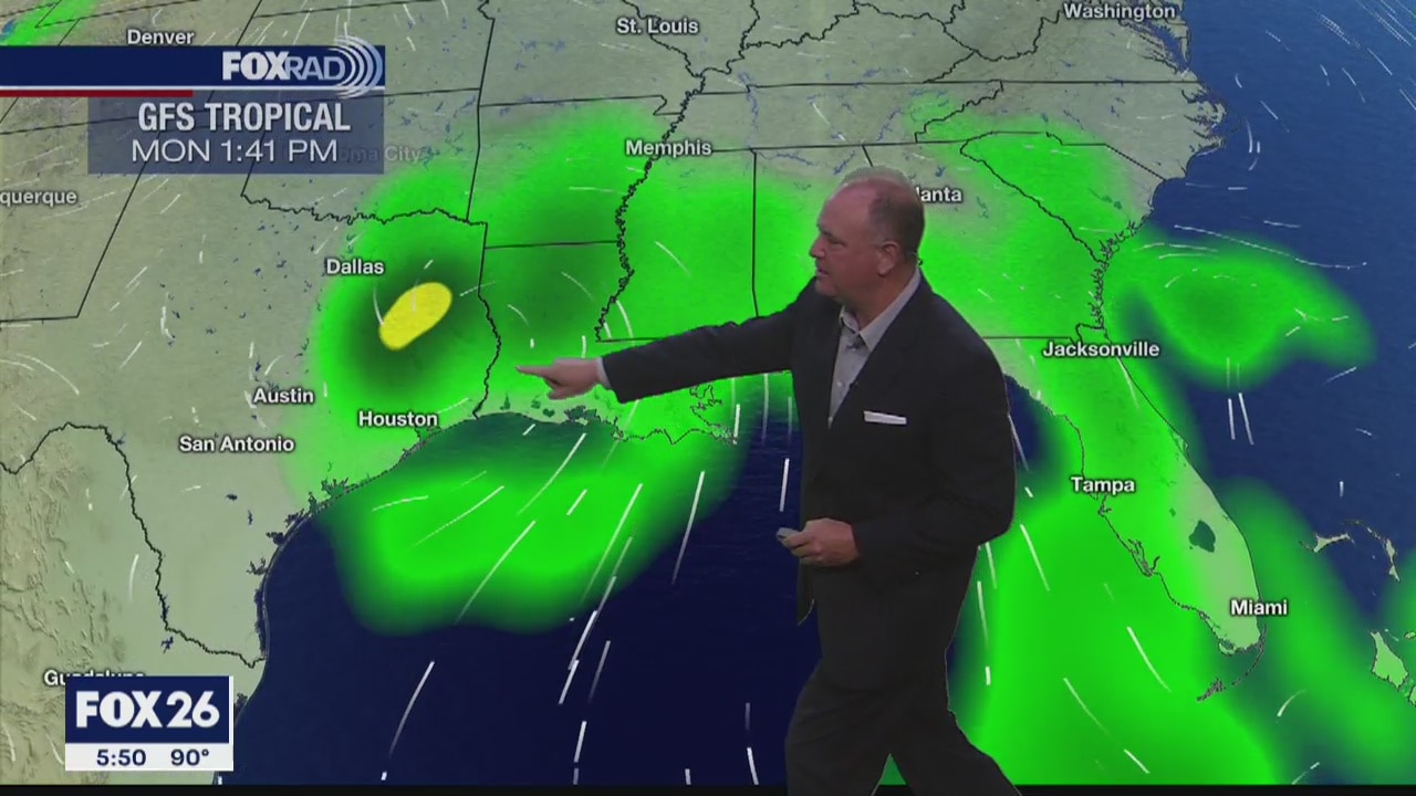
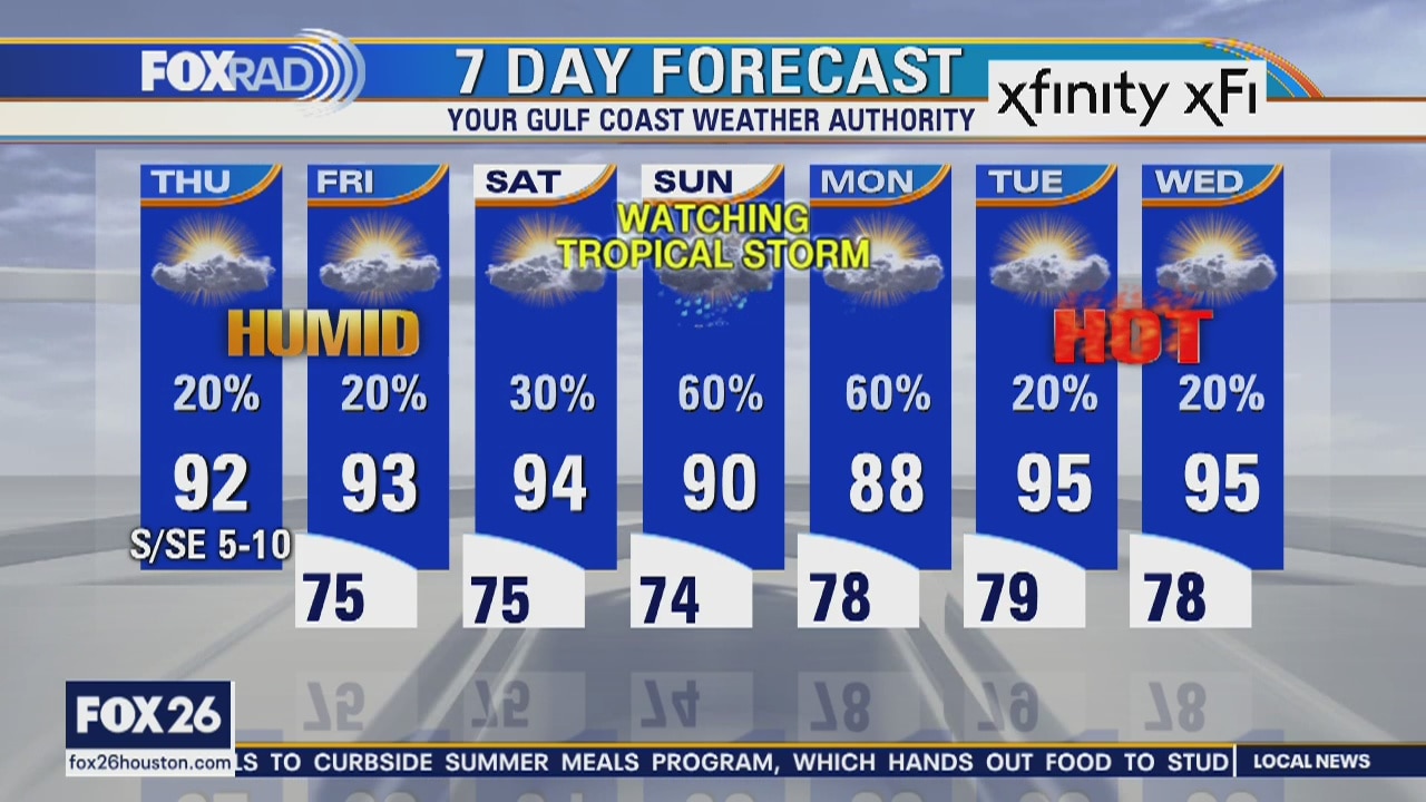
Friday weather forecast
As we watch Cristobal make its way closer to the northern Gulf Coast, our weather will be hot and humid for the next several days with isolated showers today and scattered storms tomorrow. Cristobal will make its closest approach to our area late Sunday and Monday as it moves inland most likely over Louisiana. We should feel breezy conditions with a chance for some related storms. Much of next week looks very hot.
As we watch Cristobal make its way closer to the northern Gulf Coast, our weather will be hot and humid for the next several days with isolated showers today and scattered storms tomorrow. Cristobal will make its closest approach to our area late Sunday and Monday as it moves inland most likely over Louisiana. We should feel breezy conditions with a chance for some related storms. Much of next week looks very hot.
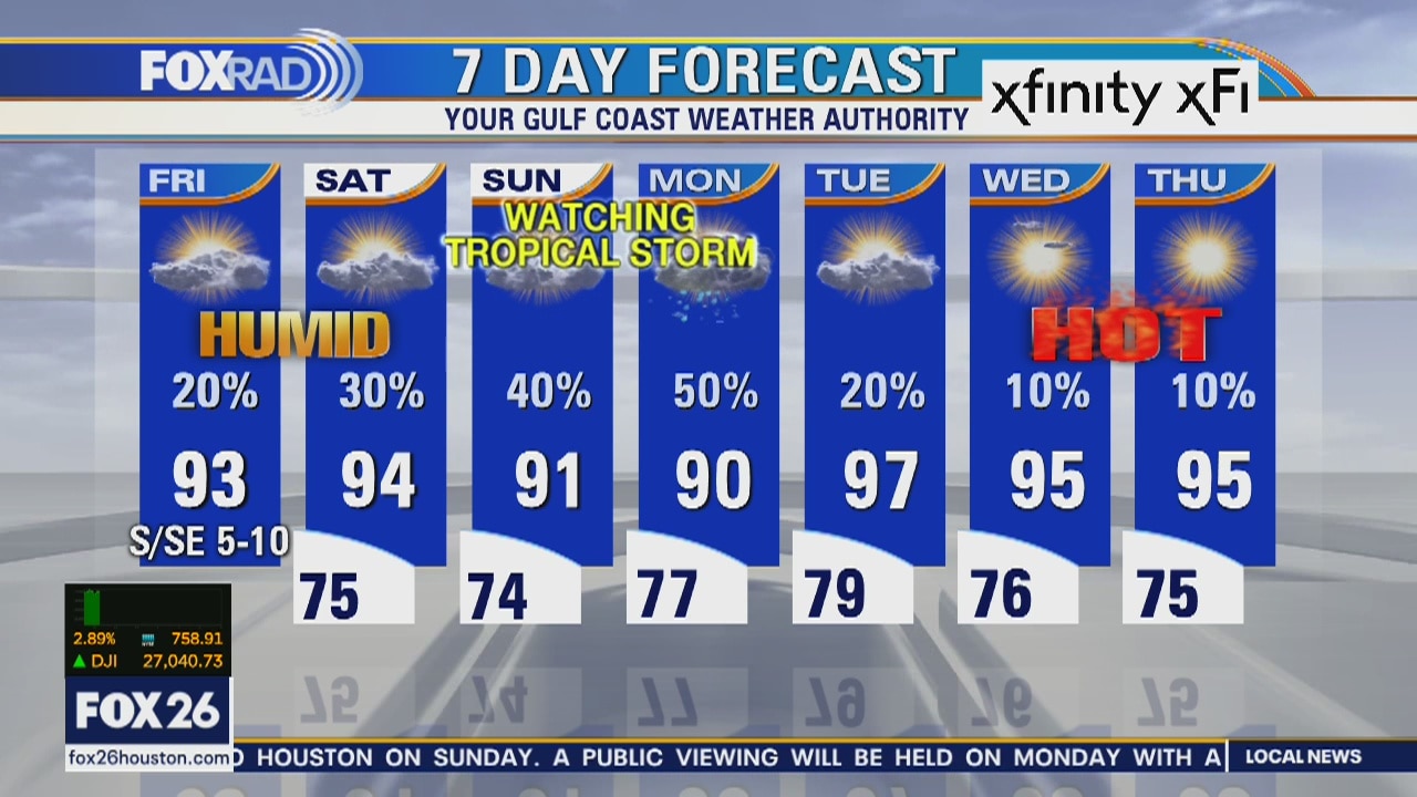
Friday Morning Weather Forecast
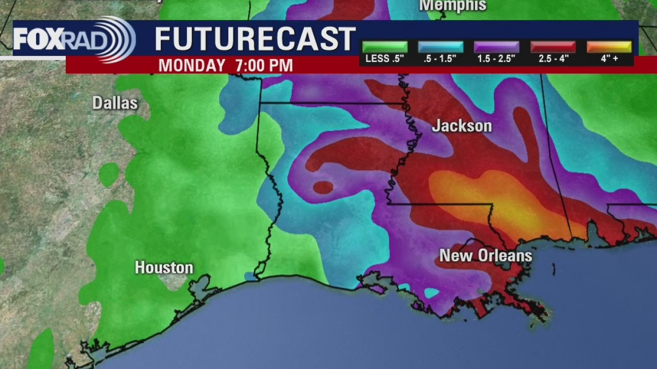
As expected, the latest NHC forecast pushes the cone mostly out of the Houston area. The computer models are agreeing more for landfall in central Louisiana. The forecast may change some more, but Houston remains on the clean side of it.
As expected, the latest NHC forecast pushes the cone mostly out of the Houston area. The computer models are agreeing more for landfall in central Louisiana. The forecast may change some more, but Houston remains on the clean side of it.
Thursday Evening Weather Forecast
The next couple of days will be very warm and humid. There will only be a 20% chance for mainly afternoon showers. The weekend looks much drier if Cristobal continues to remain east of Southeast Texas. It is still too early to call, but it appears the storm will stay in Louisiana. We will continue to monitor if the forecast changes dramatically.
The next couple of days will be very warm and humid. There will only be a 20% chance for mainly afternoon showers. The weekend looks much drier if Cristobal continues to remain east of Southeast Texas. It is still too early to call, but it appears the storm will stay in Louisiana. We will continue to monitor if the forecast changes dramatically.
Thursday weather forecast
Partly cloud, warm and humid with isolated afternoon storms. Highs in the low 90s.
Partly cloud, warm and humid with isolated afternoon storms. Highs in the low 90s.
Thursday Morning Weather Forecast
The next few days will continue to be very warm and humid. There will be some pop-up afternoon showers and rain chances will rise by Sunday depending on what happens with Cristobal. It's looking better for SE Texas as Louisiana appears to be the most likely landfall, but too early to call it.
The next few days will continue to be very warm and humid. There will be some pop-up afternoon showers and rain chances will rise by Sunday depending on what happens with Cristobal. It's looking better for SE Texas as Louisiana appears to be the most likely landfall, but too early to call it.