

Sunday morning weather forecast
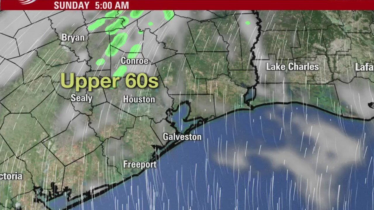
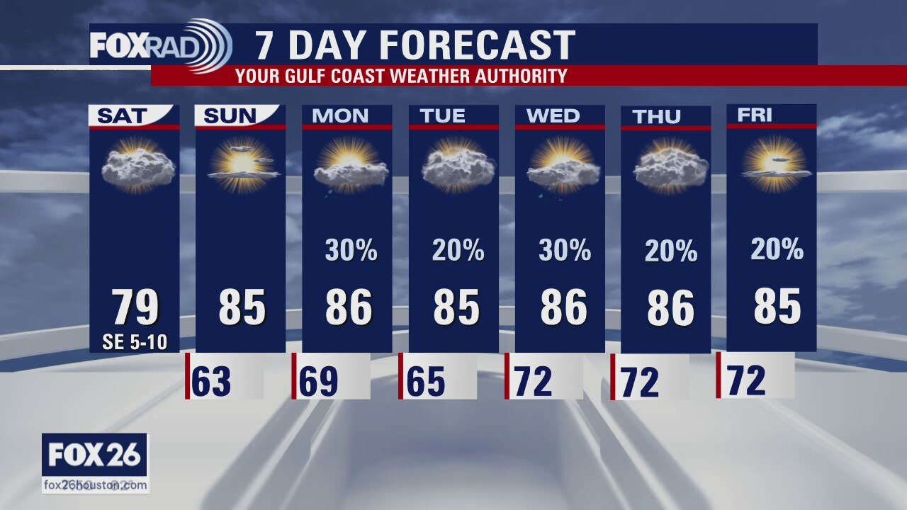
We should see a bit more sunshine for the second half of the weekend. It will also be a bit warmer especially Sunday morning. Look for a mix of sun and clouds for most of next week. There will be a chance for isolated storms and stray showers. Most overnights in the lower 70s and highs in the 80s. Don't expect another front until next weekend.
We should see a bit more sunshine for the second half of the weekend. It will also be a bit warmer especially Sunday morning. Look for a mix of sun and clouds for most of next week. There will be a chance for isolated storms and stray showers. Most overnights in the lower 70s and highs in the 80s. Don't expect another front until next weekend.
Houston-area weather forecast 10/17
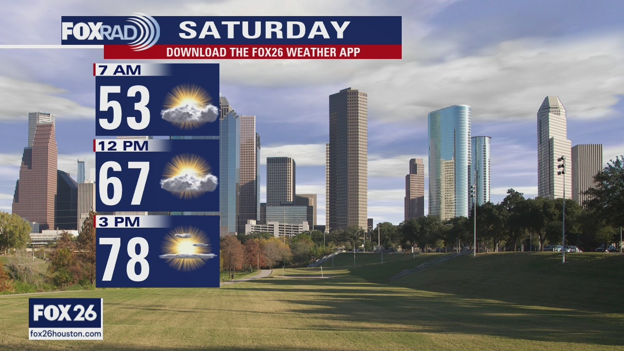
Our weekend is starting off on the cooler side, but clouds have kept us a bit warmer and as we work our way through the day those clouds will likely stick around. We?ll still be able to warm into the upper 70s this afternoon. Sunday is looking similar to Saturday, but we should be a few degrees warmer. Rain chances arrive on Monday as an unsettled weather pattern sets up. We?ll carry daily chances for rain through at least Friday with our best chance coming on Monday and Wednesday.
Our weekend is starting off on the cooler side, but clouds have kept us a bit warmer and as we work our way through the day those clouds will likely stick around. We?ll still be able to warm into the upper 70s this afternoon. Sunday is looking similar to Saturday, but we should be a few degrees warmer. Rain chances arrive on Monday as an unsettled weather pattern sets up. We?ll carry daily chances for rain through at least Friday with our best chance coming on Monday and Wednesday.
Nice weekend up ahead
The skies will clear later on Saturday and the weekend looks nice with highs in the 70s and 80s. The coming week will have a daily chance for rain, but it doesn?t look overly soggy and high temps will still be in the 80s. Enjoy your weekend!
The skies will clear later on Saturday and the weekend looks nice with highs in the 70s and 80s. The coming week will have a daily chance for rain, but it doesn?t look overly soggy and high temps will still be in the 80s. Enjoy your weekend!
Friday weather forecast
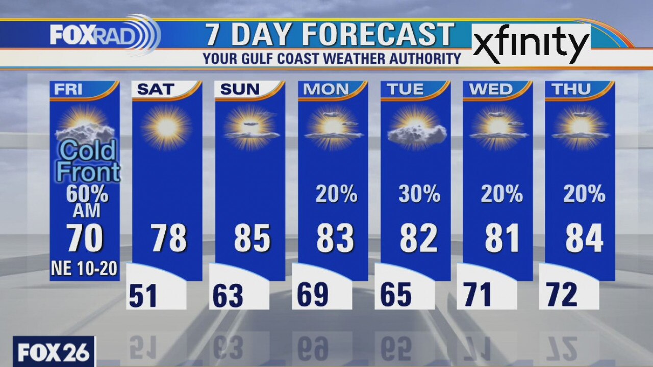
Cold front moving through Houston on Friday. Look for showers and clouds in the morning with slowly clearing skies in the afternoon. High temps will only be around 70 with dry Northeast breeze. Weekend looks fantastic with plenty of sunshine. Rain chances increase with the return of the work week on Monday.
Cold front moving through Houston on Friday. Look for showers and clouds in the morning with slowly clearing skies in the afternoon. High temps will only be around 70 with dry Northeast breeze. Weekend looks fantastic with plenty of sunshine. Rain chances increase with the return of the work week on Monday.
Friday morning weather forecast
A front will push through the Houston area this evening and brief showers will be likely as it pushes to the coast. Friday starts off cloudy, but the skies will clear as it turns breezy and cooler for most of the day. The weekend looks nice, but showers will be back in the forecast early next week.
A front will push through the Houston area this evening and brief showers will be likely as it pushes to the coast. Friday starts off cloudy, but the skies will clear as it turns breezy and cooler for most of the day. The weekend looks nice, but showers will be back in the forecast early next week.
Thursday Weather Forecast
A front will push through the Houston area this evening and brief showers will be likely as it pushes to the coast. Friday starts off cloudy, but the skies will clear as it turns breezy and cooler for most of the day. The weekend looks nice, but showers will be back in the forecast early next week.
A front will push through the Houston area this evening and brief showers will be likely as it pushes to the coast. Friday starts off cloudy, but the skies will clear as it turns breezy and cooler for most of the day. The weekend looks nice, but showers will be back in the forecast early next week.
Thursday weather forecast
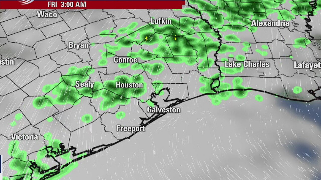
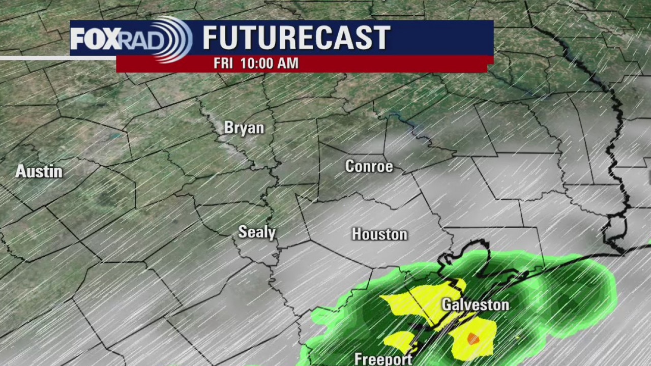
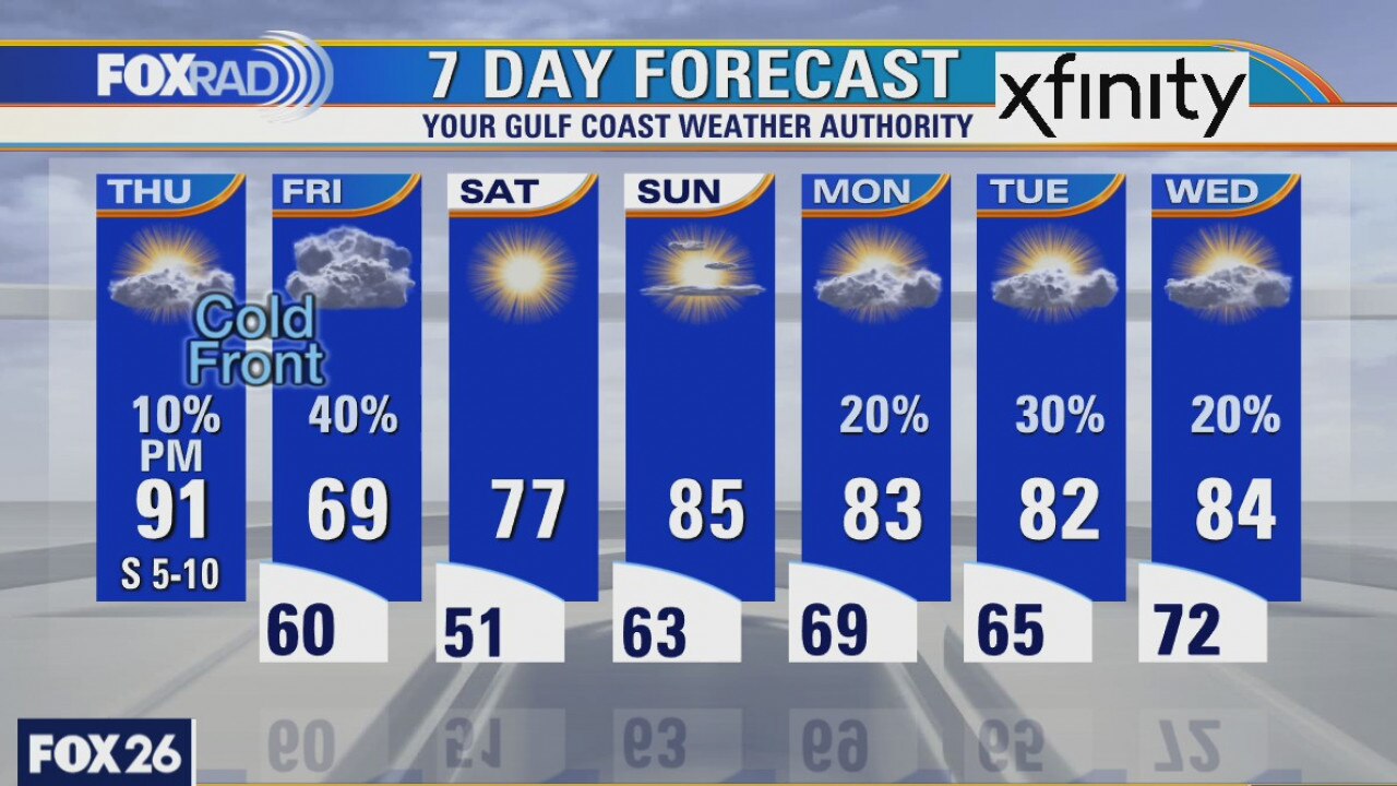
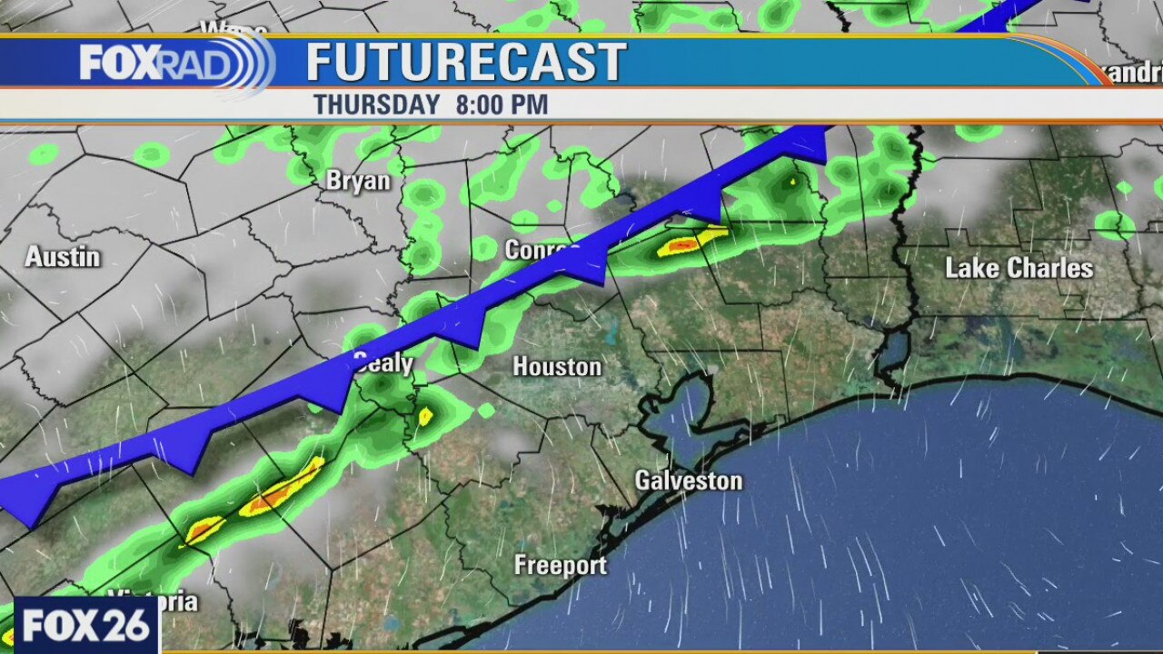
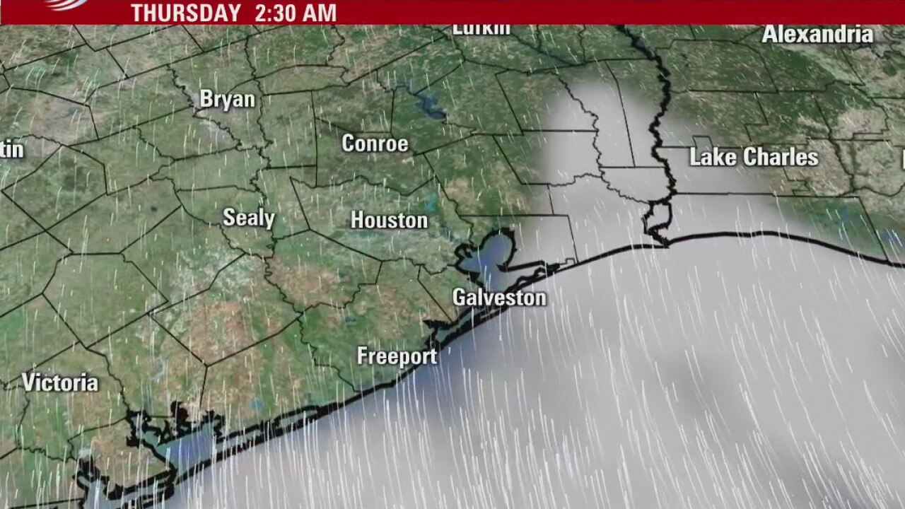
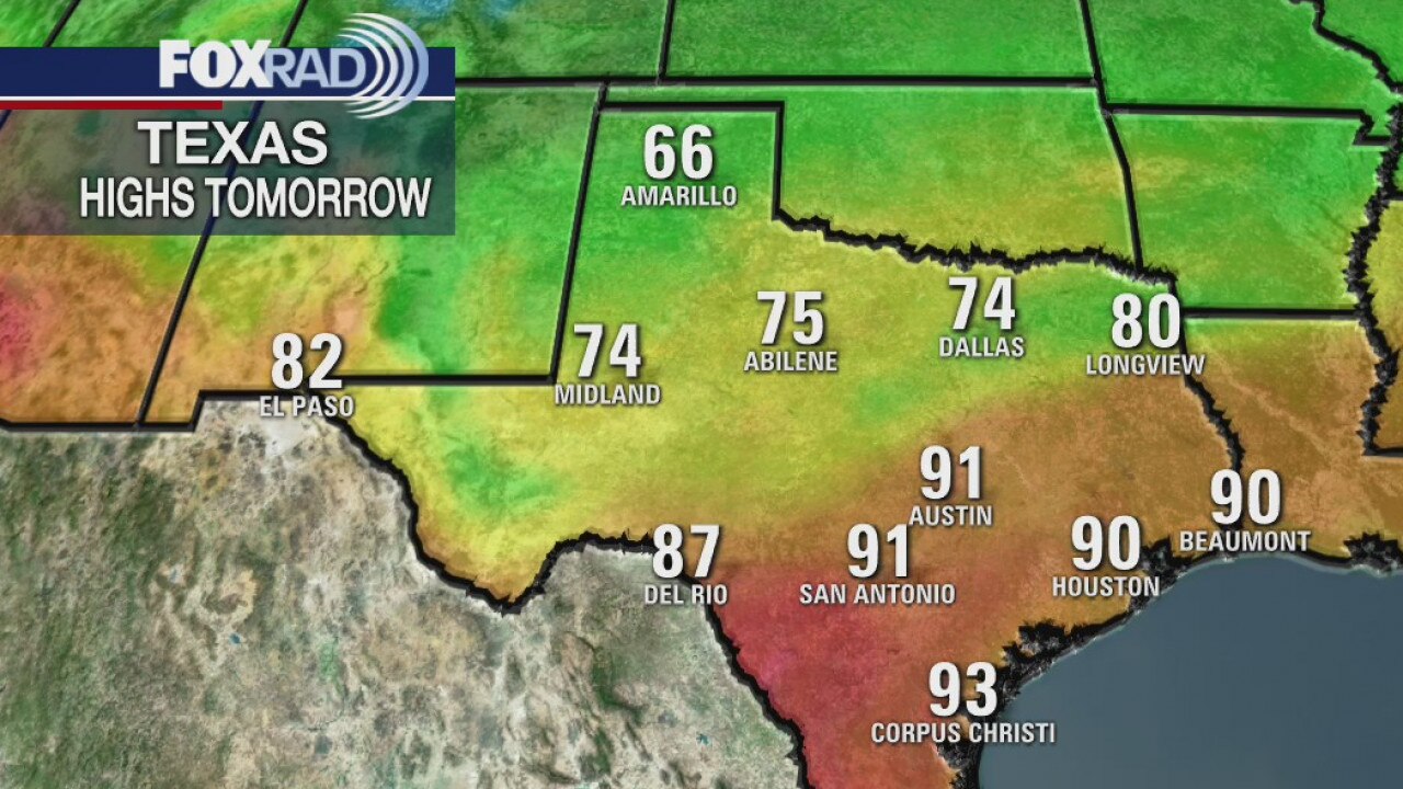
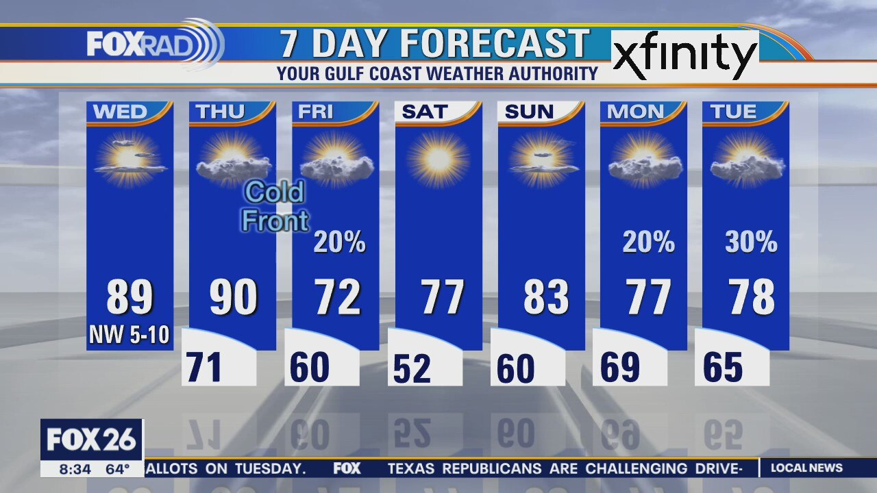
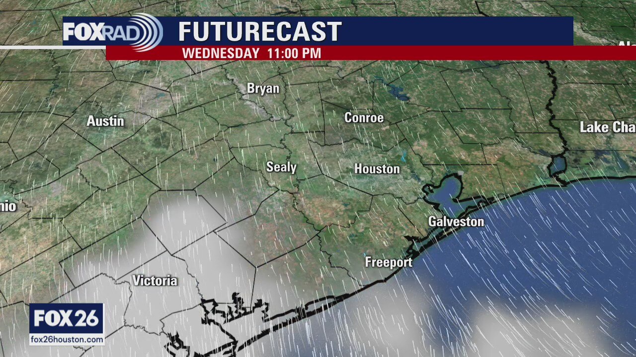
While Thursday is starting off on the warmer side, it will end quite the opposite as a cold front is forecast to move through the entire area this evening. Highs today could reach the low 90s under a mostly sunny sky. We'll then turn our attention to a cold front that will be blowing in from the north and west as we head into the evening, mainly after 6PM. Showers will also be possible along and behind the cold front with those rain chances sticking around the first part of the day on Friday. Clouds will limit warming on Friday so highs will struggle to get out of the 60s. The weekend, on the other hand, is looking very pleasant with highs in the mid to upper 70s and low 80s both days.
While Thursday is starting off on the warmer side, it will end quite the opposite as a cold front is forecast to move through the entire area this evening. Highs today could reach the low 90s under a mostly sunny sky. We'll then turn our attention to a cold front that will be blowing in from the north and west as we head into the evening, mainly after 6PM. Showers will also be possible along and behind the cold front with those rain chances sticking around the first part of the day on Friday. Clouds will limit warming on Friday so highs will struggle to get out of the 60s. The weekend, on the other hand, is looking very pleasant with highs in the mid to upper 70s and low 80s both days.
Thursday weather forecast
While Thursday is starting off on the warmer side, it will end quite the opposite as a cold front is forecast to move through the entire area this evening. Highs today could reach the low 90s under a mostly sunny sky. We'll then turn our attention to a cold front that will be blowing in from the north and west as we head into the evening, mainly after 6PM. Showers will also be possible along and behind the cold front with those rain chances sticking around the first part of the day on Friday. Clouds will limit warming on Friday so highs will struggle to get out of the 60s. The weekend, on the other hand, is looking very pleasant with highs in the mid to upper 70s and low 80s both days.
While Thursday is starting off on the warmer side, it will end quite the opposite as a cold front is forecast to move through the entire area this evening. Highs today could reach the low 90s under a mostly sunny sky. We'll then turn our attention to a cold front that will be blowing in from the north and west as we head into the evening, mainly after 6PM. Showers will also be possible along and behind the cold front with those rain chances sticking around the first part of the day on Friday. Clouds will limit warming on Friday so highs will struggle to get out of the 60s. The weekend, on the other hand, is looking very pleasant with highs in the mid to upper 70s and low 80s both days.
Tuesday morning weather forecast
It?s going to be a warm day Thursday with highs in the low 90s. A front arrives late in the day and that will clear things out for a beautiful weekend. The chance for some showers will return by around Monday.
It?s going to be a warm day Thursday with highs in the low 90s. A front arrives late in the day and that will clear things out for a beautiful weekend. The chance for some showers will return by around Monday.
Wednesday Weather Forecast
It?s going to be a warm day Thursday with highs in the low 90s. A front arrives late in the day and that will clear things out for a beautiful weekend. The chance for some showers will return by around Monday.
It?s going to be a warm day Thursday with highs in the low 90s. A front arrives late in the day and that will clear things out for a beautiful weekend. The chance for some showers will return by around Monday.
Wednesday weather forecast
With temperatures in the low 60s this morning, some areas are waking up to patches of fog. That should dissipate as we head later into the morning. We'll reach the upper 80s, possibly even the low 90s, this afternoon under mostly sunny skies. Our next cold front appears to be on track as we head toward Thursday night and Friday. Highs on Thursday will near 90 and then with the frontal passage, highs on Friday will struggle to get out of the 60s! It'll be quite the fall chill and our weekend is looking quiet and dry because of it.
With temperatures in the low 60s this morning, some areas are waking up to patches of fog. That should dissipate as we head later into the morning. We'll reach the upper 80s, possibly even the low 90s, this afternoon under mostly sunny skies. Our next cold front appears to be on track as we head toward Thursday night and Friday. Highs on Thursday will near 90 and then with the frontal passage, highs on Friday will struggle to get out of the 60s! It'll be quite the fall chill and our weekend is looking quiet and dry because of it.
Mild mornings and warm afternoons
Wednesday and Thursday will be mild in the morning and warm in the afternoons. A stronger front arrives late Thursday and that brings a few showers early Friday morning and then the skies will be clearing. The forecast looks great through the weekend and into the coming week.
Wednesday and Thursday will be mild in the morning and warm in the afternoons. A stronger front arrives late Thursday and that brings a few showers early Friday morning and then the skies will be clearing. The forecast looks great through the weekend and into the coming week.
Tuesday Evening Weather Forecast
Wed and Thurs will be mild in the morning and warm in the afternoons. A stronger front arrives late Thurs and that brings a few showers early Fri morning and then the skies will be clearing. The forecast looks great through the weekend and into the coming week
Wed and Thurs will be mild in the morning and warm in the afternoons. A stronger front arrives late Thurs and that brings a few showers early Fri morning and then the skies will be clearing. The forecast looks great through the weekend and into the coming week
Tuesday weather forecast
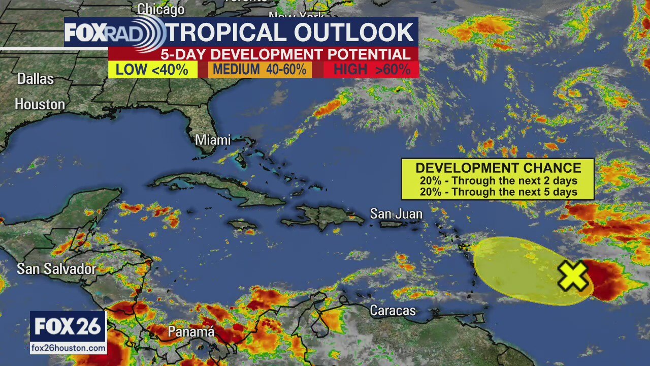
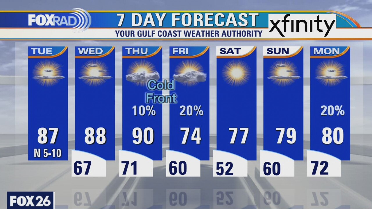
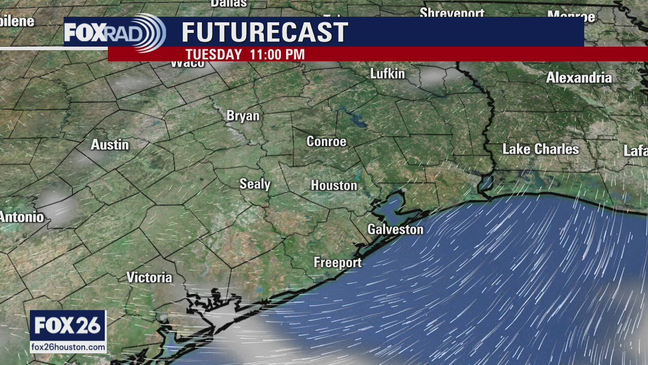
Our first of two cold fronts this week moved through on Monday and this morning we're waking up to slightly cooler temperatures and drier air. Humidity will stay in check all day as temps warm into the mid and upper 80s. Dry weather will persist with very limited rain chances until a cold front arrives late Thursday into Friday. While it might bring showers, the bigger story will be the drop in humidity and temperatures. Highs on Friday may only make it into the low and mid 70s with lows early Saturday dipping into the low 50s!
Our first of two cold fronts this week moved through on Monday and this morning we're waking up to slightly cooler temperatures and drier air. Humidity will stay in check all day as temps warm into the mid and upper 80s. Dry weather will persist with very limited rain chances until a cold front arrives late Thursday into Friday. While it might bring showers, the bigger story will be the drop in humidity and temperatures. Highs on Friday may only make it into the low and mid 70s with lows early Saturday dipping into the low 50s!
Cooler temps on the way
A weak cold front is moving through today, but it will bring the temperatures down into the 60s for lows and 80s for highs until about Thursday. That is when a stronger front arrives and we will end the week with highs in the 70s and lows in the 50s. That?s more like it!
A weak cold front is moving through today, but it will bring the temperatures down into the 60s for lows and 80s for highs until about Thursday. That is when a stronger front arrives and we will end the week with highs in the 70s and lows in the 50s. That?s more like it!
Monday Weather Forecast
A weak cold front is moving through today, but it will bring the temps down into the 60s for lows and 80s for highs until about Thursday. That is when a stronger front arrives and we will end the week with highs in the 70s and lows in the 50s.
A weak cold front is moving through today, but it will bring the temps down into the 60s for lows and 80s for highs until about Thursday. That is when a stronger front arrives and we will end the week with highs in the 70s and lows in the 50s.
Monday weather forecast
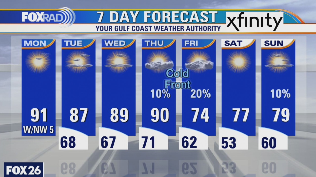
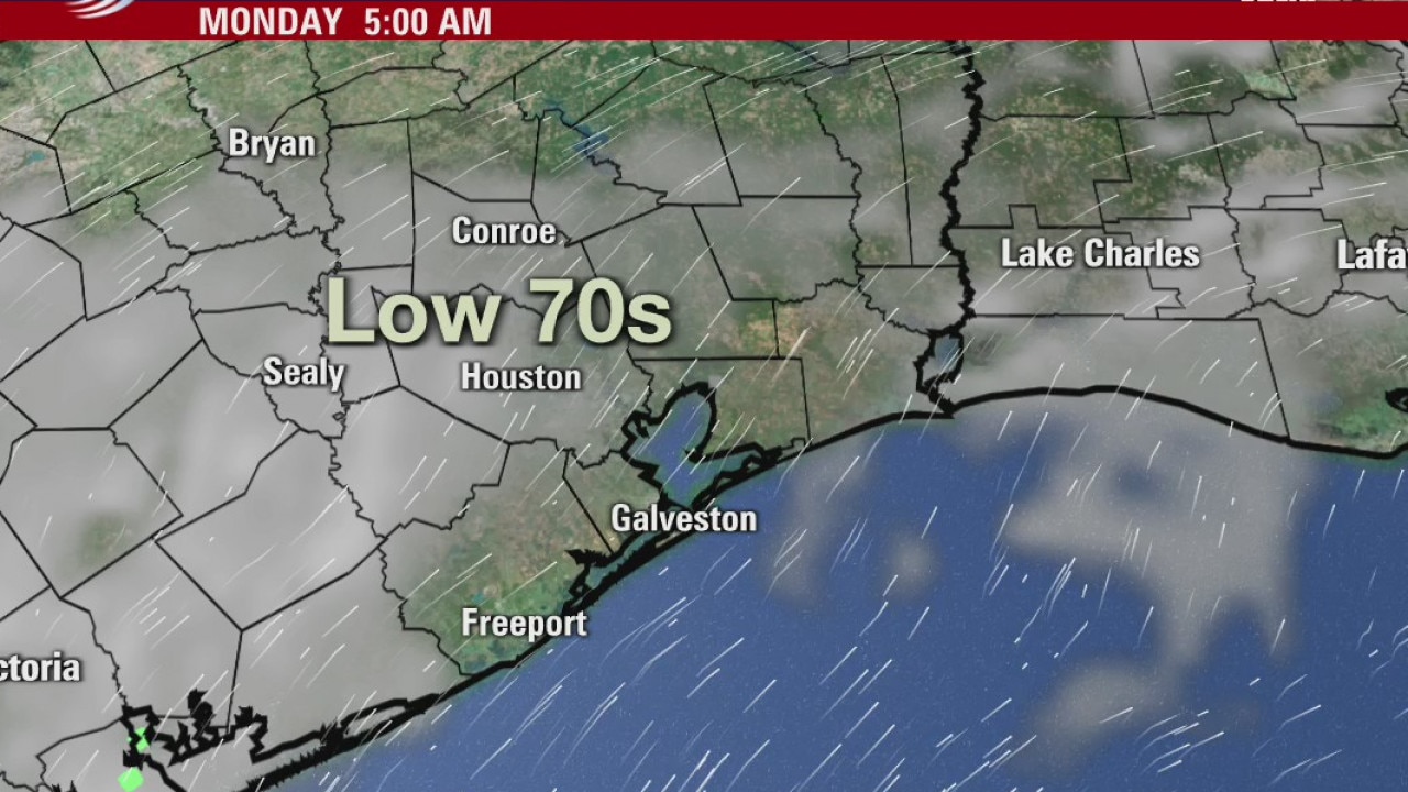
We're kicking off the workweek a bit foggy, but skies should clear later this morning and we should warm well into the upper 80s and low 90s. A weak front will slide through the area later today, but it's not going to have a huge impact on us. We'll see a decrease in the humidity and highs will be knocked back by about 5 degrees or so. The stronger cold front is set to arrive on Thursday into Friday where highs on Friday may only reach the lower to mid 70s.
We're kicking off the workweek a bit foggy, but skies should clear later this morning and we should warm well into the upper 80s and low 90s. A weak front will slide through the area later today, but it's not going to have a huge impact on us. We'll see a decrease in the humidity and highs will be knocked back by about 5 degrees or so. The stronger cold front is set to arrive on Thursday into Friday where highs on Friday may only reach the lower to mid 70s.
Monday morning weather forecast
Looking for more amazing October weather in Houston? Hang in there, it should return at the end of the week. In the mean time, looks like a warm and dry forecast.
Looking for more amazing October weather in Houston? Hang in there, it should return at the end of the week. In the mean time, looks like a warm and dry forecast.
Houston-area weather forecast 10/11
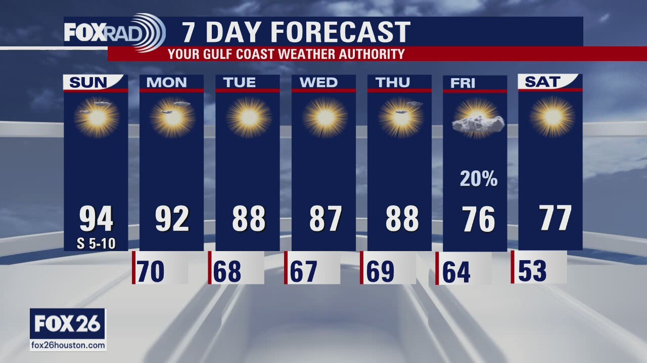
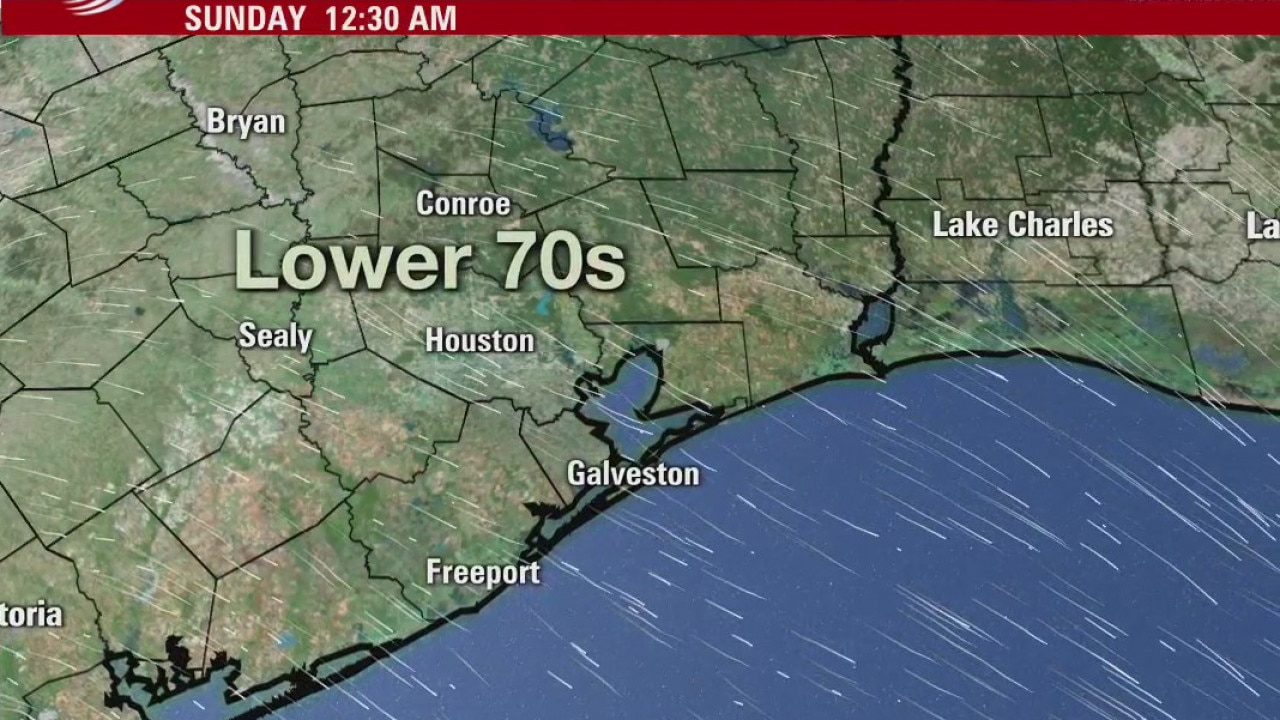
Sunday is starting off foggy with a dense fog advisory for a part of the viewing area until 9AM. We will see that fog dissipate after the sun rises and temperatures will warm quickly today, highs likely reaching the low 90s. We could even be close to a record high. A weak cold front will interact with the area on Monday and Tuesday, but a stronger one will wait until Thursday to arrive. Until then expect temperatures, each afternoon, to rise into the mid and upper 80s.
Sunday is starting off foggy with a dense fog advisory for a part of the viewing area until 9AM. We will see that fog dissipate after the sun rises and temperatures will warm quickly today, highs likely reaching the low 90s. We could even be close to a record high. A weak cold front will interact with the area on Monday and Tuesday, but a stronger one will wait until Thursday to arrive. Until then expect temperatures, each afternoon, to rise into the mid and upper 80s.
Sunday morning weather forecast
Ready for some heat? Houston could set a record high temperature Sunday afternoon. Next front comes at the end of the week.
Ready for some heat? Houston could set a record high temperature Sunday afternoon. Next front comes at the end of the week.