

Monday Morning Weather update 6:30AM
Meteorologist Stephen Morgan provides the 6:30 am Update
Meteorologist Stephen Morgan provides the 6:30 am Update
5AM Monday Morning Weather update
Wind Chill warning and more in this 5AM Weather update
Wind Chill warning and more in this 5AM Weather update

6AM Monday Morning Weather update
Wind Chill warning and more in this 5AM Weather update
Wind Chill warning and more in this 5AM Weather update
Monday morning weather update 4AM
Monday morning weather update 4AM
Monday morning weather update 4AM
Weather update Monday 3:30AM
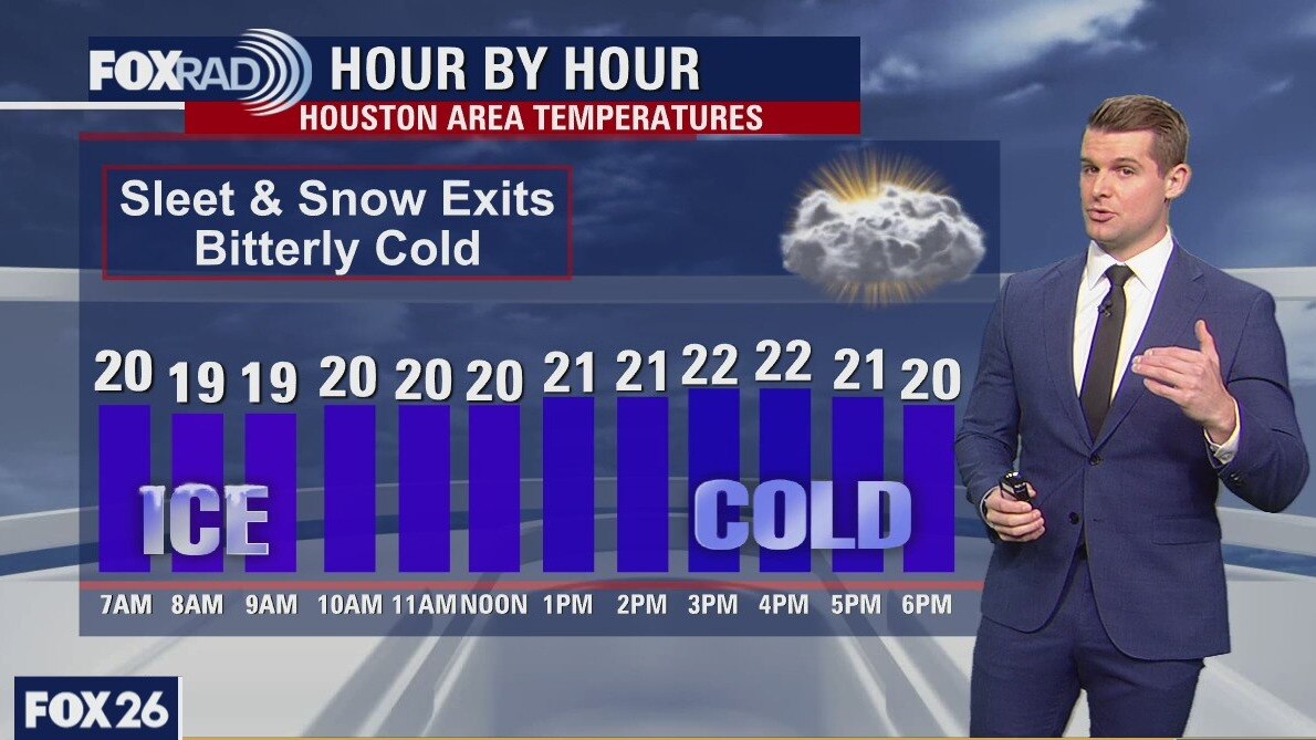
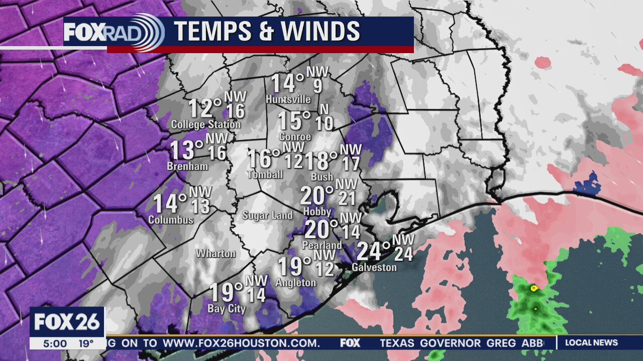
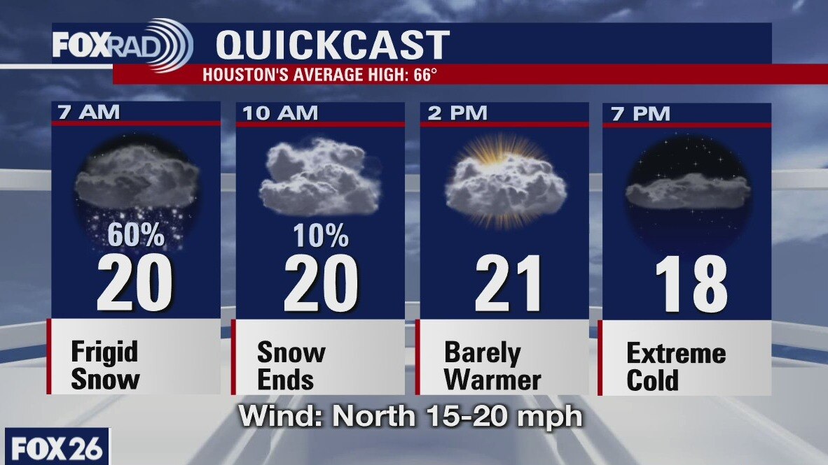
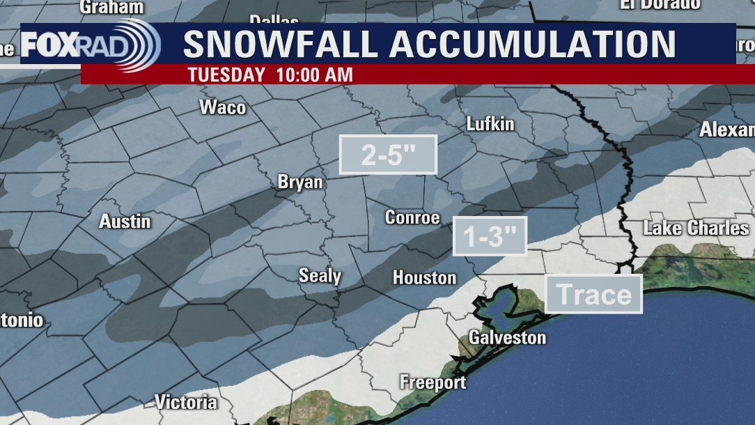
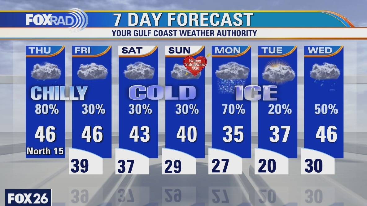
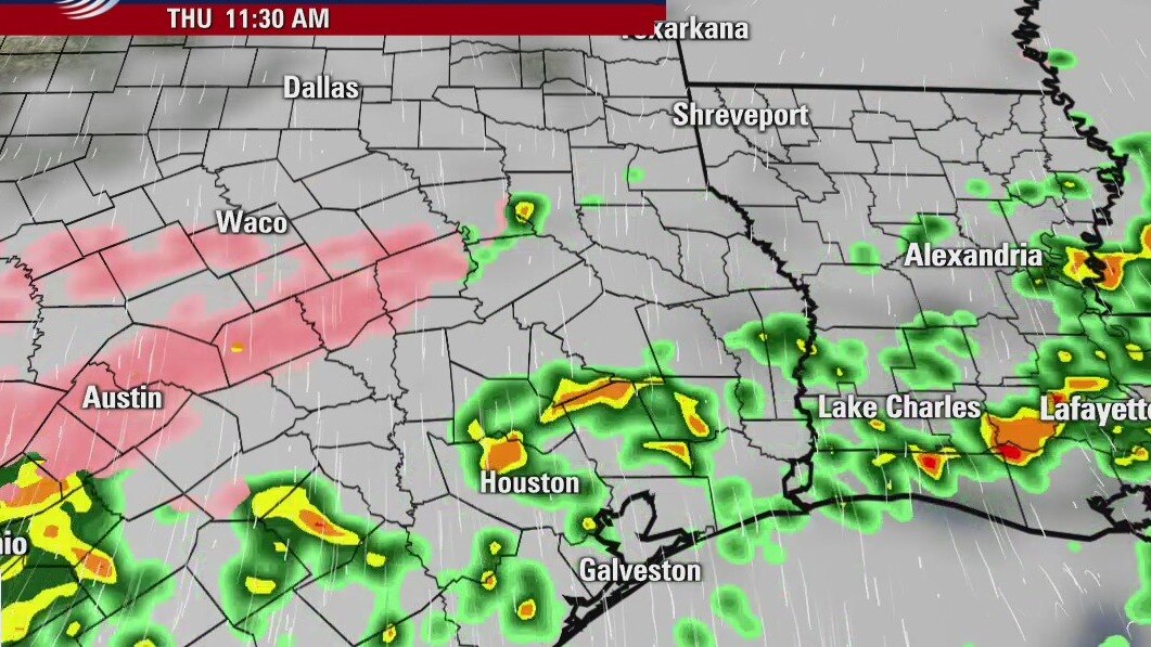
Thundersnow in Houston area. Monday morning 3:30am weather update. Snow, several inches in spots will continue through mid-morning. Ice will persist on area roads all day and through much of tomorrow. Expect dangerous wind chills in the single digits with highs today only in the low 20s.
Thundersnow in Houston area. Monday morning 3:30am weather update. Snow, several inches in spots will continue through mid-morning. Ice will persist on area roads all day and through much of tomorrow. Expect dangerous wind chills in the single digits with highs today only in the low 20s.

Sunday Evening Weather Forecast
Wintry Precipitation starts tonight and ends Monday afternoon. Dangerously cold Monday night and another round of winter precipitation hits Houston on Wednesday.
Wintry Precipitation starts tonight and ends Monday afternoon. Dangerously cold Monday night and another round of winter precipitation hits Houston on Wednesday.

Houston-area weather forecast: February 14
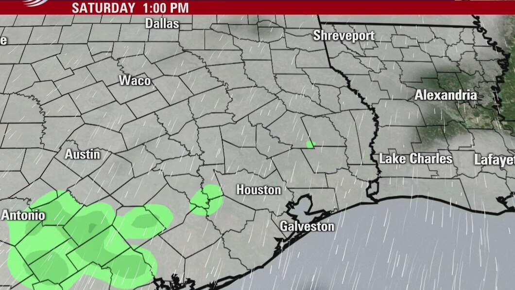
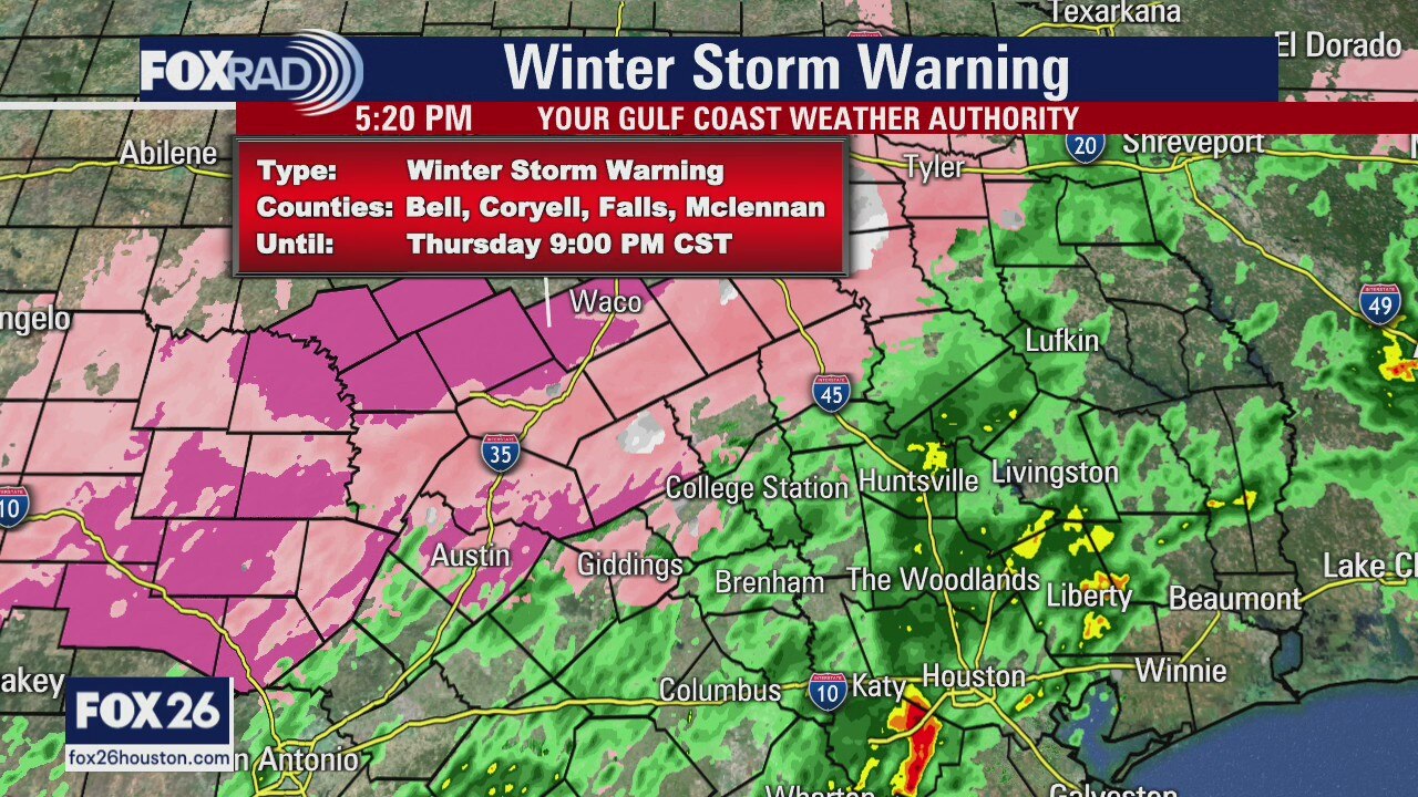
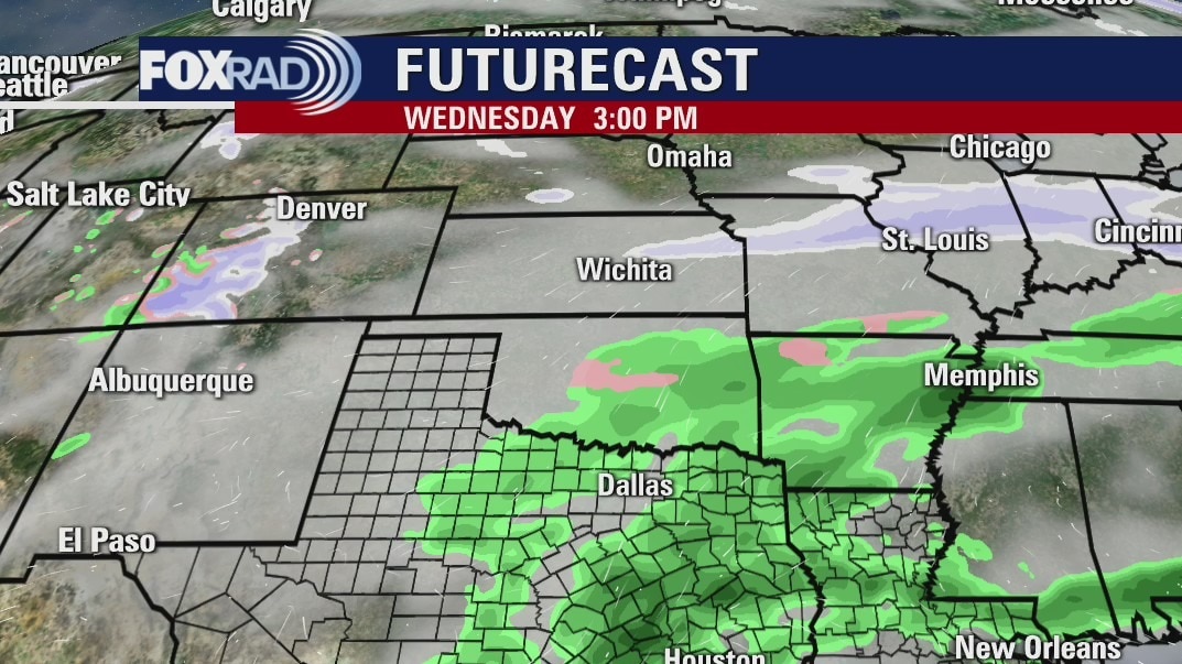
A major winter storm will impact southeast Texas from Sunday night into Monday with bitterly cold temperatures expected Monday into Tuesday. Light freezing drizzle and rain has been reported north and west of Houston this morning, but a quick break in the activity is expected before the main event later tonight. A mix of freezing rain and sleet is expected to fall over the entire area as temperatures continue to drop throughout the duration of the event. Areawide, anywhere between 0.10" - 0.25" of ice accretion is expected with sleet and snow accumulations expected to range from a dusting near the coast to upwards of 4" around Bryan & College Station. Tuesday morning will be bitterly cold with temperatures dipping near 10 degrees, if not lower. Another shot of wintry precipitation arrives on Wednesday.
A major winter storm will impact southeast Texas from Sunday night into Monday with bitterly cold temperatures expected Monday into Tuesday. Light freezing drizzle and rain has been reported north and west of Houston this morning, but a quick break in the activity is expected before the main event later tonight. A mix of freezing rain and sleet is expected to fall over the entire area as temperatures continue to drop throughout the duration of the event. Areawide, anywhere between 0.10" - 0.25" of ice accretion is expected with sleet and snow accumulations expected to range from a dusting near the coast to upwards of 4" around Bryan & College Station. Tuesday morning will be bitterly cold with temperatures dipping near 10 degrees, if not lower. Another shot of wintry precipitation arrives on Wednesday.
Saturday Evening Weather Forecast
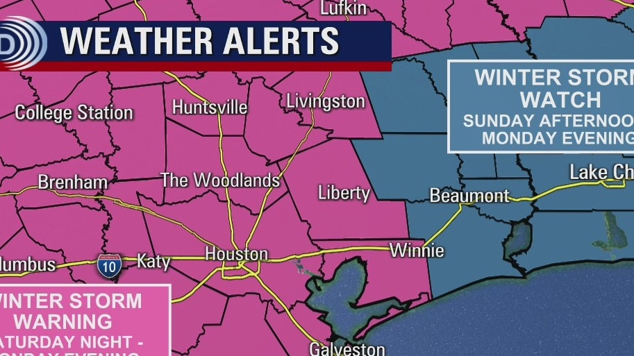
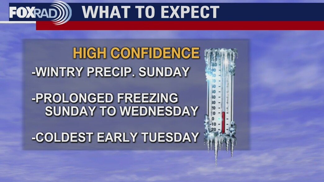
A winter storm will impact southeast Texas on Valentine’s Day and last through Monday with frigid temperatures expected to filter in behind the storm. Winter Storm Warnings have been posted north and west of Houston as freezing drizzle could begin this evening before the main winter storm arrives Sunday evening. Other counties, including Harris, remain under a Winter Storm Watch. As we remain close to the freezing mark this morning, areas north of Houston have reported icy overpasses and bridges and that threat will continue through the morning. Moisture will build in on Sunday evening with rain, freezing rain and sleet all expected to last until Monday afternoon or early evening. Ice accumulations, up to 0.30” will be possible north of Houston with no more than 0.25” in the city. The freezing rain and sleet is expected to transition to all snow by Monday with accumulations possible, especially north of Houston. Monday night is when temperatures are expected to drop into the teens, if not lower. Wind chill values could drop below freezing by Tuesday morning. Colder air will remain in place and on Wednesday, another system may move through and bring additional wintry precipitation
A winter storm will impact southeast Texas on Valentine’s Day and last through Monday with frigid temperatures expected to filter in behind the storm. Winter Storm Warnings have been posted north and west of Houston as freezing drizzle could begin this evening before the main winter storm arrives Sunday evening. Other counties, including Harris, remain under a Winter Storm Watch. As we remain close to the freezing mark this morning, areas north of Houston have reported icy overpasses and bridges and that threat will continue through the morning. Moisture will build in on Sunday evening with rain, freezing rain and sleet all expected to last until Monday afternoon or early evening. Ice accumulations, up to 0.30” will be possible north of Houston with no more than 0.25” in the city. The freezing rain and sleet is expected to transition to all snow by Monday with accumulations possible, especially north of Houston. Monday night is when temperatures are expected to drop into the teens, if not lower. Wind chill values could drop below freezing by Tuesday morning. Colder air will remain in place and on Wednesday, another system may move through and bring additional wintry precipitation

Winter storm to impact southeast Texas, Houston-area
Winter Storm Warnings have been posted north and west of Houston as freezing drizzle could begin this evening before the main winter storm arrives Sunday evening. Other counties, including Harris, remain under a Winter Storm Watch. As we remain close to the freezing mark this morning, areas north of Houston have reported icy overpasses and bridges and that threat will continue through the morning. Moisture will build in on Sunday evening with rain, freezing rain and sleet all expected to last until Monday afternoon or early evening. The freezing rain and sleet is expected to transition to all snow by Monday with accumulations possible, especially north of Houston. Very cold air will filter in as the system exits.
Winter Storm Warnings have been posted north and west of Houston as freezing drizzle could begin this evening before the main winter storm arrives Sunday evening. Other counties, including Harris, remain under a Winter Storm Watch. As we remain close to the freezing mark this morning, areas north of Houston have reported icy overpasses and bridges and that threat will continue through the morning. Moisture will build in on Sunday evening with rain, freezing rain and sleet all expected to last until Monday afternoon or early evening. The freezing rain and sleet is expected to transition to all snow by Monday with accumulations possible, especially north of Houston. Very cold air will filter in as the system exits.
Saturday morning weather forecast
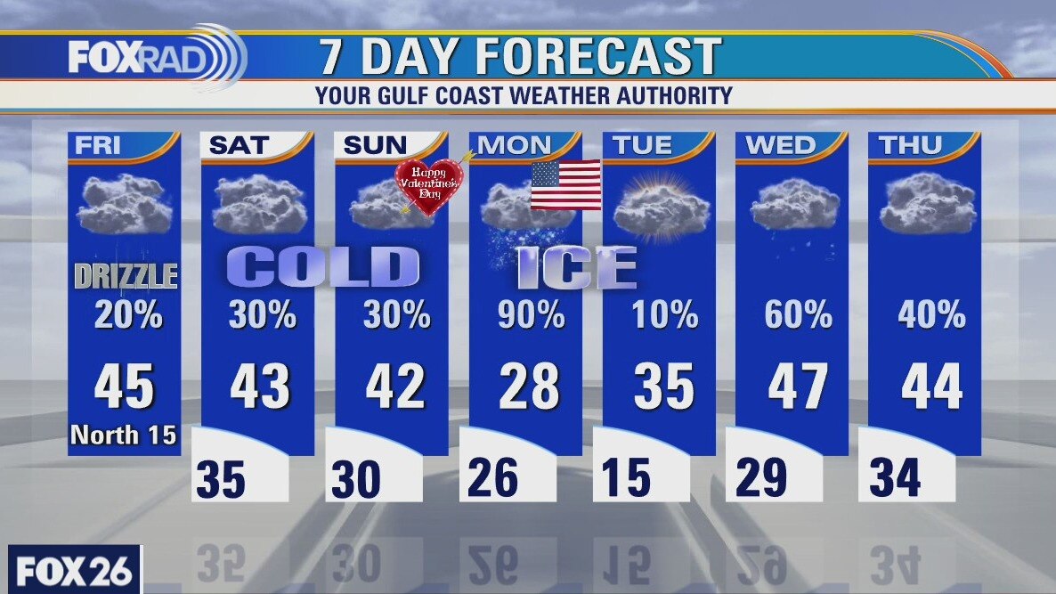
Saturday will be cold with a few showers and Sunday starts the same way, but wintry precip. will become likely by the night. Monday will a day to remember with snow, ice and cold air. Monday night will drop into the teens with a hard freeze.
Saturday will be cold with a few showers and Sunday starts the same way, but wintry precip. will become likely by the night. Monday will a day to remember with snow, ice and cold air. Monday night will drop into the teens with a hard freeze.
Friday Evening Weather Forecast
A Winter Storm Watch is posted for SE Texas and the Houston area from 4pm Sunday until 7pm Monday night. Periods of snow, sleet and freezing will impact the region. Snow amounts of 1-3 inches is expected along with icy roads. Freezing rain will create very hazardous driving conditions and we will all need to stay alert.
A Winter Storm Watch is posted for SE Texas and the Houston area from 4pm Sunday until 7pm Monday night. Periods of snow, sleet and freezing will impact the region. Snow amounts of 1-3 inches is expected along with icy roads. Freezing rain will create very hazardous driving conditions and we will all need to stay alert.
Friday weather forecast
It's a good idea to take advantage of today and tomorrow to head to the grocery store for food, batteries, pet food, baby supplies, all that before it gets nastier. Bundle up because wind chills today will remain in the 20s and 30s with isolated ice northwest of Houston. Conditions go downhill quickly Sunday night and Monday - freezing temps, wind, ice, the whole nine. Monday night and Tuesday morning still looks extremely cold.
It's a good idea to take advantage of today and tomorrow to head to the grocery store for food, batteries, pet food, baby supplies, all that before it gets nastier. Bundle up because wind chills today will remain in the 20s and 30s with isolated ice northwest of Houston. Conditions go downhill quickly Sunday night and Monday - freezing temps, wind, ice, the whole nine. Monday night and Tuesday morning still looks extremely cold.
Friday morning weather forecast
Temps below freezing, sleet and snow are all likely for SE Texas from the weekend into next week. Freezing rain could be the worst hazard, because bridges freeze faster because air moves below the road. The Houston area has elevated roads all over and driving will become hazardous by Saturday night. Be safe when the big freeze comes.
Temps below freezing, sleet and snow are all likely for SE Texas from the weekend into next week. Freezing rain could be the worst hazard, because bridges freeze faster because air moves below the road. The Houston area has elevated roads all over and driving will become hazardous by Saturday night. Be safe when the big freeze comes.
Thursday Evening Weather Forecast
The forecast low for Monday night in Houston is 15? and that is the coldest since 1989. The record low for Houston is 5? set way back on January 18, 1930. At least we won't be that cold this time. Three of the four coldest days all happened in the 1980s.
The forecast low for Monday night in Houston is 15? and that is the coldest since 1989. The record low for Houston is 5? set way back on January 18, 1930. At least we won't be that cold this time. Three of the four coldest days all happened in the 1980s.
Thursday weather forecast
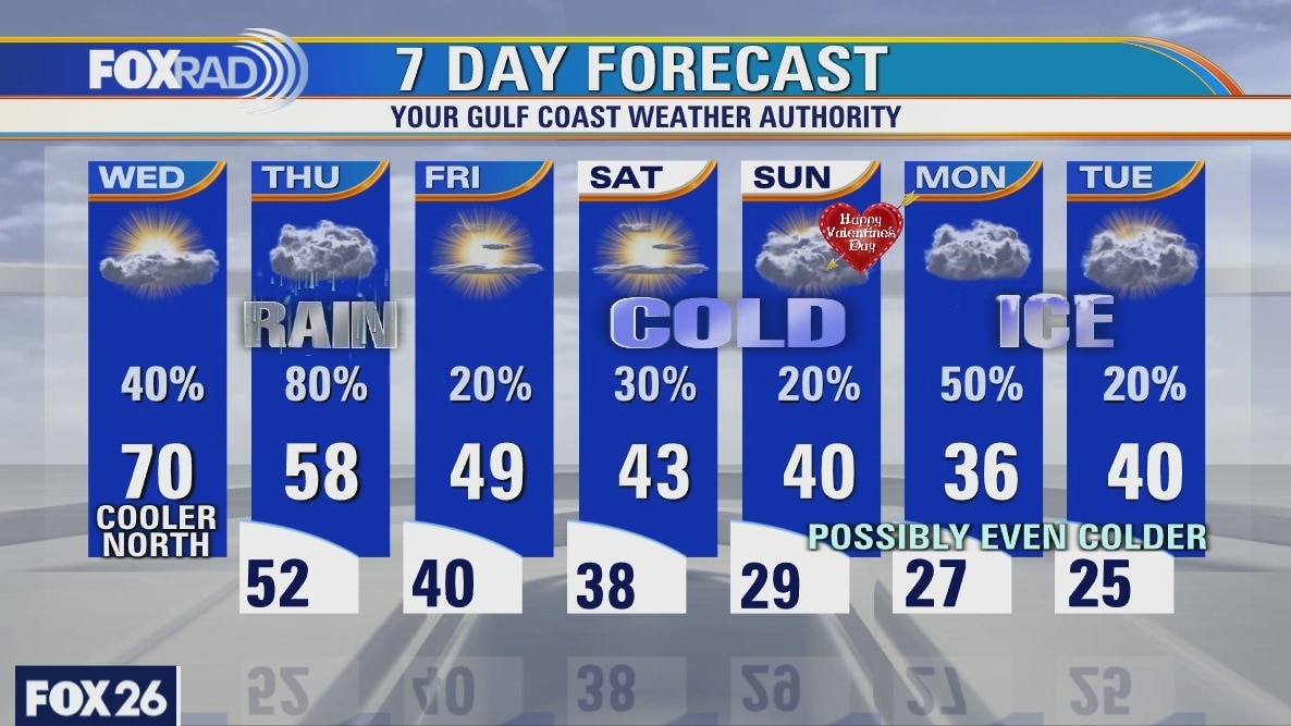
And so it begins...Cold air has arrived (slightly ahead of schedule) and will be with us for at least the next 10 days. Today is looking rainy, windy and cold with scattered t'storms mixed in. Small ice pellets are possible from Brenham to Huntsville. Tomorrow through Valentine's Day, expect cold air and light showers with some sleet/ice pellets possible. The biggest risk arrives in the form of freezing temps and lots of precip on Monday with icing likely. The coldest morning is likely Tuesday with teens and 20s likely.
And so it begins...Cold air has arrived (slightly ahead of schedule) and will be with us for at least the next 10 days. Today is looking rainy, windy and cold with scattered t'storms mixed in. Small ice pellets are possible from Brenham to Huntsville. Tomorrow through Valentine's Day, expect cold air and light showers with some sleet/ice pellets possible. The biggest risk arrives in the form of freezing temps and lots of precip on Monday with icing likely. The coldest morning is likely Tuesday with teens and 20s likely.
Thursday morning weather forecast
Rain is likely Thur and it gets cooler into the weekend. The freeze comes by Sat. night, but the coldest will be Sun-Tue. Freezing rain, sleet or snow will all be possible on President's Day on Mon. It will be very cold for SE Texas.
Rain is likely Thur and it gets cooler into the weekend. The freeze comes by Sat. night, but the coldest will be Sun-Tue. Freezing rain, sleet or snow will all be possible on President's Day on Mon. It will be very cold for SE Texas.
Wednesday Evening Weather Forecast
Rain is likely Thursday and it gets cooler into the weekend. The freeze comes by Saturday night, but the coldest will be Sunday - Tuesday. Freezing rain, sleet or snow will all be possible on President's Day on Monday. It will be very cold for SE Texas.
Rain is likely Thursday and it gets cooler into the weekend. The freeze comes by Saturday night, but the coldest will be Sunday - Tuesday. Freezing rain, sleet or snow will all be possible on President's Day on Monday. It will be very cold for SE Texas.
Wednesday weather forecast
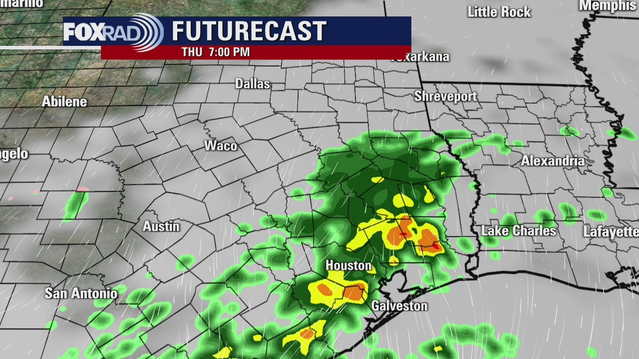
Watch for misty drizzle today with 50s and 60s to the north and 70s to the south. Thursday looks like a washout with highs in the 50s. Cold air moves in on Friday with highs only in the 40s. Beware from this weekend through the middle of next week, we're going to plunge some what could be the coldest air since January of 2018.
Watch for misty drizzle today with 50s and 60s to the north and 70s to the south. Thursday looks like a washout with highs in the 50s. Cold air moves in on Friday with highs only in the 40s. Beware from this weekend through the middle of next week, we're going to plunge some what could be the coldest air since January of 2018.

Wednesday morning weather forecast
The big chill will arrive over the weekend, but the cool-down will begin by Thursday. Yes, it will freeze overnight from Sunday night through Tuesday. Highs will only be in the 30s for those days too. That's very cold for SE Texas. It is still too early to know if we will see snow or freezing rain on Sunday or Monday.
The big chill will arrive over the weekend, but the cool-down will begin by Thursday. Yes, it will freeze overnight from Sunday night through Tuesday. Highs will only be in the 30s for those days too. That's very cold for SE Texas. It is still too early to know if we will see snow or freezing rain on Sunday or Monday.
Tuesday Evening Weather Forecast
Here's what we know about the coming cold snap. It arrives by Monday, it will freeze Sunday night through Tuesday and highs will be in the 30s starting Sunday. We don't know where or if we'll get freezing rain or snow yet. So stay tuned.
Here's what we know about the coming cold snap. It arrives by Monday, it will freeze Sunday night through Tuesday and highs will be in the 30s starting Sunday. We don't know where or if we'll get freezing rain or snow yet. So stay tuned.