

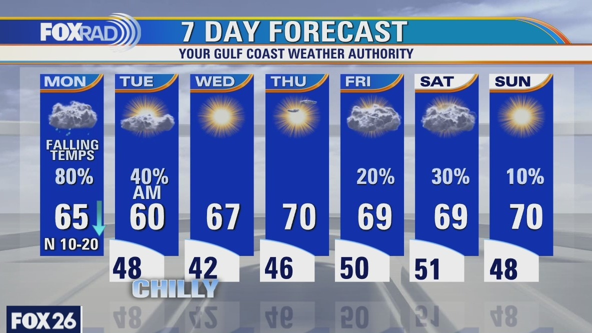
Monday weather forecast
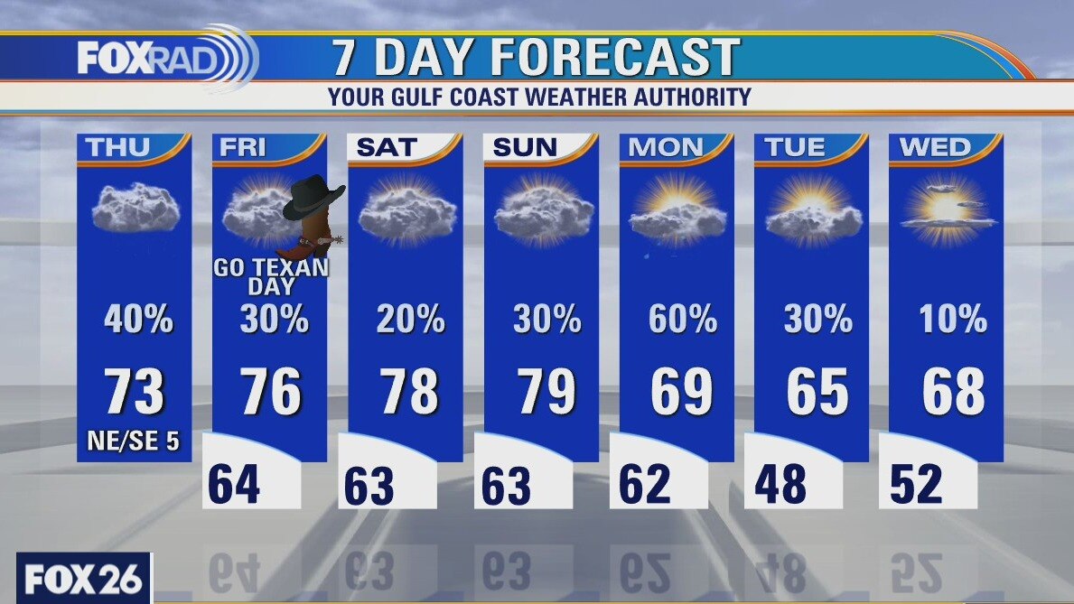
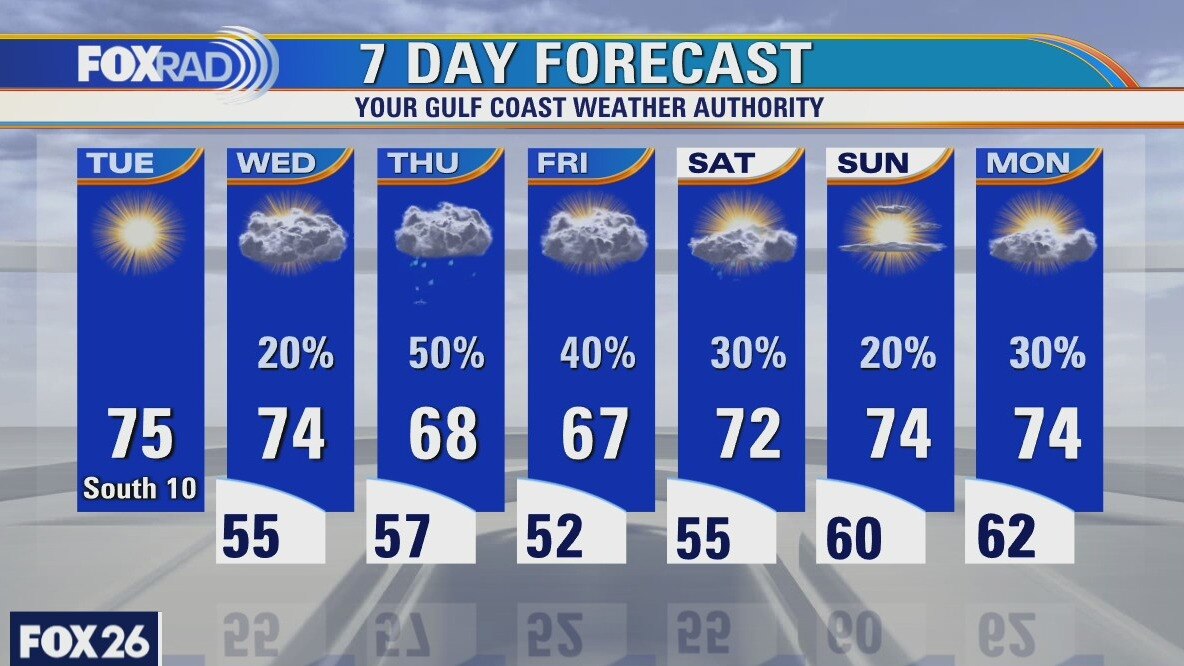
Following a high of 82 on Sunday, which was the warmest day since November, today's temperatures will fall into the 50s and 60s with cool winds and rain. Showers and storms should clear out by tomorrow morning leaving behind pleasant weather pattern for the rest of the week. Lows will drop into the 40s with highs in the upper 60s.
Following a high of 82 on Sunday, which was the warmest day since November, today's temperatures will fall into the 50s and 60s with cool winds and rain. Showers and storms should clear out by tomorrow morning leaving behind pleasant weather pattern for the rest of the week. Lows will drop into the 40s with highs in the upper 60s.
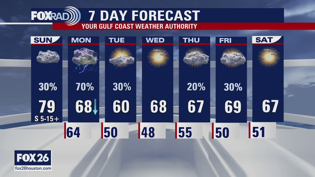
Houston-area weather forecast: February 28th
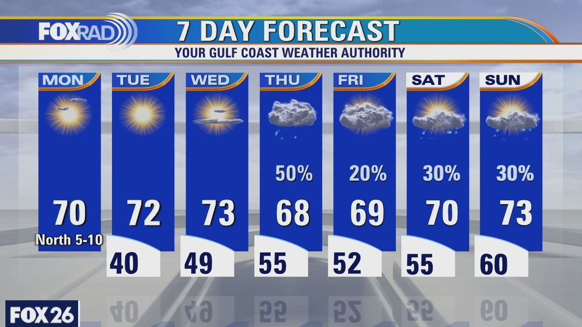
Many areas may not drop below 70 degrees this morning as we're starting off mild again. Dense sea fog continues along the coast where a dense fog advisory won't expire until 10AM. While a few light showers are possible today, a cold front will move through the area on Monday morning, clearing out the sea fog but bringing increased rain chances. Those rain chances will remain most of the day and might even linger into Tuesday. Highs, behind the cold front, won't be affected too much. We'll likely see a cooler day Monday and Tuesday, but see a decent rebound in those highs by Wednesday.
Many areas may not drop below 70 degrees this morning as we're starting off mild again. Dense sea fog continues along the coast where a dense fog advisory won't expire until 10AM. While a few light showers are possible today, a cold front will move through the area on Monday morning, clearing out the sea fog but bringing increased rain chances. Those rain chances will remain most of the day and might even linger into Tuesday. Highs, behind the cold front, won't be affected too much. We'll likely see a cooler day Monday and Tuesday, but see a decent rebound in those highs by Wednesday.
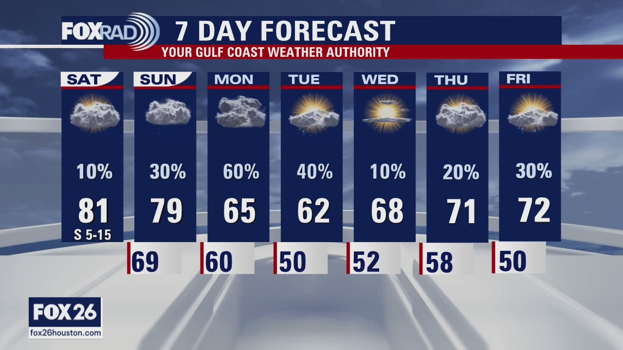
Saturday Weather Forecast
We're waking up to more sea fog along the coastline with mild temperatures everywhere else. Highs are expected to reach the upper 70s and low 80s again today, without much help from the sun as skies will remain mostly cloudy. A stray shower is possible on Saturday, but chances are unlikely. There's a better chance we see widespread showers on Sunday, especially on Sunday night as a cold front approaches. Monday will likely remain rainy, but conditions should improve as early as Tuesday afternoon.
We're waking up to more sea fog along the coastline with mild temperatures everywhere else. Highs are expected to reach the upper 70s and low 80s again today, without much help from the sun as skies will remain mostly cloudy. A stray shower is possible on Saturday, but chances are unlikely. There's a better chance we see widespread showers on Sunday, especially on Sunday night as a cold front approaches. Monday will likely remain rainy, but conditions should improve as early as Tuesday afternoon.
Saturday weather forecast
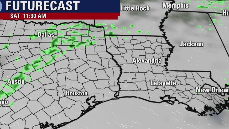
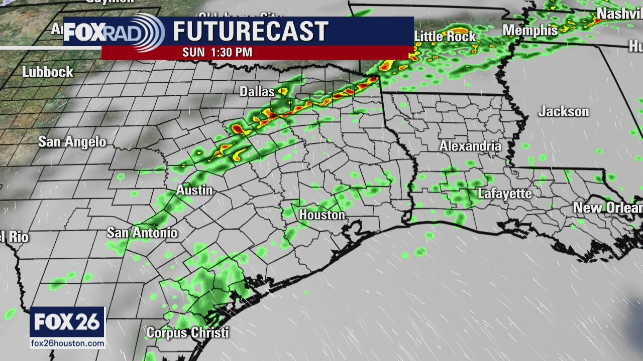
The weekend will be mild, humid and with a few lights showers. A front will arrive by early Monday and more organized rain and some thundershowers will be likely. Stronger storms will be likely up in North Texas, but not for the Houston area. It's a little cooler into the middle of the week, but it won't be too cold.
The weekend will be mild, humid and with a few lights showers. A front will arrive by early Monday and more organized rain and some thundershowers will be likely. Stronger storms will be likely up in North Texas, but not for the Houston area. It's a little cooler into the middle of the week, but it won't be too cold.
Mild, humid weekend ahead
The weekend will be mild, humid, and with a few light showers. A front will arrive by early Monday and more organized rain and some thundershowers will be likely. Stronger storms will be likely up in North Texas, but not for the Houston area. It's a little cooler into the middle of the week, but it won't be too cold.
The weekend will be mild, humid, and with a few light showers. A front will arrive by early Monday and more organized rain and some thundershowers will be likely. Stronger storms will be likely up in North Texas, but not for the Houston area. It's a little cooler into the middle of the week, but it won't be too cold.

Friday weather forecast
Depending on where you live, you may feel cooler air today, but most of the area will remain muggy. A stationary front does make for a complicated forecast today with highs in the upper 70s near and south of Houston and 60s to the north and west. Drizzle is likely today, but Saturday's rain chances do look lower. Expect a mild weekend followed by a front on Monday with showers and cooler air.
Depending on where you live, you may feel cooler air today, but most of the area will remain muggy. A stationary front does make for a complicated forecast today with highs in the upper 70s near and south of Houston and 60s to the north and west. Drizzle is likely today, but Saturday's rain chances do look lower. Expect a mild weekend followed by a front on Monday with showers and cooler air.
Friday morning weather forecast
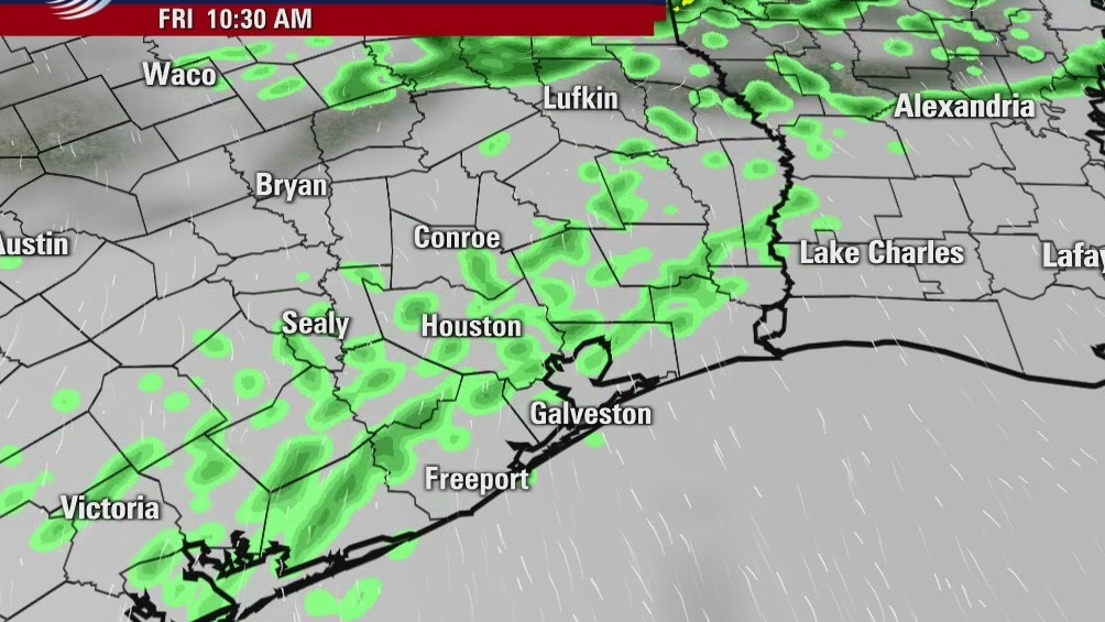
Look for patchy fog, cloudy skies and a few light showers on Friday. Highs will remain in the 70s over the weekend and so will a chance for light rain. It will be a somewhat grey and drizzly weekend. Monday will bring 60s for highs, a chance for thundershowers and a bit more organized rainfall.
Look for patchy fog, cloudy skies and a few light showers on Friday. Highs will remain in the 70s over the weekend and so will a chance for light rain. It will be a somewhat grey and drizzly weekend. Monday will bring 60s for highs, a chance for thundershowers and a bit more organized rainfall.

Fog and cloudy skies in the forecast
Look for patchy fog, cloudy skies and a few light showers on Friday. Highs will remain in the 70s over the weekend and so will a chance for light rain. It will be a somewhat grey and drizzly weekend. Monday will bring 60s for highs, a chance for thundershowers, and a bit more organized rainfall.
Look for patchy fog, cloudy skies and a few light showers on Friday. Highs will remain in the 70s over the weekend and so will a chance for light rain. It will be a somewhat grey and drizzly weekend. Monday will bring 60s for highs, a chance for thundershowers, and a bit more organized rainfall.
Thursday weather forecast
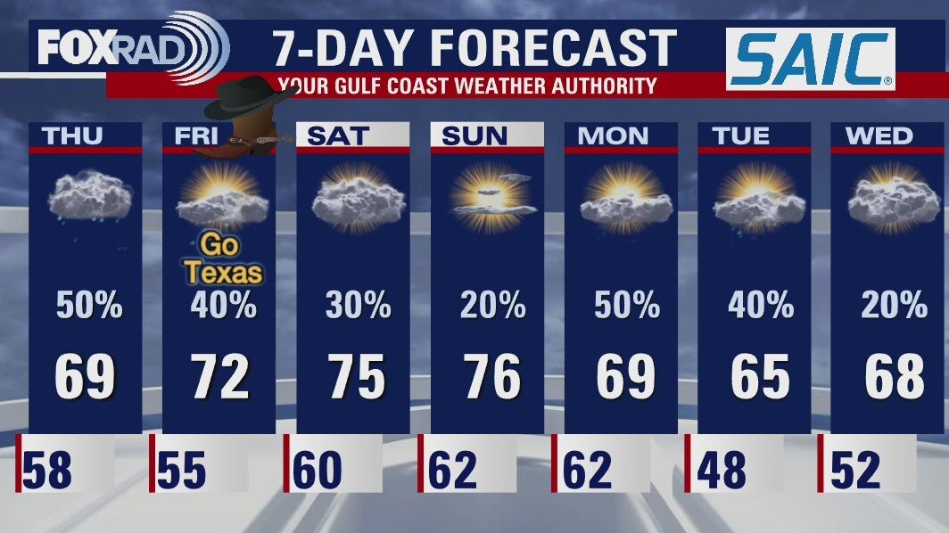
After another warm and humid morning, sea fog is forming, so watch for reduced visibilities along and near the coastline. Also, scattered showers are expected today as a front stalls just to our north. For tomorrow, which is Go Texan Day, more mild and muggy air with a few showers. The weekend looks pretty good, but with showers more likely on Sunday. A brief cooldown is on the way for early next week.
After another warm and humid morning, sea fog is forming, so watch for reduced visibilities along and near the coastline. Also, scattered showers are expected today as a front stalls just to our north. For tomorrow, which is Go Texan Day, more mild and muggy air with a few showers. The weekend looks pretty good, but with showers more likely on Sunday. A brief cooldown is on the way for early next week.
Thursday morning weather forecast
There will be a chance for rain every day over the coming week, but it may be more cloudy than soggy. Temps will remain in the upper 60s and 70s, so it won't be cold. Look for patchy fog especially along the coast and early in the mornings.
There will be a chance for rain every day over the coming week, but it may be more cloudy than soggy. Temps will remain in the upper 60s and 70s, so it won't be cold. Look for patchy fog especially along the coast and early in the mornings.
Wednesday Evening Weather Forecast
A Dense Fog Advisory is posted for SE Harris, Galveston and Chambers Counties until 9am Thursday. Visibilities will drop during the night as fog moves in from the Gulf. Watch for more fog in the forecast over the next several days. Most of the problems will be early in the morning hours along our coastal areas, but fog will be possible across SE Texas.
A Dense Fog Advisory is posted for SE Harris, Galveston and Chambers Counties until 9am Thursday. Visibilities will drop during the night as fog moves in from the Gulf. Watch for more fog in the forecast over the next several days. Most of the problems will be early in the morning hours along our coastal areas, but fog will be possible across SE Texas.
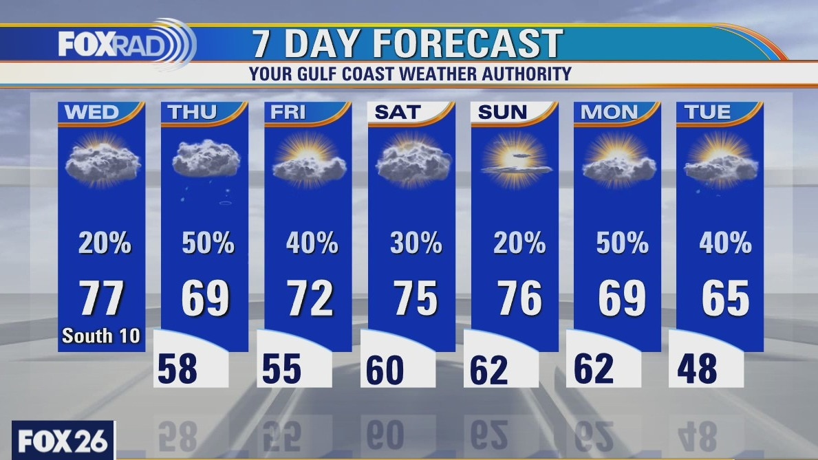
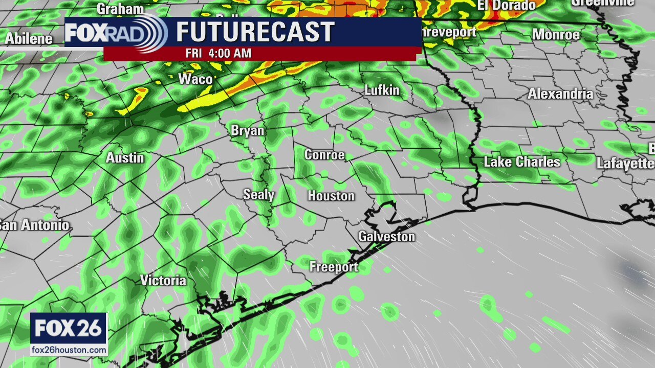
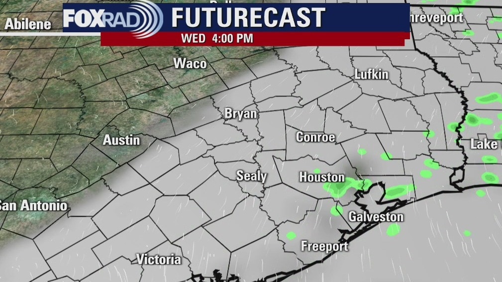
Wednesday weather forecast
Yesterday was the warmest day in nearly three weeks and that warming trend will continue today. Clouds and humidity will increase along with a few drizzles and highs in the upper 70s. Look for scattered showers with slightly cooler air on Thursday and then a return to a mild pattern for Friday and this weekend. Each day brings a chance for hit and miss showers.
Yesterday was the warmest day in nearly three weeks and that warming trend will continue today. Clouds and humidity will increase along with a few drizzles and highs in the upper 70s. Look for scattered showers with slightly cooler air on Thursday and then a return to a mild pattern for Friday and this weekend. Each day brings a chance for hit and miss showers.
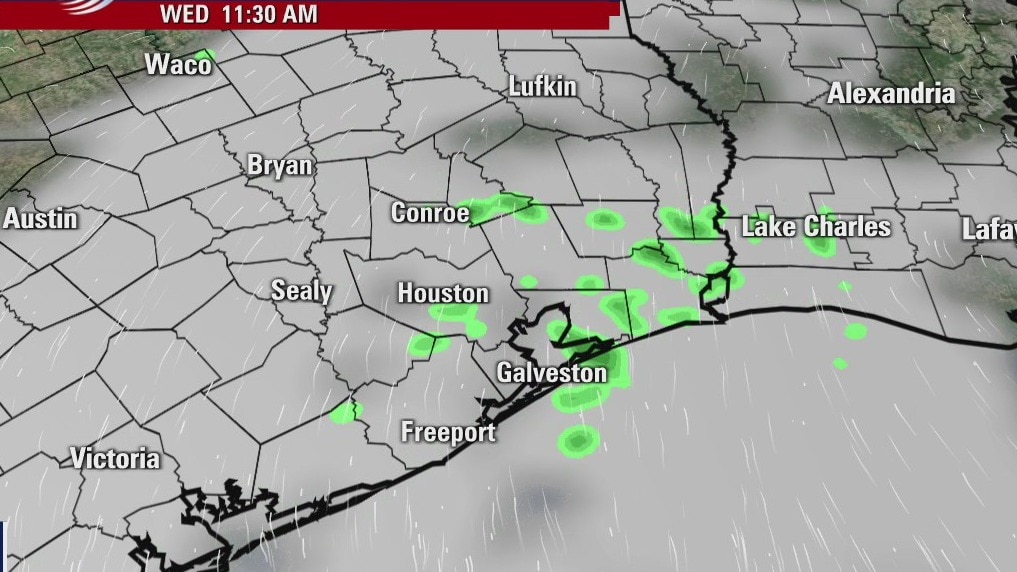
Wednesday morning weather forecast
Patchy fog will form along the coast early Wed. morning and our skies will become more cloudy. There may be a few on-and-off light showers during the day, but rain becomes more likely on Thur. as a weak front arrives. Highs will be in the 60s a couple of days before going back into the 70s over the weekend.
Patchy fog will form along the coast early Wed. morning and our skies will become more cloudy. There may be a few on-and-off light showers during the day, but rain becomes more likely on Thur. as a weak front arrives. Highs will be in the 60s a couple of days before going back into the 70s over the weekend.
Tuesday Evening Weather Forecast
Patchy fog will form along the coast early Wed. morning and our skies will become more cloudy. There may be a few on-and-off light showers during the day, but rain becomes more likely on Thur. as a weak front arrives. Highs will be in the 60s a couple of days before going back into the 70s over the weekend.
Patchy fog will form along the coast early Wed. morning and our skies will become more cloudy. There may be a few on-and-off light showers during the day, but rain becomes more likely on Thur. as a weak front arrives. Highs will be in the 60s a couple of days before going back into the 70s over the weekend.
Tuesday weather forecast
After a chilly morning, we'll warm up nicely today with highs back in the mid 70s. By the way, yesterday's highs were 50 degrees warmer than the previous Monday and today's highs will be roughly 40 degrees warmer than last Tuesday. Look for a few drizzles tomorrow, then scattered showers likely on Thursday. Luckily, our temperatures will remain above normal for at least the next week.
After a chilly morning, we'll warm up nicely today with highs back in the mid 70s. By the way, yesterday's highs were 50 degrees warmer than the previous Monday and today's highs will be roughly 40 degrees warmer than last Tuesday. Look for a few drizzles tomorrow, then scattered showers likely on Thursday. Luckily, our temperatures will remain above normal for at least the next week.
Monday Evening Weather Forecast
It will drop into the low 40s tonight, but the highs will be back into the 70s over the next two days. Some fog and rain chances will come mid-week, but the temps are not expected to cool much. The 70s will still be here over the weekend and a few showers as well.
It will drop into the low 40s tonight, but the highs will be back into the 70s over the next two days. Some fog and rain chances will come mid-week, but the temps are not expected to cool much. The 70s will still be here over the weekend and a few showers as well.
Monday weather forecast
One week ago, the power was going out and we were facing high temperatures in the 20s. This week looks much different, thank goodness. Look for low humidity and highs near 70 today. Tonight will be chilly, but above freezing. The rest of the week will remain mild with better rain chances beginning on Thursday. No freezing temperatures are expected for the next 7 days.
One week ago, the power was going out and we were facing high temperatures in the 20s. This week looks much different, thank goodness. Look for low humidity and highs near 70 today. Tonight will be chilly, but above freezing. The rest of the week will remain mild with better rain chances beginning on Thursday. No freezing temperatures are expected for the next 7 days.

Houston-area weather forecast: February 21
We?re waking up to temperatures in the 40s & 50s, but warming is expected throughout the afternoon. There?s a chance we?ll see highs near 70 today, but clouds might prevent us from warming too much. A cold front is set to arrive later tonight into Monday bringing a slight chance for showers. The front won?t set our temperatures back too much, though. By Wednesday, we?ll be making a run at 70 degrees before another front moves through Wednesday into Thursday.
We?re waking up to temperatures in the 40s & 50s, but warming is expected throughout the afternoon. There?s a chance we?ll see highs near 70 today, but clouds might prevent us from warming too much. A cold front is set to arrive later tonight into Monday bringing a slight chance for showers. The front won?t set our temperatures back too much, though. By Wednesday, we?ll be making a run at 70 degrees before another front moves through Wednesday into Thursday.

Houston-area weather forecast: February 20th
Our final freeze of this long cold snap is now in the history books as we?ll be warming into the upper 50s today and not dropping down to the freezing mark again (or at least in the near future). In fact on Sunday, after starting in the low and mid 40s, we may see a few spots reach 70 degrees. A cold front will move through the area late Sunday night into Monday, bringing a slight chance for showers. While temperatures might be slightly cooler on Monday, we?ll likely warm into the 70s by Wednesday.
Our final freeze of this long cold snap is now in the history books as we?ll be warming into the upper 50s today and not dropping down to the freezing mark again (or at least in the near future). In fact on Sunday, after starting in the low and mid 40s, we may see a few spots reach 70 degrees. A cold front will move through the area late Sunday night into Monday, bringing a slight chance for showers. While temperatures might be slightly cooler on Monday, we?ll likely warm into the 70s by Wednesday.
Saturday morning weather forecast
Temperatures will be freezing for most areas of Southeast Texas tonight, but the hard freeze will remain north and west of Houston. Highs on Saturday will reach the middle 50s and with the sunshine it will feel very nice. By Sunday we will be back in the 60s.
Temperatures will be freezing for most areas of Southeast Texas tonight, but the hard freeze will remain north and west of Houston. Highs on Saturday will reach the middle 50s and with the sunshine it will feel very nice. By Sunday we will be back in the 60s.