

Houston-area weather forecast: April 18th
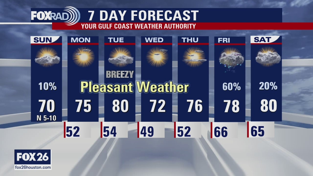
Temperatures are several degrees cooler this morning than even Saturday morning, but with a partly cloudy sky we should warm well into the 60s and low 70s this afternoon. A stray coastal shower will be possible, but most of the area should remain dry on Sunday. We?ll be cool, once again, this evening but gradually warm through Tuesday until another cold front moves through the area on Tuesday. The front won?t produce any rain, but will bring a reinforcing shot of cooler air for Wednesday and Thursday. Next rain chance arrives Friday.
Temperatures are several degrees cooler this morning than even Saturday morning, but with a partly cloudy sky we should warm well into the 60s and low 70s this afternoon. A stray coastal shower will be possible, but most of the area should remain dry on Sunday. We?ll be cool, once again, this evening but gradually warm through Tuesday until another cold front moves through the area on Tuesday. The front won?t produce any rain, but will bring a reinforcing shot of cooler air for Wednesday and Thursday. Next rain chance arrives Friday.

Houston-area weather forecast: April 17th
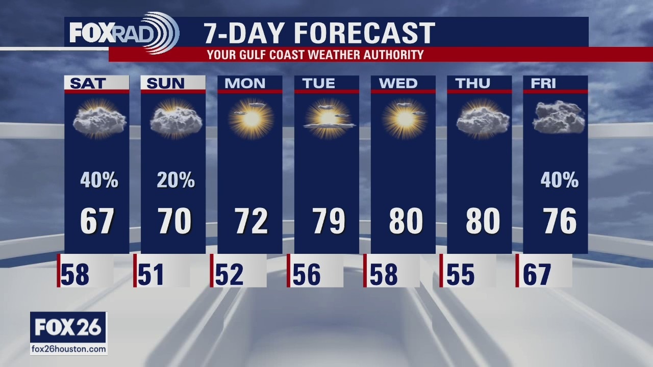
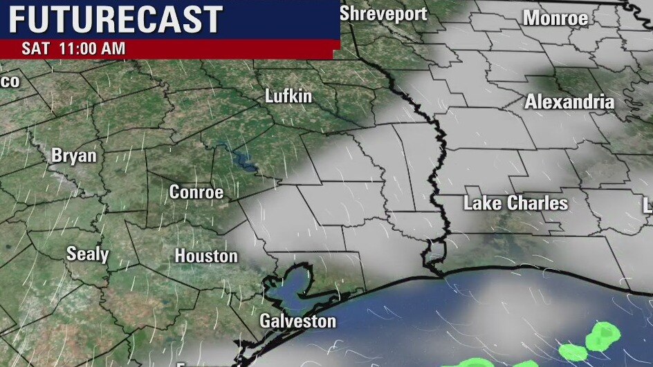
We?re starting off cool on this Saturday morning and gloomy weather will likely persist throughout the day. Rain chances will increase later this morning into the afternoon as temperatures hover in the mid and upper 60s. It?ll also be rather breezy today, too. Drier air is expected to filter in on Sunday and rain chances will also begin to drop. Highs on Sunday will likely be a few degrees warmer and that warming trend will continue into the work week.
We?re starting off cool on this Saturday morning and gloomy weather will likely persist throughout the day. Rain chances will increase later this morning into the afternoon as temperatures hover in the mid and upper 60s. It?ll also be rather breezy today, too. Drier air is expected to filter in on Sunday and rain chances will also begin to drop. Highs on Sunday will likely be a few degrees warmer and that warming trend will continue into the work week.
Saturday morning weather forecast
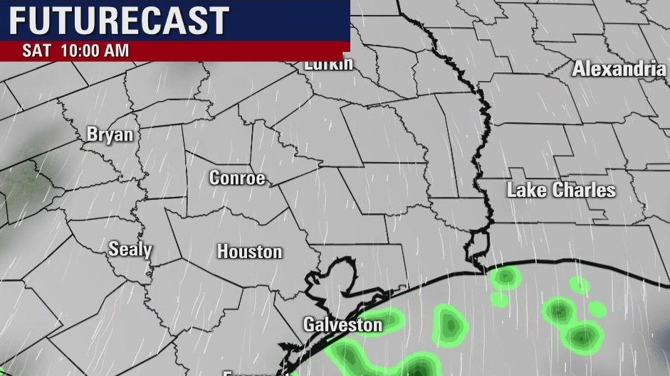
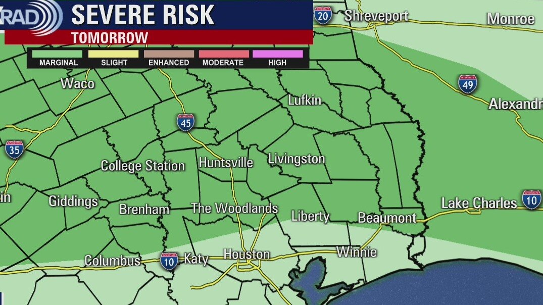
There is a marginal risk for areas north of Houston for a few strong to severe storms on Friday. The rest of SE Texas can expect normal types of showers. A front will arrive by early Saturday and that will help drop the risk for severe weather. The weekend looks a bit cooler and there will be a few showers at different times.
There is a marginal risk for areas north of Houston for a few strong to severe storms on Friday. The rest of SE Texas can expect normal types of showers. A front will arrive by early Saturday and that will help drop the risk for severe weather. The weekend looks a bit cooler and there will be a few showers at different times.
Friday evening weather forecast
A cold front will move through Friday night and it will be cooler over the weekend. There will be some showers on Saturday, but nothing severe for SE Texas. Some minor disturbances will move across the region during the day, which will cause scattered showers. The coming week looks drier and with more sunshine at least until Thursday.
A cold front will move through Friday night and it will be cooler over the weekend. There will be some showers on Saturday, but nothing severe for SE Texas. Some minor disturbances will move across the region during the day, which will cause scattered showers. The coming week looks drier and with more sunshine at least until Thursday.
Friday weather forecast
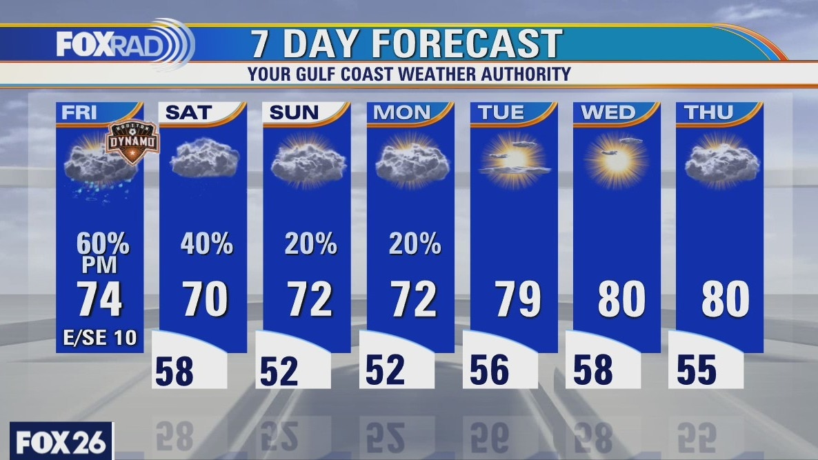
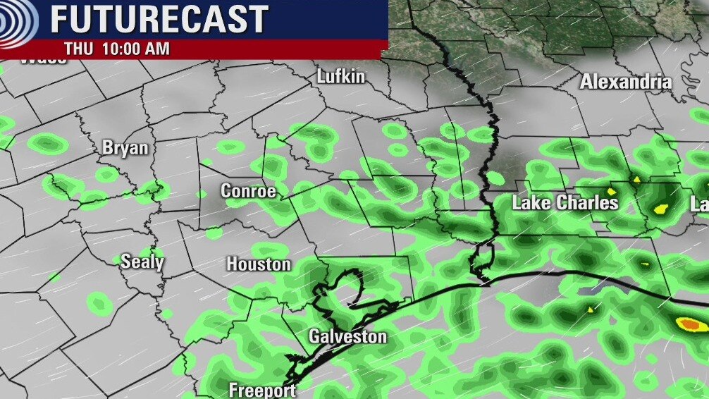
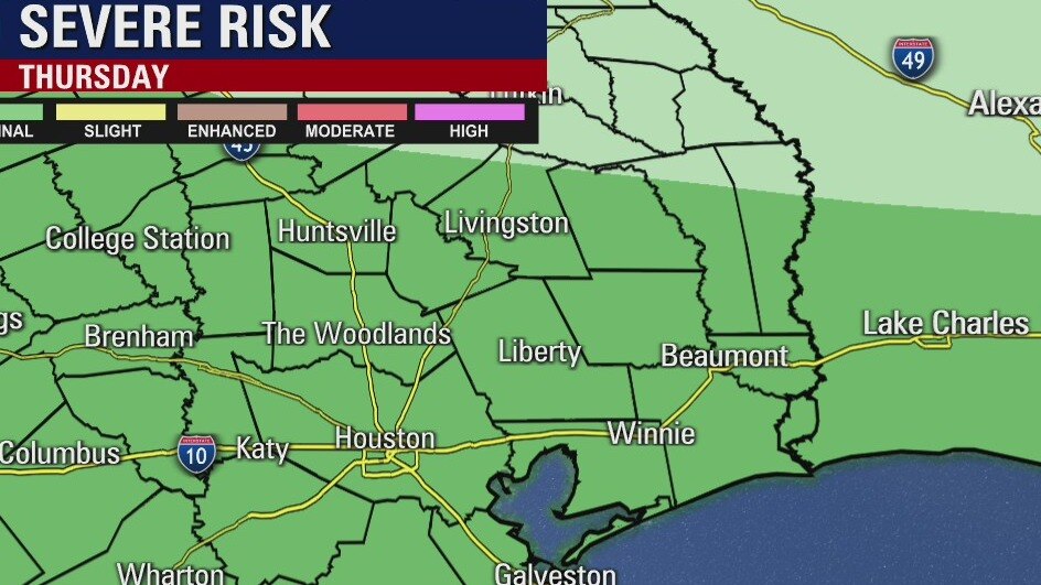
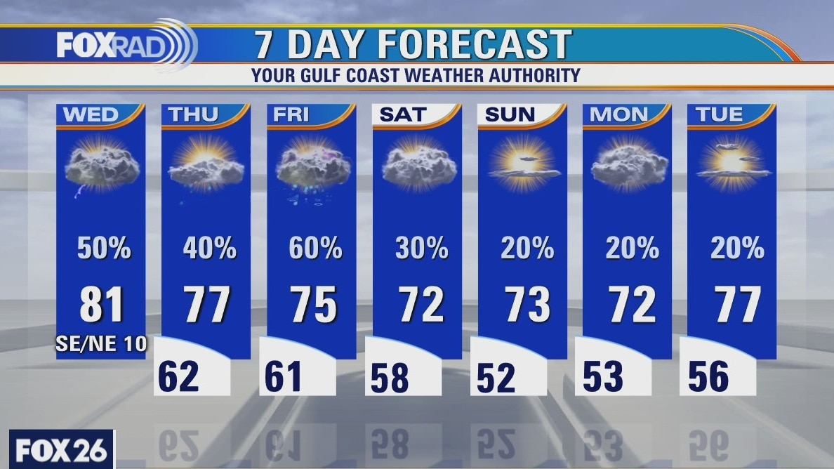
Following a brief round of severe storms in spots last night, today will bring a good chance for late day and evening storms as another cool front approaches. Look for scattered storms after mid-afternoon, then the potential for showers Saturday. A cooler, drier pattern sets up beginning Sunday with lows in the low 50s.
Following a brief round of severe storms in spots last night, today will bring a good chance for late day and evening storms as another cool front approaches. Look for scattered storms after mid-afternoon, then the potential for showers Saturday. A cooler, drier pattern sets up beginning Sunday with lows in the low 50s.
Thursday evening weather forecast
There is a marginal risk for areas north of Houston for a few strong to severe storms on Friday. The rest of SE Texas can expect normal types of showers. A front will arrive by early Saturday and that will help drop the risk for severe weather. The weekend looks a bit cooler and there will be a few showers at different times.
There is a marginal risk for areas north of Houston for a few strong to severe storms on Friday. The rest of SE Texas can expect normal types of showers. A front will arrive by early Saturday and that will help drop the risk for severe weather. The weekend looks a bit cooler and there will be a few showers at different times.

Thursday weather forecast
It's looking like a cloudy and breezy day with a chance for scattered showers or a few storms by late today. Temps will also run about 5 degrees cooler today. Watch for another round of storms Friday followed by a pleasant cool down this weekend with lows in the low 50s.
It's looking like a cloudy and breezy day with a chance for scattered showers or a few storms by late today. Temps will also run about 5 degrees cooler today. Watch for another round of storms Friday followed by a pleasant cool down this weekend with lows in the low 50s.
Thursday morning weather forecast
Showers and some storms are possible through Friday, but tonight may have the higher risk for strong storms and that is mainly near the coast. The rain on Friday looks to be during the early half of the day and tapering off into the afternoon. Temps look cooler next week with highs in the 70s and lows in the 40s and 50s for a few days.
Showers and some storms are possible through Friday, but tonight may have the higher risk for strong storms and that is mainly near the coast. The rain on Friday looks to be during the early half of the day and tapering off into the afternoon. Temps look cooler next week with highs in the 70s and lows in the 40s and 50s for a few days.
Wednesday evening weather forecast
Showers and some storms are possible through Friday, but tonight may have the higher risk for strong storms and that is mainly near the coast. The rain on Friday looks to be during the early half of the day and tapering off into the afternoon. Temps look cooler next week with highs in the 70s and lows in the 40s and 50s for a few days.
Showers and some storms are possible through Friday, but tonight may have the higher risk for strong storms and that is mainly near the coast. The rain on Friday looks to be during the early half of the day and tapering off into the afternoon. Temps look cooler next week with highs in the 70s and lows in the 40s and 50s for a few days.
Wednesday weather forecast
Breezy and mild this morning with isolated showers, then sct?d storms with highs in the low 80s.
Breezy and mild this morning with isolated showers, then sct?d storms with highs in the low 80s.
Wednesday morning weather forecast
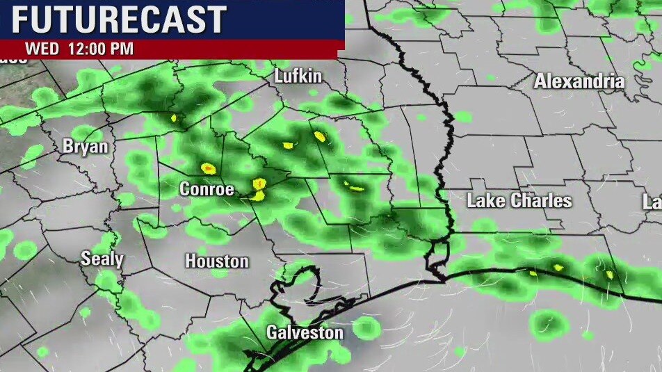
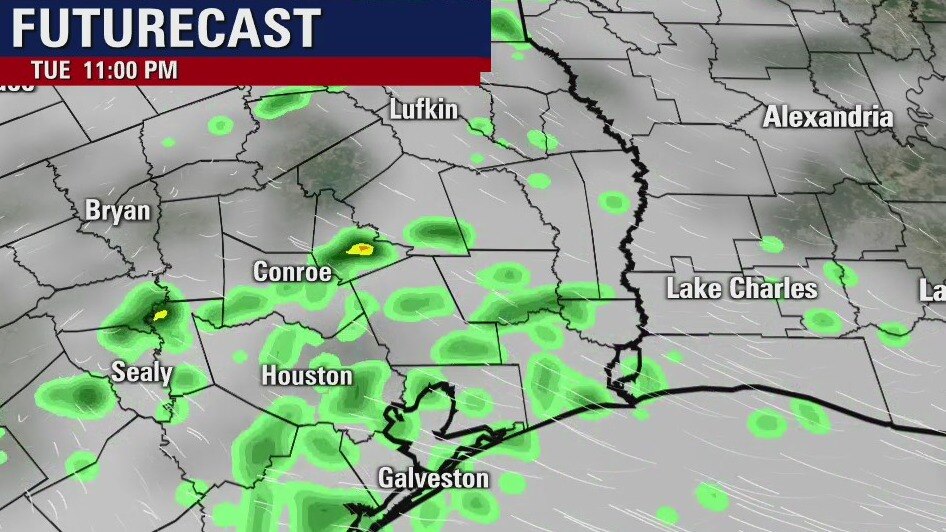
There is a chance for rain and maybe some strong storms from Wed. night through Friday night. Overall, the good thing is we need the rain and we will keep an eye out of any severe weather. SE Texas will have a weak front stall along the coast and some minor disturbances will move across the area. It mostly looks like normal showers with a few stronger ones mixed in from time-to-time. Temps will be a little cooler going into next week.
There is a chance for rain and maybe some strong storms from Wed. night through Friday night. Overall, the good thing is we need the rain and we will keep an eye out of any severe weather. SE Texas will have a weak front stall along the coast and some minor disturbances will move across the area. It mostly looks like normal showers with a few stronger ones mixed in from time-to-time. Temps will be a little cooler going into next week.
Tuesday evening weather forecast
There is a chance for rain and maybe some strong storms from Wed. night through Friday night. Overall, the good thing is we need the rain and we will keep an eye out of any severe weather. SE Texas will have a weak front stall along the coast and some minor disturbances will move across the area. It mostly looks like normal showers with a few stronger ones mixed in from time-to-time. Temps will be a little cooler going into next week.
There is a chance for rain and maybe some strong storms from Wed. night through Friday night. Overall, the good thing is we need the rain and we will keep an eye out of any severe weather. SE Texas will have a weak front stall along the coast and some minor disturbances will move across the area. It mostly looks like normal showers with a few stronger ones mixed in from time-to-time. Temps will be a little cooler going into next week.

Tuesday weather forecast
After a muggy, drizzly morning, watch for sct'd storms today and tonight with a few strong ones that could produce hail. We'll have a pretty good chance for showers and storms each day this week with a possible cool down by this weekend.
After a muggy, drizzly morning, watch for sct'd storms today and tonight with a few strong ones that could produce hail. We'll have a pretty good chance for showers and storms each day this week with a possible cool down by this weekend.
Tuesday morning weather forecast
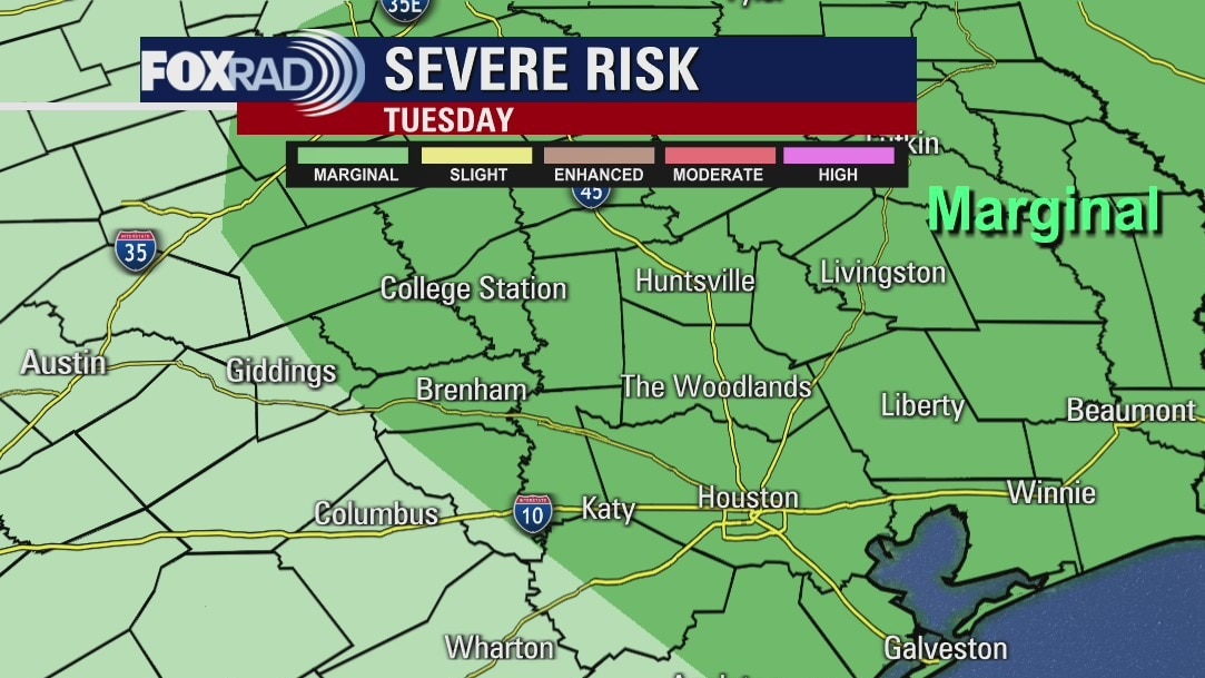
There's a daily chance for rain this week, but the best risk for more organized storms will be late Tuesday into Wednesday and again on Friday. There's a marginal risk for severe storms, which means we are not expecting a large outbreak of strong storms. The area could use some nice rain as SE Texas is included with large areas of central and western Texas that are under drought conditions.
There's a daily chance for rain this week, but the best risk for more organized storms will be late Tuesday into Wednesday and again on Friday. There's a marginal risk for severe storms, which means we are not expecting a large outbreak of strong storms. The area could use some nice rain as SE Texas is included with large areas of central and western Texas that are under drought conditions.
Monday evening weather forecast
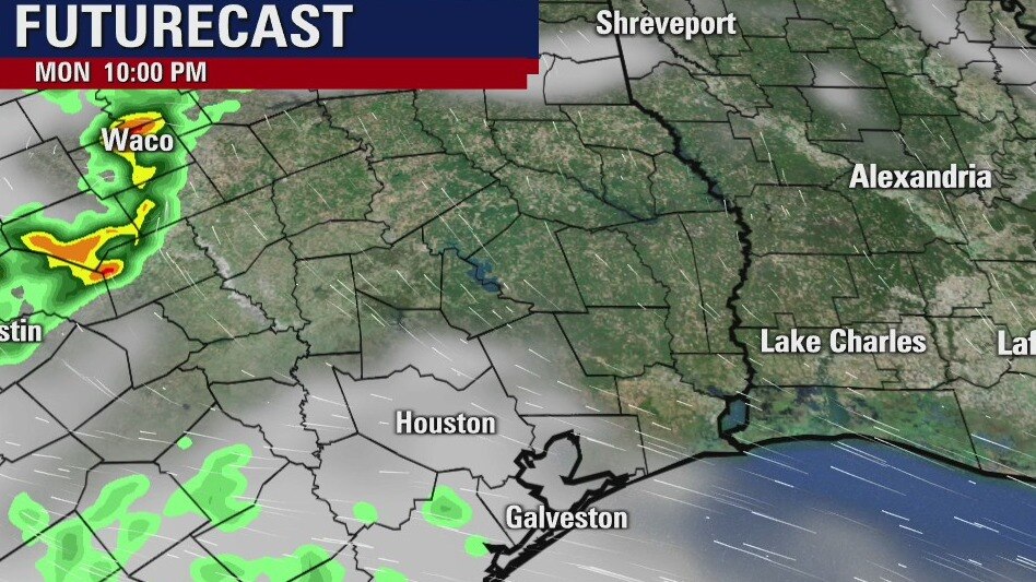
There's a daily chance for rain this week, but the best risk for more organized storms will be late Tuesday into Wednesday and again on Friday. There's a marginal risk for severe storms, which means we are not expecting a large outbreak of strong storms. The area could use some nice rain as SE Texas is included with large areas of central and western Texas that are under drought conditions.
There's a daily chance for rain this week, but the best risk for more organized storms will be late Tuesday into Wednesday and again on Friday. There's a marginal risk for severe storms, which means we are not expecting a large outbreak of strong storms. The area could use some nice rain as SE Texas is included with large areas of central and western Texas that are under drought conditions.
Monday weather forecast
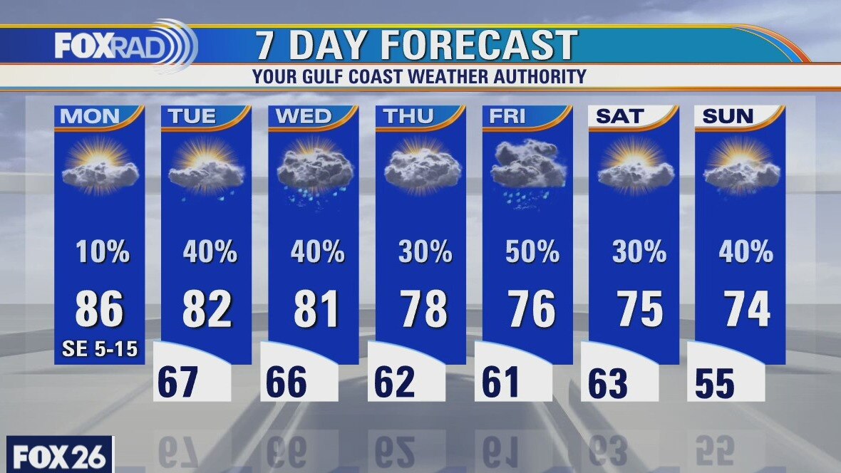
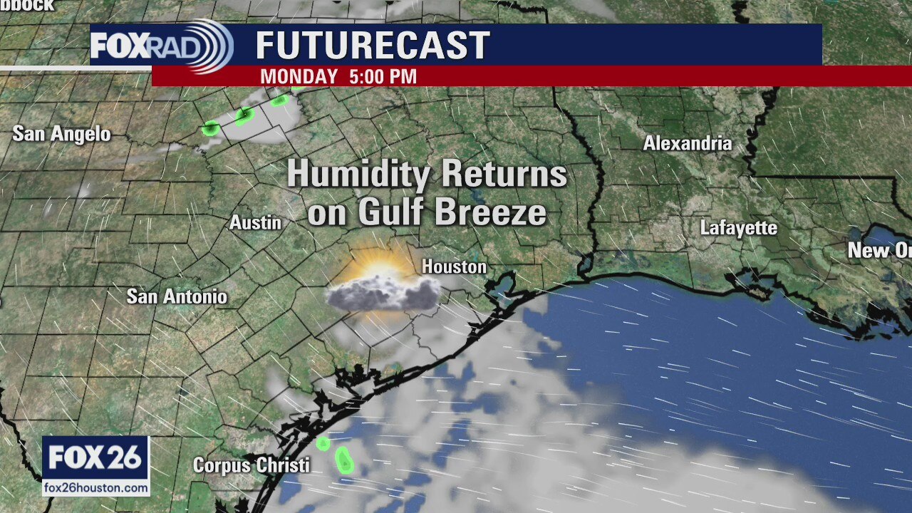
Watch for early morning fog today as moisture slowly returns from the Gulf. Other than a few small showers, today should be pretty quiet with highs in the mid 80s. Drizzle could return as early as tonight and usher in a pattern with a daily round of showers and storms through the weekend. The rain is much needed because 3/4 of Texas is under drought conditions including most of our area.
Watch for early morning fog today as moisture slowly returns from the Gulf. Other than a few small showers, today should be pretty quiet with highs in the mid 80s. Drizzle could return as early as tonight and usher in a pattern with a daily round of showers and storms through the weekend. The rain is much needed because 3/4 of Texas is under drought conditions including most of our area.
Monday Morning Weather Forecast
Meteorologist John Dawson gives you a preview to how the beginning of the work week will look like.
Meteorologist John Dawson gives you a preview to how the beginning of the work week will look like.

Sunday Morning Weather Forecast
The sunny and dry weekend continues for Southeast Texas. Houston will enjoy low humidity for most of Sunday before the winds shift back to the Gulf towards the end of the day. Mild mornings return on Monday with hit-or-miss showers starting on Tuesday.
The sunny and dry weekend continues for Southeast Texas. Houston will enjoy low humidity for most of Sunday before the winds shift back to the Gulf towards the end of the day. Mild mornings return on Monday with hit-or-miss showers starting on Tuesday.
Saturday morning weather forecast
Showers are possible tonight and early Saturday, and while severe storms will be likely in nearby states, it looks more quiet for SE Texas and Houston. The weekend will be drier and sunny, but the humidity will be back by early next week. It will be breezy on Saturday, but less windy on Sunday.
Showers are possible tonight and early Saturday, and while severe storms will be likely in nearby states, it looks more quiet for SE Texas and Houston. The weekend will be drier and sunny, but the humidity will be back by early next week. It will be breezy on Saturday, but less windy on Sunday.

Friday evening weather forecast
Showers are possible tonight and early Saturday, and while severe storms will be likely in nearby states, it looks more quiet for SE Texas and Houston. The weekend will be drier and sunny, but the humidity will be back by early next week. It will be breezy on Saturday, but less windy on Sunday.
Showers are possible tonight and early Saturday, and while severe storms will be likely in nearby states, it looks more quiet for SE Texas and Houston. The weekend will be drier and sunny, but the humidity will be back by early next week. It will be breezy on Saturday, but less windy on Sunday.