

Friday morning weather forecast with Meteorologist John Dawson
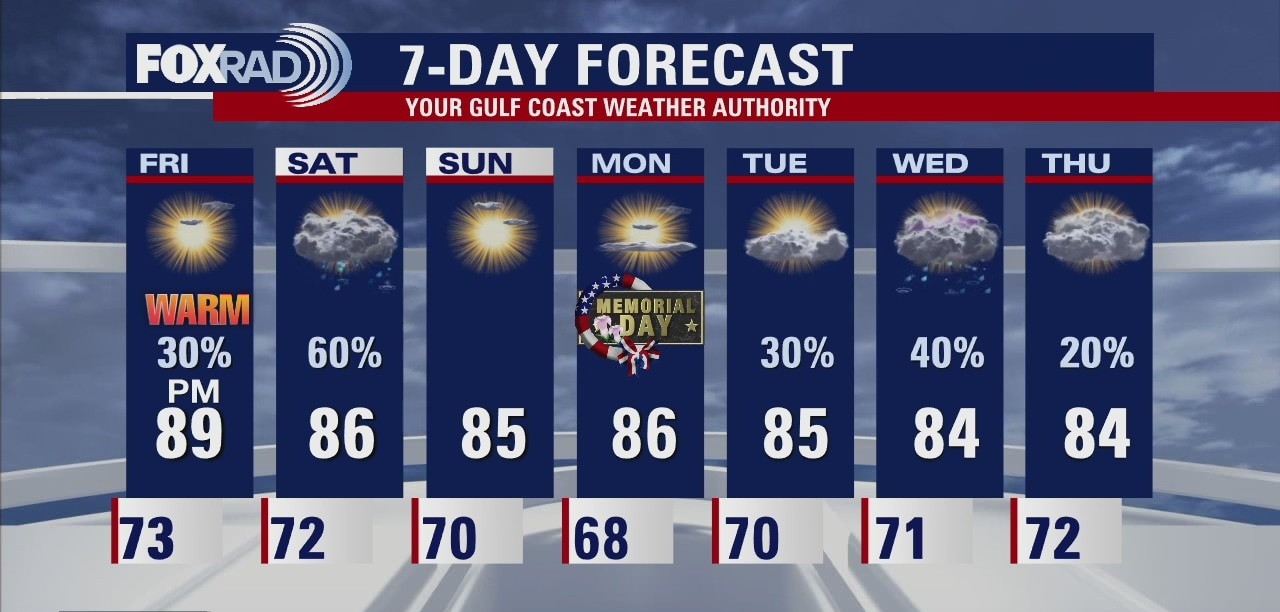
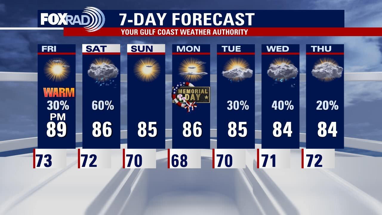
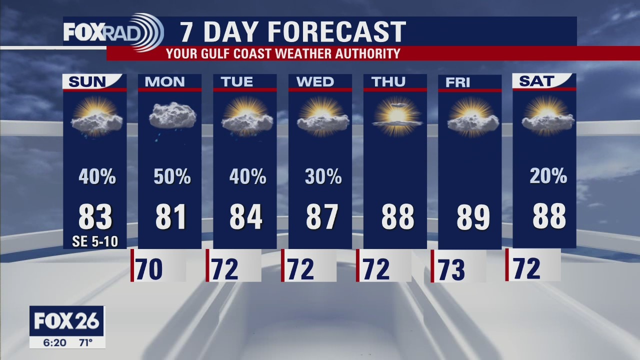
Get ready for another warm day around Southeast Texas on Friday. Look for some late-day storms to move into the area as a front approaches. That front will keep rain chances around for Saturday. Behind the front skies clear and Houston should enjoy a nice end to the holiday weekend with great weather to be outdoors on Sunday and Monday.
Get ready for another warm day around Southeast Texas on Friday. Look for some late-day storms to move into the area as a front approaches. That front will keep rain chances around for Saturday. Behind the front skies clear and Houston should enjoy a nice end to the holiday weekend with great weather to be outdoors on Sunday and Monday.
Thursday evening weather forecast with Meteorologist John Dawson
Get ready for another warm day around Southeast Texas on Friday. Look for some late-day storms to move into the area as a front approaches. That front will keep rain chances around for Saturday. Behind the front skies clear and Houston should enjoy a nice end to the holiday weekend with great weather to be outdoors on Sunday and Monday.
Get ready for another warm day around Southeast Texas on Friday. Look for some late-day storms to move into the area as a front approaches. That front will keep rain chances around for Saturday. Behind the front skies clear and Houston should enjoy a nice end to the holiday weekend with great weather to be outdoors on Sunday and Monday.
Thursday weather forecast
Morning fog followed by a mostly to partly cloudy sky. Isolated showers possible in the afternoon. Highs in the mid 80s.
Morning fog followed by a mostly to partly cloudy sky. Isolated showers possible in the afternoon. Highs in the mid 80s.
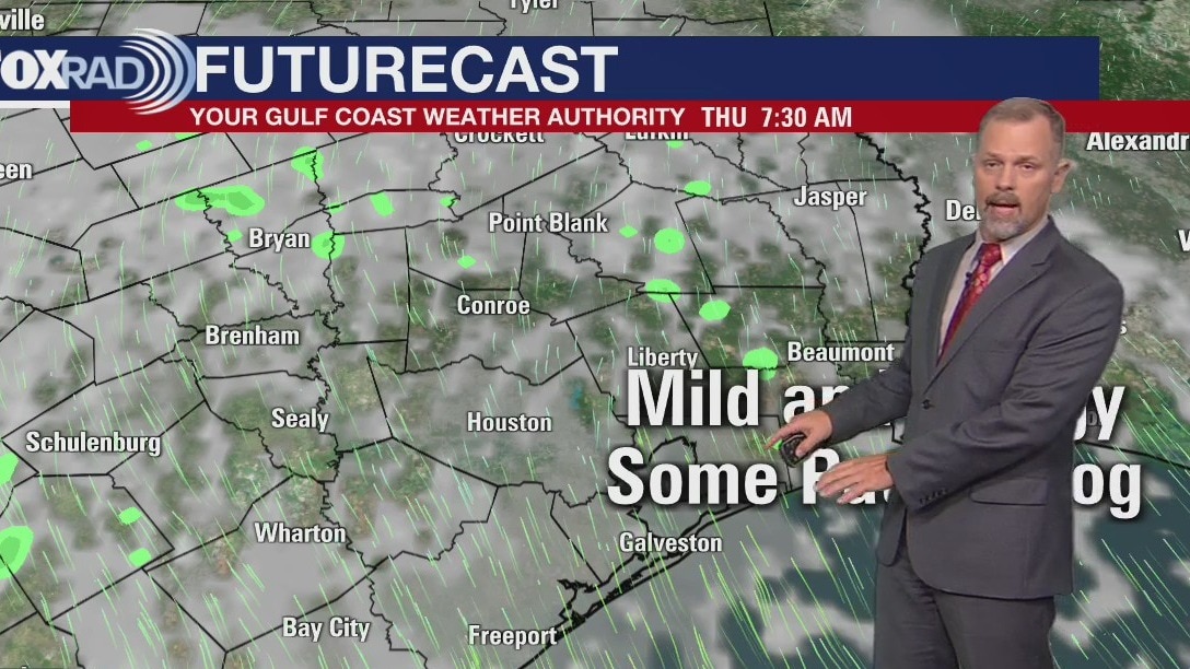
Thursday morning weather forecast
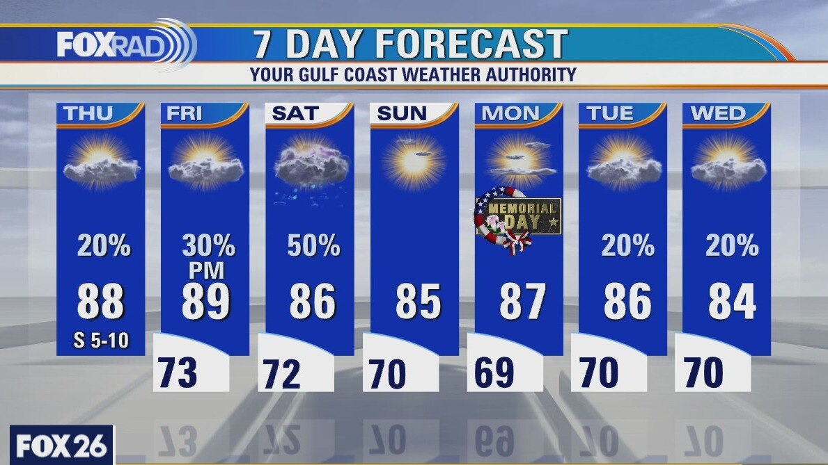
Southeast Texas is moving into a drier pattern, a welcomed break from several rainy days. Look for warm afternoons to end the work week with mild mornings. Rain chances return on Saturday as a front drags across the area. High pressure builds in on Sunday ending the holiday weekend with some great outdoors weather.
Southeast Texas is moving into a drier pattern, a welcomed break from several rainy days. Look for warm afternoons to end the work week with mild mornings. Rain chances return on Saturday as a front drags across the area. High pressure builds in on Sunday ending the holiday weekend with some great outdoors weather.
Wednesday evening weather forecast
The heat is making a comeback with temperatures in the 80s, but it'll feel like the 90s. Meteorologist John Dawson has more with your FOX 26 Weather.
The heat is making a comeback with temperatures in the 80s, but it'll feel like the 90s. Meteorologist John Dawson has more with your FOX 26 Weather.
Wednesday weather forecast
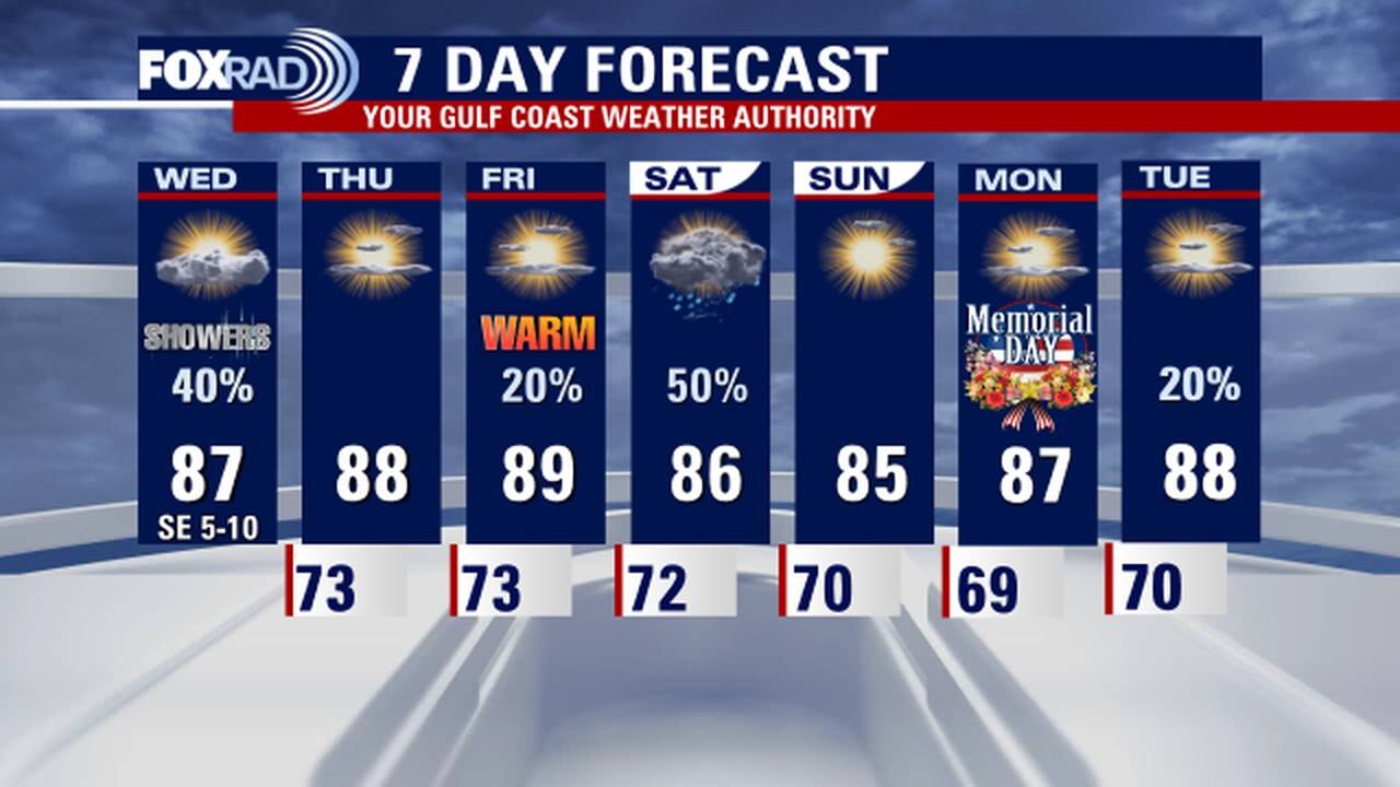
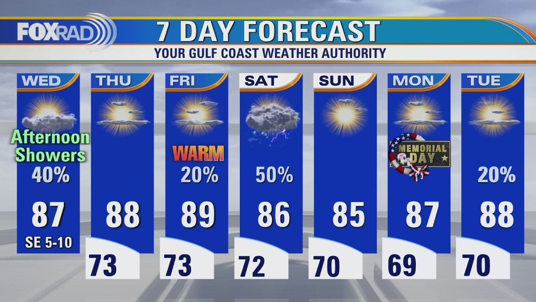
Rain in the forecast again for Wednesday but the intensity and the coverage should be less than what we?ve seen in the last few days. It will be warmer and drier at the end of the work week. The holiday weekend could see some showers/storms on Saturday but Sunday and Monday should be better for outdoor activities.
Rain in the forecast again for Wednesday but the intensity and the coverage should be less than what we?ve seen in the last few days. It will be warmer and drier at the end of the work week. The holiday weekend could see some showers/storms on Saturday but Sunday and Monday should be better for outdoor activities.
Wednesday morning weather forecast
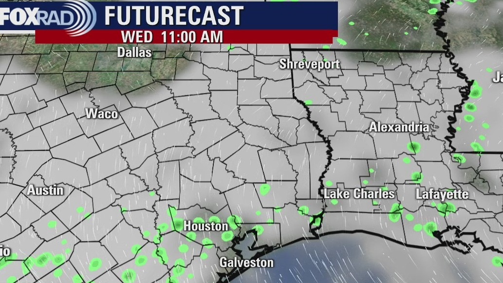
Showers will be in the forecast for Wednesday, but they are expected to be a little less intense or widespread. The rest of the week is closer to normal with warm temps and some pop-up showers every now and then. It will also be very humid.
Showers will be in the forecast for Wednesday, but they are expected to be a little less intense or widespread. The rest of the week is closer to normal with warm temps and some pop-up showers every now and then. It will also be very humid.

Tuesday evening weather forecast
Showers will be in the forecast for Wednesday, but they are expected to be a little less intense or widespread. The rest of the week is closer to normal with warm temps and some pop-up showers every now and then. It will also be very humid.
Showers will be in the forecast for Wednesday, but they are expected to be a little less intense or widespread. The rest of the week is closer to normal with warm temps and some pop-up showers every now and then. It will also be very humid.
Tuesday weather forecast
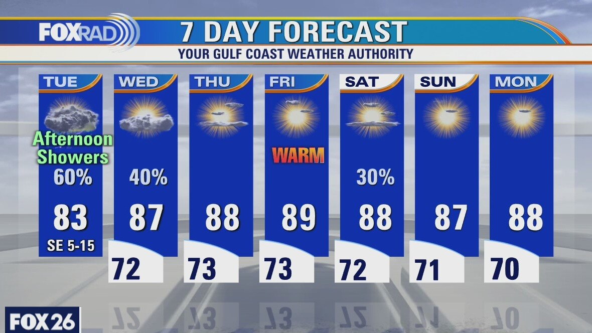
A Flash Flood Watch continues for most of the Houston area on Tuesday as afternoon storms are expected to return. Most will see an inch or less of rain but isolated spots that receive 2-3 inches could result in flooding. The end of the week will be drier with the return of the sun. Temperatures return to the upper 80s.
A Flash Flood Watch continues for most of the Houston area on Tuesday as afternoon storms are expected to return. Most will see an inch or less of rain but isolated spots that receive 2-3 inches could result in flooding. The end of the week will be drier with the return of the sun. Temperatures return to the upper 80s.
Tuesday morning weather forecast
Rain will again be likely on Tuesday as more moisture moves across the region from the Gulf. Daytime heating will help fire off more scattered heavy downpours. It will dry a little by the middle of the week and rain chances will drop down to 20% and we can expect more sunshine by the holiday weekend. Stay alert and safe out there.
Rain will again be likely on Tuesday as more moisture moves across the region from the Gulf. Daytime heating will help fire off more scattered heavy downpours. It will dry a little by the middle of the week and rain chances will drop down to 20% and we can expect more sunshine by the holiday weekend. Stay alert and safe out there.
Monday evening weather forecast
Rain will again be likely on Tuesday as more moisture moves across the region from the Gulf. Daytime heating will help fire off more scattered heavy downpours. It will dry a little by the middle of the week and rain chances will drop down to 20% and we can expect more sunshine by the holiday weekend. Stay alert and safe out there.
Rain will again be likely on Tuesday as more moisture moves across the region from the Gulf. Daytime heating will help fire off more scattered heavy downpours. It will dry a little by the middle of the week and rain chances will drop down to 20% and we can expect more sunshine by the holiday weekend. Stay alert and safe out there.
Monday weather forecast
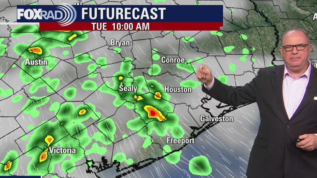
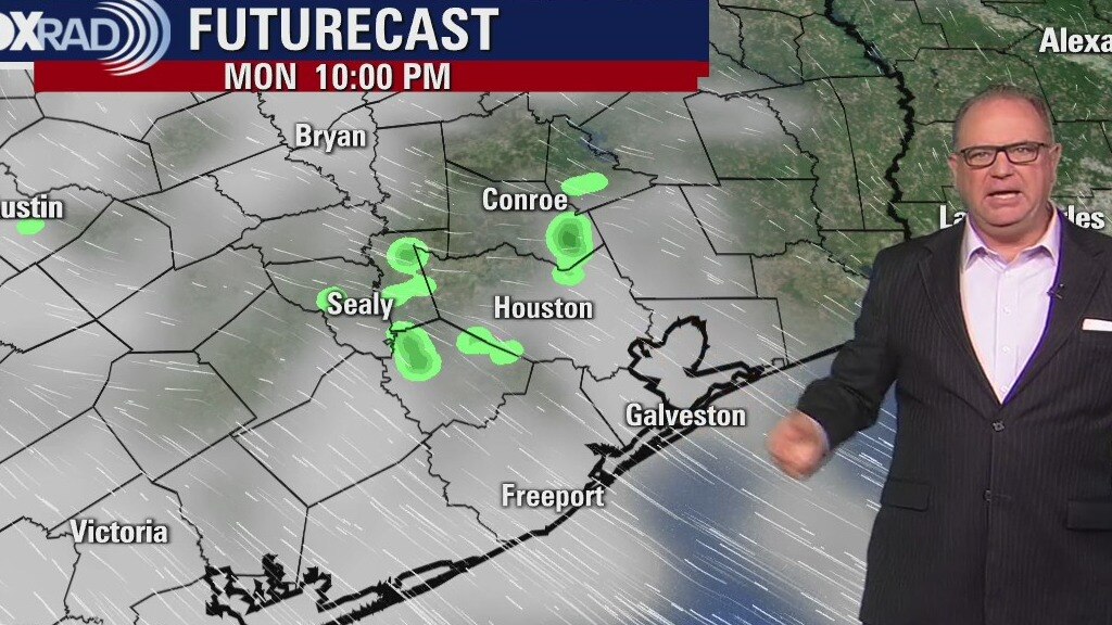
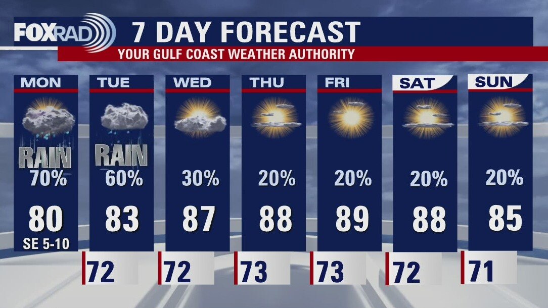
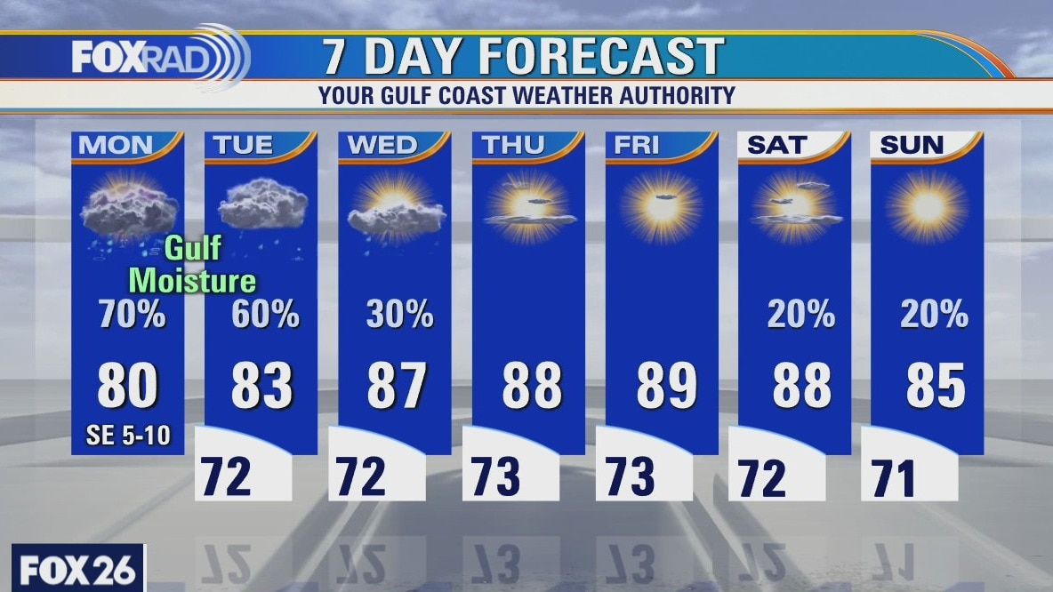
Another soggy day on Monday as more Gulf moisture streams across the Houston area. A flash flood watch has been expanded to include most of the Houston area. A break in rain tonight but more rain on Tuesday. Finally we will start to dry out towards the end of the week. As the rain chances decrease, the temperatures increase, back to seasonal temperatures near 90.
Another soggy day on Monday as more Gulf moisture streams across the Houston area. A flash flood watch has been expanded to include most of the Houston area. A break in rain tonight but more rain on Tuesday. Finally we will start to dry out towards the end of the week. As the rain chances decrease, the temperatures increase, back to seasonal temperatures near 90.
Monday weather forecast
Another soggy day on Monday as more Gulf moisture streams across the Houston area. A Flash Flood Watch for our Southwest counties until 10pm this evening. A break in rain tonight but more rain on Tuesday. Finally we will start to dry out towards the end of the week. As the rain chances decrease the temperatures increase, back to seasonal temperatures near 90.
Another soggy day on Monday as more Gulf moisture streams across the Houston area. A Flash Flood Watch for our Southwest counties until 10pm this evening. A break in rain tonight but more rain on Tuesday. Finally we will start to dry out towards the end of the week. As the rain chances decrease the temperatures increase, back to seasonal temperatures near 90.
Houston-area weather forecast: May 23rd
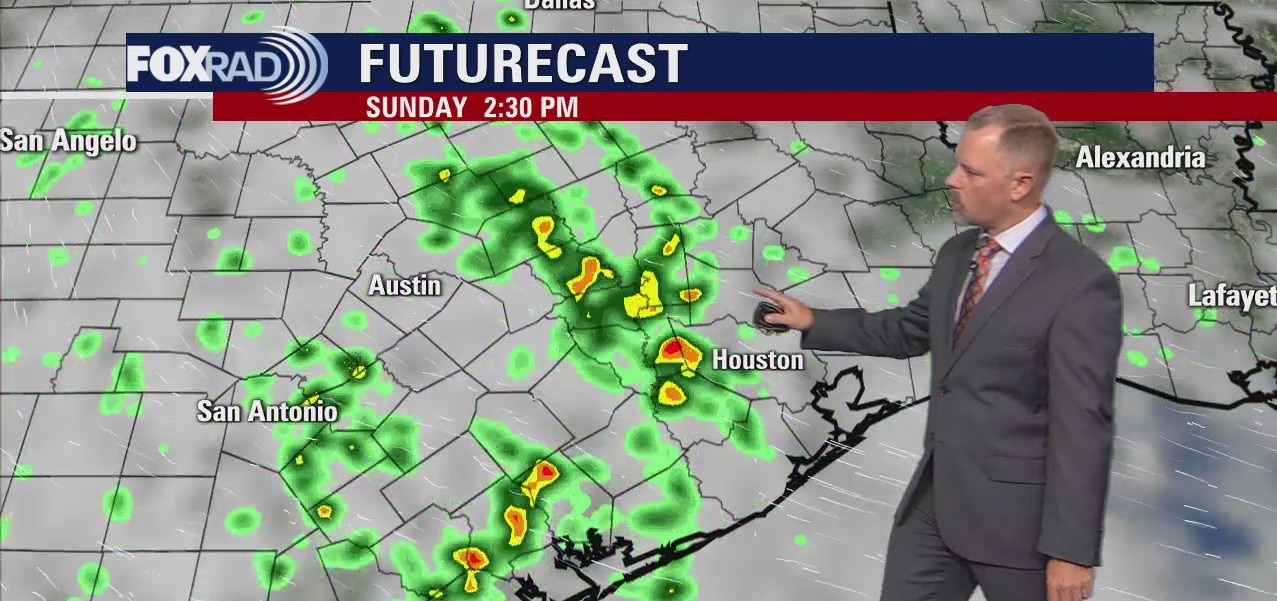
We're hanging onto those rain chances today and tomorrow, even lasting into Tuesday, however drier times are expected by midweek. Temperatures will remain on the cooler side, when compared to our 30 year climatological average, with highs reaching the low 80s. Regarding Sunday, a Flash Flood Watch remains in effect for our far southwestern counties until Monday morning. That watch is in effect because the rain chances remain highest south and west of Houston and the soil is already saturated.
We're hanging onto those rain chances today and tomorrow, even lasting into Tuesday, however drier times are expected by midweek. Temperatures will remain on the cooler side, when compared to our 30 year climatological average, with highs reaching the low 80s. Regarding Sunday, a Flash Flood Watch remains in effect for our far southwestern counties until Monday morning. That watch is in effect because the rain chances remain highest south and west of Houston and the soil is already saturated.
Saturday evening weather forecast with Meteorologist John Dawson
We are looking at some rain moving in. It's been sort of light showers for most of the day Saturday, but now beginning to go a little bit more organized as some of the storms are still kind of rolling in off of the gulf. FOX 26 Meteorologist John Dawson has more with your FOX 26 Weather.
We are looking at some rain moving in. It's been sort of light showers for most of the day Saturday, but now beginning to go a little bit more organized as some of the storms are still kind of rolling in off of the gulf. FOX 26 Meteorologist John Dawson has more with your FOX 26 Weather.

Houston-area weather forecast: May 22nd
The Gulf disturbance that we all watched closely yesterday continues to push inland this morning bringing scattered showers across the area. A coastal flood threat lingers into Sunday morning with gusty winds expected to calm later this afternoon. Showers and pockets of heavy rain are likely, once again, today. We'll see rain chances eventually drop as we work our way through next week. Sunday will also be a mostly dry day, but a few showers can't be ruled out. Highs will reach the low and mid 80s today and slowly warm as we head toward the end of next week.
The Gulf disturbance that we all watched closely yesterday continues to push inland this morning bringing scattered showers across the area. A coastal flood threat lingers into Sunday morning with gusty winds expected to calm later this afternoon. Showers and pockets of heavy rain are likely, once again, today. We'll see rain chances eventually drop as we work our way through next week. Sunday will also be a mostly dry day, but a few showers can't be ruled out. Highs will reach the low and mid 80s today and slowly warm as we head toward the end of next week.
Saturday morning weather forecast
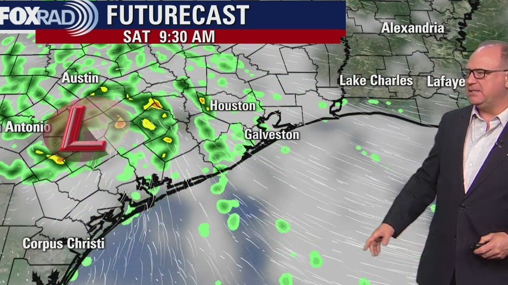
Rain will still be likely on Saturday after that tropical low in the Gulf makes landfall near Corpus Christi. Scattered downpours are possible over the weekend, but most areas will get less than an inch of rainfall. Sunday looks somewhat drier and so does the coming week with a few showers and highs back into the mid to upper 80s.
Rain will still be likely on Saturday after that tropical low in the Gulf makes landfall near Corpus Christi. Scattered downpours are possible over the weekend, but most areas will get less than an inch of rainfall. Sunday looks somewhat drier and so does the coming week with a few showers and highs back into the mid to upper 80s.
Friday evening weather forecast
Rain will still be likely on Saturday after that tropical low in the Gulf makes landfall near Corpus Christi. Scattered downpours are possible over the weekend, but most areas will get less than an inch of rainfall. Sunday looks somewhat drier and so does the coming week with a few showers and highs back into the mid to upper 80s.
Rain will still be likely on Saturday after that tropical low in the Gulf makes landfall near Corpus Christi. Scattered downpours are possible over the weekend, but most areas will get less than an inch of rainfall. Sunday looks somewhat drier and so does the coming week with a few showers and highs back into the mid to upper 80s.
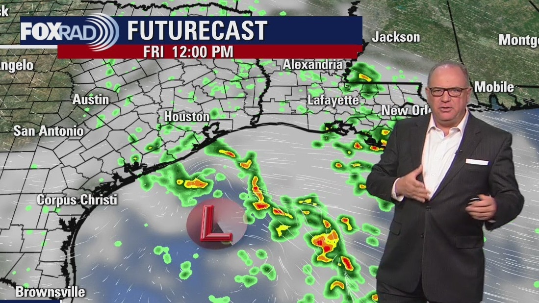
Friday weather forecast
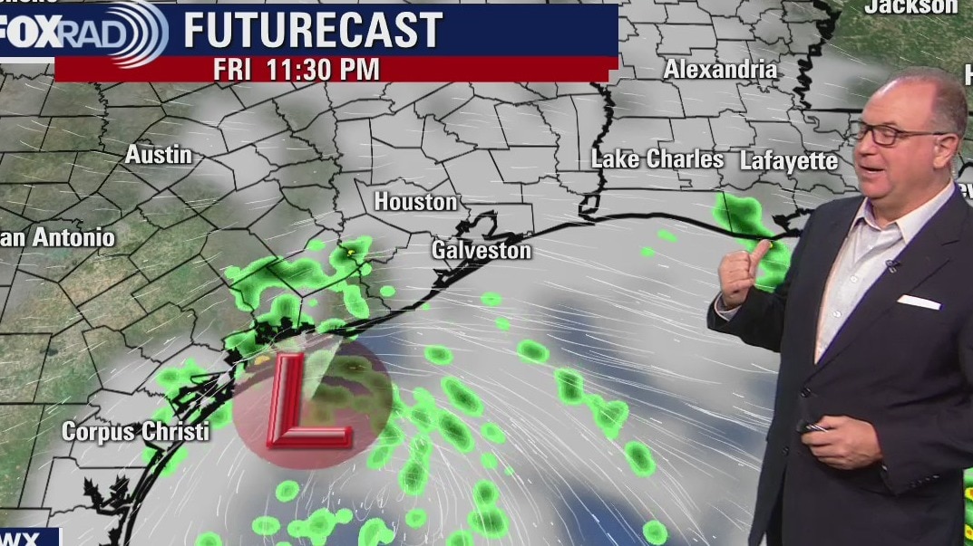
Rain chances running on the high side for the next couple of days as we watch an area of low pressure in the western Gulf move toward the Texas coastline. At the moment, the Hurricane Center is giving this area a 40% chance of developing into a tropical system. Chances are low as sea surface temps remain cooler, in the mid 70s, and the environment is not all that supportive for organization. Our best opportunity at seeing rain will be this evening and overnight, lingering into Saturday. Sunday could also start off with scattered rain, but by the afternoon we should dry out. Highs each day will reach the upper 70s and low 80s.
Rain chances running on the high side for the next couple of days as we watch an area of low pressure in the western Gulf move toward the Texas coastline. At the moment, the Hurricane Center is giving this area a 40% chance of developing into a tropical system. Chances are low as sea surface temps remain cooler, in the mid 70s, and the environment is not all that supportive for organization. Our best opportunity at seeing rain will be this evening and overnight, lingering into Saturday. Sunday could also start off with scattered rain, but by the afternoon we should dry out. Highs each day will reach the upper 70s and low 80s.
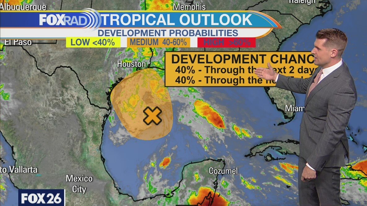
Friday morning weather forecast/tropics update
The risk for flooding has dropped, but showers are likely through Saturday. An area of high pressure to our east will push more humidity into SE Texas and that means scattered showers and a few storms. It will be a bit drier starting Sunday and into the coming week.
The risk for flooding has dropped, but showers are likely through Saturday. An area of high pressure to our east will push more humidity into SE Texas and that means scattered showers and a few storms. It will be a bit drier starting Sunday and into the coming week.