

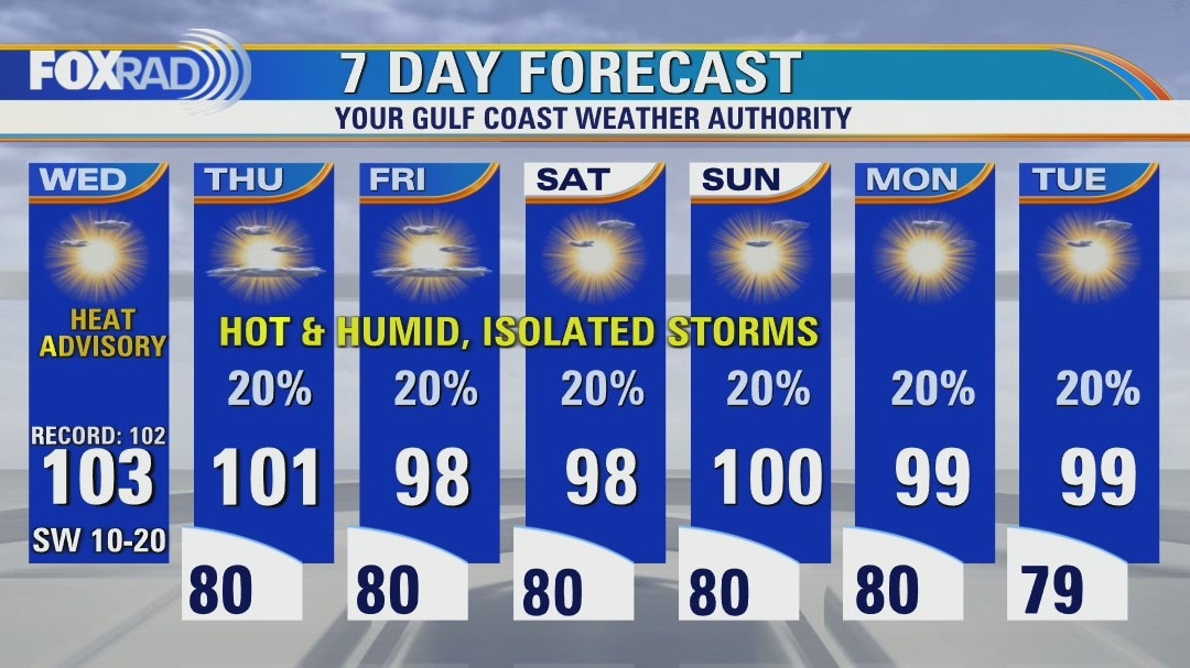
Mostly sunny, very hot Wednesday with highs in the low 100s
Houston has reached highs of 100 or higher 11 times this month and 16 times this year - we will likely add to those totals today. Look for a familiar weather day with sunshine, hot breezes and highs in the low 100s. There is a very small chance for rain today, but isolated late-day storms are more likely beginning Thursday through the weekend. Elevated fire risk continues for areas north and west of Houston, but burn bans are in effect for our entire area until further notice.
Houston has reached highs of 100 or higher 11 times this month and 16 times this year - we will likely add to those totals today. Look for a familiar weather day with sunshine, hot breezes and highs in the low 100s. There is a very small chance for rain today, but isolated late-day storms are more likely beginning Thursday through the weekend. Elevated fire risk continues for areas north and west of Houston, but burn bans are in effect for our entire area until further notice.
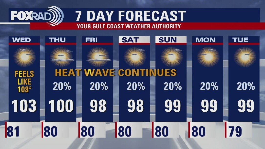
Wednesday morning weather forecast
Extreme heat continues across Southeast Texas and should be around for several more days. The Northwest Counties in the FOX26 area will be under an Excessive Heat Warning for Wednesday and the rest of the area under a Heat Advisory. Use caution with any strenuous activities outdoors. There will be low chances for isolated rain as we move towards the end of the week.
Extreme heat continues across Southeast Texas and should be around for several more days. The Northwest Counties in the FOX26 area will be under an Excessive Heat Warning for Wednesday and the rest of the area under a Heat Advisory. Use caution with any strenuous activities outdoors. There will be low chances for isolated rain as we move towards the end of the week.
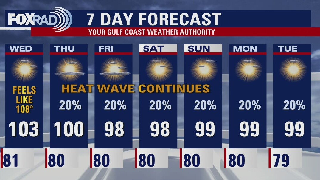
Tuesday evening weather forecast
Extreme heat continues across Southeast Texas and should be around for several more days. The Northwest Counties in the FOX26 area will be under an Excessive Heat Warning for Wednesday and the rest of the area under a Heat Advisory. Use caution with any strenuous activities outdoors. There will be low chances for isolated rain as we move toward the end of the week.
Extreme heat continues across Southeast Texas and should be around for several more days. The Northwest Counties in the FOX26 area will be under an Excessive Heat Warning for Wednesday and the rest of the area under a Heat Advisory. Use caution with any strenuous activities outdoors. There will be low chances for isolated rain as we move toward the end of the week.

Hot, sultry Tuesday with highs near the 100s
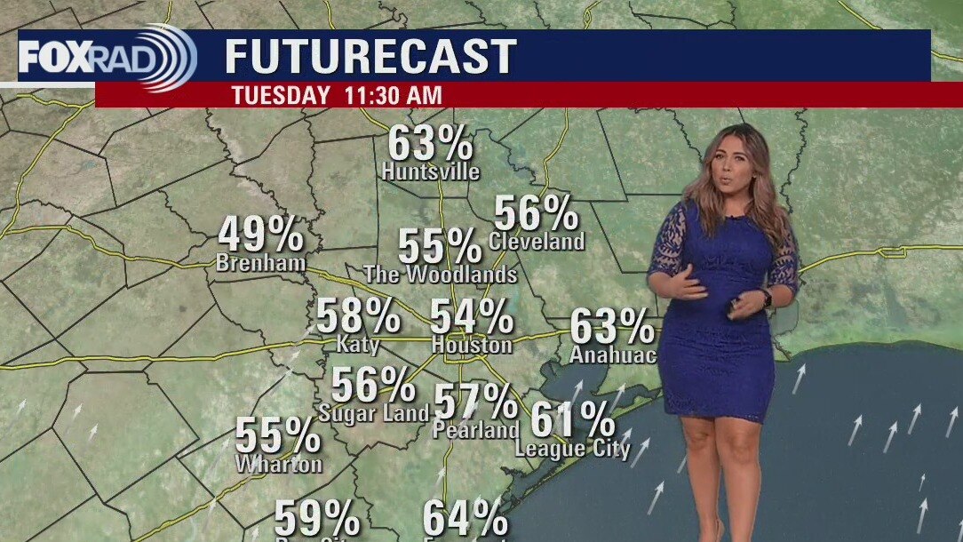
Extreme heat continues across Texas again today and through the extended forecast along with a worsening drought and increasing threats for wildfires. All-time record heat has affected Europe including the warmest night on record in England - and they've been recording temperature records since the 1600s! Otherwise, locally, the forecast stays familiar with highs near 100 and heat advisories through at least Wednesday. A few showers are possible by the end of the week.
Extreme heat continues across Texas again today and through the extended forecast along with a worsening drought and increasing threats for wildfires. All-time record heat has affected Europe including the warmest night on record in England - and they've been recording temperature records since the 1600s! Otherwise, locally, the forecast stays familiar with highs near 100 and heat advisories through at least Wednesday. A few showers are possible by the end of the week.
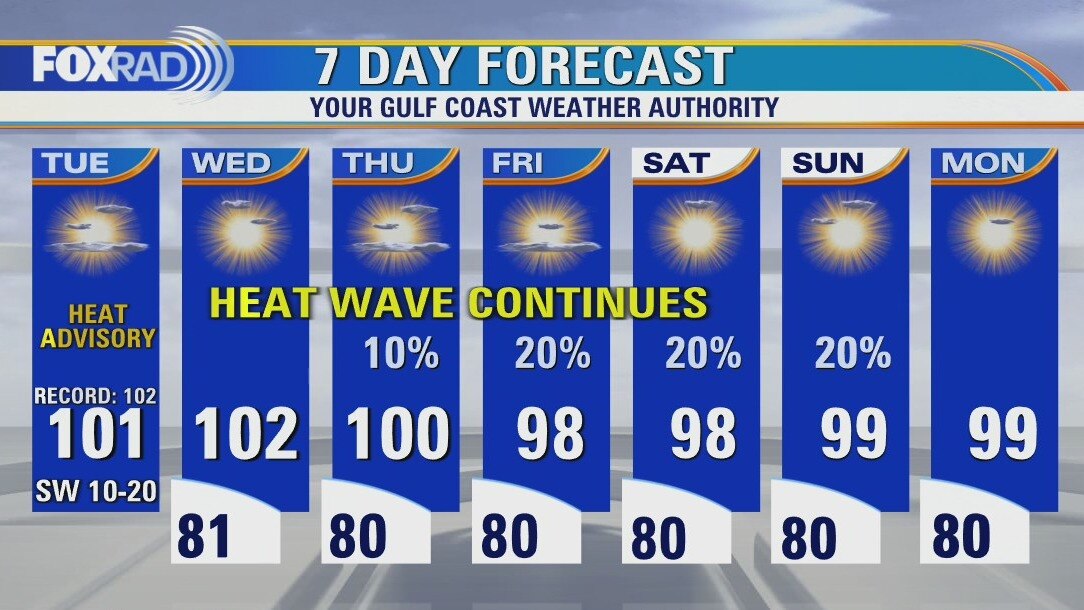
Sunny, hot and humid Tuesday with highs near 100
Extreme heat continues across Texas again today and through the extended forecast along with a worsening drought and increasing threats for wildfires. All-time record heat has affected Europe including the warmest night on record in England - and they've been recording temperature records since the 1600s! Otherwise, locally, the forecast stays familiar with highs near 100 and heat advisories through at least Wednesday. A few showers are possible by the end of the week.
Extreme heat continues across Texas again today and through the extended forecast along with a worsening drought and increasing threats for wildfires. All-time record heat has affected Europe including the warmest night on record in England - and they've been recording temperature records since the 1600s! Otherwise, locally, the forecast stays familiar with highs near 100 and heat advisories through at least Wednesday. A few showers are possible by the end of the week.
Tuesday morning weather forecast
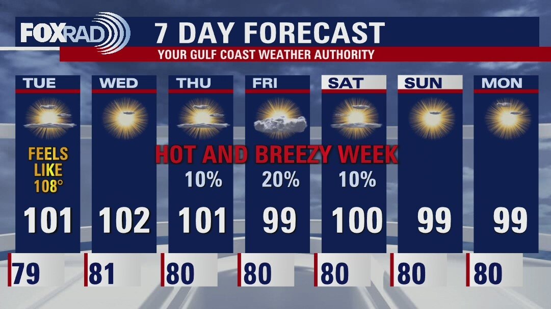
Not much changes on the day to day as we prepare for another prolonged hot stretch. Heat Advisories will be likely for most of the week, with Excessive Heat Warnings possible father inland. Wednesday will likely be the hottest day of the week, and though rain chances remain slim our best bet at seeing anything is late week as a trough advances west through the Gulf. At the very least, it looks to increase our cloud cover and dull temperatures slightly. Aside from that, plan for daytime highs within a few degrees of 100 and "lows" firmly parked near 80. Breezy conditions all week long will help some, but heat safety will need to be practiced daily.
Not much changes on the day to day as we prepare for another prolonged hot stretch. Heat Advisories will be likely for most of the week, with Excessive Heat Warnings possible father inland. Wednesday will likely be the hottest day of the week, and though rain chances remain slim our best bet at seeing anything is late week as a trough advances west through the Gulf. At the very least, it looks to increase our cloud cover and dull temperatures slightly. Aside from that, plan for daytime highs within a few degrees of 100 and "lows" firmly parked near 80. Breezy conditions all week long will help some, but heat safety will need to be practiced daily.
Monday evening weather forecast
Not much changes on the day to day as we prepare for another prolonged hot stretch. Heat Advisories will be likely for most of the week, with Excessive Heat Warnings possible father inland. Wednesday will likely be the hottest day of the week, and though rain chances remain slim our best bet at seeing anything is late week as a trough advances west through the Gulf. At the very least, it looks to increase our cloud cover and dull temperatures slightly. Aside from that, plan for daytime highs within a few degrees of 100 and "lows" firmly parked near 80. Breezy conditions all week long will help some, but heat safety will need to be practiced daily.
Not much changes on the day to day as we prepare for another prolonged hot stretch. Heat Advisories will be likely for most of the week, with Excessive Heat Warnings possible father inland. Wednesday will likely be the hottest day of the week, and though rain chances remain slim our best bet at seeing anything is late week as a trough advances west through the Gulf. At the very least, it looks to increase our cloud cover and dull temperatures slightly. Aside from that, plan for daytime highs within a few degrees of 100 and "lows" firmly parked near 80. Breezy conditions all week long will help some, but heat safety will need to be practiced daily.
Heatwave this week with slim rain chances
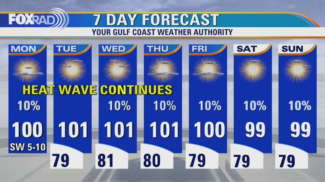
We are back in heat wave mode across Texas with record or near record heat each day this week. In addition, rain chances are very slim, so the drought will certainly worsen. Look for highs in the Houston area to range from 98 to 103 each day with coastal highs in the mid 90s. Next week also looks warmer than our normal high of 95.
We are back in heat wave mode across Texas with record or near record heat each day this week. In addition, rain chances are very slim, so the drought will certainly worsen. Look for highs in the Houston area to range from 98 to 103 each day with coastal highs in the mid 90s. Next week also looks warmer than our normal high of 95.
Sunny, hot and hazy Monday with highs in the upper 90s
We are back in heat wave mode across Texas with record or near-record heat each day this week. In addition, rain chances are very slim, so the drought will certainly worsen. Look for highs in the Houston area to range from 98 to 103 each day with coastal highs in the mid 90s. Next week also looks warmer than our normal high of 95.
We are back in heat wave mode across Texas with record or near-record heat each day this week. In addition, rain chances are very slim, so the drought will certainly worsen. Look for highs in the Houston area to range from 98 to 103 each day with coastal highs in the mid 90s. Next week also looks warmer than our normal high of 95.
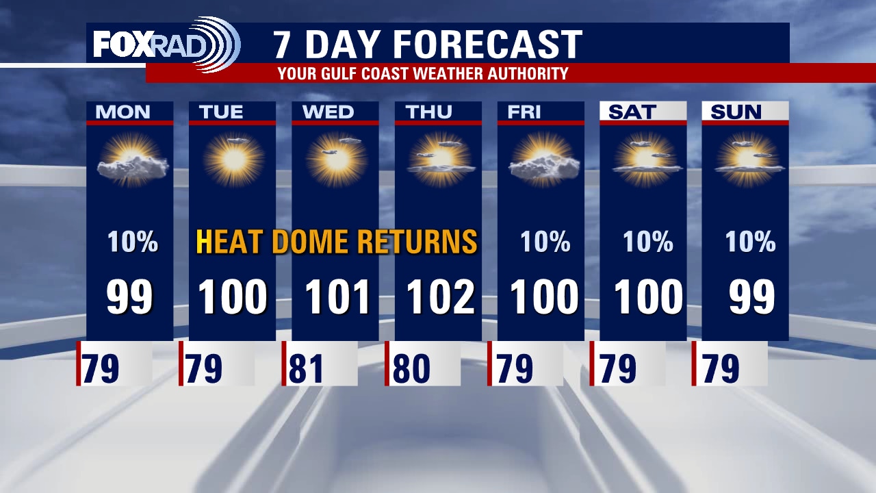
Sunday night leading into Monday morning weather forecast
If you noticed milky, hazy skies over the weekend it was thanks to a plume of Saharan dust that has been keeping the Tropical Atlantic very quiet. That should mix out as high pressure continues to build and dominate not only our weather pattern, but the majority of the country is also bracing for above average temps. Be on the lookout for several more 100+ degree days, with heat advisories likely throughout the week. Sunshine will be the dominant weather factor, but we'll also be fairly breezy this week which is good news for wind power and the grid. As for rain? Only the lucky ones will squeak out a very isolated shower or storm this week. However, rain chances might get a boost closer to the weekend as a trough advances west through the Gulf. Fingers crossed!
If you noticed milky, hazy skies over the weekend it was thanks to a plume of Saharan dust that has been keeping the Tropical Atlantic very quiet. That should mix out as high pressure continues to build and dominate not only our weather pattern, but the majority of the country is also bracing for above average temps. Be on the lookout for several more 100+ degree days, with heat advisories likely throughout the week. Sunshine will be the dominant weather factor, but we'll also be fairly breezy this week which is good news for wind power and the grid. As for rain? Only the lucky ones will squeak out a very isolated shower or storm this week. However, rain chances might get a boost closer to the weekend as a trough advances west through the Gulf. Fingers crossed!

Sunday afternoon weather forecast with Chief Meteorologist Mike Iscovitz
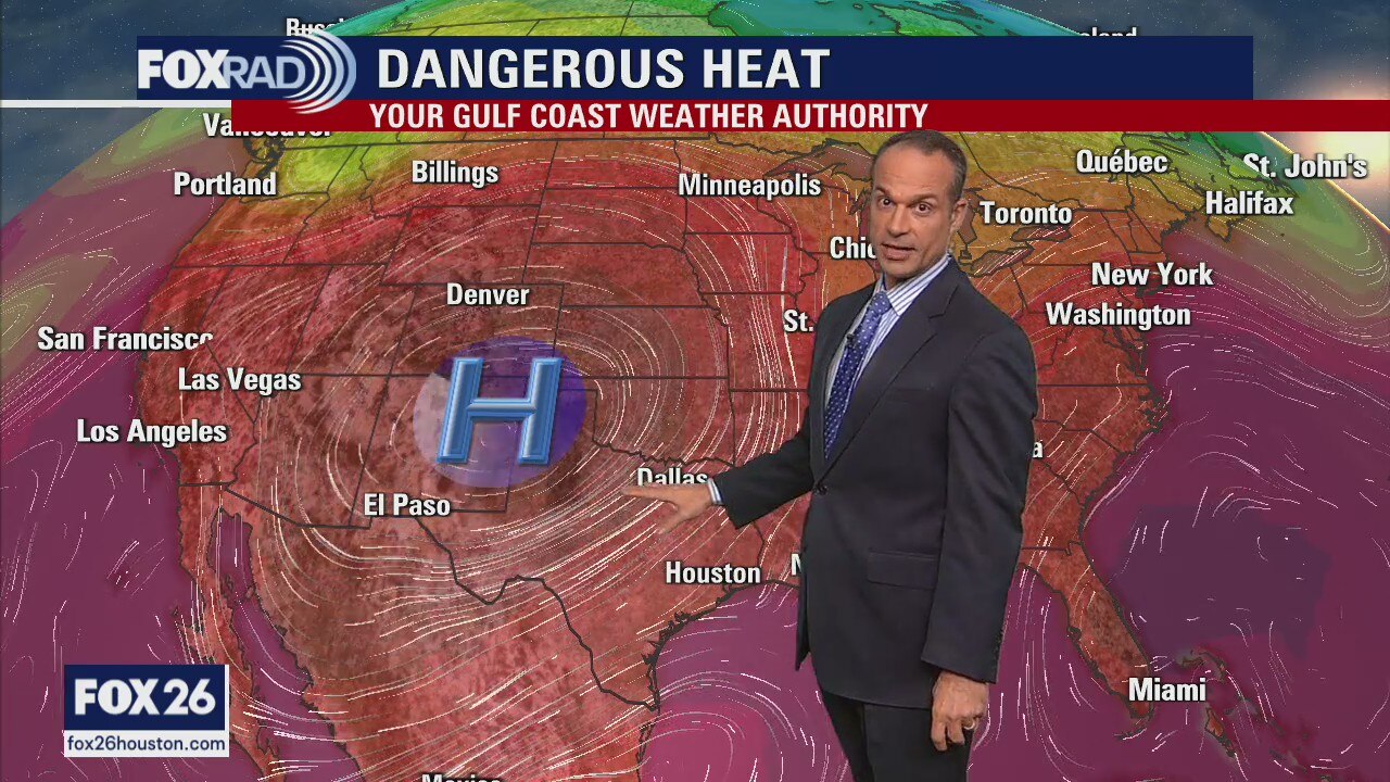
Dangerous heat will continue across much of the US this week with a heat dome building back into the Southwest and its effect on Texas will be strong sunshine, high heat, and very little chance for rain.
Dangerous heat will continue across much of the US this week with a heat dome building back into the Southwest and its effect on Texas will be strong sunshine, high heat, and very little chance for rain.
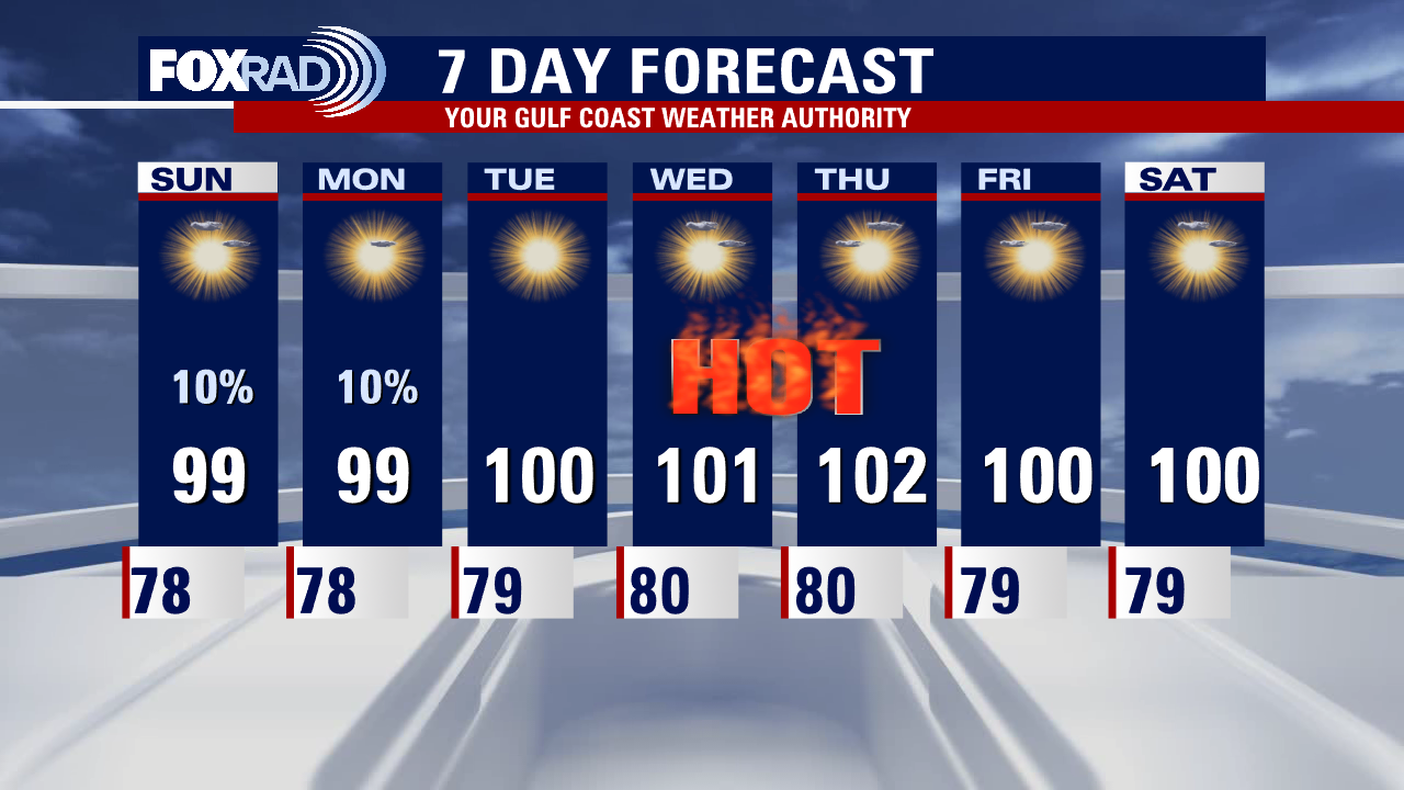
Saturday night leading into Sunday morning weather forecast
The dog days of summer continue to bring more heat and humidity. Another ridge of high pressure is building, allowing for plenty of sunshine for the next several days. Triple-digit temperatures look to return by Tuesday. Make sure you are taking heat safety precautions and checking on elderly neighbors and pets!
The dog days of summer continue to bring more heat and humidity. Another ridge of high pressure is building, allowing for plenty of sunshine for the next several days. Triple-digit temperatures look to return by Tuesday. Make sure you are taking heat safety precautions and checking on elderly neighbors and pets!
Saturday Morning Forecast with Meteorologist Lena Maria
The moisture express has left the station, but not before bringing drought stricken areas between 1-3" of rainfall over the past 2 days. It also finally put an end to our 7 day streak of 100+ temps at IAH. Enjoy the 90s, as they are short lived. Another heat dome is building, and looks to return us to triple digits accompanied by mostly dry weather by the middle of next week. That area of high pressure could bring historic heat to parts of Oklahoma, that may see temperatures as high as 110-115. Parts of Europe are also bracing for potentially historic heat.
The moisture express has left the station, but not before bringing drought stricken areas between 1-3" of rainfall over the past 2 days. It also finally put an end to our 7 day streak of 100+ temps at IAH. Enjoy the 90s, as they are short lived. Another heat dome is building, and looks to return us to triple digits accompanied by mostly dry weather by the middle of next week. That area of high pressure could bring historic heat to parts of Oklahoma, that may see temperatures as high as 110-115. Parts of Europe are also bracing for potentially historic heat.
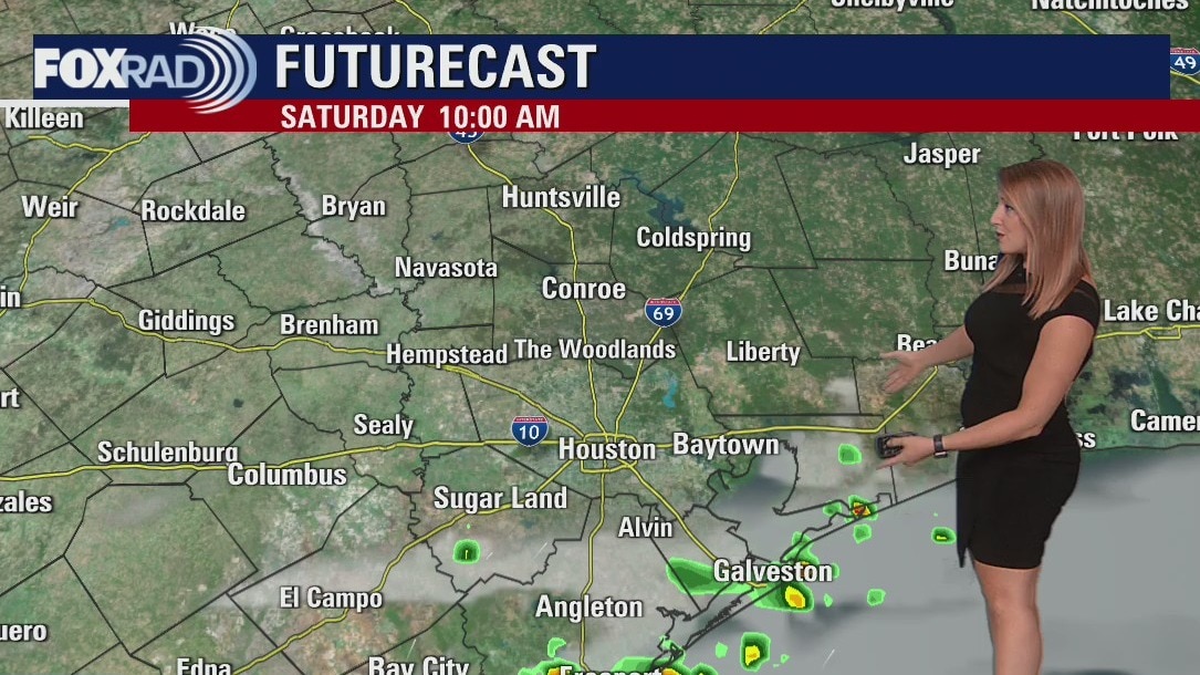
Saturday morning weather forecast
Another ridge of high pressure begins to build this weekend, allowing for more sunshine and drier conditions to settle in. An isolated shower or thunderstorm will still be possible but the activity looks to be very hit or miss in variety. Temperatures will again be on the rise, with highs in the triple digits by the middle of next week.
Another ridge of high pressure begins to build this weekend, allowing for more sunshine and drier conditions to settle in. An isolated shower or thunderstorm will still be possible but the activity looks to be very hit or miss in variety. Temperatures will again be on the rise, with highs in the triple digits by the middle of next week.

Friday evening weather forecast with Meteorologist Adrienne Vonn
Another ridge of high pressure begins to build this weekend, allowing for more sunshine and drier conditions to settle in. An isolated shower or thunderstorm will still be possible but the activity looks to be very hit or miss in variety. Temperatures will again be on the rise, with highs in the triple digits by the middle of next week.
Another ridge of high pressure begins to build this weekend, allowing for more sunshine and drier conditions to settle in. An isolated shower or thunderstorm will still be possible but the activity looks to be very hit or miss in variety. Temperatures will again be on the rise, with highs in the triple digits by the middle of next week.

Friday afternoon weather forecast with Meteorologist Lena Maria Arango
A disturbance in the gulf is driving in a deep plume of moisture keeping heavy rain a possibility mainly along the coastline today. Activity inland will be more scattered as the day goes on but look for pockets of downpours and a few rumbles of thunder. Hopefully, you get lucky today, because it's our best opportunity for rainfall before chances drop significantly. Heat and humidity will be back on the rise as another ridge of high-pressure build and we'll be back to monitoring for heat advisories and hundo's once again by the middle of next week.
A disturbance in the gulf is driving in a deep plume of moisture keeping heavy rain a possibility mainly along the coastline today. Activity inland will be more scattered as the day goes on but look for pockets of downpours and a few rumbles of thunder. Hopefully, you get lucky today, because it's our best opportunity for rainfall before chances drop significantly. Heat and humidity will be back on the rise as another ridge of high-pressure build and we'll be back to monitoring for heat advisories and hundo's once again by the middle of next week.
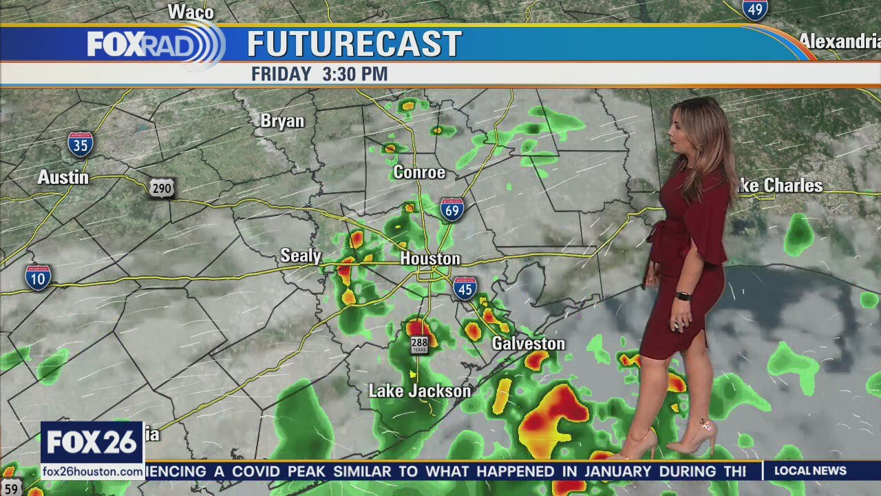
More rainfall expected today
One more decent chance at beneficial rainfall exists today, primarily along the coastline. Showers, and isolated downpours, and thunderstorms look to propagate inland some throughout the afternoon. Increased cloud cover should keep most daytime highs in the low-mid 90s. The weekend looks warmer, more humid and with lower rain chances though keep your eyes on the FOX 26 Weather app for an occasional passing shower or storm. Rain chances continue to drop as we head into next week, and not what you wanted to hear, I know, but we crank up the heat to near 100 again as another ridge of high pressure builds.
One more decent chance at beneficial rainfall exists today, primarily along the coastline. Showers, and isolated downpours, and thunderstorms look to propagate inland some throughout the afternoon. Increased cloud cover should keep most daytime highs in the low-mid 90s. The weekend looks warmer, more humid and with lower rain chances though keep your eyes on the FOX 26 Weather app for an occasional passing shower or storm. Rain chances continue to drop as we head into next week, and not what you wanted to hear, I know, but we crank up the heat to near 100 again as another ridge of high pressure builds.
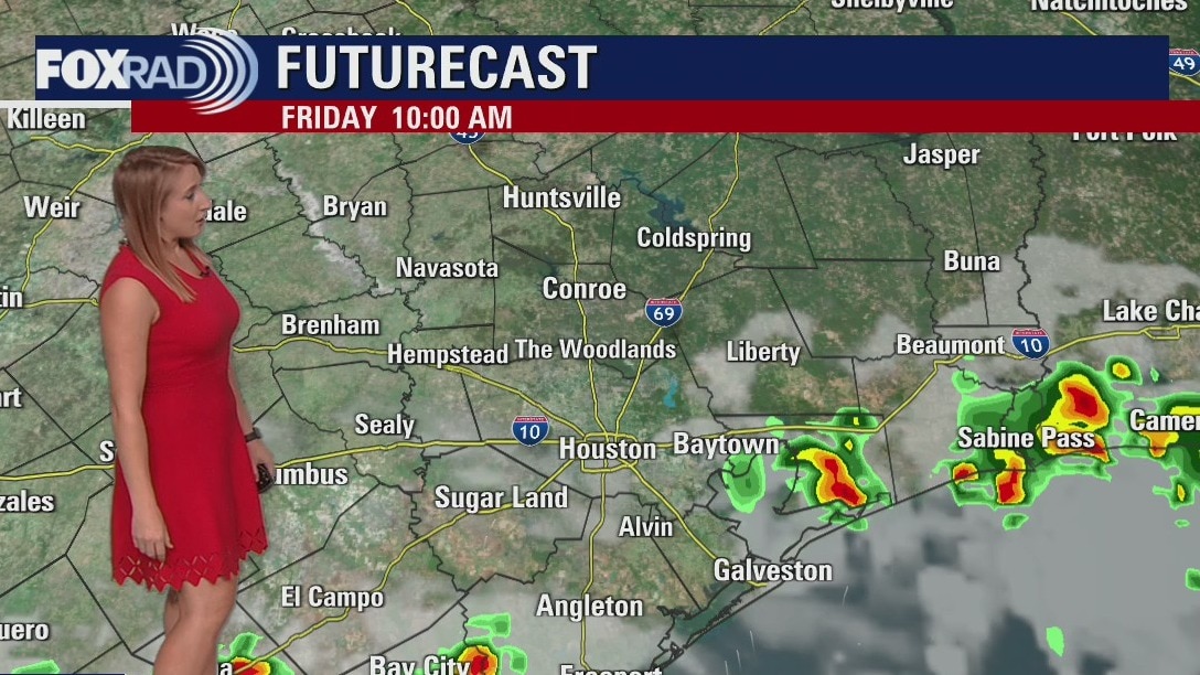
Friday morning weather forecast
Scattered rain and thunderstorm chances continue tomorrow, with the highest coverage in the morning and early afternoon. We'll trend drier as we head into the weekend with more sunshine and more heat. Highs will again soar to the century mark by the middle of next week.
Scattered rain and thunderstorm chances continue tomorrow, with the highest coverage in the morning and early afternoon. We'll trend drier as we head into the weekend with more sunshine and more heat. Highs will again soar to the century mark by the middle of next week.

Thursday evening weather forecast with Meteorologist Adrienne Vonn
Scattered rain and thunderstorm chances continue tomorrow, with the highest coverage in the morning and early afternoon. We'll trend drier as we head into the weekend with more sunshine and more heat. Highs will again soar to the century mark by the middle of next week.
Scattered rain and thunderstorm chances continue tomorrow, with the highest coverage in the morning and early afternoon. We'll trend drier as we head into the weekend with more sunshine and more heat. Highs will again soar to the century mark by the middle of next week.

Thursday afternoon weather forecast with Meteorologist Lena Maria Arango
Our highest rain chances are between today and tomorrow, with scattered showers, storms, and even a few downpours possible. A stronger storm or two may mix down some gusty winds, but severe weather is not expected. Tomorrow morning, some heavier rain is possible along the coast with showers and storms pushing inland throughout the day. Past that, our rain chances drop back to the daily lotto category and the heat and humidity continue. Enjoy the slightly subdued temperatures, for now, looks like we'll be adding more 100s to the triple-digit tally fairly soon. Saharan dust looks to keep the Atlantic quiet through the next 2-5 days.
Our highest rain chances are between today and tomorrow, with scattered showers, storms, and even a few downpours possible. A stronger storm or two may mix down some gusty winds, but severe weather is not expected. Tomorrow morning, some heavier rain is possible along the coast with showers and storms pushing inland throughout the day. Past that, our rain chances drop back to the daily lotto category and the heat and humidity continue. Enjoy the slightly subdued temperatures, for now, looks like we'll be adding more 100s to the triple-digit tally fairly soon. Saharan dust looks to keep the Atlantic quiet through the next 2-5 days.