

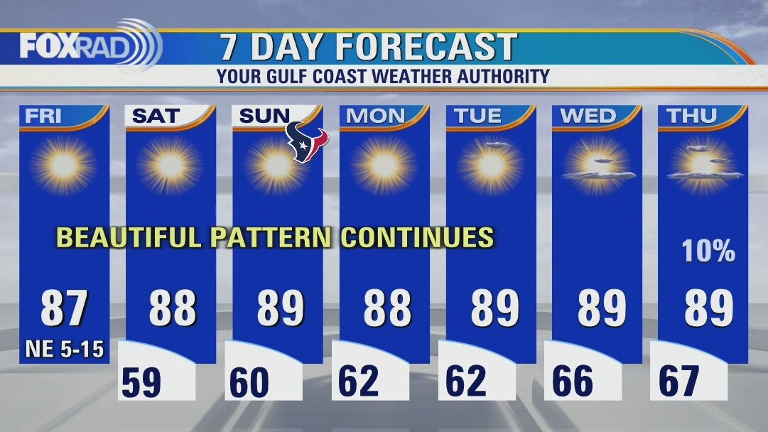
Clear and pleasant Friday morning, then sunny and dry
Hurricane Ian will impact the Carolinas today with gusty winds, storm surge and heavy rain, but our weather couldn't be nicer. One caution is that waves from Hurricane Ian could increase the risk for rip currents at our beaches for today and Saturday. Otherwise, overnight lows will reach the 50s and low 60s (the coolest since April) and afternoons will bring warm sunshine and very low humidity. This pattern will stay in place through at least the middle of next week.
Hurricane Ian will impact the Carolinas today with gusty winds, storm surge and heavy rain, but our weather couldn't be nicer. One caution is that waves from Hurricane Ian could increase the risk for rip currents at our beaches for today and Saturday. Otherwise, overnight lows will reach the 50s and low 60s (the coolest since April) and afternoons will bring warm sunshine and very low humidity. This pattern will stay in place through at least the middle of next week.
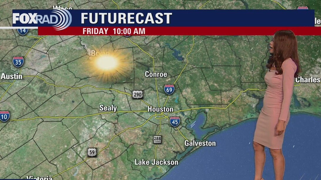
Friday morning weather forecast
Stellar weather continues for SE Texas if you like sunshine and low humidity! It will be more of the same through the end of the week with temperatures in the upper 80s during the afternoon and cooler nights in the 50s. Ian is once again a hurricane set to make another landfall along the South Carolina coast early Friday afternoon. The Carolinas will be threatened with major flooding, storm surge, and hurricane-force winds Friday.
Stellar weather continues for SE Texas if you like sunshine and low humidity! It will be more of the same through the end of the week with temperatures in the upper 80s during the afternoon and cooler nights in the 50s. Ian is once again a hurricane set to make another landfall along the South Carolina coast early Friday afternoon. The Carolinas will be threatened with major flooding, storm surge, and hurricane-force winds Friday.

Thursday evening weather with Meteorologist Remeisha Shade
Stellar weather continues for SE Texas if you like sunshine and low humidity! It will be more of the same through the end of the week with temperatures in the upper 80s during the afternoon and cooler nights in the 50s. Ian is once again a hurricane set to make another landfall along the South Carolina coast early Friday afternoon. The Carolinas will be threatened with major flooding, storm surge, and hurricane-force winds Friday.
Stellar weather continues for SE Texas if you like sunshine and low humidity! It will be more of the same through the end of the week with temperatures in the upper 80s during the afternoon and cooler nights in the 50s. Ian is once again a hurricane set to make another landfall along the South Carolina coast early Friday afternoon. The Carolinas will be threatened with major flooding, storm surge, and hurricane-force winds Friday.
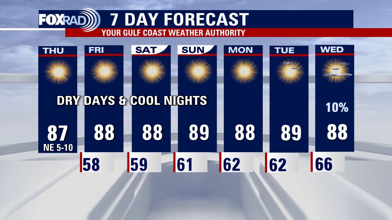
Thursday afternoon weather forecast with Meteorologist Lena Maria
Our local weather remains very quiet and pleasant, though you may notice an increase in allergens and the dry conditions have created a bit of an elevated fire risk. Our drought has also slightly worsened, and as you can see - really, no rain in sight. As now TS Ian moves away from the Florida coastline, rescue efforts can begin though the road to recovery will be long. Ian looks to strengthen to a Category 1 Hurricane again, before making a 3rd landfall along the Carolina Coastline where a Hurricane Warning is already in effect.
Our local weather remains very quiet and pleasant, though you may notice an increase in allergens and the dry conditions have created a bit of an elevated fire risk. Our drought has also slightly worsened, and as you can see - really, no rain in sight. As now TS Ian moves away from the Florida coastline, rescue efforts can begin though the road to recovery will be long. Ian looks to strengthen to a Category 1 Hurricane again, before making a 3rd landfall along the Carolina Coastline where a Hurricane Warning is already in effect.
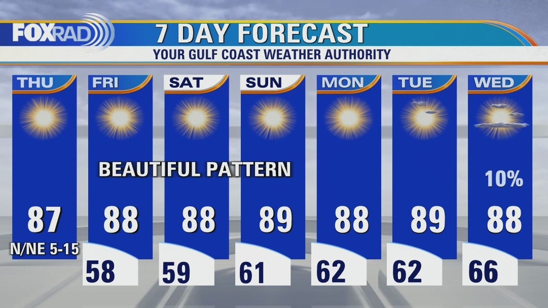
Clear and pleasant Thursday morning, then sunny and very dry
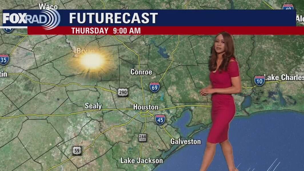
We will continue to enjoy an outstanding fall weather pattern through the weekend and beyond. Look for some semi-chilly overnights with lows in the 50s and sunny days with very low humidity. As Florida begins the recovery from Hurricane Ian, the storm will make its way toward South Carolina as either a strong tropical storm or a possible hurricane.
We will continue to enjoy an outstanding fall weather pattern through the weekend and beyond. Look for some semi-chilly overnights with lows in the 50s and sunny days with very low humidity. As Florida begins the recovery from Hurricane Ian, the storm will make its way toward South Carolina as either a strong tropical storm or a possible hurricane.
Thursday morning weather forecast
We get to enjoy more stellar weather across SE Texas! Ridge of high pressure remains dominant across the region and that means very dry air in place and quiet weather. Look for pleasant nights in the 50s and 60s with near average temperatures in the upper 80s to near 90 during the afternoon. We are still tracking Hurricane Ian which made landfall as a Category 4 150 mph tropical cyclone this afternoon near Cayo Costa, Florida. Ian will weaken as it crosses the Florida peninsula tonight and Friday. But it will still pose a huge flood risk and produce some damaging wind.
We get to enjoy more stellar weather across SE Texas! Ridge of high pressure remains dominant across the region and that means very dry air in place and quiet weather. Look for pleasant nights in the 50s and 60s with near average temperatures in the upper 80s to near 90 during the afternoon. We are still tracking Hurricane Ian which made landfall as a Category 4 150 mph tropical cyclone this afternoon near Cayo Costa, Florida. Ian will weaken as it crosses the Florida peninsula tonight and Friday. But it will still pose a huge flood risk and produce some damaging wind.
Wednesday evening weather forecast with Meteorologist Remeisha Shade
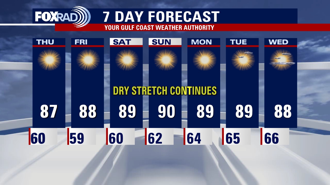
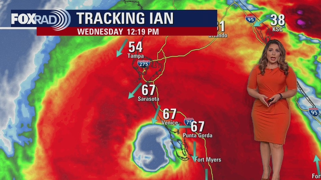
We get to enjoy more stellar weather across SE Texas! A ridge of high pressure remains dominant across the region and that means very dry air in place and quiet weather. Look for pleasant nights in the 50s and 60s with near average temperatures in the upper 80s to near 90 during the afternoon. We are still tracking Hurricane Ian which made landfall as a Category 4 150 mph tropical cyclone this afternoon near Cayo Costa, Florida. Ian will weaken as it crosses the Florida peninsula tonight and Friday. But it will still pose a huge flood risk and produce some damaging wind.
We get to enjoy more stellar weather across SE Texas! A ridge of high pressure remains dominant across the region and that means very dry air in place and quiet weather. Look for pleasant nights in the 50s and 60s with near average temperatures in the upper 80s to near 90 during the afternoon. We are still tracking Hurricane Ian which made landfall as a Category 4 150 mph tropical cyclone this afternoon near Cayo Costa, Florida. Ian will weaken as it crosses the Florida peninsula tonight and Friday. But it will still pose a huge flood risk and produce some damaging wind.
Staying warm and dry this Wednesday afternoon, highs in the upper 80s
We are very lucky to continue having pleasant weather. Expect clear, cool nights with warm and dry days taking us all the way through the weekend and much of next week. On the other side of the Gulf, Hurricane Ian is a large, intense hurricane and will bring damaging winds, heavy rain, and a huge storm surge to Southwest Florida all day Wednesday and inland to the Orlando area through Thursday.
We are very lucky to continue having pleasant weather. Expect clear, cool nights with warm and dry days taking us all the way through the weekend and much of next week. On the other side of the Gulf, Hurricane Ian is a large, intense hurricane and will bring damaging winds, heavy rain, and a huge storm surge to Southwest Florida all day Wednesday and inland to the Orlando area through Thursday.
Clear and cool Wednesday morning, then sunny and dry with highs in the upper 80s
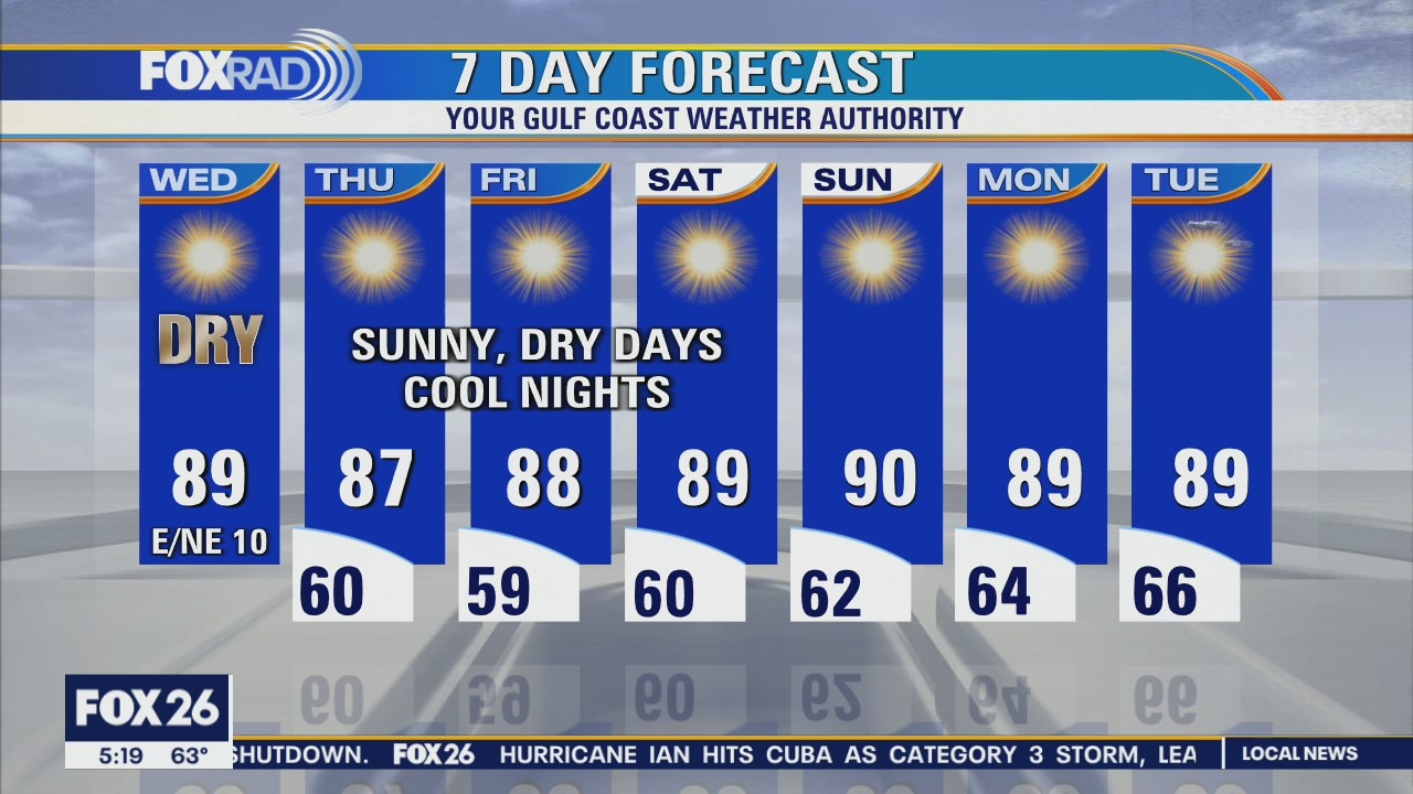
Locally, we couldn't ask for nicer weather. Expect clear, cool nights with warm and dry days taking us all the way through the weekend and much of next week. On the other side of the Gulf, Hurricane Ian is a large, intense hurricane and will bring damaging winds, heavy rain and a huge storm surge to Southwest Florida all day Wednesday and inland to the Orlando area through Thursday.
Locally, we couldn't ask for nicer weather. Expect clear, cool nights with warm and dry days taking us all the way through the weekend and much of next week. On the other side of the Gulf, Hurricane Ian is a large, intense hurricane and will bring damaging winds, heavy rain and a huge storm surge to Southwest Florida all day Wednesday and inland to the Orlando area through Thursday.
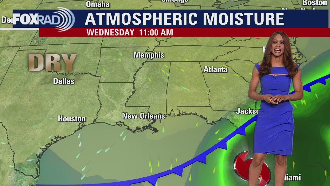
Wednesday morning weather forecast
Phenomenal weather persists for Houston and the rest of SE Texas with high pressure in control and very dry air in place. We'll have pleasant nights in the 50s and 60s through the end of the week and near average high temperatures in the afternoon near 90. Hurricane Ian remains a very dangerous major Category 3 hurricane in the SE Gulf of Mexico growing stronger and getting closer to Florida. Hurricane warnings remain in place for Tampa and Fort Myers, where major flooding, storm surge, hurricane force winds and possible tornadoes are expected.
Phenomenal weather persists for Houston and the rest of SE Texas with high pressure in control and very dry air in place. We'll have pleasant nights in the 50s and 60s through the end of the week and near average high temperatures in the afternoon near 90. Hurricane Ian remains a very dangerous major Category 3 hurricane in the SE Gulf of Mexico growing stronger and getting closer to Florida. Hurricane warnings remain in place for Tampa and Fort Myers, where major flooding, storm surge, hurricane force winds and possible tornadoes are expected.
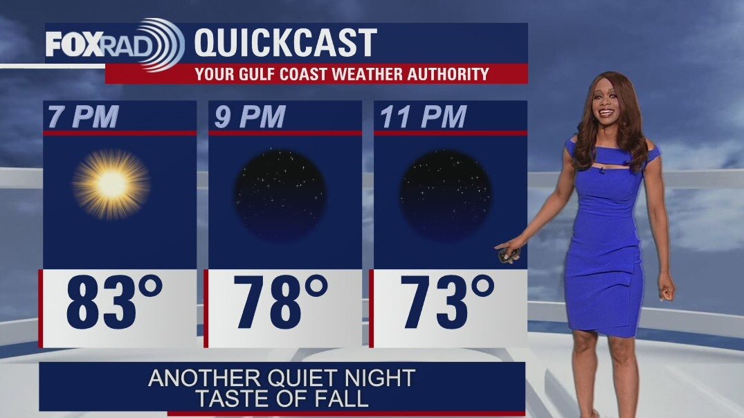
Tuesday evening weather forecast
Phenomenal weather persists for Houston and the rest of SE Texas with high pressure in control and very dry air in place. We'll have pleasant nights in the 50s and 60s through the end of the week and near average high temperatures in the afternoon near 90. Hurricane Ian remains a very dangerous major Category 3 hurricane in the SE Gulf of Mexico growing stronger and getting closer to Florida. Hurricane warnings remain in place for Tampa and Fort Myers, where major flooding, storm surge, hurricane force winds and possible tornadoes are expected.
Phenomenal weather persists for Houston and the rest of SE Texas with high pressure in control and very dry air in place. We'll have pleasant nights in the 50s and 60s through the end of the week and near average high temperatures in the afternoon near 90. Hurricane Ian remains a very dangerous major Category 3 hurricane in the SE Gulf of Mexico growing stronger and getting closer to Florida. Hurricane warnings remain in place for Tampa and Fort Myers, where major flooding, storm surge, hurricane force winds and possible tornadoes are expected.
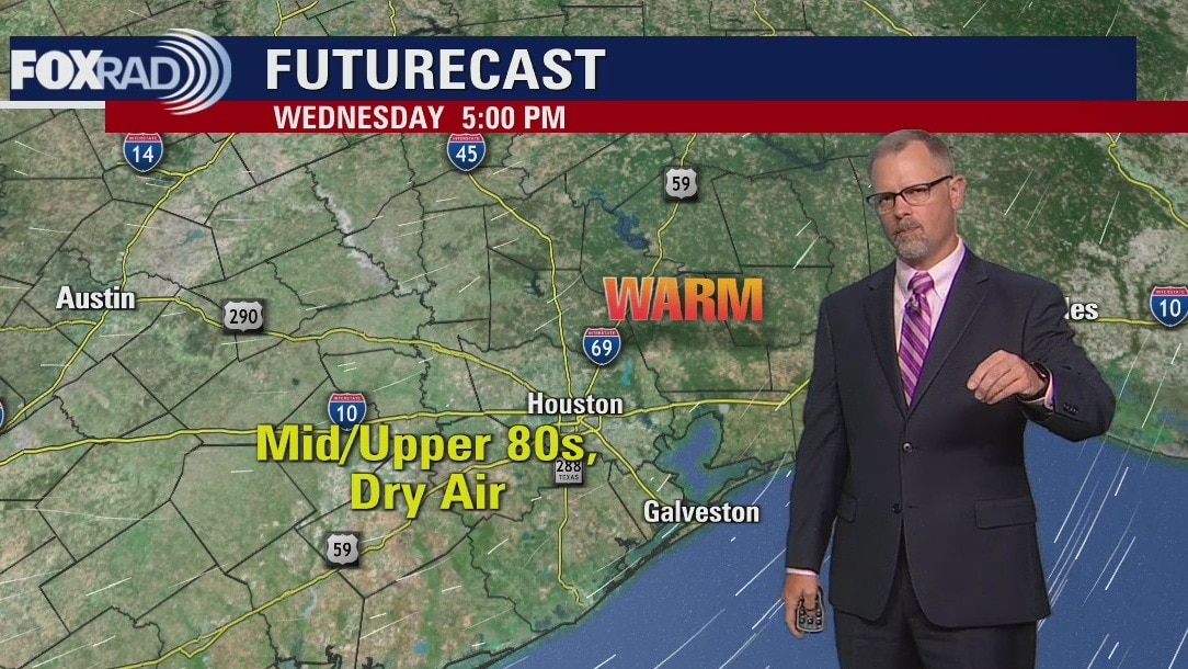
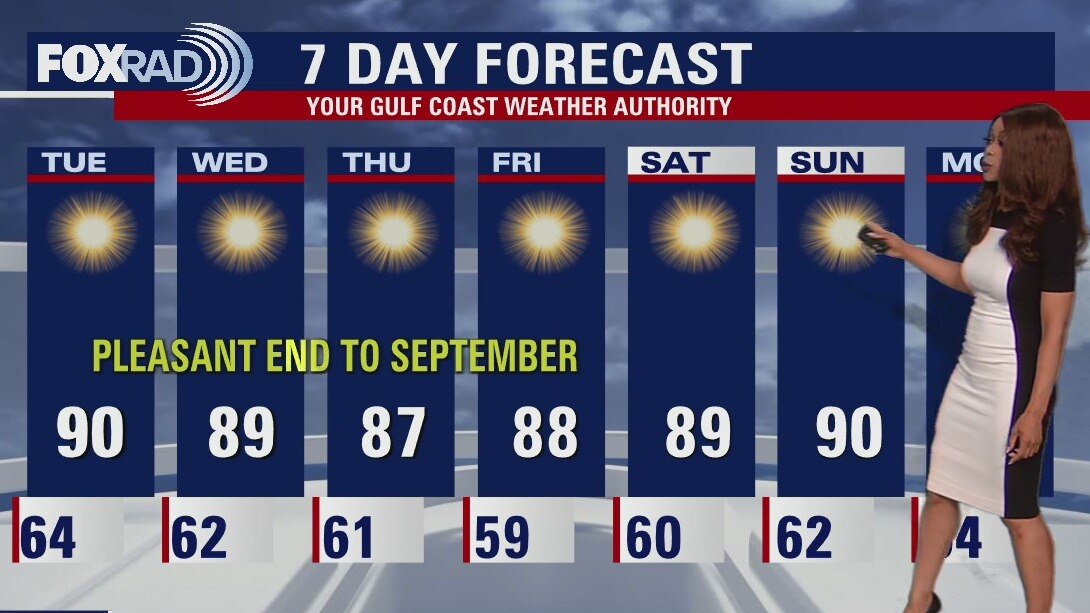
Expect a warm and dry Tuesday afternoon in the upper 80s
As evacuations take place on the Gulf Coast of Florida, the weather in our area couldn't be nicer. We woke up to 50s and 60s this morning and each afternoon for the rest of the week will be sunny, warm, and very dry with highs in the upper 80s. Hurricane Ian is expected to slam the west coast of Florida with major hurricane winds, a damaging storm surge, and more than 10" of rain through the day Wednesday and Thursday.
As evacuations take place on the Gulf Coast of Florida, the weather in our area couldn't be nicer. We woke up to 50s and 60s this morning and each afternoon for the rest of the week will be sunny, warm, and very dry with highs in the upper 80s. Hurricane Ian is expected to slam the west coast of Florida with major hurricane winds, a damaging storm surge, and more than 10" of rain through the day Wednesday and Thursday.
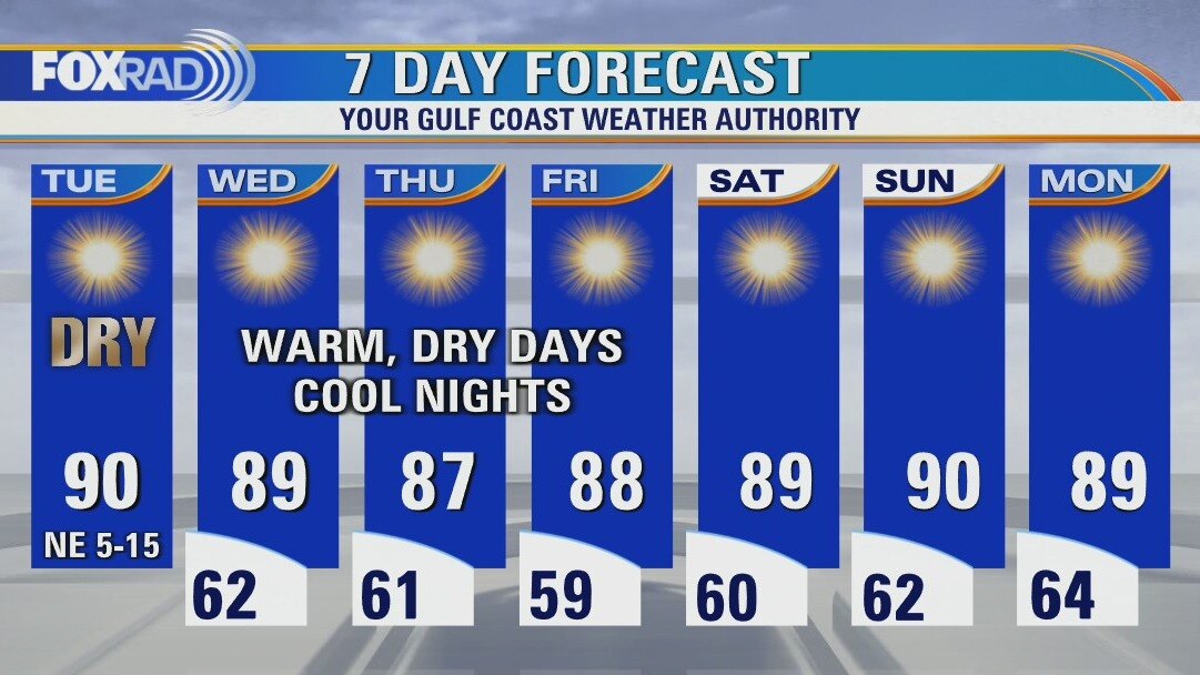
Cooler Tuesday morning, then sunny and dry with highs near 90
As evacuations take place on the Gulf Coast of Florida, weather in our area couldn't be nicer. We woke up to 50s and 60s this morning and that trend will continue for the rest of the week. Each afternoon will be sunny, warm and very dry with highs in the upper 80s, Hurricane Ian is expected to slam the west coast of Florida with major hurricane winds, a damaging storm surge and more than 10" of rain through the day Wednesday and Thursday.
As evacuations take place on the Gulf Coast of Florida, weather in our area couldn't be nicer. We woke up to 50s and 60s this morning and that trend will continue for the rest of the week. Each afternoon will be sunny, warm and very dry with highs in the upper 80s, Hurricane Ian is expected to slam the west coast of Florida with major hurricane winds, a damaging storm surge and more than 10" of rain through the day Wednesday and Thursday.
Monday evening weather forecast
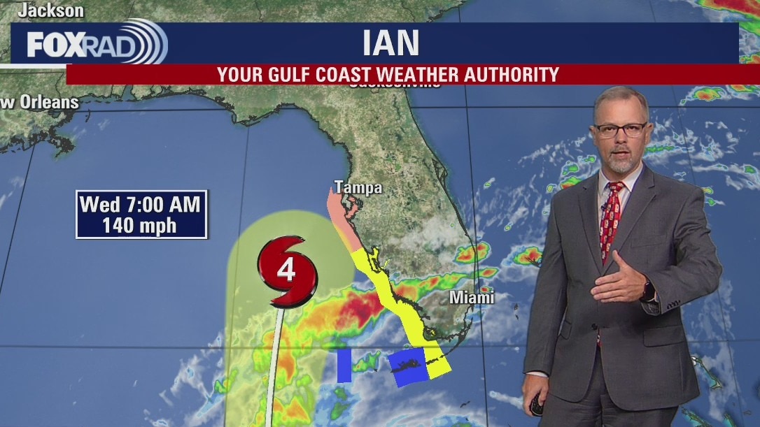
Weak cold front is pushing through which will bring a noticeable difference in the form of lower humidity. Temperatures will remain warm for the rest of the week in the afternoon near 90. But overnight lows will be pleasant in the 50s and 60s. Look for bright sunshine as high pressure dominates. Hurricane Ian will be no threat for SE TX but will have huge impacts in Florida and other parts of the SE over the coming days. Ian is forecast to strengthen to a major hurricane by Tuesday and head over to the western Florida Gulf coast by late Wednesday & early Thursday.
Weak cold front is pushing through which will bring a noticeable difference in the form of lower humidity. Temperatures will remain warm for the rest of the week in the afternoon near 90. But overnight lows will be pleasant in the 50s and 60s. Look for bright sunshine as high pressure dominates. Hurricane Ian will be no threat for SE TX but will have huge impacts in Florida and other parts of the SE over the coming days. Ian is forecast to strengthen to a major hurricane by Tuesday and head over to the western Florida Gulf coast by late Wednesday & early Thursday.
Expect high temps and clear skies this Monday afternoon
Cooler air is on the way! As Hurricane Ian gains strength and threatens to bring heavy rain and a serious storm surge to Florida, our weather will be the complete opposite. Expect sunshine and increasingly dry air with overnight lows in the 50s and 60s! Today will be hot, but with drier air moving in from the north.
Cooler air is on the way! As Hurricane Ian gains strength and threatens to bring heavy rain and a serious storm surge to Florida, our weather will be the complete opposite. Expect sunshine and increasingly dry air with overnight lows in the 50s and 60s! Today will be hot, but with drier air moving in from the north.
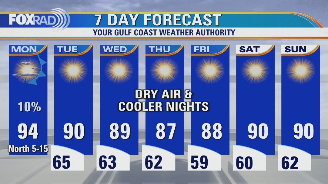
Muggy Monday morning, then sunny, hot and much less humid
Cooler air is on the way! As Hurricane Ian gains strength and threatens to bring heavy rain and serious storm surge to Florida, our weather will be the complete opposite. Expect sunshine and increasingly dry air with overnight lows in the 50s and 60s! Today will be hot, but with drier air moving in from the north.
Cooler air is on the way! As Hurricane Ian gains strength and threatens to bring heavy rain and serious storm surge to Florida, our weather will be the complete opposite. Expect sunshine and increasingly dry air with overnight lows in the 50s and 60s! Today will be hot, but with drier air moving in from the north.
Sunday night leading into Monday morning weather forecast
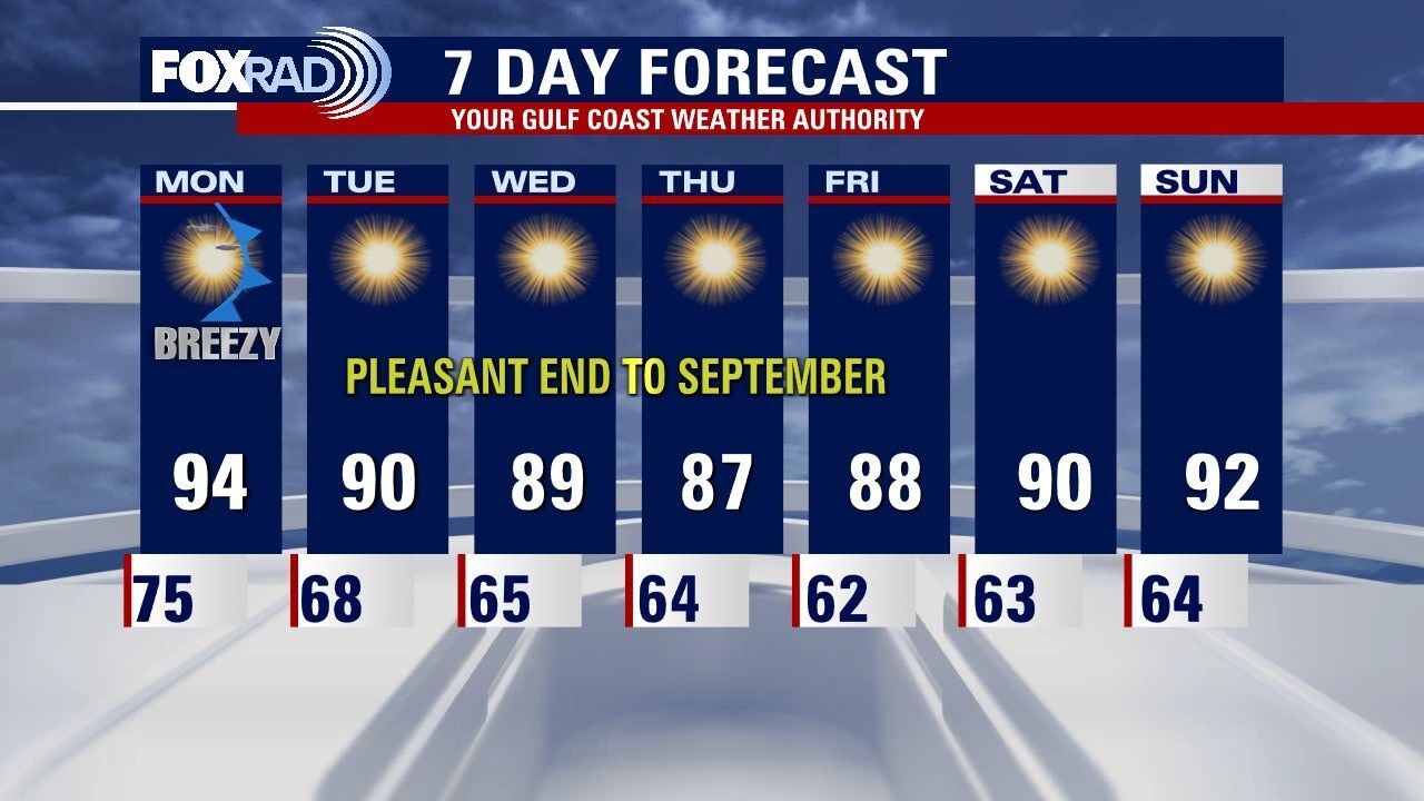
The unusually hot temperatures over the weekend should start to transition back to normal on Monday. The mornings in Houston will be noticeably drier and cooler starting on Tuesday. The pleasant, less humid patter will set in for the rest of the week. Make plans to enjoy some dry afternoons with high temperatures only in the 80s!
The unusually hot temperatures over the weekend should start to transition back to normal on Monday. The mornings in Houston will be noticeably drier and cooler starting on Tuesday. The pleasant, less humid patter will set in for the rest of the week. Make plans to enjoy some dry afternoons with high temperatures only in the 80s!

Sunday Morning Forecast with Meteorologist Lena Maria Arango
One last warm day, and then tomorrow the transition begins. Plan for a bit of a breeze as the front works its way through our area on Monday, though rain chances are looking minimal at best. Come Tuesday, a blissful less humid weather pattern sets in for the remainder of the week. Our highs will be near average, and our morning lows will actually be slightly below! In the tropics, Ian is set to rapidly intensify today eventually becoming a major hurricane before impacting Florida midweek. There are no concerns for Texas, and things in the rest of the Atlantic basin continue to fizzle out.
One last warm day, and then tomorrow the transition begins. Plan for a bit of a breeze as the front works its way through our area on Monday, though rain chances are looking minimal at best. Come Tuesday, a blissful less humid weather pattern sets in for the remainder of the week. Our highs will be near average, and our morning lows will actually be slightly below! In the tropics, Ian is set to rapidly intensify today eventually becoming a major hurricane before impacting Florida midweek. There are no concerns for Texas, and things in the rest of the Atlantic basin continue to fizzle out.
Saturday night leading into Sunday morning weather forecast
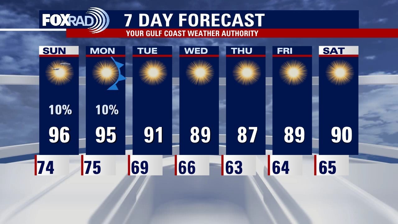
Houston will end the weekend a lot as it started. Sunday morning will see temperatures in the mid-70s with afternoon highs in the mid-90s. The abnormally hot September weather gradually fades as we move through the week. Look for conditions to seem more appropriate for the calendar starting on Wednesday.
Houston will end the weekend a lot as it started. Sunday morning will see temperatures in the mid-70s with afternoon highs in the mid-90s. The abnormally hot September weather gradually fades as we move through the week. Look for conditions to seem more appropriate for the calendar starting on Wednesday.

Your Saturday Morning Forecast with Meteorologist Lena Maria Arango
Fall may be late to the party, but is scheduled to make a fashionably late arrival by middle of next week. We have an approaching cold front to thank for that, which will also help to keep now Tropical Storm Ian east of southeast Texas. Until then, though toasty temps remain for your weekend plans. The presence of high pressure leading into the arrival of the front means that we don't have much moisture to work with. So, we won't see much in the way of rain over the course of the next week.
Fall may be late to the party, but is scheduled to make a fashionably late arrival by middle of next week. We have an approaching cold front to thank for that, which will also help to keep now Tropical Storm Ian east of southeast Texas. Until then, though toasty temps remain for your weekend plans. The presence of high pressure leading into the arrival of the front means that we don't have much moisture to work with. So, we won't see much in the way of rain over the course of the next week.