

Sunday Morning Forecast with Meteorologist Lena Maria
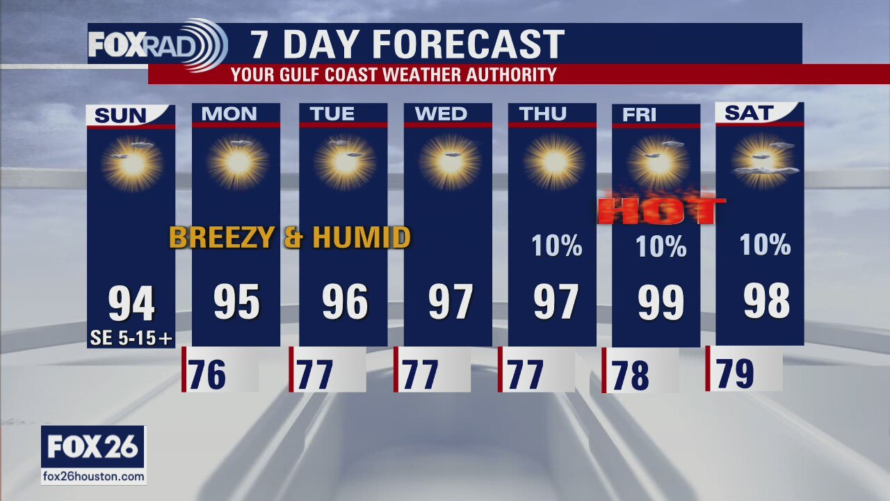
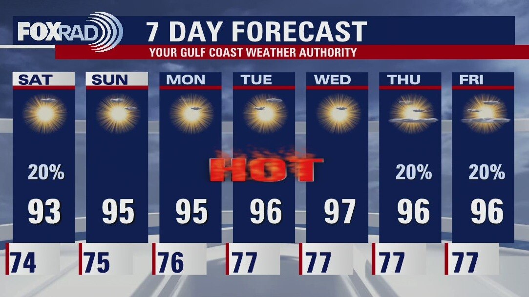
The pattern for this week is HOT and generally rain free. Actual daytime highs will flirt with triple digits, with heat indices 100+ for most of the week. Keep an eye out for heat advisories, as they may get issued. Gulf breezes return this afternoon, ushering in a more humid airmass. But we'll only be lucky, at best to trigger some daily showers toward the tail end of the week. Keep heat safety at top of mind for any outdoor activities, especially strenuous ones during the hottest time of the day. Oh, and... we finally have our first named storm of the 2022 Atlantic Hurricane Season. The disturbance that brought flooding rains to Florida, is now Alex over open ocean waters with the only potential threat to land at this point being Bermuda.
The pattern for this week is HOT and generally rain free. Actual daytime highs will flirt with triple digits, with heat indices 100+ for most of the week. Keep an eye out for heat advisories, as they may get issued. Gulf breezes return this afternoon, ushering in a more humid airmass. But we'll only be lucky, at best to trigger some daily showers toward the tail end of the week. Keep heat safety at top of mind for any outdoor activities, especially strenuous ones during the hottest time of the day. Oh, and... we finally have our first named storm of the 2022 Atlantic Hurricane Season. The disturbance that brought flooding rains to Florida, is now Alex over open ocean waters with the only potential threat to land at this point being Bermuda.
Saturday evening/Sunday morning weather forecast
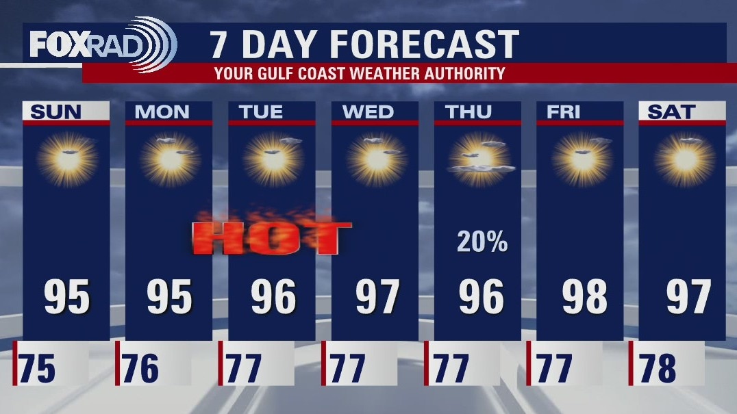
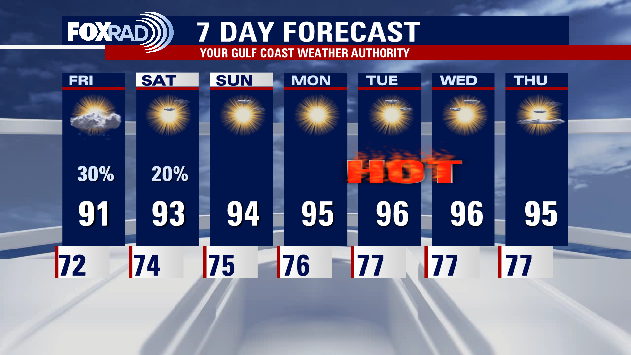
A few scattered showers and thunderstorms are still possible this evening but an overall drier pattern will be setting up for Sunday into much of next week. Hotter temperatures will grip the region with highs soaring into the mid to upper 90s. Gulf breezes return starting tomorrow, allowing for 'feels like; temps to approach 100-105. Make sure you are taking heat safety precautions and drinking plenty of water!
A few scattered showers and thunderstorms are still possible this evening but an overall drier pattern will be setting up for Sunday into much of next week. Hotter temperatures will grip the region with highs soaring into the mid to upper 90s. Gulf breezes return starting tomorrow, allowing for 'feels like; temps to approach 100-105. Make sure you are taking heat safety precautions and drinking plenty of water!
Saturday Morning Forecast with Meteorologist Lena Maria
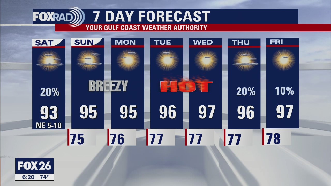
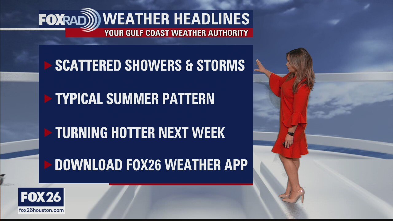
A warm, typical summer like weekend is setting up across southeast Texas as we transition from a bit of an unsettled pattern to a hot and dry one. Hit or miss showers will be in the vicinity today, mainly south of I-10. No need to cancel outdoor plans but you may have to dodge a quick moving shower this afternoon-evening. Tomorrow, we crank up the heat as gulf breezes return and humidity will have things feeling like 100+ for much of next week. Speaking of 100, we may tap our first triple digit day next week in some locations... and even if we don't, we'll certainly come close.
A warm, typical summer like weekend is setting up across southeast Texas as we transition from a bit of an unsettled pattern to a hot and dry one. Hit or miss showers will be in the vicinity today, mainly south of I-10. No need to cancel outdoor plans but you may have to dodge a quick moving shower this afternoon-evening. Tomorrow, we crank up the heat as gulf breezes return and humidity will have things feeling like 100+ for much of next week. Speaking of 100, we may tap our first triple digit day next week in some locations... and even if we don't, we'll certainly come close.
Saturday morning weather forecast
The first weekend of June is looking hot! An isolated shower or thunderstorm is still possible tomorrow but most locations will get away with a dry sun-filled day. Gulf breezes will return leading to slightly higher humidity across the region. Temperatures will be climbing too! Highs will soar into the mid 90s each day next week.
The first weekend of June is looking hot! An isolated shower or thunderstorm is still possible tomorrow but most locations will get away with a dry sun-filled day. Gulf breezes will return leading to slightly higher humidity across the region. Temperatures will be climbing too! Highs will soar into the mid 90s each day next week.
Friday evening weather forecast
The first weekend of June is looking hot! An isolated shower or thunderstorm is still possible tomorrow but most locations will get away with a dry sun-filled day. Gulf breezes will return leading to slightly higher humidity across the region. Temperatures will be climbing too! Highs will soar into the mid 90s each day next week.
The first weekend of June is looking hot! An isolated shower or thunderstorm is still possible tomorrow but most locations will get away with a dry sun-filled day. Gulf breezes will return leading to slightly higher humidity across the region. Temperatures will be climbing too! Highs will soar into the mid 90s each day next week.
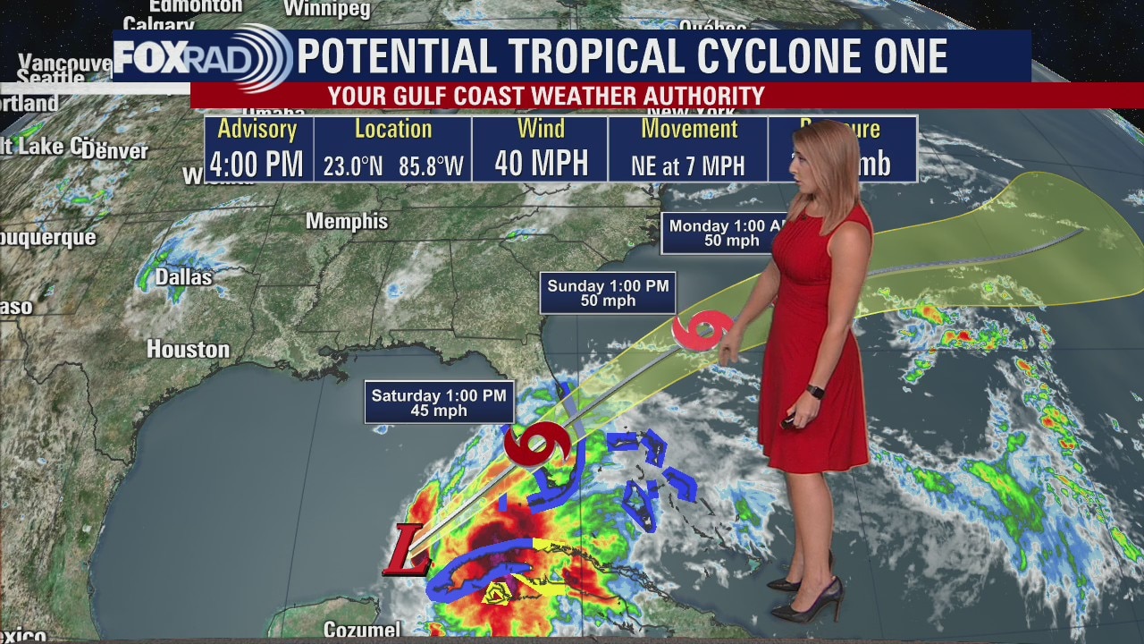
Tropical Weather Forecast - June 3, 2022
Potential Tropical Cyclone One remains disorganized. The system has picked up a bit of speed, spreading heavy rain across Florida and Cuba with flooding possible. Tropical storm watches and warnings have been posted for those locations.
Potential Tropical Cyclone One remains disorganized. The system has picked up a bit of speed, spreading heavy rain across Florida and Cuba with flooding possible. Tropical storm watches and warnings have been posted for those locations.
Mostly sunny skies ahead
An isolated shower or storm cannot be ruled out today, and tomorrow with a weak boundary lingering in the vicinity. Plan for mostly sunny skies, and warm temperatures that will be on the rise through next week. Gulf breezes will return over the weekend leading to slightly higher humidity, but overall we are entering into another sunny and dry stretch. Late next week, rain chances may introduce themselves.
An isolated shower or storm cannot be ruled out today, and tomorrow with a weak boundary lingering in the vicinity. Plan for mostly sunny skies, and warm temperatures that will be on the rise through next week. Gulf breezes will return over the weekend leading to slightly higher humidity, but overall we are entering into another sunny and dry stretch. Late next week, rain chances may introduce themselves.

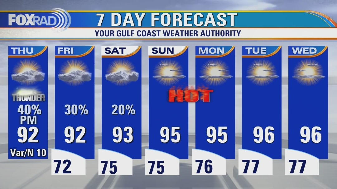
Thursday night leading into Friday morning weather forecast
A weak cold front continues to drift into our area, bringing a few scattered showers and thunderstorms. Look for a couple of additional showers and thunderstorms again tomorrow afternoon and evening. We'll trend drier and hotter this weekend as Gulf breezes return by Sunday. Highs will soar into the mid-90s through much of next week.
A weak cold front continues to drift into our area, bringing a few scattered showers and thunderstorms. Look for a couple of additional showers and thunderstorms again tomorrow afternoon and evening. We'll trend drier and hotter this weekend as Gulf breezes return by Sunday. Highs will soar into the mid-90s through much of next week.
Thursday evening weather forecast with Meteorologist Adrienne Vonn
A weak cold front continues to drift into our area, bringing a few scattered showers and thunderstorms. Look for a couple of additional showers and thunderstorms again tomorrow afternoon and evening. We'll trend drier and hotter this weekend as Gulf breezes return by Sunday. Highs will soar into the mid-90s through much of next week.
A weak cold front continues to drift into our area, bringing a few scattered showers and thunderstorms. Look for a couple of additional showers and thunderstorms again tomorrow afternoon and evening. We'll trend drier and hotter this weekend as Gulf breezes return by Sunday. Highs will soar into the mid-90s through much of next week.
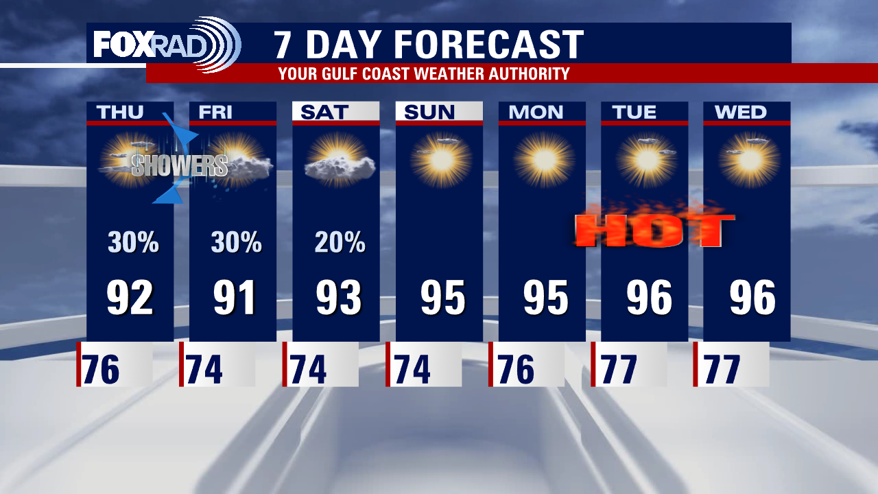
Weak cold front bringing rain
A weak cold front will bring a broken line of non-severe storms through this evening, with pockets of locally heavy rainfall possible. Isolated showers linger on Friday, and Saturday while the front retreats northward as a warm front. Gulf breezes return by Sunday, along with lots of sunshine and increasing temperatures. Soon to be Alex will bring downpours to Cuba, southern Florida and eventually the Bahamas over the weekend but the tropics are quiet aside from that.
A weak cold front will bring a broken line of non-severe storms through this evening, with pockets of locally heavy rainfall possible. Isolated showers linger on Friday, and Saturday while the front retreats northward as a warm front. Gulf breezes return by Sunday, along with lots of sunshine and increasing temperatures. Soon to be Alex will bring downpours to Cuba, southern Florida and eventually the Bahamas over the weekend but the tropics are quiet aside from that.
Thursday afternoon weather forecast
Following a round of some healthy tropical downpours in parts of the area yesterday, a weak cold front is expected bring some scattered storms for the Houston-Galveston area. A couple of them could drop more than an inch of rain. Look for another chance for scattered showers tomorrow with a gradual warmer, sunnier pattern kicking in this weekend and next week. Highs could reach the mid to upper 90s each day beginning Sunday.
Following a round of some healthy tropical downpours in parts of the area yesterday, a weak cold front is expected bring some scattered storms for the Houston-Galveston area. A couple of them could drop more than an inch of rain. Look for another chance for scattered showers tomorrow with a gradual warmer, sunnier pattern kicking in this weekend and next week. Highs could reach the mid to upper 90s each day beginning Sunday.

Wednesday night leading into Thursday morning weather forecast
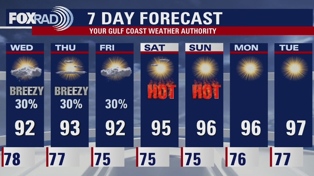
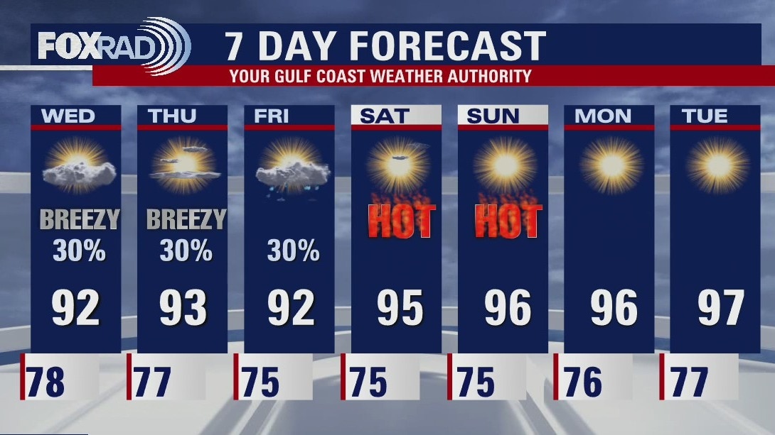
Scattered showers and storms will be possible through the end of the week. Temperatures will remain toasty with highs climbing into the low 90s. A weak front will fizzle out over us in the late week but quickly lifts northward again as a warm front. High heat and humidity continue this weekend as a ridge builds into next week, allowing for plenty of sunshine.
Scattered showers and storms will be possible through the end of the week. Temperatures will remain toasty with highs climbing into the low 90s. A weak front will fizzle out over us in the late week but quickly lifts northward again as a warm front. High heat and humidity continue this weekend as a ridge builds into next week, allowing for plenty of sunshine.
Wednesday evening weather forecast with Meteorologist Adrienne Vonn
Scattered showers and storms will be possible through the end of the week. Temperatures will remain toasty with highs climbing into the low 90s. A weak front will fizzle out over us in the late week but quickly lifts northward again as a warm front. High heat and humidity continue this weekend as a ridge builds into next week, allowing for plenty of sunshine.
Scattered showers and storms will be possible through the end of the week. Temperatures will remain toasty with highs climbing into the low 90s. A weak front will fizzle out over us in the late week but quickly lifts northward again as a warm front. High heat and humidity continue this weekend as a ridge builds into next week, allowing for plenty of sunshine.
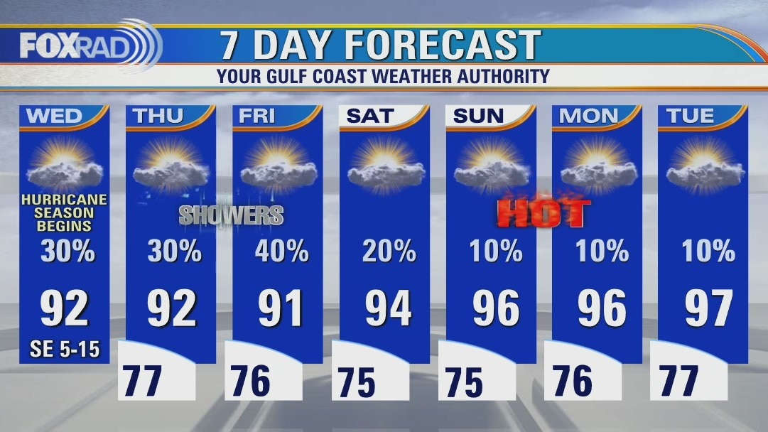
Wednesday afternoon weather forecast
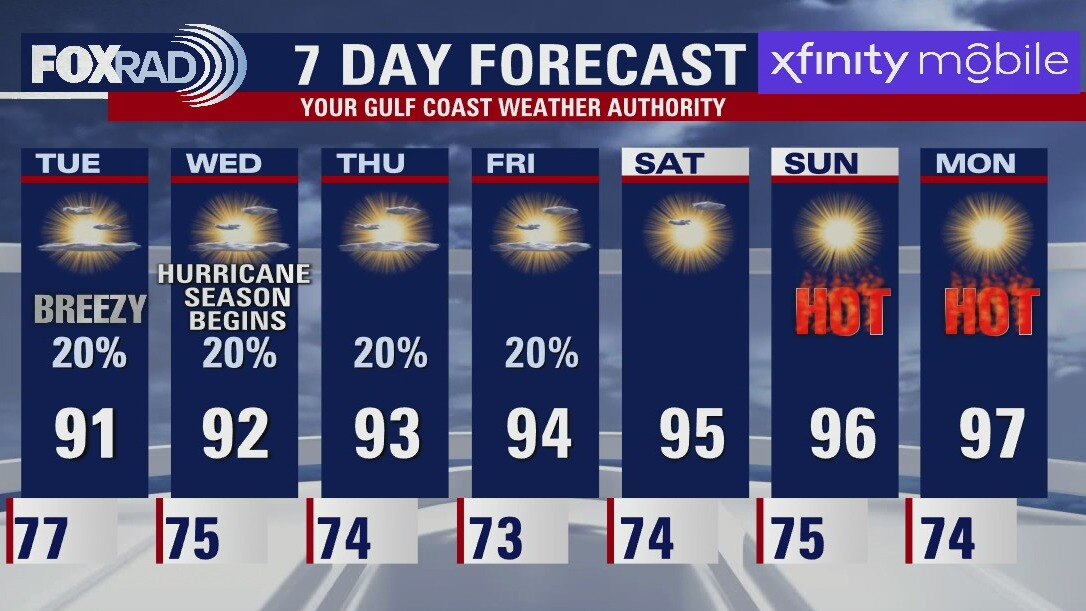
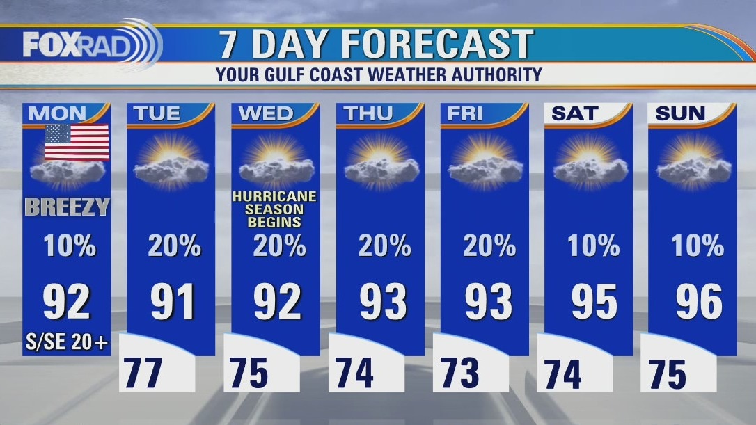
On this first day of hurricane season, there aren't any tropical threats for Texas, but an early season tropical depression could bring rainy weather to Florida through this weekend. Locally, look for typical early June weather with scattered showers and muggy air. Early next week looks a bit hotter with lower rain chances.
On this first day of hurricane season, there aren't any tropical threats for Texas, but an early season tropical depression could bring rainy weather to Florida through this weekend. Locally, look for typical early June weather with scattered showers and muggy air. Early next week looks a bit hotter with lower rain chances.
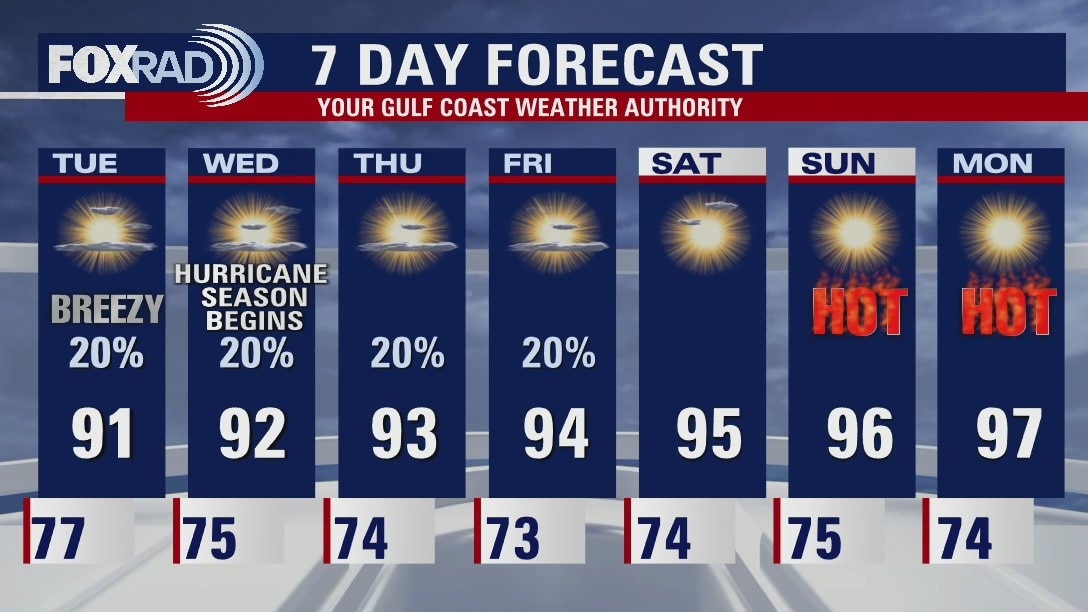
Wednesday morning weather forecast
The weather will be very "June like" as we finish up this week. Muggy mornings followed by warm afternoons with isolated chances for showers or downpours. Overall the temperatures will be running a couple degrees above the seasonal norms. This weekend will be hot for Houston. Southeast Texas will see fewer chances for rain on Saturday and Sunday will even warmer afternoons. There are no tropical threats for our area at this time.
The weather will be very "June like" as we finish up this week. Muggy mornings followed by warm afternoons with isolated chances for showers or downpours. Overall the temperatures will be running a couple degrees above the seasonal norms. This weekend will be hot for Houston. Southeast Texas will see fewer chances for rain on Saturday and Sunday will even warmer afternoons. There are no tropical threats for our area at this time.
Tuesday evening weather forecast
The weather will be very "June-like" as we finish up this week. Muggy mornings followed by warm afternoons with isolated chances for showers or downpours. Overall the temperatures will be running a couple of degrees above the seasonal norms. This weekend will be hot for Houston. Southeast Texas will see fewer chances for rain on Saturday and Sunday will even warmer afternoons. There are no tropical threats for our area at this time.
The weather will be very "June-like" as we finish up this week. Muggy mornings followed by warm afternoons with isolated chances for showers or downpours. Overall the temperatures will be running a couple of degrees above the seasonal norms. This weekend will be hot for Houston. Southeast Texas will see fewer chances for rain on Saturday and Sunday will even warmer afternoons. There are no tropical threats for our area at this time.
Tuesday afternoon weather forecat
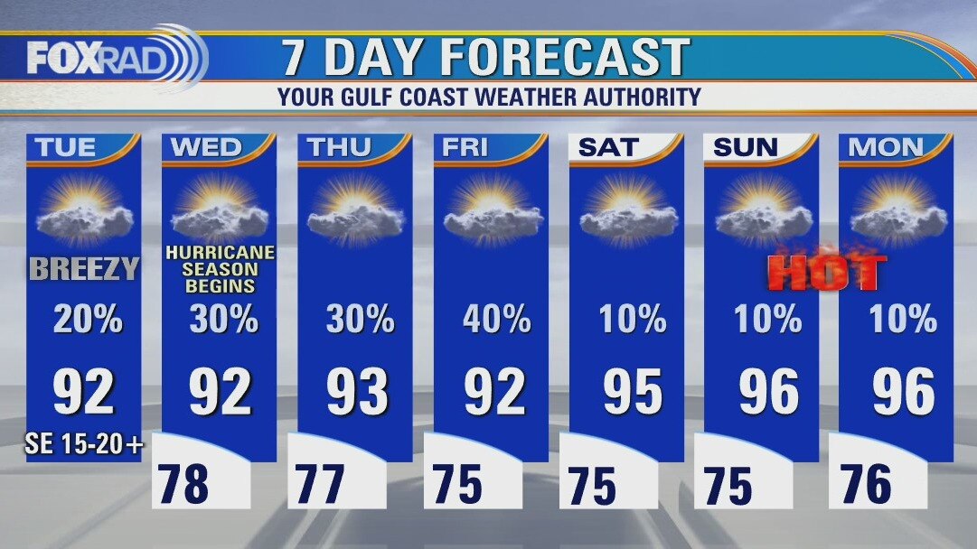
As we wrap up the month of May and head into June, our pattern looks fairly typical for this time of year, albeit slightly warmer than normal. Look for highs in the low to mid 90s with breezy southeast winds and isolated showers. A few storms are possible Wednesday through Friday, but not looking widespread. Planning for this weekend? Expect hotter weather with highs in the mid 90s and a heat index above 100. There are no tropical threats for our area at this time.
As we wrap up the month of May and head into June, our pattern looks fairly typical for this time of year, albeit slightly warmer than normal. Look for highs in the low to mid 90s with breezy southeast winds and isolated showers. A few storms are possible Wednesday through Friday, but not looking widespread. Planning for this weekend? Expect hotter weather with highs in the mid 90s and a heat index above 100. There are no tropical threats for our area at this time.
Tuesday morning weather forecast
The warm and dry weather continues for Southeast Texas. An isolated afternoon shower/storm could be seen around Houston this week but most will only see partly cloudy skies. Next weekend will heat up even more with less chance for rain.
The warm and dry weather continues for Southeast Texas. An isolated afternoon shower/storm could be seen around Houston this week but most will only see partly cloudy skies. Next weekend will heat up even more with less chance for rain.
Monday evening weather forecast
The warm and dry weather continues for Southeast Texas. An isolated afternoon shower/storm could be seen around Houston this week but most will only see partly cloudy skies. Next weekend will heat up even more with less chance for rain.
The warm and dry weather continues for Southeast Texas. An isolated afternoon shower/storm could be seen around Houston this week but most will only see partly cloudy skies. Next weekend will heat up even more with less chance for rain.
Monday afternoon weather forecast
Memorial Day is shaping up to be very warm and breezy with a few small, quick-moving sprinkles possible. Other than that, look for a heat index near 100, but with a nice breeze. The rest of the week should be fairly similar with highs in the low to mid 90s, lows in the upper 70s and a few isolated showers each day. Hurricane Agatha will soak southern Mexico over the next couple of days, but is not expected to affect our weather.
Memorial Day is shaping up to be very warm and breezy with a few small, quick-moving sprinkles possible. Other than that, look for a heat index near 100, but with a nice breeze. The rest of the week should be fairly similar with highs in the low to mid 90s, lows in the upper 70s and a few isolated showers each day. Hurricane Agatha will soak southern Mexico over the next couple of days, but is not expected to affect our weather.