

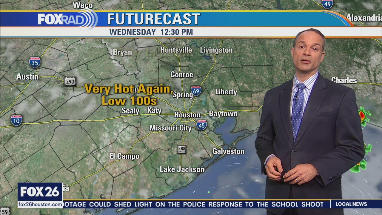
Another hot day in the low 100s
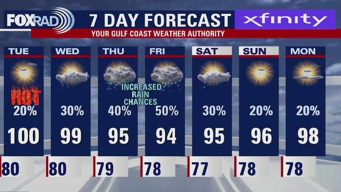
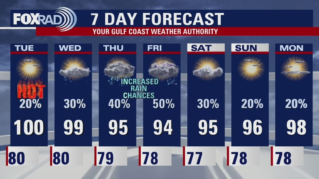
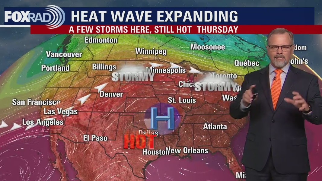
Houston has hit 100 degrees or higher for five days in a row and today will likely make day six. Look for highs in the low 100s with only isolated late-day storms. Tomorrow could get interesting with three of our short-term models all picking up on a complex of storms beginning near Atlanta and moving toward Houston overnight tonight and into midday Thursday. Other than that, the song remains the same - high heat, humidity and isolated afternoon storms.
Houston has hit 100 degrees or higher for five days in a row and today will likely make day six. Look for highs in the low 100s with only isolated late-day storms. Tomorrow could get interesting with three of our short-term models all picking up on a complex of storms beginning near Atlanta and moving toward Houston overnight tonight and into midday Thursday. Other than that, the song remains the same - high heat, humidity and isolated afternoon storms.
Wednesday morning weather forecast
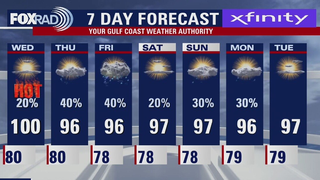
As we continue through the rest of the week, a slightly less intense version of heat looks to continue. Some of us may squeeze out another 100 degree day or two especially farther inland. At least scattered shower and storm chances remain in the forecast daily! While still above average, enjoy the slightly subdued temperatures while they last. More 100s look apparent in our near future with another hot and dry pattern on the horizon.
As we continue through the rest of the week, a slightly less intense version of heat looks to continue. Some of us may squeeze out another 100 degree day or two especially farther inland. At least scattered shower and storm chances remain in the forecast daily! While still above average, enjoy the slightly subdued temperatures while they last. More 100s look apparent in our near future with another hot and dry pattern on the horizon.
Tuesday evening weather forecast
As we continue through the rest of the week, a slightly less intense version of heat looks to continue. Some of us may squeeze out another 100-degree day or two especially farther inland. At least scattered shower and storm chances remain in the forecast daily! While still above average, enjoy the slightly subdued temperatures while they last. More 100s look apparent in our near future with another hot and dry pattern on the horizon.
As we continue through the rest of the week, a slightly less intense version of heat looks to continue. Some of us may squeeze out another 100-degree day or two especially farther inland. At least scattered shower and storm chances remain in the forecast daily! While still above average, enjoy the slightly subdued temperatures while they last. More 100s look apparent in our near future with another hot and dry pattern on the horizon.
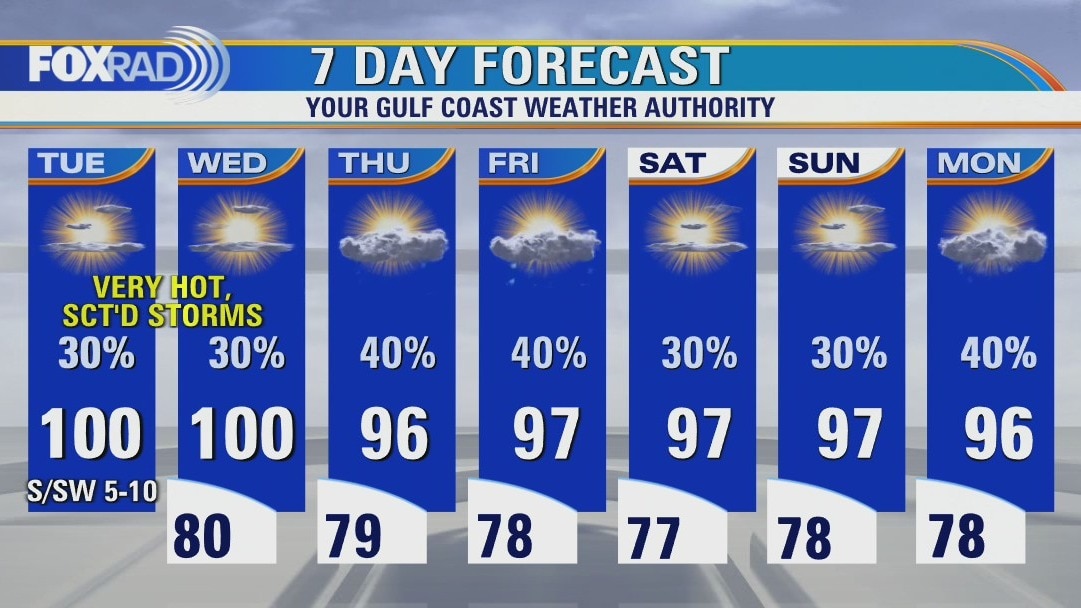
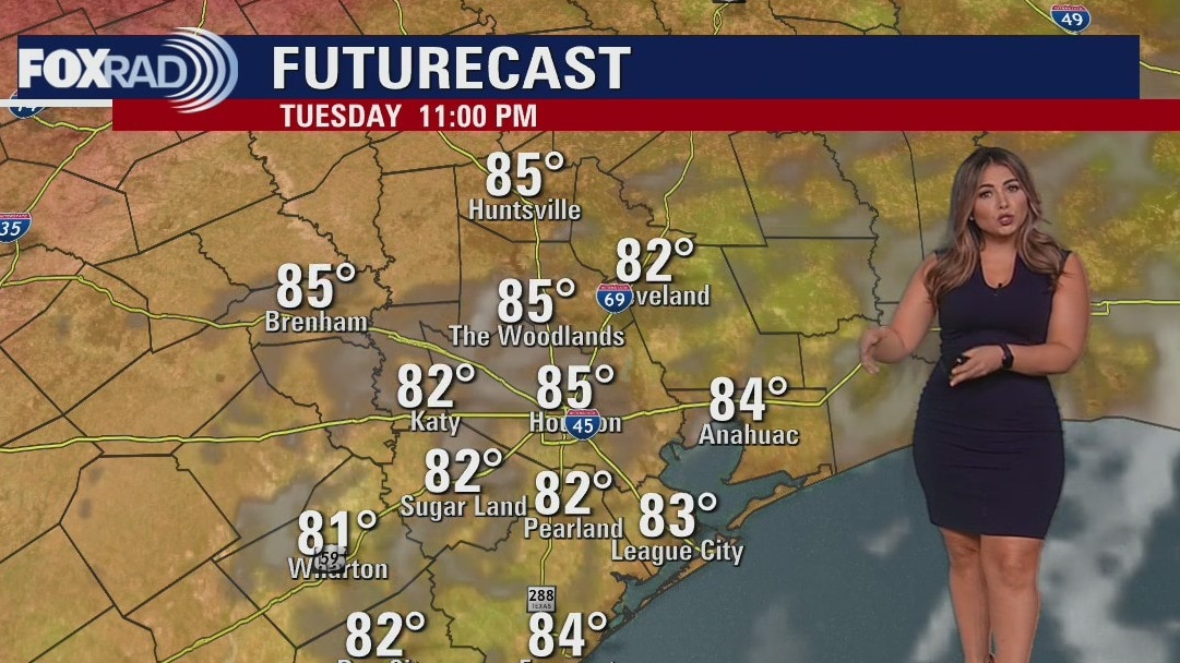
Very hot again Tuesday with some storms
Still no rest for the weary...more triple digit heat lies ahead for us today and probably tomorrow. A heat advisory is in effect once again warning that heat index values could exceed 108�. There is a good chance for late day or evening storms again and some high winds are possible. Otherwise, the main item of interest is a developing low in the Gulf of Mexico south of Alabama and the Florida Panhandle - this low could form into a small tropical depression later this week, but as of today, doesn't look like it's headed our way. Either way, a slight breakdown of our persistent extreme heat is possible with temperatures cooling "all the way down" to the mid 90s with scattered storms.
Still no rest for the weary...more triple digit heat lies ahead for us today and probably tomorrow. A heat advisory is in effect once again warning that heat index values could exceed 108�. There is a good chance for late day or evening storms again and some high winds are possible. Otherwise, the main item of interest is a developing low in the Gulf of Mexico south of Alabama and the Florida Panhandle - this low could form into a small tropical depression later this week, but as of today, doesn't look like it's headed our way. Either way, a slight breakdown of our persistent extreme heat is possible with temperatures cooling "all the way down" to the mid 90s with scattered storms.
Tuesday morning weather forecast
While Tuesday's forecast is not as hot as the last couple of days, it will still be dangerously hot for Southeast Texas. Heat Advisories remain in place across the Houston area. Temperatures will continue to slowly drop through the week and rain chances should increase.
While Tuesday's forecast is not as hot as the last couple of days, it will still be dangerously hot for Southeast Texas. Heat Advisories remain in place across the Houston area. Temperatures will continue to slowly drop through the week and rain chances should increase.
Monday evening weather forecast
While Tuesday's forecast is not as hot as the last couple of days, it will still be dangerously hot for Southeast Texas. Heat Advisories remain in place across the Houston area. Temperatures will continue to slowly drop through the week and rain chances should increase.
While Tuesday's forecast is not as hot as the last couple of days, it will still be dangerously hot for Southeast Texas. Heat Advisories remain in place across the Houston area. Temperatures will continue to slowly drop through the week and rain chances should increase.
Very hot day Monday with isolated late day storms
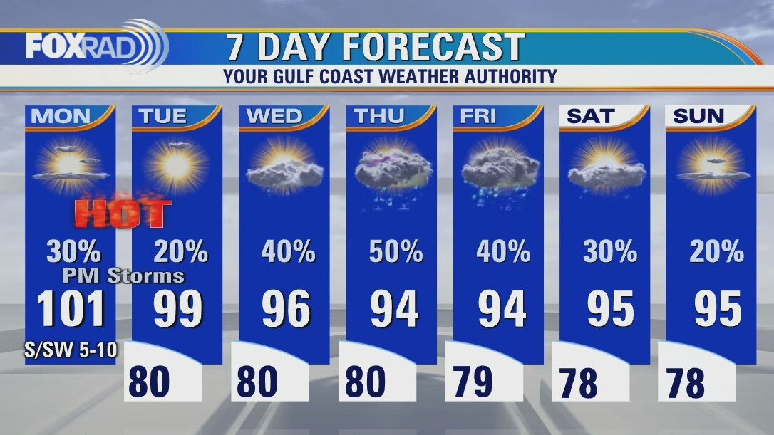
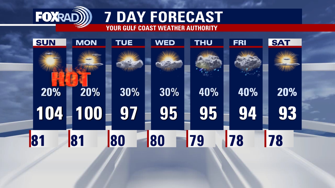
Brace yourself for another very hot day with another chance for late-day and evening storms. A heat advisory is in effect for the Houston area along with an excessive heat warning for communities west of Katy and Hempstead. Today's heat index could hit 110, but watch your FOX 26 weather app for some evening storms. Tomorrow looks very hot as well, but high pressure may start to move westward by later this week, so our temperatures could cool by several degrees. There is a slight chance for a small tropical low to form south of New Orleans this week. Its future motion is unclear, but could bring us some rain by Thursday or Friday.
Brace yourself for another very hot day with another chance for late-day and evening storms. A heat advisory is in effect for the Houston area along with an excessive heat warning for communities west of Katy and Hempstead. Today's heat index could hit 110, but watch your FOX 26 weather app for some evening storms. Tomorrow looks very hot as well, but high pressure may start to move westward by later this week, so our temperatures could cool by several degrees. There is a slight chance for a small tropical low to form south of New Orleans this week. Its future motion is unclear, but could bring us some rain by Thursday or Friday.
Sunday night leading into Monday morning weather forecast
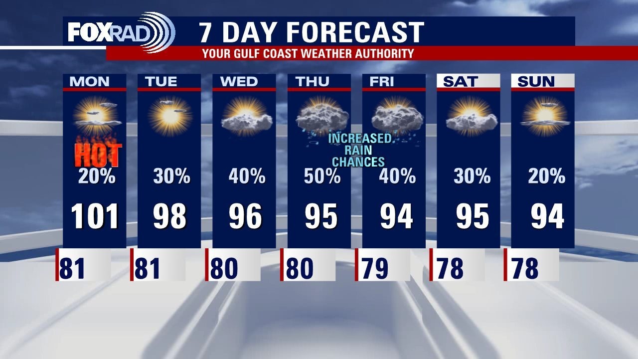
Dangerously heat continues for Monday across Southeast Texas. Excessive Heat Warnings and Heat Advisories will be in place for the FOX 26 area. Isolated showers or storms will start entering the forecast with temperatures slowly declining during the week.
Dangerously heat continues for Monday across Southeast Texas. Excessive Heat Warnings and Heat Advisories will be in place for the FOX 26 area. Isolated showers or storms will start entering the forecast with temperatures slowly declining during the week.
Sunday Morning Forecast with Meteorologist Lena Maria
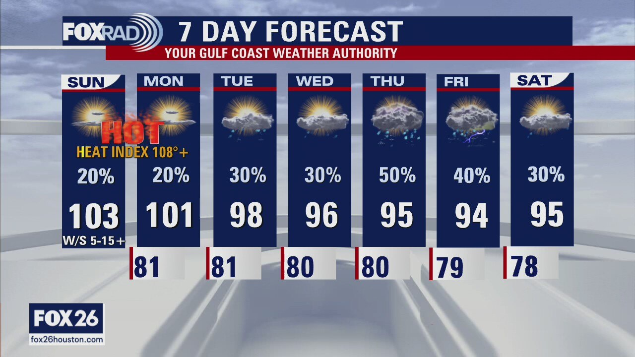
Dangerous heat both continues, and looks to peak today. Exercise extreme caution if spending time outdoors, especially for sensitive populations. A few lucky ones will see an isolated shower or storm today, and a possible stronger storm or downpour may mix down some gusty winds. While rain chances don't look overly impressive this week for now, possibilities at least exist daily and that looks to drive down our temperatures to a more manageable, and seasonable range.
Dangerous heat both continues, and looks to peak today. Exercise extreme caution if spending time outdoors, especially for sensitive populations. A few lucky ones will see an isolated shower or storm today, and a possible stronger storm or downpour may mix down some gusty winds. While rain chances don't look overly impressive this week for now, possibilities at least exist daily and that looks to drive down our temperatures to a more manageable, and seasonable range.
Saturday night leading into Sunday morning weather forecast
Dangerously hot conditions continue tomorrow. Heat advisories have been extended for the entire area thru Sunday evening. Temperatures will soar to record levels and heat index are expected to exceed 108 tomorrow afternoon. A weak boundary nearby may pop off a few isolated thunderstorms but most locations will stay dry. Stay cool everyone!
Dangerously hot conditions continue tomorrow. Heat advisories have been extended for the entire area thru Sunday evening. Temperatures will soar to record levels and heat index are expected to exceed 108 tomorrow afternoon. A weak boundary nearby may pop off a few isolated thunderstorms but most locations will stay dry. Stay cool everyone!

Saturday weather forecast with Meteorologist Lena Maria Arango
This weekend will likely feature our hottest temperatures so far year to date. Heat Advisories blanket the area for most of Saturday, with Excessive Heat Warnings to our north. Monday still looks hot for many, and potentially even Tuesday but depending on how things begin to shift we can expect a gradual cooldown next week. An increase in clouds, and rain chances will help keep temperatures at bay. In the mean time -- take it easy out there!
This weekend will likely feature our hottest temperatures so far year to date. Heat Advisories blanket the area for most of Saturday, with Excessive Heat Warnings to our north. Monday still looks hot for many, and potentially even Tuesday but depending on how things begin to shift we can expect a gradual cooldown next week. An increase in clouds, and rain chances will help keep temperatures at bay. In the mean time -- take it easy out there!
Saturday morning weather forecast
Dangerously hot conditions are setting up for the weekend. Heat advisories have been posted for Saturday with highs closing in on record territory and heat index values approaching 110. Scorching heat continues on Sunday with temperatures again soaring into the triple digits. Make sure you are drinking plenty of water and taking breaks often in the shade and AC.
Dangerously hot conditions are setting up for the weekend. Heat advisories have been posted for Saturday with highs closing in on record territory and heat index values approaching 110. Scorching heat continues on Sunday with temperatures again soaring into the triple digits. Make sure you are drinking plenty of water and taking breaks often in the shade and AC.

Friday evening weather forecast with Meteorologist Adrienne Vonn
Dangerously hot conditions are setting up for the weekend. Heat advisories have been posted for Saturday with highs closing in on record territory and heat index values approaching 110. Scorching heat continues on Sunday with temperatures again soaring into the triple digits. Make sure you are drinking plenty of water and taking breaks often in the shade and AC.
Dangerously hot conditions are setting up for the weekend. Heat advisories have been posted for Saturday with highs closing in on record territory and heat index values approaching 110. Scorching heat continues on Sunday with temperatures again soaring into the triple digits. Make sure you are drinking plenty of water and taking breaks often in the shade and AC.
Friday afternoon weather forecast with Meteorologist Lena Maria Arango
Brace yourselves for a dangerously hot weekend, and factor that heat into any outdoor plans. While inland locations have heat advisories in place today, they will likely be much more widespread on Saturday and Sunday. Thankfully, a pattern change is in sight as this area of high-pressure shifts east and that will increase rain chances as early as Monday. Isolated to scattered rain/storm chances, and a dip in temperatures look to remain in the forecast through the middle of next week
Brace yourselves for a dangerously hot weekend, and factor that heat into any outdoor plans. While inland locations have heat advisories in place today, they will likely be much more widespread on Saturday and Sunday. Thankfully, a pattern change is in sight as this area of high-pressure shifts east and that will increase rain chances as early as Monday. Isolated to scattered rain/storm chances, and a dip in temperatures look to remain in the forecast through the middle of next week
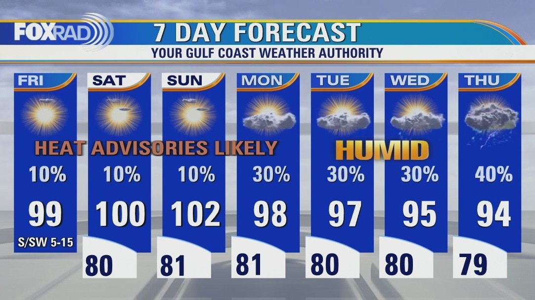
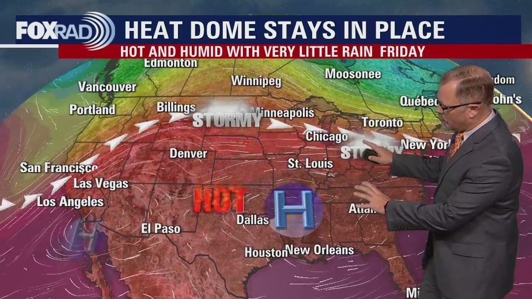
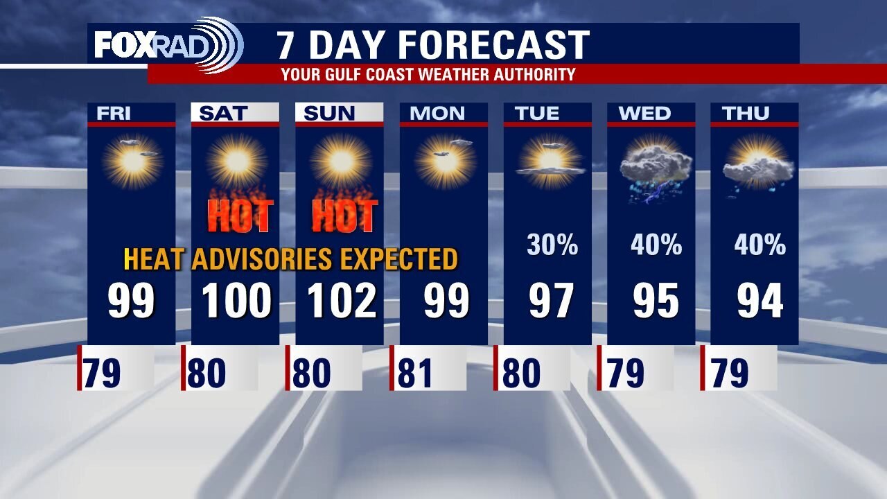
Sunny, sultry day Friday with highs in the upper 90s and feels like values 100+
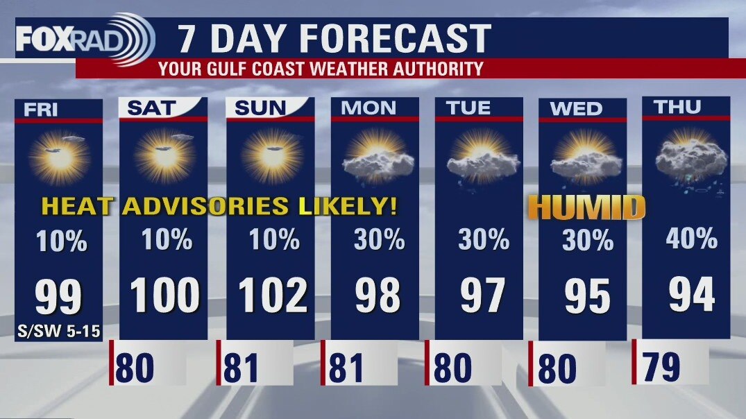
A very sultry end to the work week, as we brace ourselves for a dangerously hot weekend. May want to adjust those plans now, to avoid extended periods of time outdoors during peak hours. Heat Advisories are in place today north and west through 8 p.m., but will likely blanket the area through possibly Monday. Thankfully, a pattern change is in sight as this area of high pressure shifts and some disturbances look to reach us as early as possibly Monday, increasing rain chances and also providing a dip in temperatures.
A very sultry end to the work week, as we brace ourselves for a dangerously hot weekend. May want to adjust those plans now, to avoid extended periods of time outdoors during peak hours. Heat Advisories are in place today north and west through 8 p.m., but will likely blanket the area through possibly Monday. Thankfully, a pattern change is in sight as this area of high pressure shifts and some disturbances look to reach us as early as possibly Monday, increasing rain chances and also providing a dip in temperatures.
Friday morning weather forecast
HEAT ADVISORY has already been issued for some of Southeast Texas on Friday. More advisories will likely be needed for the weekend as the heat wave is expected to peak on Saturday and Sunday. Look for a slow change in the weather pattern as rain returns to the forecast can next week.
HEAT ADVISORY has already been issued for some of Southeast Texas on Friday. More advisories will likely be needed for the weekend as the heat wave is expected to peak on Saturday and Sunday. Look for a slow change in the weather pattern as rain returns to the forecast can next week.
Thursday evening weather forecast with Meteorologist John Dawson
HEAT ADVISORY has already been issued for some of Southeast Texas on Friday. More advisories will likely be needed for the weekend as the heat wave is expected to peak on Saturday and Sunday. Look for a slow change in the weather pattern as rain returns to the forecast can next week.
HEAT ADVISORY has already been issued for some of Southeast Texas on Friday. More advisories will likely be needed for the weekend as the heat wave is expected to peak on Saturday and Sunday. Look for a slow change in the weather pattern as rain returns to the forecast can next week.

Thursday afternoon weather forecast with Chief Meteorologist Mike Iscovitz
An isolated storm yesterday dropped about 1.5" of rain in east Houston, and we could have a few isolated storms again today. Overall though, the main concern continues to be an ongoing heat wave. Look for high temperatures to run in the upper 90s and low 100s areawide through this weekend. Next week, it appears a shift in the location of the "heat dome" could allow for showers and near normal temps.
An isolated storm yesterday dropped about 1.5" of rain in east Houston, and we could have a few isolated storms again today. Overall though, the main concern continues to be an ongoing heat wave. Look for high temperatures to run in the upper 90s and low 100s areawide through this weekend. Next week, it appears a shift in the location of the "heat dome" could allow for showers and near normal temps.
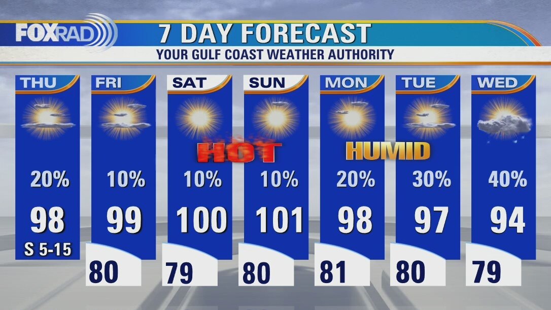
Mostly sunny, hot and humid Thursday with an isolated late day storm possible
An isolated storm yesterday dropped about 1.5" of rain in east Houston, and we could have a few isolated storms again today. Overall though, the main concern continues to be an ongoing heat wave. Look for high temperatures to run in the upper 90s and low 100s areawide through this weekend. Next week, it appears a shift in the location of the "heat dome" could allow for showers and near normal temps.
An isolated storm yesterday dropped about 1.5" of rain in east Houston, and we could have a few isolated storms again today. Overall though, the main concern continues to be an ongoing heat wave. Look for high temperatures to run in the upper 90s and low 100s areawide through this weekend. Next week, it appears a shift in the location of the "heat dome" could allow for showers and near normal temps.
Thursday morning weather forecast
More hot and humid days ahead for Houston as an area of high pressure builds back in over Southeast Texas. Rain chances decrease as we get closer to the weekend and triple digits should be here for Saturday and Sunday. Heat Advisories may also be needed. Be safe with all the weekend outdoors activities.
More hot and humid days ahead for Houston as an area of high pressure builds back in over Southeast Texas. Rain chances decrease as we get closer to the weekend and triple digits should be here for Saturday and Sunday. Heat Advisories may also be needed. Be safe with all the weekend outdoors activities.