

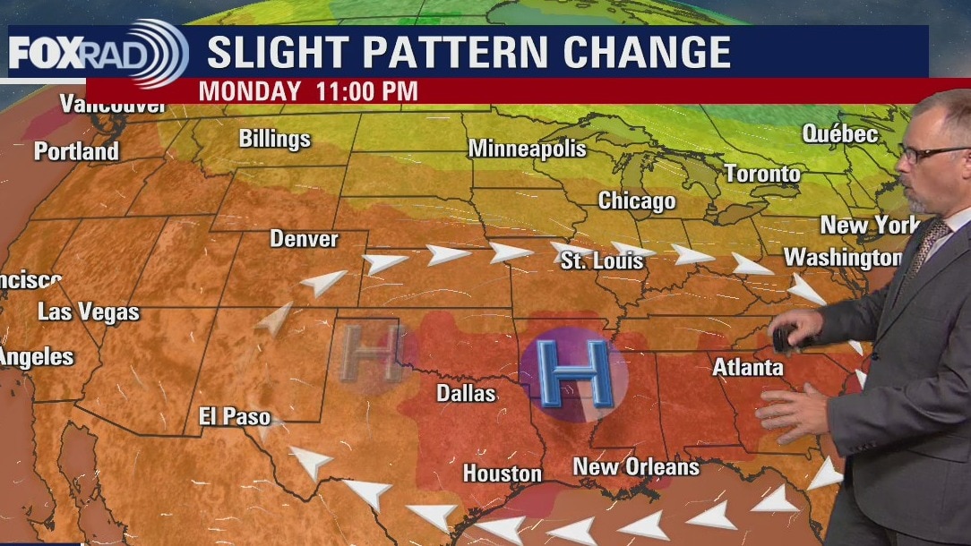
Monday evening weather forecast
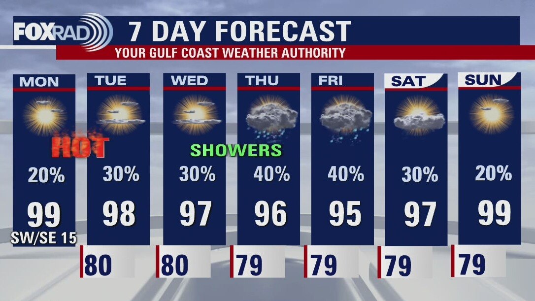
The afternoon high temperatures are expected to stay above normal for the start of the week, but we should see them return close to normal at the end of the week. Look for a few showers around each afternoon with slight higher chances on Thursday and Friday.
The afternoon high temperatures are expected to stay above normal for the start of the week, but we should see them return close to normal at the end of the week. Look for a few showers around each afternoon with slight higher chances on Thursday and Friday.
Soaring into the upper 90s Monday afternoon
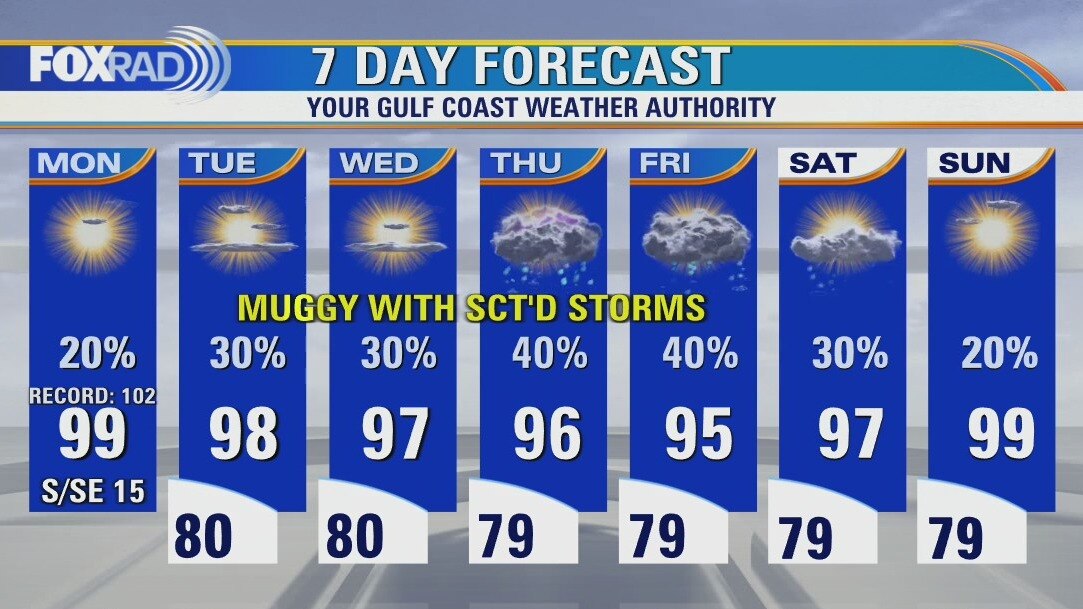
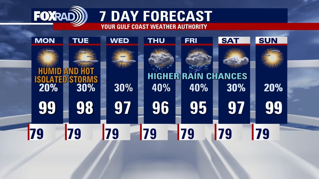
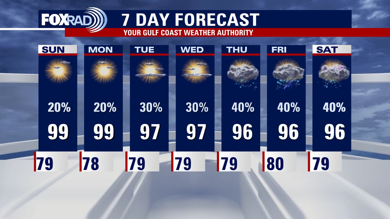
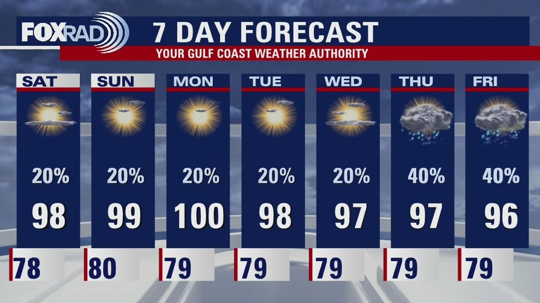
The outlook for this week gives us some optimism for helpful rain, but we'll very likely stay above normal for high and low temperatures regardless. Look for a hot and breezy start to the week with highs in the upper 90s and only isolated rain. Beginning Tuesday, rain chance look a bit higher and by Wednesday through Friday, scattered storms along with steamy temperatures are expected. The tropics remain quiet for now, but hurricane activity tends to increase dramatically through August and September.
The outlook for this week gives us some optimism for helpful rain, but we'll very likely stay above normal for high and low temperatures regardless. Look for a hot and breezy start to the week with highs in the upper 90s and only isolated rain. Beginning Tuesday, rain chance look a bit higher and by Wednesday through Friday, scattered storms along with steamy temperatures are expected. The tropics remain quiet for now, but hurricane activity tends to increase dramatically through August and September.
Mostly sunny and hot Monday with highs in the upper 90s
The outlook for this week gives us some optimism for helpful rain, but we'll very likely stay above normal for high and low temperatures regardless. Look for a hot and breezy start to the week with highs in the upper 90s and only isolated rain. Beginning Tuesday, rain chances look a bit higher and by Wednesday through Friday, scattered storms along with steamy temperatures are expected. The tropics remain quiet for now, but hurricane activity tends to increase dramatically through August and September.
The outlook for this week gives us some optimism for helpful rain, but we'll very likely stay above normal for high and low temperatures regardless. Look for a hot and breezy start to the week with highs in the upper 90s and only isolated rain. Beginning Tuesday, rain chances look a bit higher and by Wednesday through Friday, scattered storms along with steamy temperatures are expected. The tropics remain quiet for now, but hurricane activity tends to increase dramatically through August and September.
Sunday night leading into Monday morning weather forecast
The "normal" afternoon temperatures in Houston this time of year should top out at 95 degrees. Looks like Southeast Texas will be working towards that as we move through the week. We still need rain and the highest chances look to be towards the end of the week as well.
The "normal" afternoon temperatures in Houston this time of year should top out at 95 degrees. Looks like Southeast Texas will be working towards that as we move through the week. We still need rain and the highest chances look to be towards the end of the week as well.
Sunday Morning Forecast with Meteorologist Lena Maria
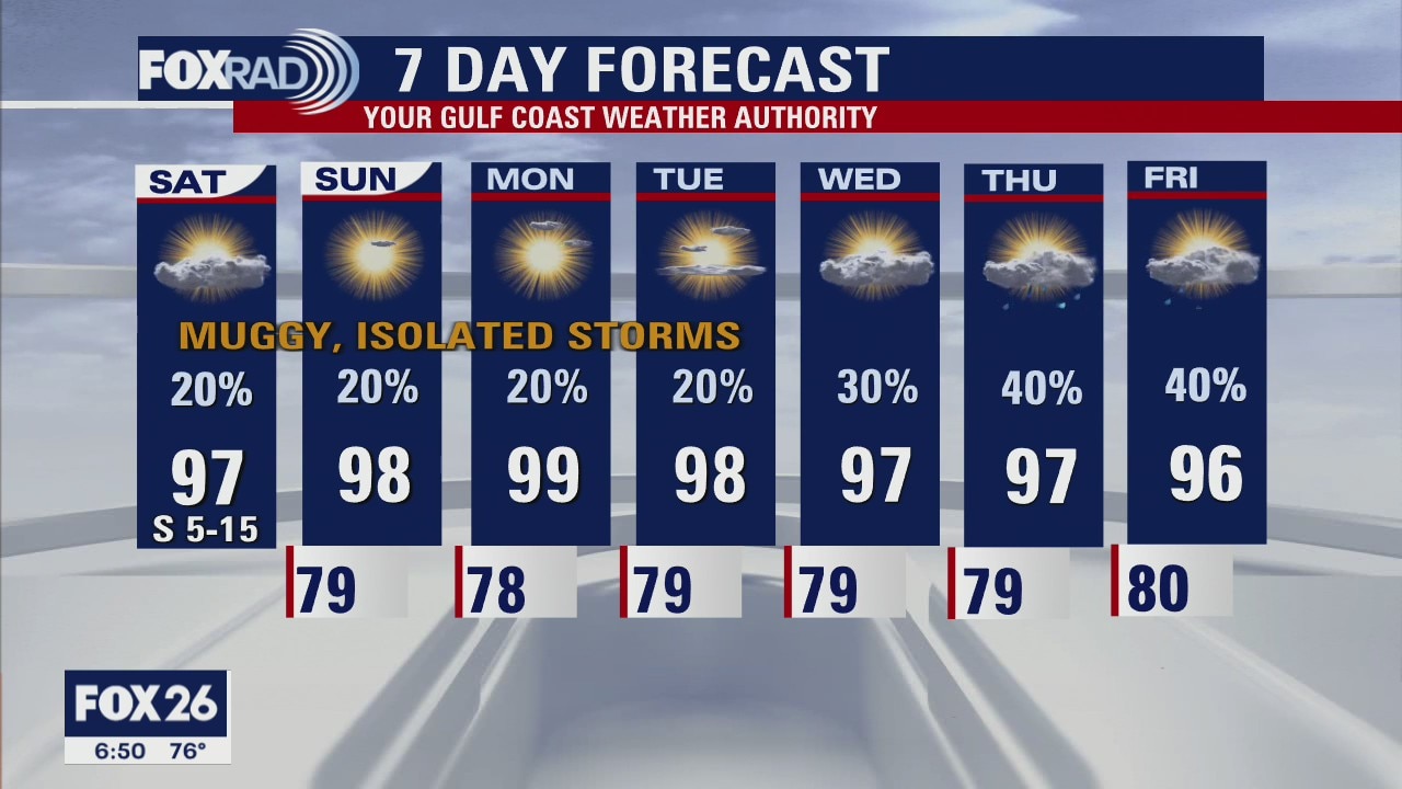
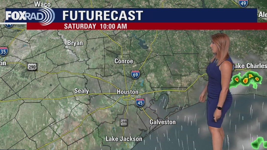
The weekend ends fairly identical to how it started, cooler with isolated rain chances. But the real "cool-down" comes toward the end of the week, when we could actually (dare I say it) see some normal daytime highs. That would end a nearly month long streak of above average temperatures. And its accompanied by better rain chances, as the heat dome shifts around a bit and a trough looks to undercut it. Fingers crossed, because another heat dome looks to build behind this somewhat unsettled stretch.
The weekend ends fairly identical to how it started, cooler with isolated rain chances. But the real "cool-down" comes toward the end of the week, when we could actually (dare I say it) see some normal daytime highs. That would end a nearly month long streak of above average temperatures. And its accompanied by better rain chances, as the heat dome shifts around a bit and a trough looks to undercut it. Fingers crossed, because another heat dome looks to build behind this somewhat unsettled stretch.
Saturday night leading into Sunday morning weather forecast
It's a copy-and-paste forecast for tomorrow! High heat and humidity continue with a few isolated thunderstorms possible. The activity again looks very hit or miss in variety so not everyone will see rain. A pattern change looks to arrive late next week, bringing more promising rain chances and seasonable temperatures are set to return.
It's a copy-and-paste forecast for tomorrow! High heat and humidity continue with a few isolated thunderstorms possible. The activity again looks very hit or miss in variety so not everyone will see rain. A pattern change looks to arrive late next week, bringing more promising rain chances and seasonable temperatures are set to return.
Saturday Morning Forecast with Meteorologist Lena Maria Arango
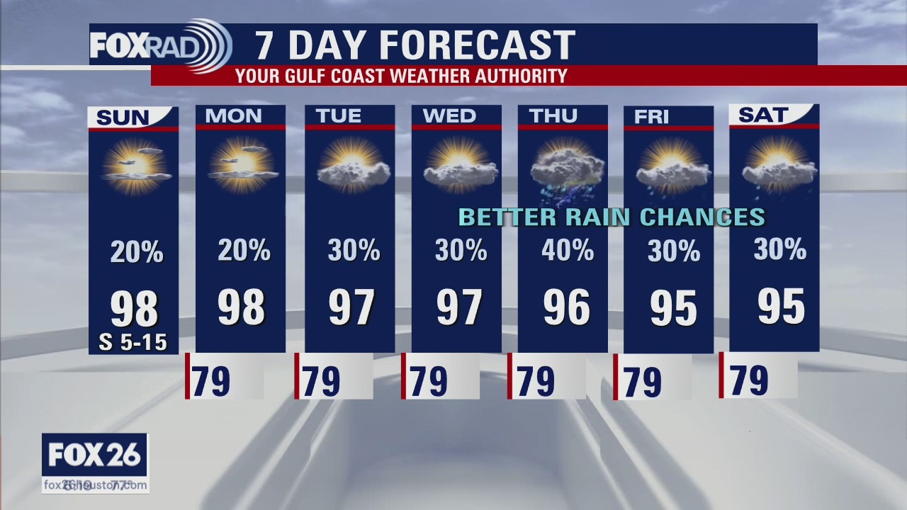
After spending most of the week in the triple digits, we'll take a bit of a break this weekend where most of us will top out in the 90s. Plan for a blend of sun and clouds, with humid but mostly dry conditions aside from an isolated precipitation. Not much changes at the start of next week, but as things begin to shift rain chances look to be a bit more promising mid-end of next week. Though heat indices look to be slightly below heat advisory criteria most days, heat safety should still be top of mind. The tropics remain quiet for now.
After spending most of the week in the triple digits, we'll take a bit of a break this weekend where most of us will top out in the 90s. Plan for a blend of sun and clouds, with humid but mostly dry conditions aside from an isolated precipitation. Not much changes at the start of next week, but as things begin to shift rain chances look to be a bit more promising mid-end of next week. Though heat indices look to be slightly below heat advisory criteria most days, heat safety should still be top of mind. The tropics remain quiet for now.
Saturday morning weather forecast
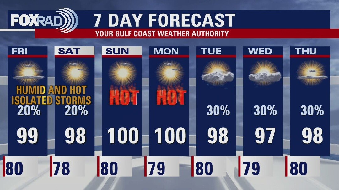
More heat and more humidity is on tap this weekend, with highs climbing into the upper 90s and feels like temperatures approaching 105. A few isolated storms are possible both Saturday and Sunday but the activity looks very hit or miss in variety. We continue with the hot weather pattern with daily isolated storm chances into early next week.
More heat and more humidity is on tap this weekend, with highs climbing into the upper 90s and feels like temperatures approaching 105. A few isolated storms are possible both Saturday and Sunday but the activity looks very hit or miss in variety. We continue with the hot weather pattern with daily isolated storm chances into early next week.
Friday evening weather forecast
More heat and more humidity is on tap this weekend, with highs climbing into the upper 90s and feels like temperatures approaching 105. A few isolated storms are possible both Saturday and Sunday but the activity looks very hit or miss in variety. We continue with the hot weather pattern with daily isolated storm chances into early next week.
More heat and more humidity is on tap this weekend, with highs climbing into the upper 90s and feels like temperatures approaching 105. A few isolated storms are possible both Saturday and Sunday but the activity looks very hit or miss in variety. We continue with the hot weather pattern with daily isolated storm chances into early next week.
Mostly sunny, hot and humid Friday with a few late day storms possible
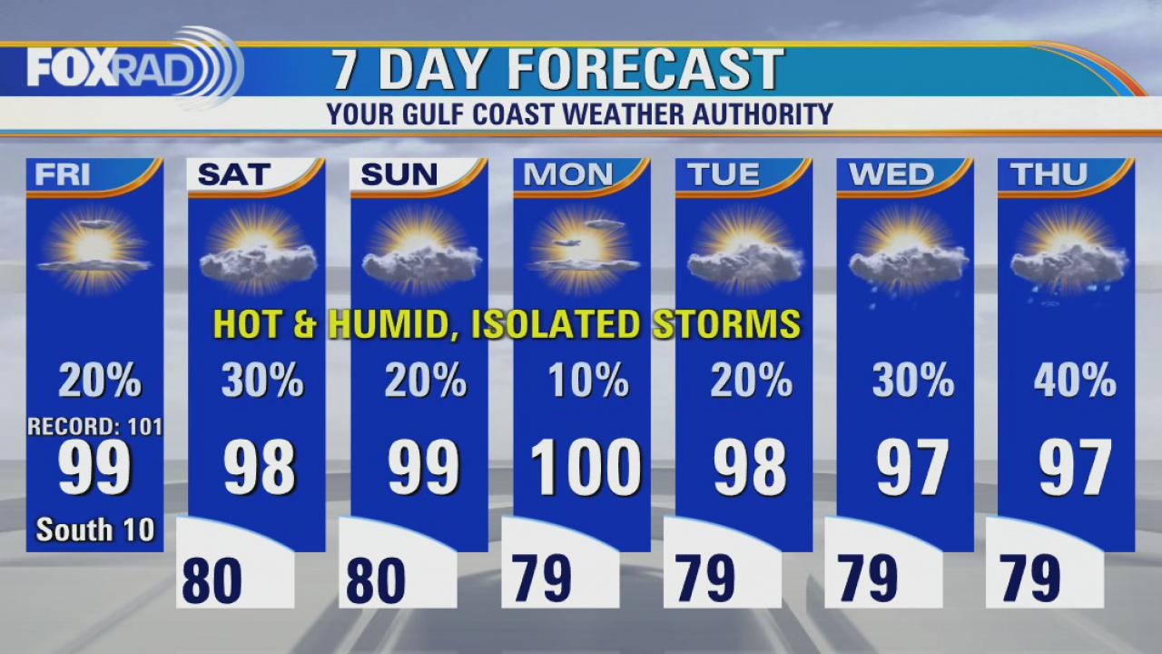
While our weather will remain very humid and hotter than normal for the next several days, there will be a decent chance for isolated storms each day. With the hit and miss nature of the expected downpours, there won't be much of an impact on the heat wave. We are on pace for the warmest July on record for both Houston and Galveston and there aren't any significant changes in sight.
While our weather will remain very humid and hotter than normal for the next several days, there will be a decent chance for isolated storms each day. With the hit and miss nature of the expected downpours, there won't be much of an impact on the heat wave. We are on pace for the warmest July on record for both Houston and Galveston and there aren't any significant changes in sight.
Friday morning weather forecast
The chances for rain are low but at least there are some chances for southeast Texas for the start of the weekend. The latest Drought Monitor has over 98% of Texas impacted by the lack of rain. Slightly higher chances for rain around Tuesday and Wednesday of next week.
The chances for rain are low but at least there are some chances for southeast Texas for the start of the weekend. The latest Drought Monitor has over 98% of Texas impacted by the lack of rain. Slightly higher chances for rain around Tuesday and Wednesday of next week.
Thursday evening weather forecast
The chances for rain are low but at least there are some chances for southeast Texas for the start of the weekend. The latest Drought Monitor has over 98% of Texas impacted by the lack of rain. Slightly higher chances for rain around Tuesday and Wednesday of next week.
The chances for rain are low but at least there are some chances for southeast Texas for the start of the weekend. The latest Drought Monitor has over 98% of Texas impacted by the lack of rain. Slightly higher chances for rain around Tuesday and Wednesday of next week.
Thursday morning weather forecast with Chief Meteorologist Mike Iscovitz
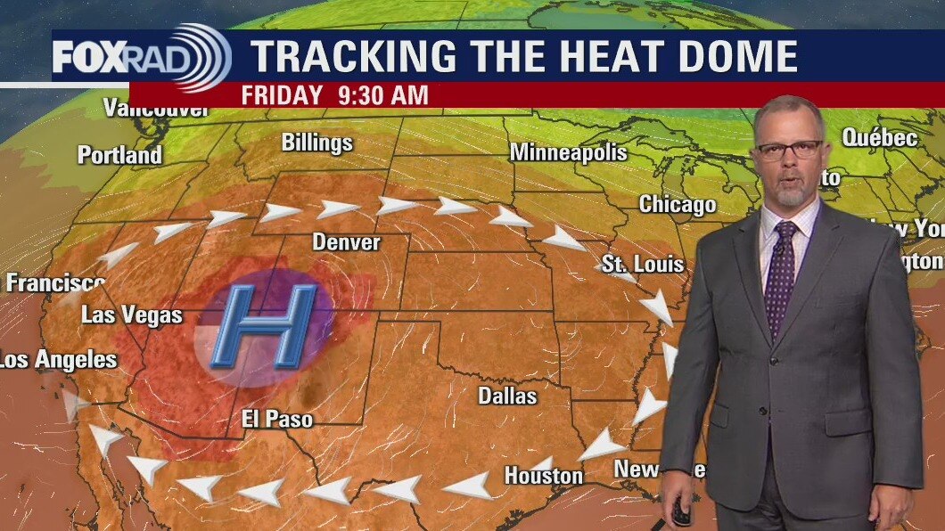
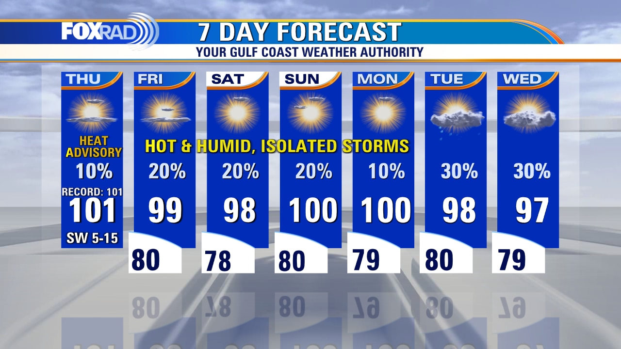
Once again a heat advisory is in effect areawide through 8 p.m. as highs will range from 95-105 today. Over the next few days, subtle changes in the location of the big ridge of high pressure, the so-called heat dome, could allow a few scattered late-day storms here, but don't expect much relief from the ongoing heat wave. The tropics remain quiet.
Once again a heat advisory is in effect areawide through 8 p.m. as highs will range from 95-105 today. Over the next few days, subtle changes in the location of the big ridge of high pressure, the so-called heat dome, could allow a few scattered late-day storms here, but don't expect much relief from the ongoing heat wave. The tropics remain quiet.
Thursday morning weather forecast
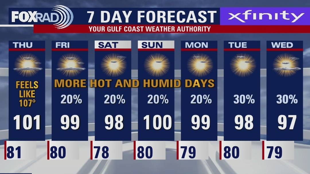
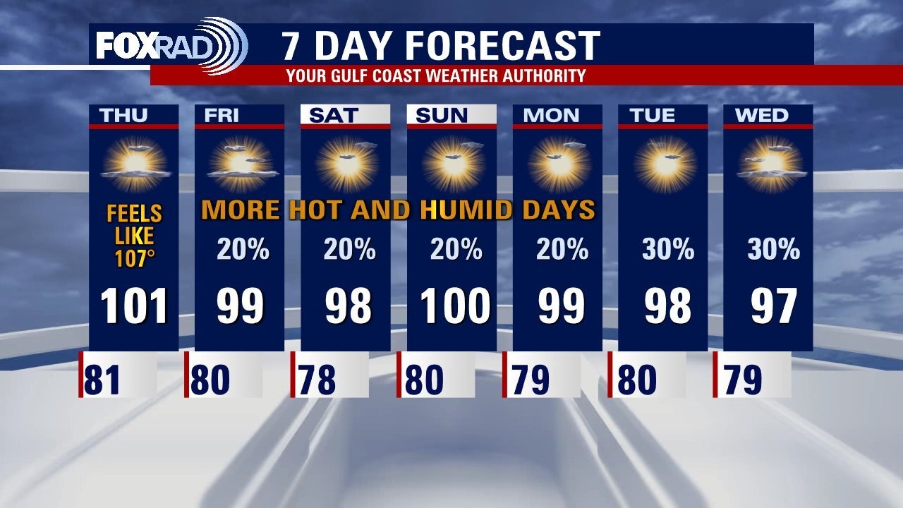
The heat wave continues for Southeast Texas but the peak for now has been reached. At this time, no heat advisories are expected for Thursday around the Houston area. It will still be very hot! But not enough heat for alerts to be issued by the National Weather Service. Isolated storms should return to the area on Friday and slightly higher rain chances for next week.
The heat wave continues for Southeast Texas but the peak for now has been reached. At this time, no heat advisories are expected for Thursday around the Houston area. It will still be very hot! But not enough heat for alerts to be issued by the National Weather Service. Isolated storms should return to the area on Friday and slightly higher rain chances for next week.
Wednesday evening weather forecast with Meteorologist John Dawson
The heat wave continues for Southeast Texas but the peak, for now, has been reached. At this time, no heat advisories are expected for Thursday around the Houston area. It will still be very hot! But not enough heat for alerts to be issued by the National Weather Service. Isolated storms should return to the area on Friday and have slightly higher rain chances for next week.
The heat wave continues for Southeast Texas but the peak, for now, has been reached. At this time, no heat advisories are expected for Thursday around the Houston area. It will still be very hot! But not enough heat for alerts to be issued by the National Weather Service. Isolated storms should return to the area on Friday and have slightly higher rain chances for next week.

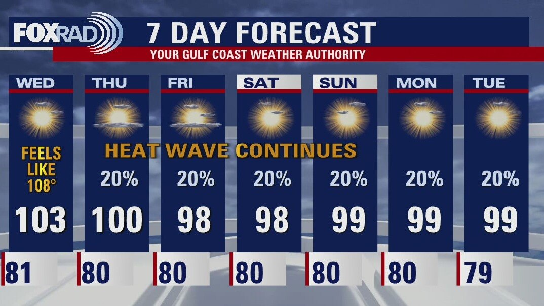
Wednesday afternoon weather forecast with Chief Meteorologist Mike Iscovitz
Houston has reached highs of 100 or higher 11 times this month and 16 times this year - we will likely add to those totals today. Look for a familiar weather day with sunshine, hot breezes and highs in the low 100s. There is a very small chance for rain today, but isolated late-day storms are more likely beginning Thursday through the weekend. Elevated fire risk continues for areas north and west of Houston, but burn bans are in effect for our entire area until further notice.
Houston has reached highs of 100 or higher 11 times this month and 16 times this year - we will likely add to those totals today. Look for a familiar weather day with sunshine, hot breezes and highs in the low 100s. There is a very small chance for rain today, but isolated late-day storms are more likely beginning Thursday through the weekend. Elevated fire risk continues for areas north and west of Houston, but burn bans are in effect for our entire area until further notice.
Mostly sunny, very hot Wednesday with highs in the low 100s
Houston has reached highs of 100 or higher 11 times this month and 16 times this year - we will likely add to those totals today. Look for a familiar weather day with sunshine, hot breezes and highs in the low 100s. There is a very small chance for rain today, but isolated late-day storms are more likely beginning Thursday through the weekend. Elevated fire risk continues for areas north and west of Houston, but burn bans are in effect for our entire area until further notice.
Houston has reached highs of 100 or higher 11 times this month and 16 times this year - we will likely add to those totals today. Look for a familiar weather day with sunshine, hot breezes and highs in the low 100s. There is a very small chance for rain today, but isolated late-day storms are more likely beginning Thursday through the weekend. Elevated fire risk continues for areas north and west of Houston, but burn bans are in effect for our entire area until further notice.
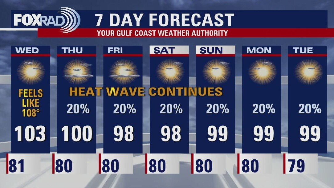
Wednesday morning weather forecast
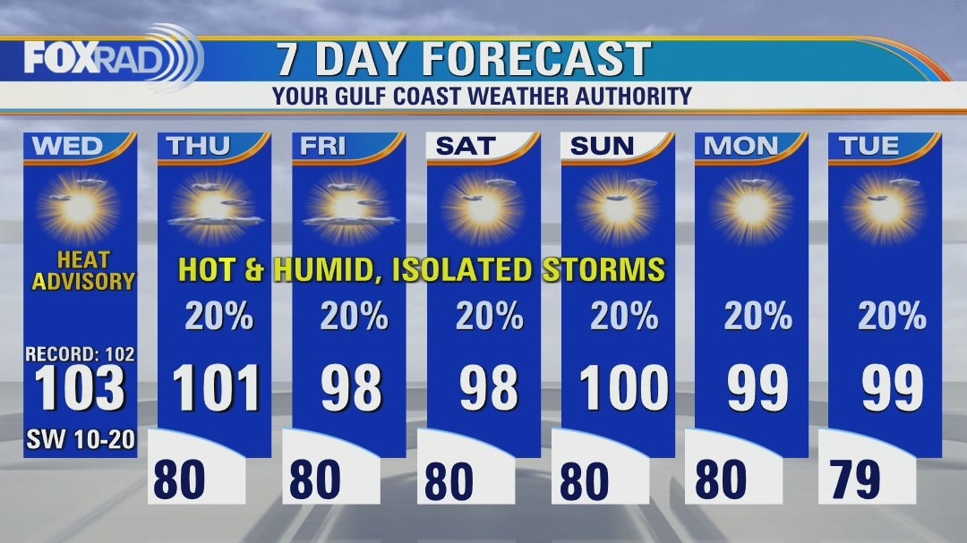
Extreme heat continues across Southeast Texas and should be around for several more days. The Northwest Counties in the FOX26 area will be under an Excessive Heat Warning for Wednesday and the rest of the area under a Heat Advisory. Use caution with any strenuous activities outdoors. There will be low chances for isolated rain as we move towards the end of the week.
Extreme heat continues across Southeast Texas and should be around for several more days. The Northwest Counties in the FOX26 area will be under an Excessive Heat Warning for Wednesday and the rest of the area under a Heat Advisory. Use caution with any strenuous activities outdoors. There will be low chances for isolated rain as we move towards the end of the week.
Tuesday evening weather forecast
Extreme heat continues across Southeast Texas and should be around for several more days. The Northwest Counties in the FOX26 area will be under an Excessive Heat Warning for Wednesday and the rest of the area under a Heat Advisory. Use caution with any strenuous activities outdoors. There will be low chances for isolated rain as we move toward the end of the week.
Extreme heat continues across Southeast Texas and should be around for several more days. The Northwest Counties in the FOX26 area will be under an Excessive Heat Warning for Wednesday and the rest of the area under a Heat Advisory. Use caution with any strenuous activities outdoors. There will be low chances for isolated rain as we move toward the end of the week.
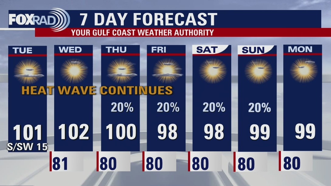
Hot, sultry Tuesday with highs near the 100s
Extreme heat continues across Texas again today and through the extended forecast along with a worsening drought and increasing threats for wildfires. All-time record heat has affected Europe including the warmest night on record in England - and they've been recording temperature records since the 1600s! Otherwise, locally, the forecast stays familiar with highs near 100 and heat advisories through at least Wednesday. A few showers are possible by the end of the week.
Extreme heat continues across Texas again today and through the extended forecast along with a worsening drought and increasing threats for wildfires. All-time record heat has affected Europe including the warmest night on record in England - and they've been recording temperature records since the 1600s! Otherwise, locally, the forecast stays familiar with highs near 100 and heat advisories through at least Wednesday. A few showers are possible by the end of the week.