

Saturday Morning Forecast with Meteorologist Lena Maria
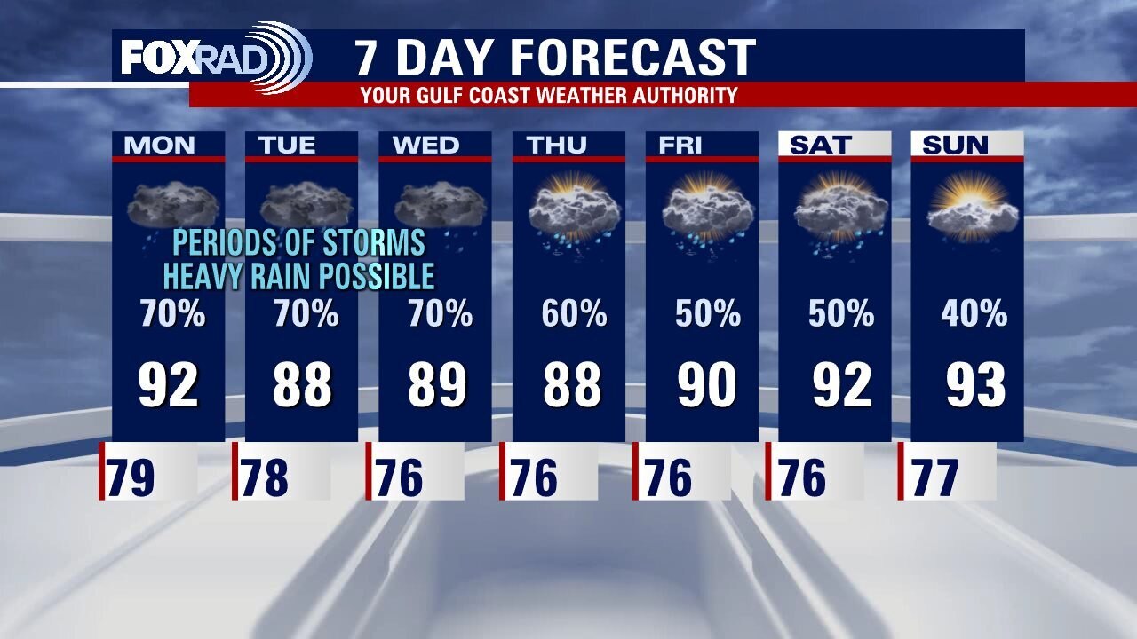
Daily rounds of showers and storms, which may be heavy at times remain in the forecast over the course of the next week. In addition to unsettled weather, which will continue to bring improvements to the drought we will also be cashing in on seasonably cool temperatures. Keeping a close eye on the tropics as the peak of Hurricane Season approaches, but there are no local causes for concern in the immediate future.
Daily rounds of showers and storms, which may be heavy at times remain in the forecast over the course of the next week. In addition to unsettled weather, which will continue to bring improvements to the drought we will also be cashing in on seasonably cool temperatures. Keeping a close eye on the tropics as the peak of Hurricane Season approaches, but there are no local causes for concern in the immediate future.
Saturday morning weather forecast
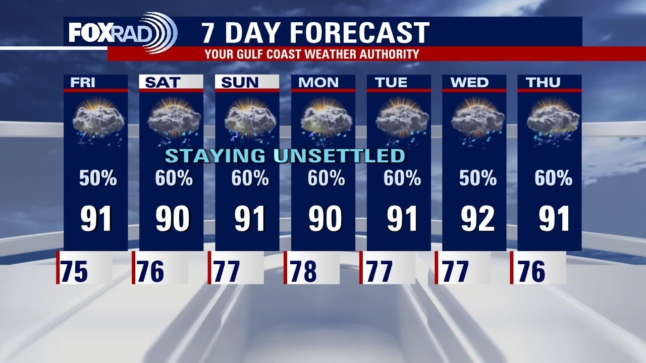
More drought relief is ahead as our unsettled pattern continues this weekend. Scattered rain and storms will be around both Saturday and Sunday, with localized flooding possible. With the added rain and clouds, temperatures will stay below normal. Highs through much of next week will just climb into the upper 80s and low 90s.
More drought relief is ahead as our unsettled pattern continues this weekend. Scattered rain and storms will be around both Saturday and Sunday, with localized flooding possible. With the added rain and clouds, temperatures will stay below normal. Highs through much of next week will just climb into the upper 80s and low 90s.

Friday evening weather forecast with Meteorologist Adrienne Vonn
More drought relief is ahead as our unsettled pattern continues this weekend. Scattered rain and storms will be around both Saturday and Sunday, with localized flooding possible. With the added rain and clouds, temperatures will stay below normal. Highs through much of next week will just climb into the upper 80s and low 90s.
More drought relief is ahead as our unsettled pattern continues this weekend. Scattered rain and storms will be around both Saturday and Sunday, with localized flooding possible. With the added rain and clouds, temperatures will stay below normal. Highs through much of next week will just climb into the upper 80s and low 90s.
Mostly cloudy and muggy with scattered storms mostly in the afternoon
We are still in the midst of a moist, unsettled weather pattern that should stay with us through next week. Each day brings a good chance for mainly afternoon storms and coastal showers each morning. Some heavier rain looks likely early next week. In the longer term, we will closely monitor the progress of a tropical wave as it moves through the Caribbean. The American GFS model has been consistently showing it strengthening in about 7 days while the Euro model shows nothing. It bears watching, so we'll keep you informed.
We are still in the midst of a moist, unsettled weather pattern that should stay with us through next week. Each day brings a good chance for mainly afternoon storms and coastal showers each morning. Some heavier rain looks likely early next week. In the longer term, we will closely monitor the progress of a tropical wave as it moves through the Caribbean. The American GFS model has been consistently showing it strengthening in about 7 days while the Euro model shows nothing. It bears watching, so we'll keep you informed.
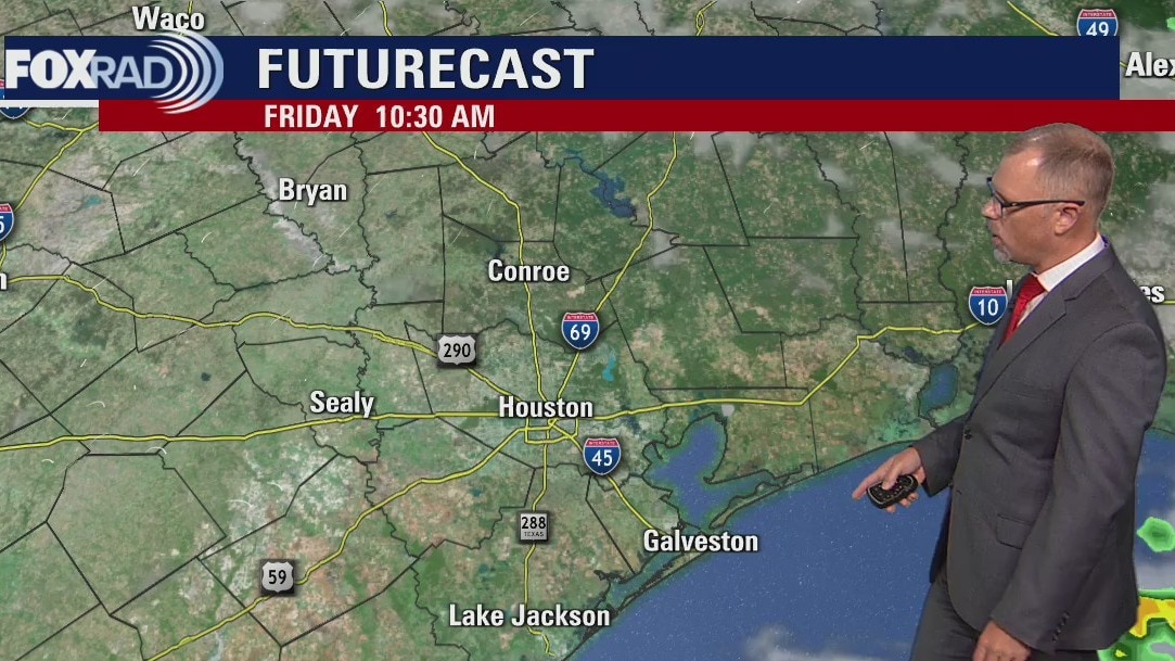
Friday morning weather forecast
Rain remains in the forecast over the course of the extended period, which will lead to continued improvements to the drought. And as we reflect on the anniversaries of major impactful storms such as Hurricanes Harvey and Andrew, thankfully the tropics remain quiet at this time. A few waves are being monitored by the NHC, with low chances for gradual development.
Rain remains in the forecast over the course of the extended period, which will lead to continued improvements to the drought. And as we reflect on the anniversaries of major impactful storms such as Hurricanes Harvey and Andrew, thankfully the tropics remain quiet at this time. A few waves are being monitored by the NHC, with low chances for gradual development.
Thursday evening weather forecast with Meteorologist John Dawson
Rain remains in the forecast over the course of the extended period, which will lead to continued improvements to the drought. And as we reflect on the anniversaries of major impactful storms such as Hurricanes Harvey and Andrew, thankfully the tropics remain quiet at this time. A few waves are being monitored by the NHC, with low chances for gradual development.
Rain remains in the forecast over the course of the extended period, which will lead to continued improvements to the drought. And as we reflect on the anniversaries of major impactful storms such as Hurricanes Harvey and Andrew, thankfully the tropics remain quiet at this time. A few waves are being monitored by the NHC, with low chances for gradual development.
Thursday afternoon weather forecast with Meteorologist Lena Maria Arango
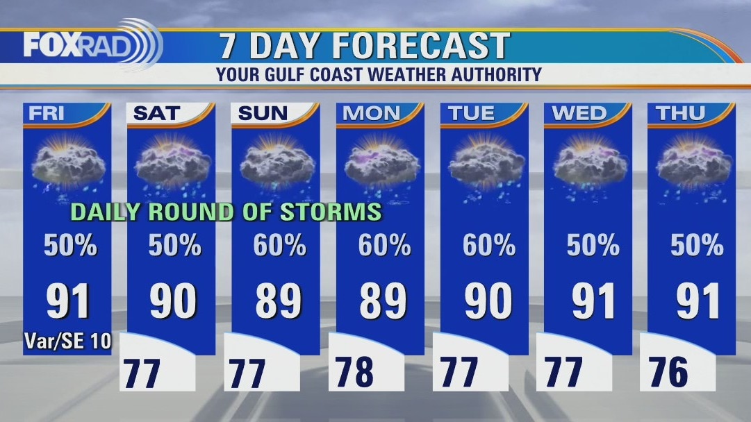
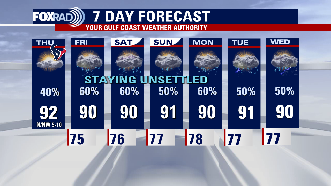
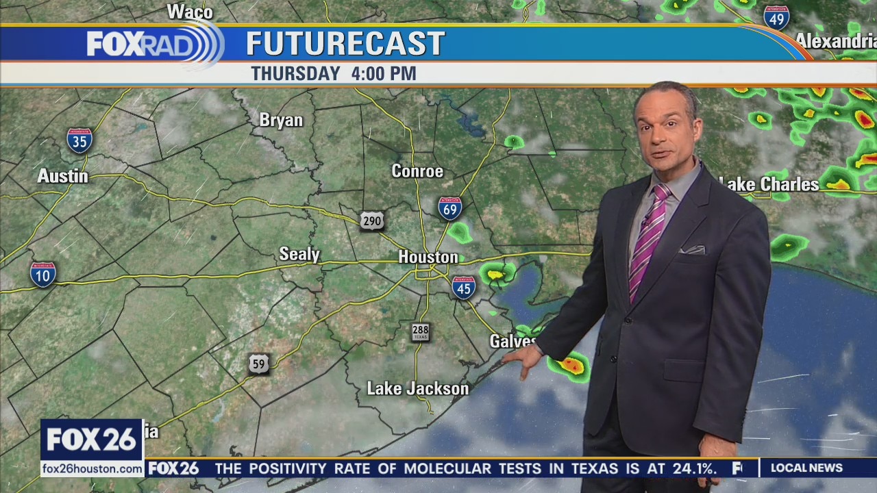
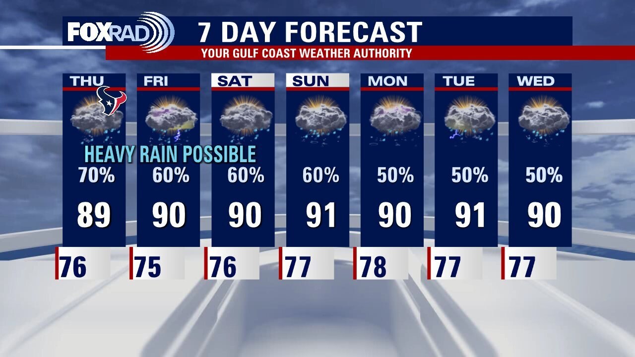
Plan for a warm and humid day, with partly cloudy skies and isolated to scattered showers and storms through sunset. You'll want to stay weather aware if you're tailgating for the Texans, though we look to dry out by kickoff. Rain does remain in the forecast over the course of the extended period, which will lead to continued improvements to the drought. And as we reflect on the anniversaries of major impactful storms such as Hurricanes Harvey and Andrew, thankfully the tropics remain quiet at this time. A few waves are being monitored by the NHC, with low chances for gradual development.
Plan for a warm and humid day, with partly cloudy skies and isolated to scattered showers and storms through sunset. You'll want to stay weather aware if you're tailgating for the Texans, though we look to dry out by kickoff. Rain does remain in the forecast over the course of the extended period, which will lead to continued improvements to the drought. And as we reflect on the anniversaries of major impactful storms such as Hurricanes Harvey and Andrew, thankfully the tropics remain quiet at this time. A few waves are being monitored by the NHC, with low chances for gradual development.
Rain along the coast on 5 year mark since Hurricane Harvey landfall
On this 5th anniversary of Hurricane Harvey's landfall, many areas should get a break from downpours, however, very heavy rain may impact Matagorda, Jackson, and coastal Brazoria Counties. The rest of the outlook for the end of this week and much of next week looks to remain unsettled with gulf moisture leading to a daily round of storms. In the tropics, there are no immediate concerns, but activity could ramp up by the first week of September.
On this 5th anniversary of Hurricane Harvey's landfall, many areas should get a break from downpours, however, very heavy rain may impact Matagorda, Jackson, and coastal Brazoria Counties. The rest of the outlook for the end of this week and much of next week looks to remain unsettled with gulf moisture leading to a daily round of storms. In the tropics, there are no immediate concerns, but activity could ramp up by the first week of September.
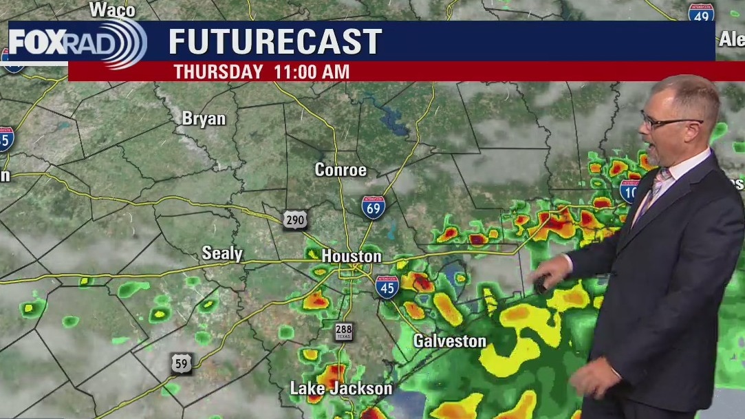
Thursday morning weather forecast
Scattered downpours remain a concern for southeast Texas over the next several days. Some of those heavy rains could cause street flooding and could happen any time during the day or night. Be careful driving in the dark! The rainy pattern sticks around for Houston all the way through the 7 day period. Temperatures look to stay mostly near/below normal with increased cloud cover and rain chances.
Scattered downpours remain a concern for southeast Texas over the next several days. Some of those heavy rains could cause street flooding and could happen any time during the day or night. Be careful driving in the dark! The rainy pattern sticks around for Houston all the way through the 7 day period. Temperatures look to stay mostly near/below normal with increased cloud cover and rain chances.
Wednesday evening weather forecast with Meteorologist John Dawson
Scattered downpours remain a concern for southeast Texas over the next several days. Some of those heavy rains could cause street flooding and could happen any time during the day or night. Be careful driving in the dark! The rainy pattern sticks around for Houston all the way through the 7 day period. Temperatures look to stay mostly near/below normal with increased cloud cover and rain chances.
Scattered downpours remain a concern for southeast Texas over the next several days. Some of those heavy rains could cause street flooding and could happen any time during the day or night. Be careful driving in the dark! The rainy pattern sticks around for Houston all the way through the 7 day period. Temperatures look to stay mostly near/below normal with increased cloud cover and rain chances.
Scattered showers and storms throughout the day
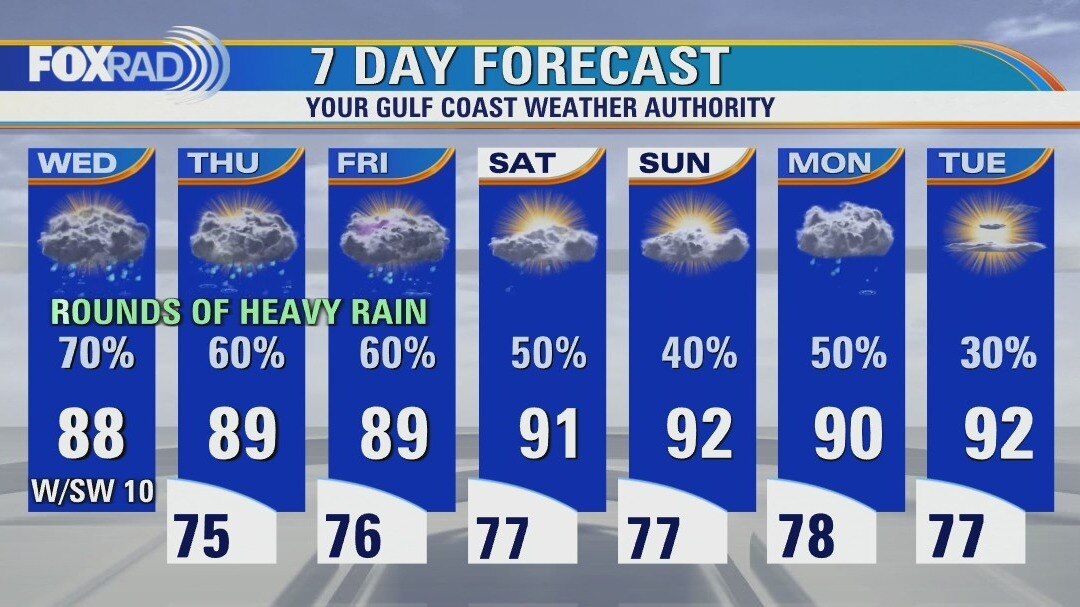
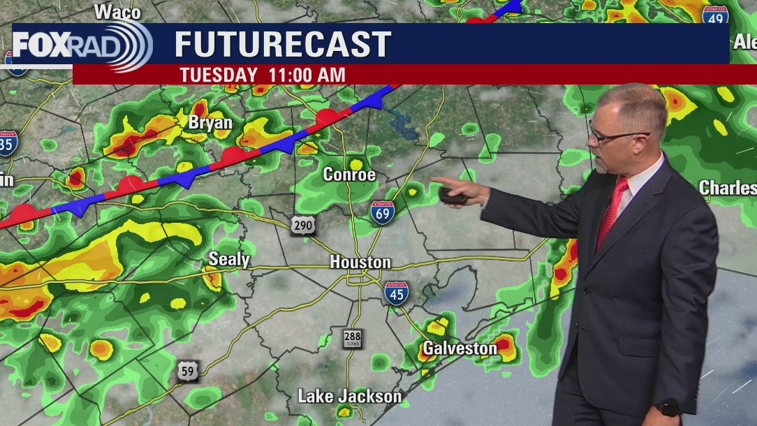
Be on the lookout for a few rounds of heavy rain over the next few days. Today, a scattering of downpours is expected with some dropping more than 2" of rain. Depending on location, some street flooding will be possible. Conditions look favorable for isolated heavy storms for tomorrow and Friday as well. Our overall pattern is likely to stay on the wet side for the next couple of weeks. The tropics remain remarkably quiet for now, but activity could pick up at the end of the month and into early September.
Be on the lookout for a few rounds of heavy rain over the next few days. Today, a scattering of downpours is expected with some dropping more than 2" of rain. Depending on location, some street flooding will be possible. Conditions look favorable for isolated heavy storms for tomorrow and Friday as well. Our overall pattern is likely to stay on the wet side for the next couple of weeks. The tropics remain remarkably quiet for now, but activity could pick up at the end of the month and into early September.
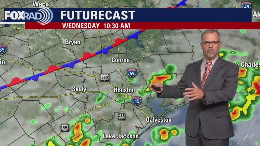
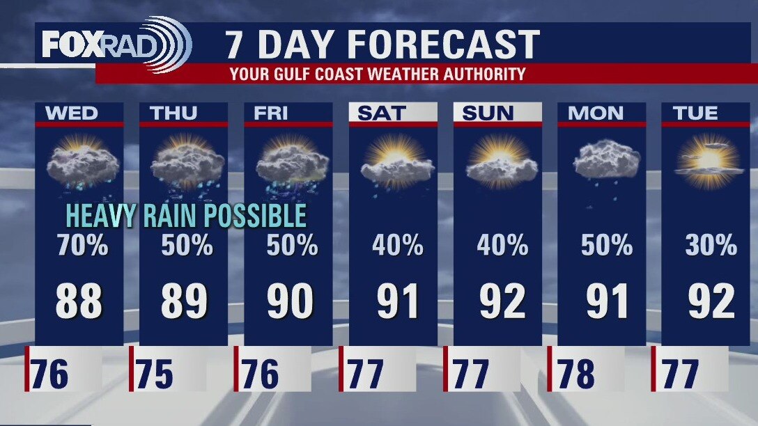
Wednesday morning weather forecast
The widespread flood risk has diminished some for southeast Texas but an unsettled pattern remains. Possible heavy downpours could still lead to some isolated street flooding for parts of Houston. Look for the afternoon highs to stick in the upper 80s for the next couple of days and then return to the lower 90s for the weekend.
The widespread flood risk has diminished some for southeast Texas but an unsettled pattern remains. Possible heavy downpours could still lead to some isolated street flooding for parts of Houston. Look for the afternoon highs to stick in the upper 80s for the next couple of days and then return to the lower 90s for the weekend.
Tuesday evening weather forecast
The widespread flood risk has diminished some for southeast Texas but an unsettled pattern remains. Possible heavy downpours could still lead to some isolated street flooding for parts of Houston. Look for the afternoon highs to stick in the upper 80s for the next couple of days and then return to the lower 90s for the weekend.
The widespread flood risk has diminished some for southeast Texas but an unsettled pattern remains. Possible heavy downpours could still lead to some isolated street flooding for parts of Houston. Look for the afternoon highs to stick in the upper 80s for the next couple of days and then return to the lower 90s for the weekend.
Rounds of heavy rain with warm, humid weather in between
Up to 4" of rain fell in parts of Montgomery County early this morning and, after a lull in activity, we will most likely see storms redevelop this afternoon. Watch for some downpours that could drop a quick 2-3" of rain. A high probability for rain will remain in place through the end of the week. Rainy weather has certainly put a dent in our drought, but also comes with the daily threat for isolated heavy rain.
Up to 4" of rain fell in parts of Montgomery County early this morning and, after a lull in activity, we will most likely see storms redevelop this afternoon. Watch for some downpours that could drop a quick 2-3" of rain. A high probability for rain will remain in place through the end of the week. Rainy weather has certainly put a dent in our drought, but also comes with the daily threat for isolated heavy rain.
Tuesday morning weather forecast
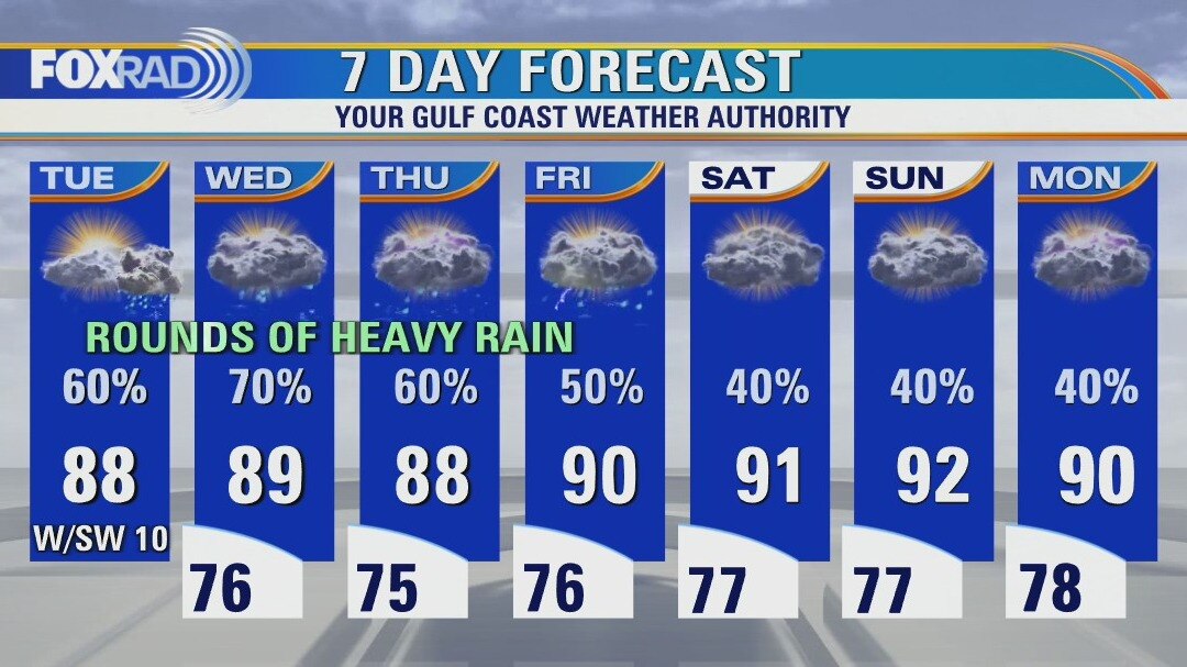
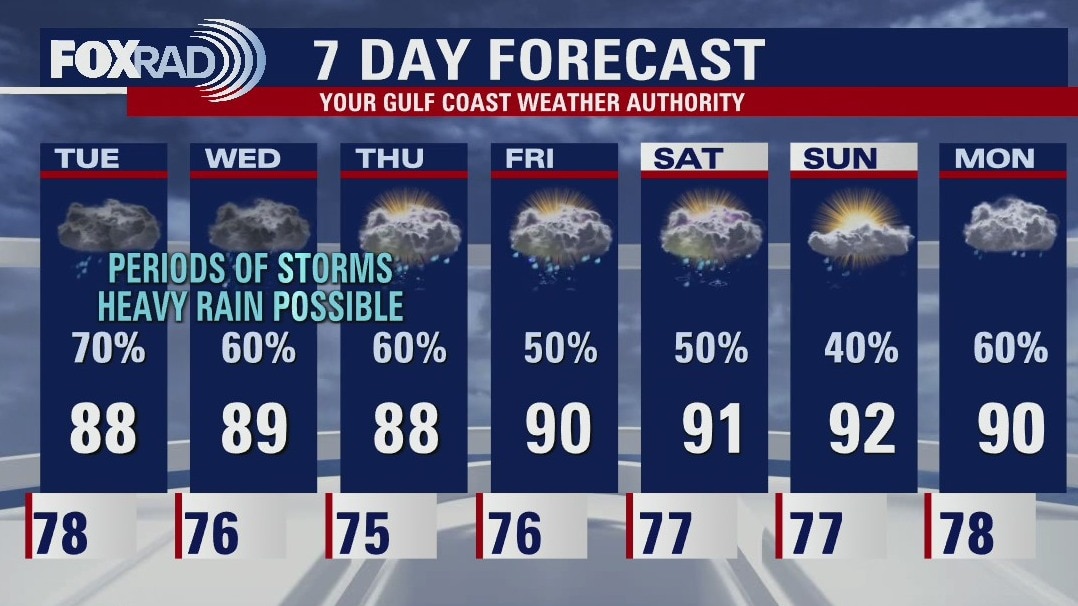
Parts of the FOX26 area are under a Flood Watch until Tuesday evening. Be ready for some heavy downpours and stormy weather at times across Southeast Texas for the next several days. With the extra clouds and chances for rain the afternoon high temperatures will be below the expected end of August averages in the mid 90s. Stay connected with the FOX26 Weather App over the next few days!
Parts of the FOX26 area are under a Flood Watch until Tuesday evening. Be ready for some heavy downpours and stormy weather at times across Southeast Texas for the next several days. With the extra clouds and chances for rain the afternoon high temperatures will be below the expected end of August averages in the mid 90s. Stay connected with the FOX26 Weather App over the next few days!
Monday evening weather forecast
Parts of the FOX26 area are under a Flood Watch until Tuesday evening. Be ready for some heavy downpours and stormy weather at times across Southeast Texas for the next several days. With the extra clouds and chances for rain the afternoon high temperatures will be below the expected end of August averages in the mid 90s. Stay connected with the FOX26 Weather App over the next few days!
Parts of the FOX26 area are under a Flood Watch until Tuesday evening. Be ready for some heavy downpours and stormy weather at times across Southeast Texas for the next several days. With the extra clouds and chances for rain the afternoon high temperatures will be below the expected end of August averages in the mid 90s. Stay connected with the FOX26 Weather App over the next few days!
Steamy Monday morning with isolated showers; scattered afternoon storms
I really hope kids don't have 1st period PE, because it is extremely muggy this morning and we have a hot, humid day ahead. Scattered late day and evening storms are expected, especially north and west of Houston. Rain looks more likely from tonight through Tuesday, Wednesday and Thursday (at least). Any individual storm could be heavy and produce several inches of rain. Dallas was hit by 7" of rain just this morning causing serious flooding, so we need to be on guard as well, especially beginning tomorrow.
I really hope kids don't have 1st period PE, because it is extremely muggy this morning and we have a hot, humid day ahead. Scattered late day and evening storms are expected, especially north and west of Houston. Rain looks more likely from tonight through Tuesday, Wednesday and Thursday (at least). Any individual storm could be heavy and produce several inches of rain. Dallas was hit by 7" of rain just this morning causing serious flooding, so we need to be on guard as well, especially beginning tomorrow.
Sunday night leading into Monday morning weather forecast
The week starts soggy with some isolated heavy downpours causing a few problems. With the increased rain chances come cooler temperatures, plus the drought relief continues and a major dent is expected in this week's update. Be ready for slower traveling around town this week will all the rain, drive safe in the rain!
The week starts soggy with some isolated heavy downpours causing a few problems. With the increased rain chances come cooler temperatures, plus the drought relief continues and a major dent is expected in this week's update. Be ready for slower traveling around town this week will all the rain, drive safe in the rain!

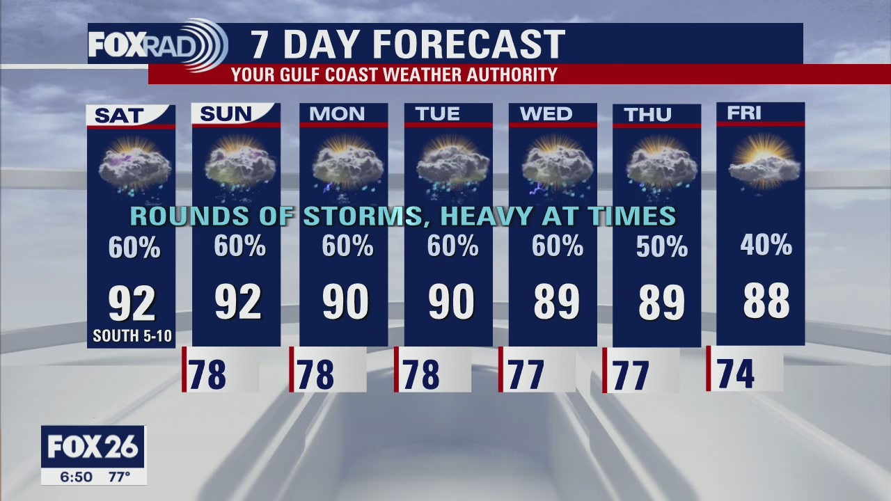
Sunday Morning Forecast with Meteorologist Lena Maria Arango
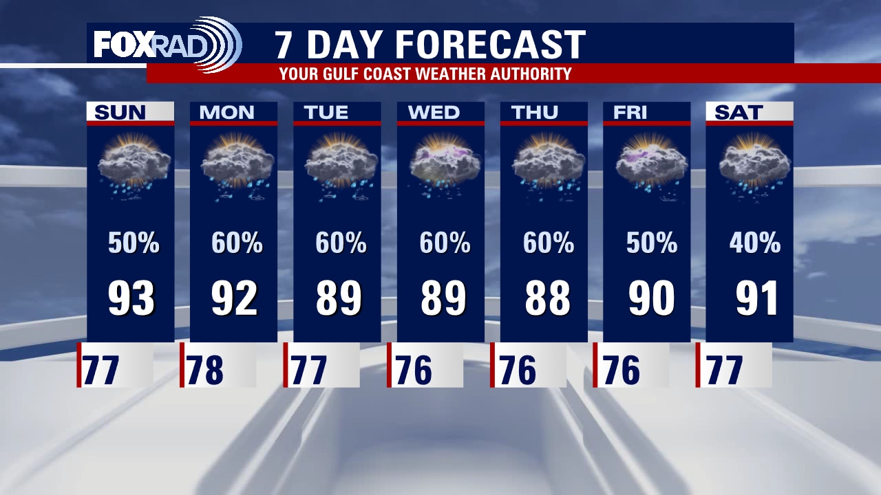
We are in for a soggy week, start to finish and things could get dicey from time to time with locally heavy rainfall. Pack your patience on the roadways, and allow for extra time throughout the week. On the plus side, the drought relief continues and a major dent is expected come Thursday's update. Daytime highs will also be well below average for the entire week, but overnights will be warm and humid.
We are in for a soggy week, start to finish and things could get dicey from time to time with locally heavy rainfall. Pack your patience on the roadways, and allow for extra time throughout the week. On the plus side, the drought relief continues and a major dent is expected come Thursday's update. Daytime highs will also be well below average for the entire week, but overnights will be warm and humid.
Saturday night leading into Sunday morning weather forecast
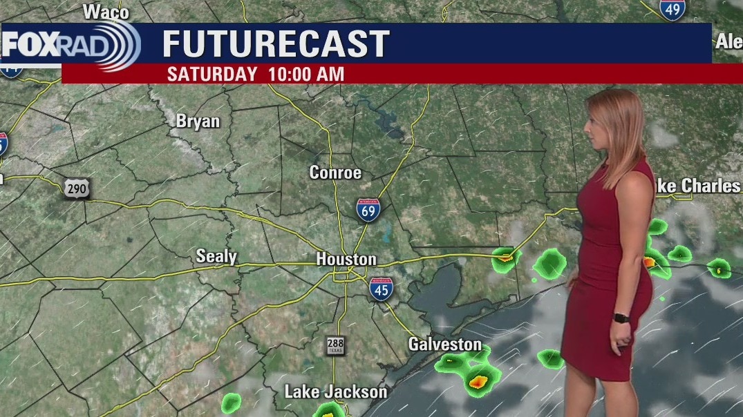
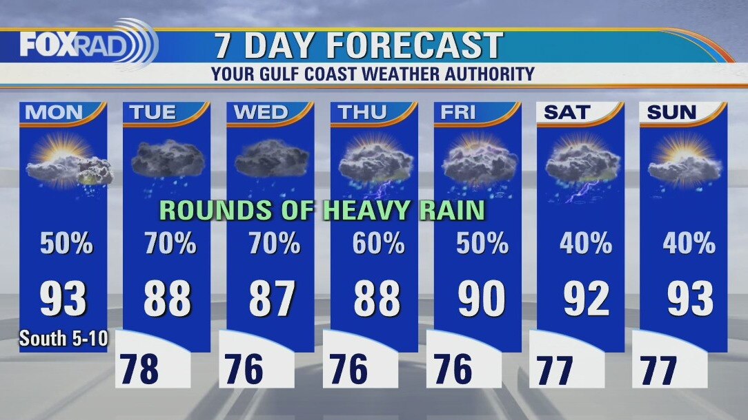
Grab the umbrellas! A slow-moving boundary is set to bring several opportunities for rain and thunderstorms as we head into next week. Some of the rain could be heavy at times and localized flooding will be possible. Not only will the rain help with ongoing drought conditions across the area, but it'll also help keep our temperatures down. Highs will largely be in the upper 80s and low 90s through the next several days.
Grab the umbrellas! A slow-moving boundary is set to bring several opportunities for rain and thunderstorms as we head into next week. Some of the rain could be heavy at times and localized flooding will be possible. Not only will the rain help with ongoing drought conditions across the area, but it'll also help keep our temperatures down. Highs will largely be in the upper 80s and low 90s through the next several days.