

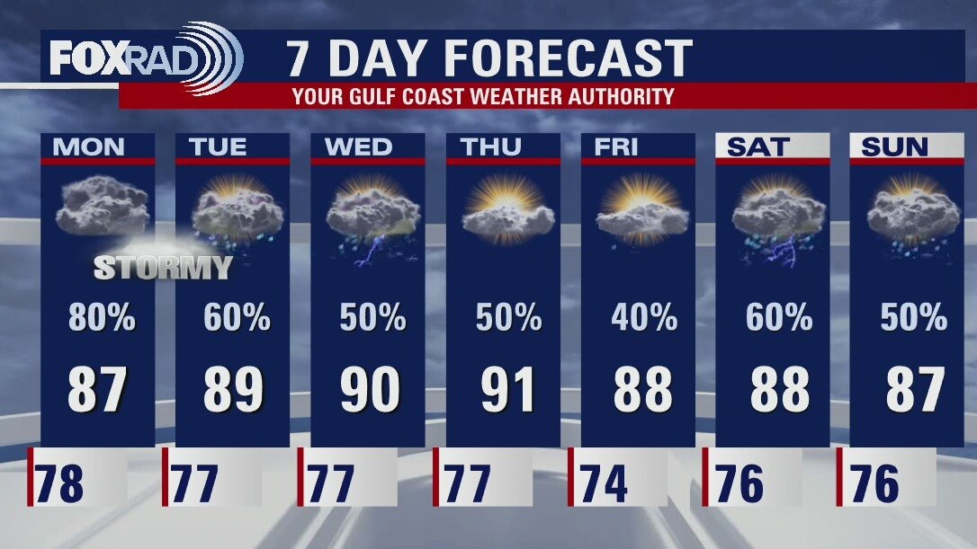
Rainy Labor Day weekend ahead
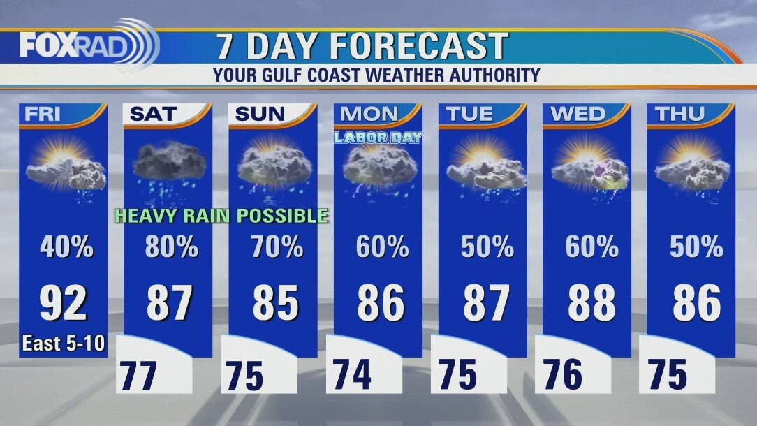
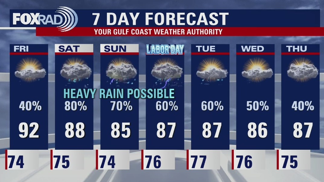
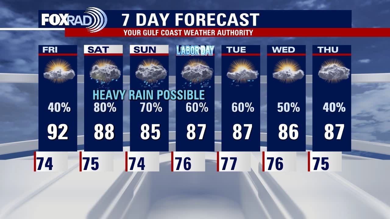
The combination of abundant Gulf moisture, a weak stationary front and a series of disturbances in the jet stream will combine to give us a rainy weather pattern for Labor Day weekend. Some heavy rain will be possible each day, but rain will likely come through in waves with cloudy and humid conditions in between. A widespread 2-3" should blanket the area through the 3-day weekend while isolated areas could easily get several inches in a day, it's just too random to point out any specific area, so make sure to check the FOX 26 weather app.
The combination of abundant Gulf moisture, a weak stationary front and a series of disturbances in the jet stream will combine to give us a rainy weather pattern for Labor Day weekend. Some heavy rain will be possible each day, but rain will likely come through in waves with cloudy and humid conditions in between. A widespread 2-3" should blanket the area through the 3-day weekend while isolated areas could easily get several inches in a day, it's just too random to point out any specific area, so make sure to check the FOX 26 weather app.
Partly cloudy & humid start Friday, with scattered PM storm
Today will be pretty similar to yesterday, with isolated afternoon storms. Conditions look to deteriorate over the long holiday weekend, with a higher probability of downpours on Saturday and Sunday. Definitely be sure to have a plan B for local outdoor plans, and factor in extra time for possible travel delays if headed out of town. Our cooler, rainy pattern doesn't look to let up anytime soon. And, though the Tropics are more active as we approach the peak of the season no system is of threat to the Continental U.S. at this time.
Today will be pretty similar to yesterday, with isolated afternoon storms. Conditions look to deteriorate over the long holiday weekend, with a higher probability of downpours on Saturday and Sunday. Definitely be sure to have a plan B for local outdoor plans, and factor in extra time for possible travel delays if headed out of town. Our cooler, rainy pattern doesn't look to let up anytime soon. And, though the Tropics are more active as we approach the peak of the season no system is of threat to the Continental U.S. at this time.
Friday morning weather forecast
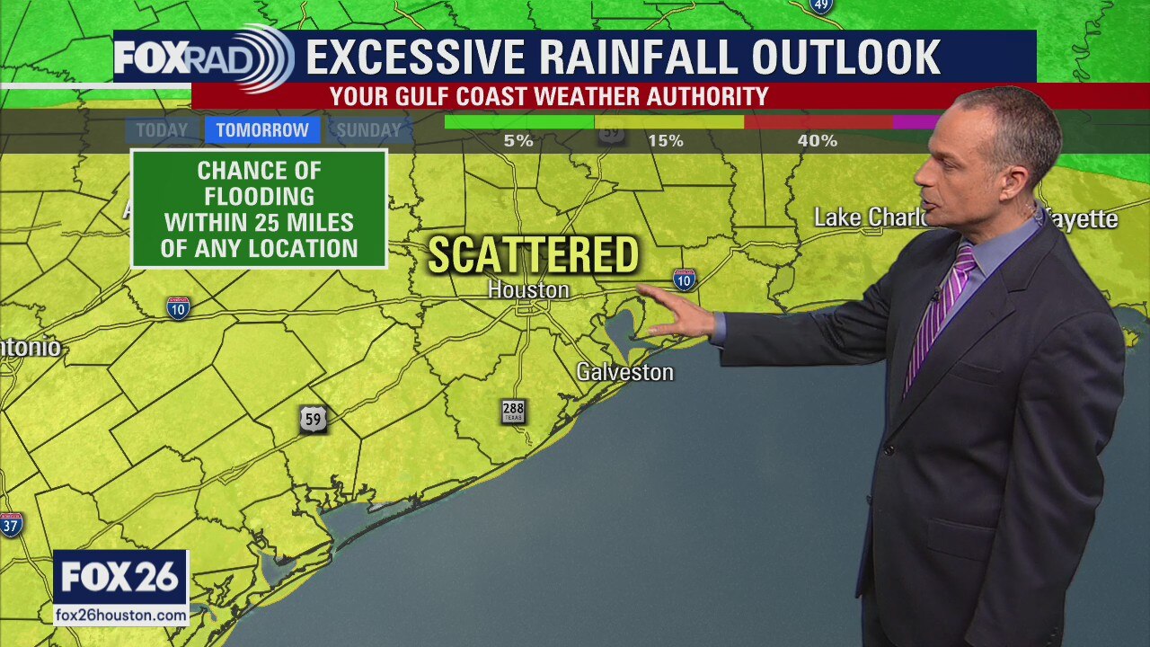
Friday should see warm temperatures and isolated downpours around Houston, very similar to what things looked like on Thursday. The holiday weekend brings the changes with increased chances for rain. Some of those downpours could be heavy and slow moving causing some street flooding. If you have outdoor plans for the holiday on Monday, make sure you have a rain option. There will definitely be scattered showers around Southeast Texas.
Friday should see warm temperatures and isolated downpours around Houston, very similar to what things looked like on Thursday. The holiday weekend brings the changes with increased chances for rain. Some of those downpours could be heavy and slow moving causing some street flooding. If you have outdoor plans for the holiday on Monday, make sure you have a rain option. There will definitely be scattered showers around Southeast Texas.
Thursday evening weather forecast with Meteorologist John Dawson
Friday should see warm temperatures and isolated downpours around Houston, very similar to what things looked like on Thursday. The holiday weekend brings changes with increased chances for rain. Some of those downpours could be heavy and slow-moving causing some street flooding. If you have outdoor plans for the holiday on Monday, make sure you have a rain option. There will definitely be scattered showers around Southeast Texas.
Friday should see warm temperatures and isolated downpours around Houston, very similar to what things looked like on Thursday. The holiday weekend brings changes with increased chances for rain. Some of those downpours could be heavy and slow-moving causing some street flooding. If you have outdoor plans for the holiday on Monday, make sure you have a rain option. There will definitely be scattered showers around Southeast Texas.

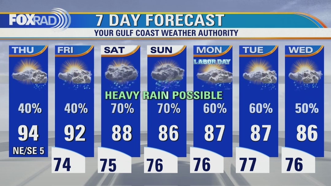
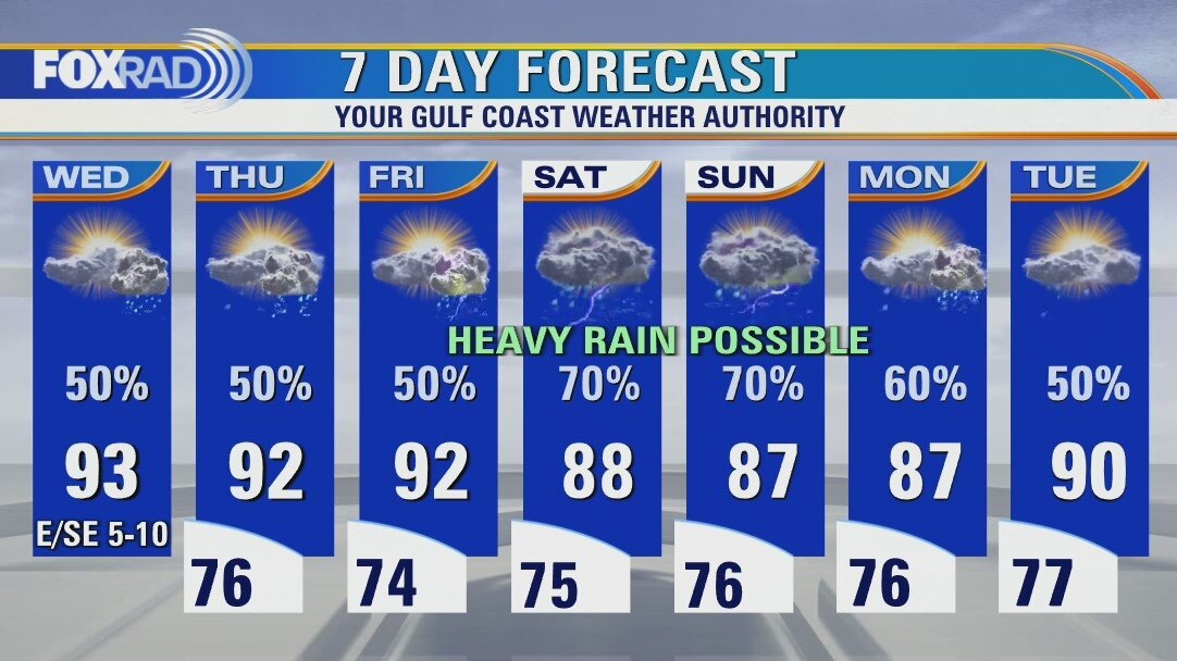
Heavy rain possible over Labor Day weekend
The work week ends on a pretty typical note: partly cloudy, humid with daily afternoon scattered showers or storms. But get ready for another bumpy ride over the long holiday weekend, where rounds of heavy rain will be possible. Tropical Storm Danielle has formed in the north Atlantic Ocean and will not impact the United States in any way, but it's our first named system since Colin over July 4th weekend, 59 days ago.
The work week ends on a pretty typical note: partly cloudy, humid with daily afternoon scattered showers or storms. But get ready for another bumpy ride over the long holiday weekend, where rounds of heavy rain will be possible. Tropical Storm Danielle has formed in the north Atlantic Ocean and will not impact the United States in any way, but it's our first named system since Colin over July 4th weekend, 59 days ago.
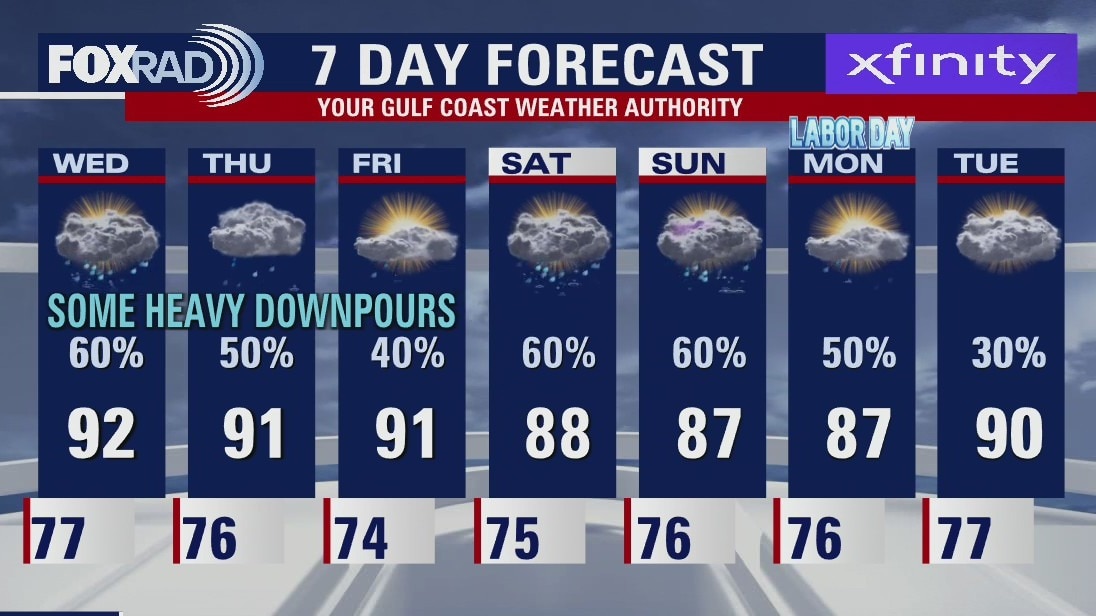
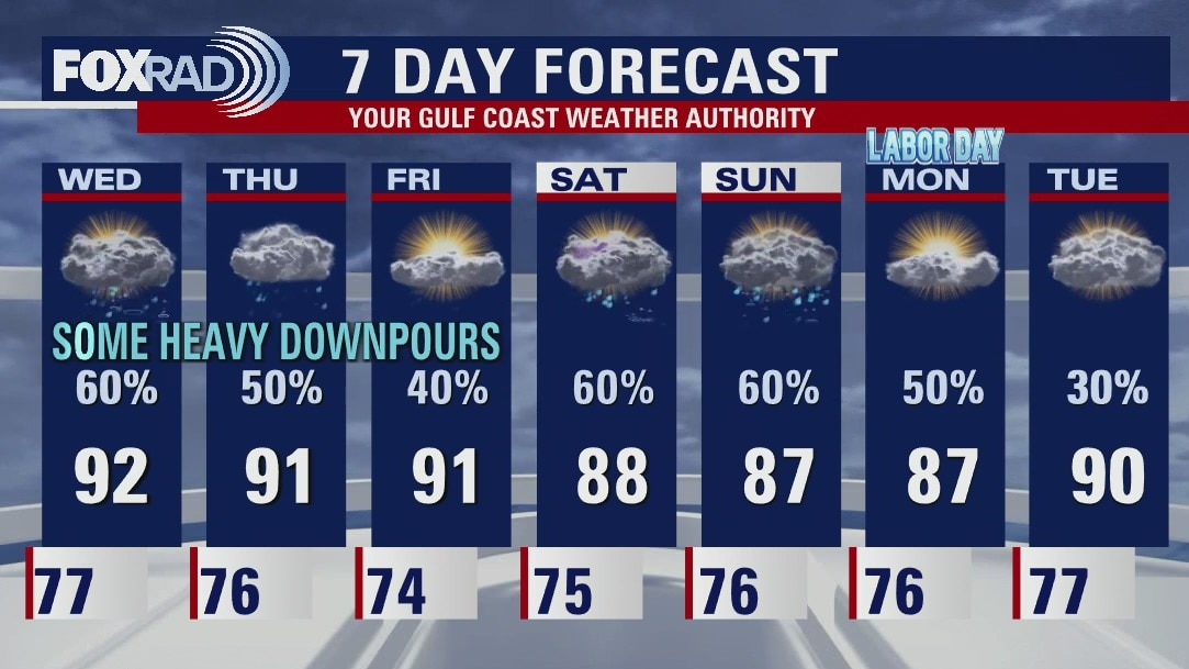
Mostly cloudy and muggy Thursday with isolated afternoon storms
August brought quite the change of pace marking the 10th wettest on record (as measured at Bush Airport) and breaking the trend of excessive heat. September will begin with more of the same - very warm, humid air with pop up afternoon storms. Friday looks similar, but the combination of a stationary front and deep tropical moisture should lead to hefty rain for all three days of the Labor Day weekend. Finally, after the first August since 1997 without a named tropical system, this morning Tropical Depression #5 formed in the north Atlantic Ocean and is no threat to the United States.
August brought quite the change of pace marking the 10th wettest on record (as measured at Bush Airport) and breaking the trend of excessive heat. September will begin with more of the same - very warm, humid air with pop up afternoon storms. Friday looks similar, but the combination of a stationary front and deep tropical moisture should lead to hefty rain for all three days of the Labor Day weekend. Finally, after the first August since 1997 without a named tropical system, this morning Tropical Depression #5 formed in the north Atlantic Ocean and is no threat to the United States.
Thursday morning weather forecast
Houston should see less coverage of afternoon storms to end the work week. There will be isolated downpours around southeast Texas but most will be short lived. The holiday weekend will bring higher rain chances so plan accordingly if you have outdoor plans. The rainy pattern should continue into next week.
Houston should see less coverage of afternoon storms to end the work week. There will be isolated downpours around southeast Texas but most will be short lived. The holiday weekend will bring higher rain chances so plan accordingly if you have outdoor plans. The rainy pattern should continue into next week.
Wednesday evening weather forecast with Meteorologist John Dawson
Houston should see less coverage of afternoon storms to end the work week. There will be isolated downpours around southeast Texas but most will be short-lived. The holiday weekend will bring higher rain chances so plan accordingly if you have outdoor plans. The rainy pattern should continue into next week.
Houston should see less coverage of afternoon storms to end the work week. There will be isolated downpours around southeast Texas but most will be short-lived. The holiday weekend will bring higher rain chances so plan accordingly if you have outdoor plans. The rainy pattern should continue into next week.
Wednesday afternoon weather forecast with Chief Meteorologist Mike Iscovitz
Today is setting up to be a bit different than yesterday with much hotter conditions and storms holding off until the afternoon. We'll keep a good chance for scattered storms around for Thursday and Friday as well. A plume of tropical moisture is expected this weekend, so heavy rain does look likely with a generally unsettled pattern for next week. In the tropics, if the National Hurricane Center does not name any storms today (and it's not likely), this would be the first year since 1997 with no named storms.
Today is setting up to be a bit different than yesterday with much hotter conditions and storms holding off until the afternoon. We'll keep a good chance for scattered storms around for Thursday and Friday as well. A plume of tropical moisture is expected this weekend, so heavy rain does look likely with a generally unsettled pattern for next week. In the tropics, if the National Hurricane Center does not name any storms today (and it's not likely), this would be the first year since 1997 with no named storms.
Mostly cloudy and muggy with scattered showers and storms
Today is setting up to be a bit different than yesterday with much hotter conditions and storms holding off until the afternoon. We'll keep a good chance for scattered storms around for Thursday and Friday as well. A plume of tropical moisture is expected this weekend, so heavy rain does look likely with a generally unsettled pattern for next week. In the tropics, if the National Hurricane Center does not name any storms today (and it's not likely), this would be the first year since 1997 with no named storms.
Today is setting up to be a bit different than yesterday with much hotter conditions and storms holding off until the afternoon. We'll keep a good chance for scattered storms around for Thursday and Friday as well. A plume of tropical moisture is expected this weekend, so heavy rain does look likely with a generally unsettled pattern for next week. In the tropics, if the National Hurricane Center does not name any storms today (and it's not likely), this would be the first year since 1997 with no named storms.
Wednesday morning weather forecast
The rainy pattern continues for Southeast Texas. Expect a few heavy downpours to cause some short term problems in some isolated spots. Your plans for the holiday weekend should include some possible rain. It is not a complete washout but there will definitely be some showers around Houston at times.
The rainy pattern continues for Southeast Texas. Expect a few heavy downpours to cause some short term problems in some isolated spots. Your plans for the holiday weekend should include some possible rain. It is not a complete washout but there will definitely be some showers around Houston at times.
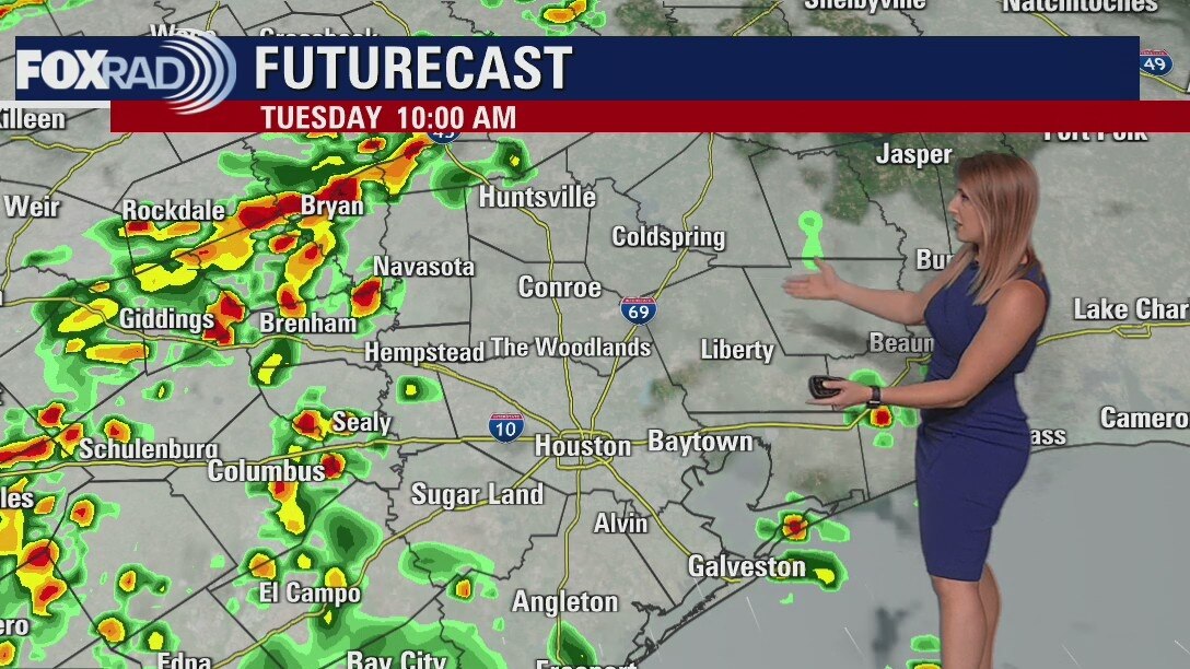
Tuesday evening weather forecast
The rainy pattern continues for Southeast Texas. Expect a few heavy downpours to cause some short-term problems in some isolated spots. Your plans for the holiday weekend should include some possible rain. It is not a complete washout, but there will definitely be some showers around Houston at times.
The rainy pattern continues for Southeast Texas. Expect a few heavy downpours to cause some short-term problems in some isolated spots. Your plans for the holiday weekend should include some possible rain. It is not a complete washout, but there will definitely be some showers around Houston at times.
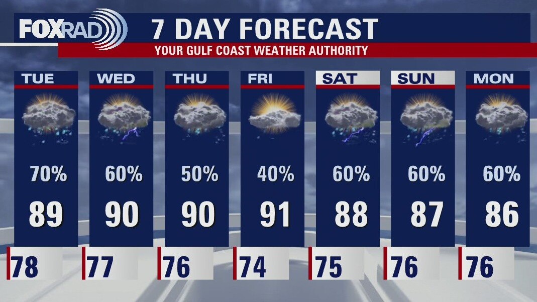
Mostly cloudy and humid Tuesday with more heavy storms possible
Our rainy pattern is likely to continue for the next week. Watch for a mix of mostly cloudy and muggy conditions with rounds of downpours that could drop a quick 2" of rain or more. A couple of good effects of all this rain are that the drought is coming to an end in many locations and our temperatures for the month of August were exactly normal as opposed to three straight months with record warmth.
Our rainy pattern is likely to continue for the next week. Watch for a mix of mostly cloudy and muggy conditions with rounds of downpours that could drop a quick 2" of rain or more. A couple of good effects of all this rain are that the drought is coming to an end in many locations and our temperatures for the month of August were exactly normal as opposed to three straight months with record warmth.
Tuesday morning weather forecast
An active weather pattern continues with rounds of rain and storms through the rest of the week. Some of the rain will be heavy at times and localized flooding will be possible. The silver linings to the rainy forecast are drought relief and below average temperatures. Highs will hover near 90 the next several days.
An active weather pattern continues with rounds of rain and storms through the rest of the week. Some of the rain will be heavy at times and localized flooding will be possible. The silver linings to the rainy forecast are drought relief and below average temperatures. Highs will hover near 90 the next several days.
Monday evening weather forecast
An active weather pattern continues with rounds of rain and storms through the rest of the week. Some of the rain will be heavy at times and localized flooding will be possible. The silver linings to the rainy forecast are drought relief and below average temperatures. Highs will hover near 90 the next several days.
An active weather pattern continues with rounds of rain and storms through the rest of the week. Some of the rain will be heavy at times and localized flooding will be possible. The silver linings to the rainy forecast are drought relief and below average temperatures. Highs will hover near 90 the next several days.
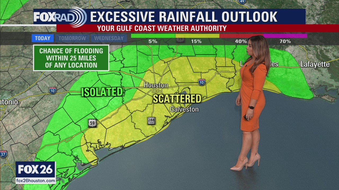
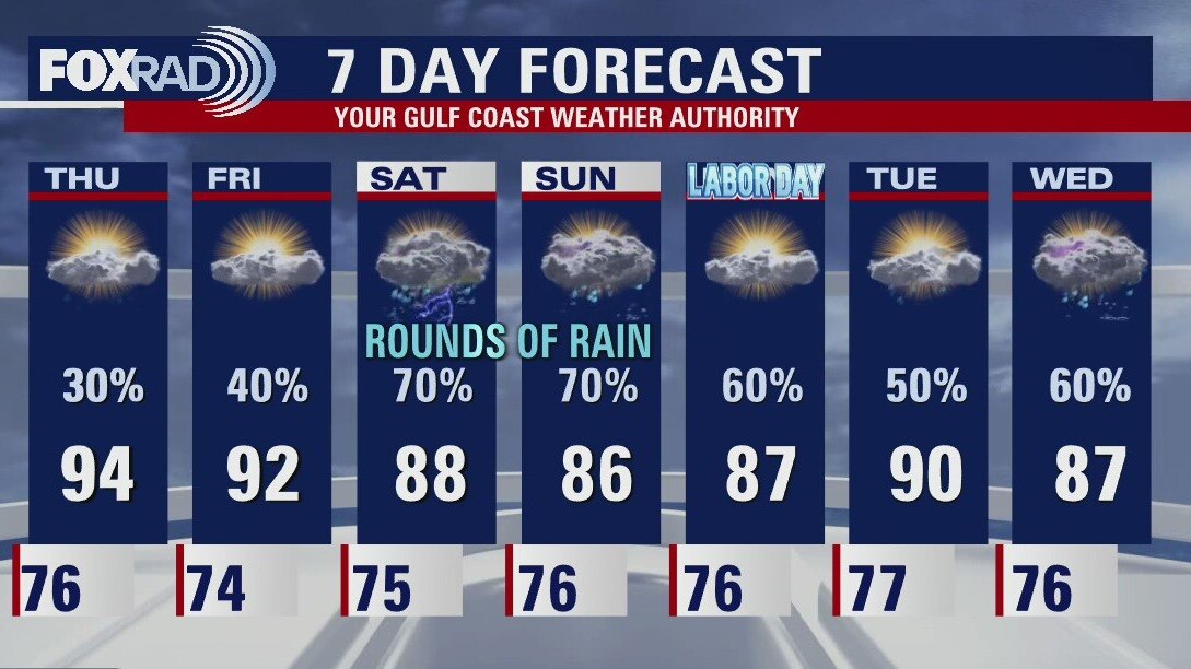
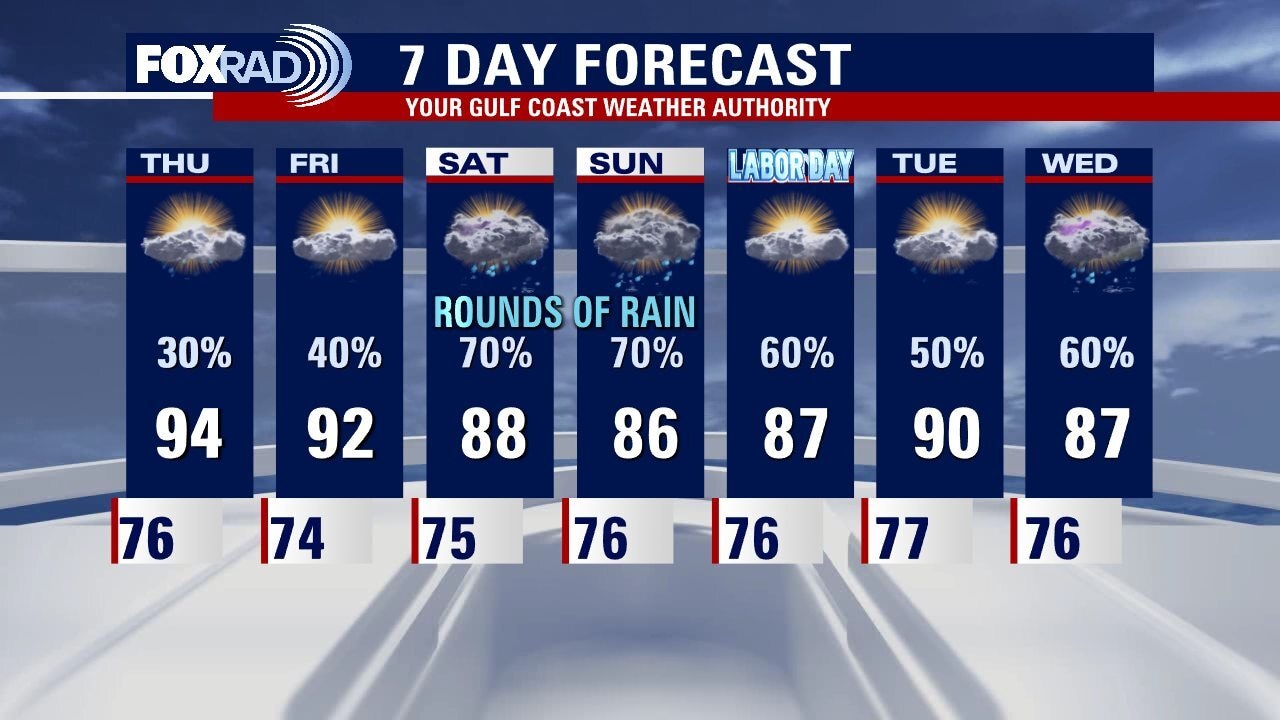
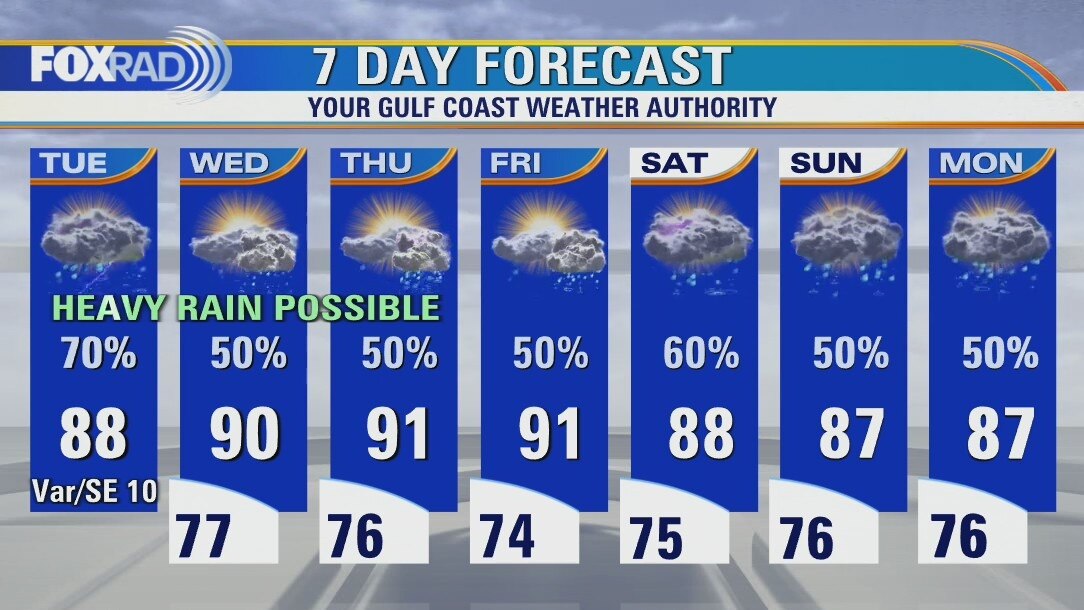
More rounds of heavy rain expected Tuesday
Several inches of rain accompanied by gusty winds have already occurred across much of our area today, with activity expected to wind down by early evening. Rounds of heavy rain return tomorrow, and potentially into Wednesday as an area of disturbed weather continues to funnel a deep plume of Gulf moisture our way. Allow for plenty of extra time to navigate around possible flooding on roads through Wednesday. By the end of the week, a front looks to approach and stall keeping us unsettled for the long holiday weekend. On a positive note: although the tropics are becoming more active, everything is staying away from us for now.
Several inches of rain accompanied by gusty winds have already occurred across much of our area today, with activity expected to wind down by early evening. Rounds of heavy rain return tomorrow, and potentially into Wednesday as an area of disturbed weather continues to funnel a deep plume of Gulf moisture our way. Allow for plenty of extra time to navigate around possible flooding on roads through Wednesday. By the end of the week, a front looks to approach and stall keeping us unsettled for the long holiday weekend. On a positive note: although the tropics are becoming more active, everything is staying away from us for now.
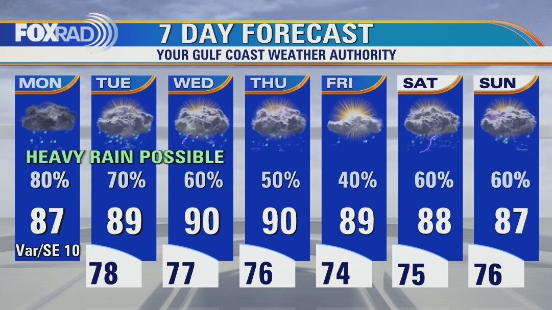
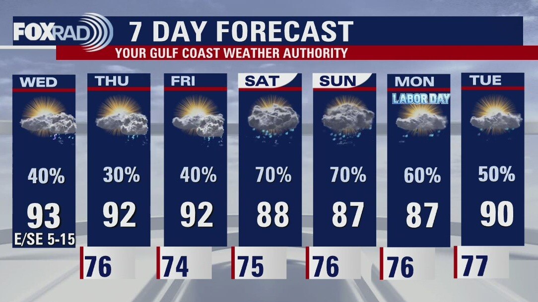
Highs upper 80s with periods of heavy rain expected today
Periods of heavy rain are likely through midweek, so allow for plenty of extra time to navigate the roadways. Rain chances look to taper toward the end of the week, as a front approaches and stalls. That looks to drive rain chances back up over the long holiday weekend. Hopefully you're enjoying the seasonably cool temperatures as we climb our way out of the drought! Lots to watch in the Atlantic Basin as we approach the peak of Hurricane Season, though nothing is cause for local concern at this time.
Periods of heavy rain are likely through midweek, so allow for plenty of extra time to navigate the roadways. Rain chances look to taper toward the end of the week, as a front approaches and stalls. That looks to drive rain chances back up over the long holiday weekend. Hopefully you're enjoying the seasonably cool temperatures as we climb our way out of the drought! Lots to watch in the Atlantic Basin as we approach the peak of Hurricane Season, though nothing is cause for local concern at this time.
Sunday night leading into Monday morning weather forecast
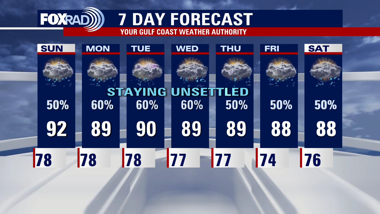
Get ready for a bumpy ride as we start the week. It looks like a plume of deep moisture will move into our area and bring a high chance for storms and the likelihood that some will be heavy, especially on Monday and Tuesday. 1-2? rainfall will be common, some slow-moving storms could drop 3? or more, so stay alert for localized street flooding. Otherwise, look for humid weather with below-average temperatures for the next several days.
Get ready for a bumpy ride as we start the week. It looks like a plume of deep moisture will move into our area and bring a high chance for storms and the likelihood that some will be heavy, especially on Monday and Tuesday. 1-2? rainfall will be common, some slow-moving storms could drop 3? or more, so stay alert for localized street flooding. Otherwise, look for humid weather with below-average temperatures for the next several days.


Sunday Morning Forecast with Meteorologist Lena Maria Arango
Localized heavy rainfall looks likely on Monday, so plan for extra time for both AM and PM commutes. We'll be staying fairy unsettled throughout the week, with daytime highs driven down by increased cloud cover and on and off rain. NHC is now monitoring 4 areas in the Atlantic Basin, most with low probabilities for development and no local concerns at this time. But, the peak of Hurricane Season is less than 2 weeks away so if you haven't prepared yet, now is certainly the time to do so.
Localized heavy rainfall looks likely on Monday, so plan for extra time for both AM and PM commutes. We'll be staying fairy unsettled throughout the week, with daytime highs driven down by increased cloud cover and on and off rain. NHC is now monitoring 4 areas in the Atlantic Basin, most with low probabilities for development and no local concerns at this time. But, the peak of Hurricane Season is less than 2 weeks away so if you haven't prepared yet, now is certainly the time to do so.
Saturday night leading into Sunday morning weather forecast
Daily rain and storm chances continue into next week. Some of the rain could be heavy at times, and localized flooding will be possible. With the rain and added clouds around, temperatures will continue to stay seasonably cool. High temps will just climb into the upper 80s and low 90s.
Daily rain and storm chances continue into next week. Some of the rain could be heavy at times, and localized flooding will be possible. With the rain and added clouds around, temperatures will continue to stay seasonably cool. High temps will just climb into the upper 80s and low 90s.