


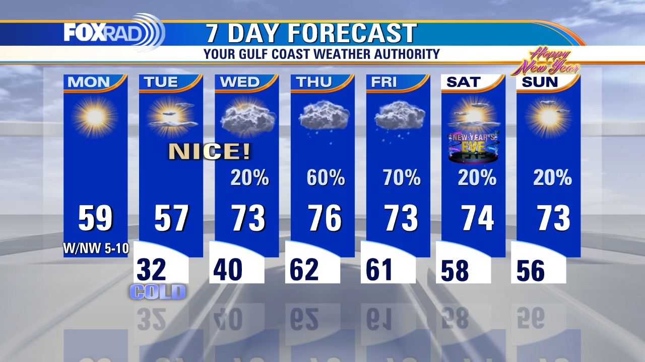
One more night of freezing temperatures before warmer weather
A big pattern change is on the way this week with much warmer and eventually wetter weather heading to Southeast Texas. We will have one more night with a possible light freeze as we dip to around 32 overnight. A weak cold front moving through Monday evening will mean temperatures a few degrees cooler Tuesday in the mid, to upper 50s. By Wednesday, southerly flow kicks in big time, and that will bring in more moisture and warmer temps. Thursday will be warm in the 70s but wet with heavy rain a good bet with our next storm system. Right now, New Year's weekend looks mild and mainly dry with only a stray shower possible.
A big pattern change is on the way this week with much warmer and eventually wetter weather heading to Southeast Texas. We will have one more night with a possible light freeze as we dip to around 32 overnight. A weak cold front moving through Monday evening will mean temperatures a few degrees cooler Tuesday in the mid, to upper 50s. By Wednesday, southerly flow kicks in big time, and that will bring in more moisture and warmer temps. Thursday will be warm in the 70s but wet with heavy rain a good bet with our next storm system. Right now, New Year's weekend looks mild and mainly dry with only a stray shower possible.
Monday morning weather forecast with Chief Meteorologist Mike Iscovitz
This morning marked the 4th freezing low temperature in a row, but a gradual warming trend is about to kick in. Today's high should reach the upper 50s followed by a similar day Tuesday - lows in the 30s and highs in the 50s. A south wind returns Wednesday bringing much milder air, more clouds, and a high chance for rain on Thursday. A mild pattern will be in place at to the end of 2022 and begin the new year.
This morning marked the 4th freezing low temperature in a row, but a gradual warming trend is about to kick in. Today's high should reach the upper 50s followed by a similar day Tuesday - lows in the 30s and highs in the 50s. A south wind returns Wednesday bringing much milder air, more clouds, and a high chance for rain on Thursday. A mild pattern will be in place at to the end of 2022 and begin the new year.

Sunday leading into Monday morning weather forecast with Meteorologist Remeisha Shade
Although we will have one more night of freezing temperatures in the middle 20s to 30s, at least we are not talking about a HARD FREEZE WARNING or WIND CHILL ADVISORY. We should dip to near 30 degrees tonight in Houston with light and variable wind. The first few days of the new week should be mostly sunny, cool, and quiet with highs near 60. A huge warming trend is in store by the middle and end of the week with the 70s likely! Look for a decent chance for showers and thunderstorms late Thursday into Friday. There's just a slim chance of rain showing up for New Year's Eve plans.
Although we will have one more night of freezing temperatures in the middle 20s to 30s, at least we are not talking about a HARD FREEZE WARNING or WIND CHILL ADVISORY. We should dip to near 30 degrees tonight in Houston with light and variable wind. The first few days of the new week should be mostly sunny, cool, and quiet with highs near 60. A huge warming trend is in store by the middle and end of the week with the 70s likely! Look for a decent chance for showers and thunderstorms late Thursday into Friday. There's just a slim chance of rain showing up for New Year's Eve plans.
Christmas Day weather forecast with Chief Meteorologist Mike Iscovitz
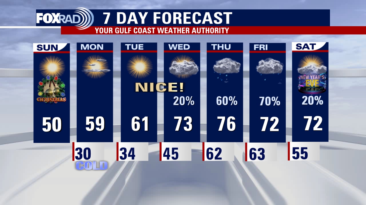
After another hard freeze on Christmas morning, we will remain chilly for the next few days, but you'll notice a prolonged warming trend. Look for more cold mornings, but milder days with a high near 50 today, then closer to 60 on Monday. We could hit the mid-70s later this week, but rain will also return with high chances on both Thursday and Friday.
After another hard freeze on Christmas morning, we will remain chilly for the next few days, but you'll notice a prolonged warming trend. Look for more cold mornings, but milder days with a high near 50 today, then closer to 60 on Monday. We could hit the mid-70s later this week, but rain will also return with high chances on both Thursday and Friday.
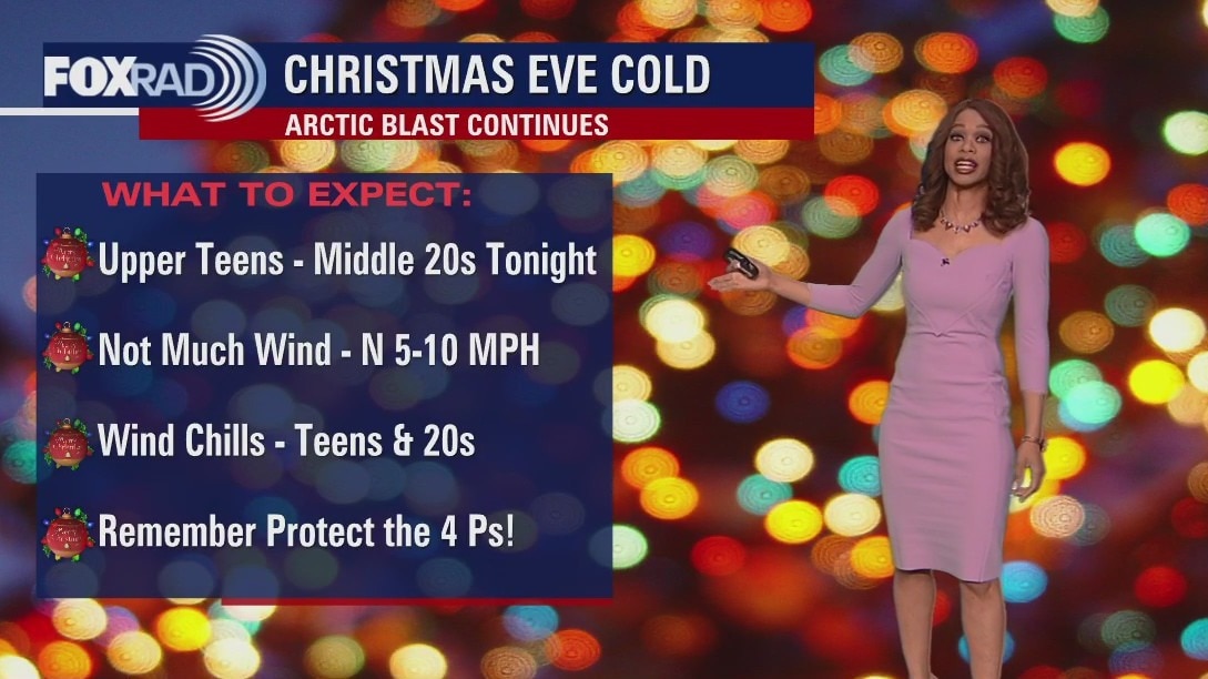
Christmas Eve temps in the 10s, 20s so stay warm!
Another Hard Freeze Warning is in effect for all of SE Texas from 7 p.m. tonight through 11 a.m. Christmas morning. Remember to keep dressing in layers and limit your time outdoors. Also, make sure your pets are safe and warm too! It will be a sunny Christmas Day with temperatures rebounding to the upper 40s by the afternoon. A big warming trend is on the way for next week with the 70s returning by Wednesday! There will be a decent shot for showers and a few storms Thursday and Friday. Happy holidays!
Another Hard Freeze Warning is in effect for all of SE Texas from 7 p.m. tonight through 11 a.m. Christmas morning. Remember to keep dressing in layers and limit your time outdoors. Also, make sure your pets are safe and warm too! It will be a sunny Christmas Day with temperatures rebounding to the upper 40s by the afternoon. A big warming trend is on the way for next week with the 70s returning by Wednesday! There will be a decent shot for showers and a few storms Thursday and Friday. Happy holidays!
Christmas weekend weather forecast, Hard Freeze Warning
Arctic Air remains entrenched across Southeast Texas with more dangerously cold temperatures in the teens and low 20s expected overnight. A Hard Freeze Warning continues for Southeast Texas until Noon Saturday & a Wind Chill Advisory is now in effect until 10 a.m. Saturday. Wind chill values are expected to dip into the single digits and low teens overnight which will once again create a frostbite danger to exposed skin. Christmas Eve and Christmas Day will have chilly starts but we will climb to near 40 Saturday and close to 50 Sunday. Big time warming trend is in store next week as we get close to wrapping up 2022. 70s are back by Wednesday and Thursday! For now though, make sure you are staying safe and protecting yourself, pipes, plants & pets from the cold!
Arctic Air remains entrenched across Southeast Texas with more dangerously cold temperatures in the teens and low 20s expected overnight. A Hard Freeze Warning continues for Southeast Texas until Noon Saturday & a Wind Chill Advisory is now in effect until 10 a.m. Saturday. Wind chill values are expected to dip into the single digits and low teens overnight which will once again create a frostbite danger to exposed skin. Christmas Eve and Christmas Day will have chilly starts but we will climb to near 40 Saturday and close to 50 Sunday. Big time warming trend is in store next week as we get close to wrapping up 2022. 70s are back by Wednesday and Thursday! For now though, make sure you are staying safe and protecting yourself, pipes, plants & pets from the cold!

Frigid temps, single digit wind chill Friday evening
Arctic Air remains entrenched across SE Texas with more dangerously cold temperatures in the teens and low 20s expected overnight. A Hard Freeze Warning continues for SE Texas until noon Saturday and a Wind Chill Advisory is now in effect until 10 a.m. Saturday. Wind chill values are expected to dip into the single digits and low teens overnight which will once again create a frostbite danger to exposed skin. Christmas Eve and Christmas Day will have chilly starts but we will climb to near 40 Saturday and close to 50 Sunday. Big time warming trend is in store next week as we get close to wrapping up 2022. 70s are back by Wednesday and Thursday! For now though, make sure you are staying safe and protecting yourself, pipes, plants, and pets from the cold!
Arctic Air remains entrenched across SE Texas with more dangerously cold temperatures in the teens and low 20s expected overnight. A Hard Freeze Warning continues for SE Texas until noon Saturday and a Wind Chill Advisory is now in effect until 10 a.m. Saturday. Wind chill values are expected to dip into the single digits and low teens overnight which will once again create a frostbite danger to exposed skin. Christmas Eve and Christmas Day will have chilly starts but we will climb to near 40 Saturday and close to 50 Sunday. Big time warming trend is in store next week as we get close to wrapping up 2022. 70s are back by Wednesday and Thursday! For now though, make sure you are staying safe and protecting yourself, pipes, plants, and pets from the cold!

Frigid Friday morning with temps in teens, then sunny but very cold day
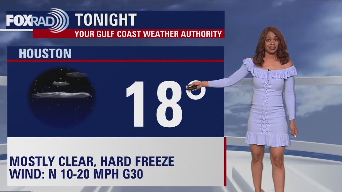
This morning's low temperatures were the coldest since the infamous freeze of 2021 and lows tonight could be in the teens again. A hard freeze warning is in effect through noon on Christmas Eve and temperatures could struggle to reach the low 30s today and upper 30s tomorrow. Christmas morning looks slightly less frigid, but still very cold, but by Christmas afternoon it should feel much better with sunny skies and highs in the upper 40s. By the middle of next week, believe it or not, our highs could reach into the mid 70s! In the meantime, please stay warm and stay safe.
This morning's low temperatures were the coldest since the infamous freeze of 2021 and lows tonight could be in the teens again. A hard freeze warning is in effect through noon on Christmas Eve and temperatures could struggle to reach the low 30s today and upper 30s tomorrow. Christmas morning looks slightly less frigid, but still very cold, but by Christmas afternoon it should feel much better with sunny skies and highs in the upper 40s. By the middle of next week, believe it or not, our highs could reach into the mid 70s! In the meantime, please stay warm and stay safe.
Friday morning weather forecast
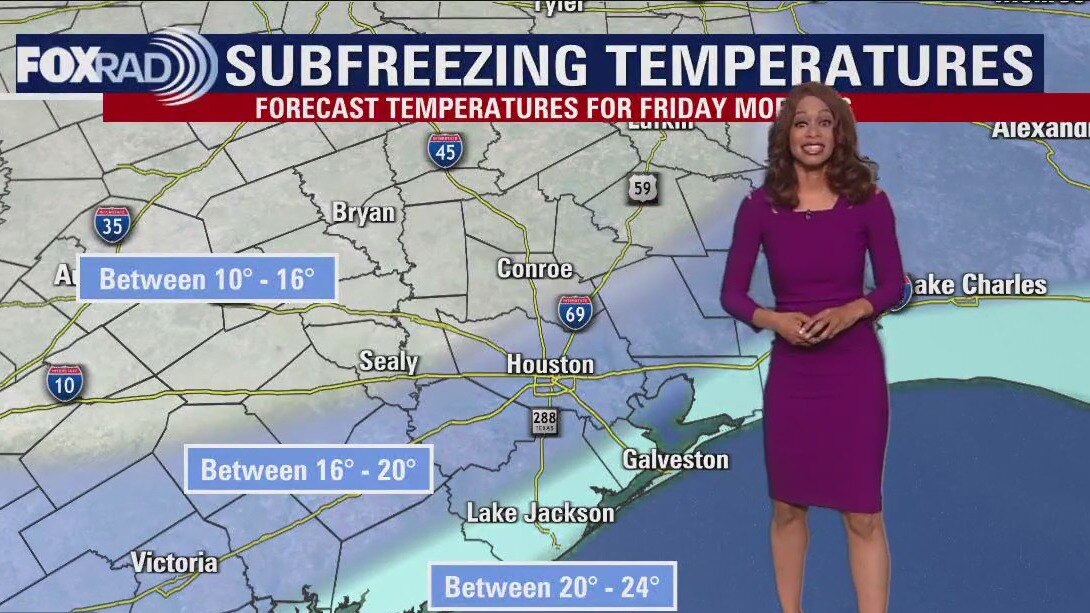
Arctic Air has arrived in Houston! Temperatures are on their way to dangerous levels in the teens and 20s tonight with wind chill values near zero! Make sure the 4 P's are protected - People, Pets, Plants & Pipes. Also limit the amount of time you spend outside. A Hard Freeze Warning is in effect for SE Texas from 6 p.m. Thursday until Noon Saturday. A Wind Chill Warning is in effect from 6 p.m. Thursday to Noon Friday. A Wind Advisory is in effect until midnight inland and until Noon Friday along the coast. Some parts of SE Texas may stay below freezing for 36-46 hours so make sure you are staying safe and protecting yourself from the cold! Look for high temperatures near freezing Friday and another hard freeze Friday night into early Saturday. We should finally climb above freezing to near 40 by Saturday afternoon for Christmas Eve. After starting off in the 20s on Christmas Day, temps should be near 50 by the afternoon. Christmas holiday weekend should be chilly but sunny and dry. Look for an impressive warmup next week as 70s are expected to return!
Arctic Air has arrived in Houston! Temperatures are on their way to dangerous levels in the teens and 20s tonight with wind chill values near zero! Make sure the 4 P's are protected - People, Pets, Plants & Pipes. Also limit the amount of time you spend outside. A Hard Freeze Warning is in effect for SE Texas from 6 p.m. Thursday until Noon Saturday. A Wind Chill Warning is in effect from 6 p.m. Thursday to Noon Friday. A Wind Advisory is in effect until midnight inland and until Noon Friday along the coast. Some parts of SE Texas may stay below freezing for 36-46 hours so make sure you are staying safe and protecting yourself from the cold! Look for high temperatures near freezing Friday and another hard freeze Friday night into early Saturday. We should finally climb above freezing to near 40 by Saturday afternoon for Christmas Eve. After starting off in the 20s on Christmas Day, temps should be near 50 by the afternoon. Christmas holiday weekend should be chilly but sunny and dry. Look for an impressive warmup next week as 70s are expected to return!
Bundle up as temps drop into 20-30s Thursday evening
Arctic Air has arrived in Houston! Temperatures are on their way to dangerous levels in the teens and 20s tonight with wind chill values near zero! Make sure the 4 P's are protected - People, Pets, Plants & Pipes. Also limit the amount of time you spend outside. A Hard Freeze Warning is in effect for SE Texas from 6 p.m. Thursday until noon Saturday. A Wind Chill Warning is in effect from 6 p.m. Thursday to Noon Friday. A Wind Advisory is in effect until midnight inland and until noon Friday along the coast. Some parts of SE Texas may stay below freezing for 36-46 hours so make sure you are staying safe and protecting yourself from the cold! Look for high temperatures near freezing Friday and another hard freeze Friday night into early Saturday. We should finally climb above freezing to near 40 by Saturday afternoon for Christmas Eve. After starting off in the 20s on Christmas Day, temps should be near 50 by the afternoon. Christmas holiday weekend should be chilly but sunny and dry. Look for an impressive warmup next week as 70s are expected to return!
Arctic Air has arrived in Houston! Temperatures are on their way to dangerous levels in the teens and 20s tonight with wind chill values near zero! Make sure the 4 P's are protected - People, Pets, Plants & Pipes. Also limit the amount of time you spend outside. A Hard Freeze Warning is in effect for SE Texas from 6 p.m. Thursday until noon Saturday. A Wind Chill Warning is in effect from 6 p.m. Thursday to Noon Friday. A Wind Advisory is in effect until midnight inland and until noon Friday along the coast. Some parts of SE Texas may stay below freezing for 36-46 hours so make sure you are staying safe and protecting yourself from the cold! Look for high temperatures near freezing Friday and another hard freeze Friday night into early Saturday. We should finally climb above freezing to near 40 by Saturday afternoon for Christmas Eve. After starting off in the 20s on Christmas Day, temps should be near 50 by the afternoon. Christmas holiday weekend should be chilly but sunny and dry. Look for an impressive warmup next week as 70s are expected to return!

Plunging temperature and high winds Thursday afternoon
Prepare for a shocking arrival of wind chills, seriously high winds and two nights of damaging hard freezes. Beginning at noon today, a wind advisory goes into effect as north winds could gust above 40 mph. A hard freeze warning and wind chill warning begin at 6 p.m. meaning that wind chill values could drop into the dangerous single digits tonight along with the start of a major freeze that could keep many areas below freezing for more than 36 hours. Christmas Eve and Christmas Day will both begin with freeing temps and chilly afternoons. The good news with this freeze as compared to the the freeze of February 2021, is that this one should be very dry, so there is a very low risk of icy roads. Next week, high temps could reach the low 70s.
Prepare for a shocking arrival of wind chills, seriously high winds and two nights of damaging hard freezes. Beginning at noon today, a wind advisory goes into effect as north winds could gust above 40 mph. A hard freeze warning and wind chill warning begin at 6 p.m. meaning that wind chill values could drop into the dangerous single digits tonight along with the start of a major freeze that could keep many areas below freezing for more than 36 hours. Christmas Eve and Christmas Day will both begin with freeing temps and chilly afternoons. The good news with this freeze as compared to the the freeze of February 2021, is that this one should be very dry, so there is a very low risk of icy roads. Next week, high temps could reach the low 70s.
Thursday morning weather forecast
A Hard Freeze Warning is now in effect for SE Texas from 6 p.m. Thursday until noon Saturday. A Wind Chill Warning is in effect from 6 p.m. Thursday to noon Friday. A Wind Advisory is in effect from noon Thursday to midnight Thursday night inland and until Noon Friday along the coast. Temperatures Thursday will start off in the 40s early and climb to the 60s by early afternoon. The strong arctic front will roll in by 1-2 pm and send temps crashing to the 40s by 3-4 pm and around freezing by 7 pm. Temperatures will bottom out in the teens to low 20s by early Friday morning. On top of that wind will pick up switching from the south to the north early Thursday PM with gusts of 30-40 mph inland and 40-50 mph along the coast. We will likely stay below freezing for 36-46 hours so make sure your home is winterized and you are prepared to wear extra layers! Also, make sure your pets are safe and warm and plants are protected. The cold won't stick around for long because our weather models are already hinting at 70s by the middle of next week!
A Hard Freeze Warning is now in effect for SE Texas from 6 p.m. Thursday until noon Saturday. A Wind Chill Warning is in effect from 6 p.m. Thursday to noon Friday. A Wind Advisory is in effect from noon Thursday to midnight Thursday night inland and until Noon Friday along the coast. Temperatures Thursday will start off in the 40s early and climb to the 60s by early afternoon. The strong arctic front will roll in by 1-2 pm and send temps crashing to the 40s by 3-4 pm and around freezing by 7 pm. Temperatures will bottom out in the teens to low 20s by early Friday morning. On top of that wind will pick up switching from the south to the north early Thursday PM with gusts of 30-40 mph inland and 40-50 mph along the coast. We will likely stay below freezing for 36-46 hours so make sure your home is winterized and you are prepared to wear extra layers! Also, make sure your pets are safe and warm and plants are protected. The cold won't stick around for long because our weather models are already hinting at 70s by the middle of next week!

Hard Freeze Warning, temps in the 50s Wednesday evening
A Hard Freeze Warning is now in effect for SE Texas from 6 p.m. Thursday until noon Saturday. A Wind Chill Warning is in effect from 6 p.m. Thursday to noon Friday. A Wind Advisory is in effect from noon Thursday to midnight Thursday night inland and until Noon Friday along the coast. Temperatures Thursday will start off in the 40s early and climb to the 60s by early afternoon. The strong arctic front will roll in by 1-2 pm and send temps crashing to the 40s by 3-4 pm and around freezing by 7 pm. Temperatures will bottom out in the teens to low 20s by early Friday morning. On top of that wind will pick up switching from the south to the north early Thursday PM with gusts of 30-40 mph inland and 40-50 mph along the coast. We will likely stay below freezing for 36-46 hours so make sure your home is winterized and you are prepared to wear extra layers! Also, make sure your pets are safe and warm and plants are protected. The cold won't stick around for long because our weather models are already hinting at 70s by the middle of next week!
A Hard Freeze Warning is now in effect for SE Texas from 6 p.m. Thursday until noon Saturday. A Wind Chill Warning is in effect from 6 p.m. Thursday to noon Friday. A Wind Advisory is in effect from noon Thursday to midnight Thursday night inland and until Noon Friday along the coast. Temperatures Thursday will start off in the 40s early and climb to the 60s by early afternoon. The strong arctic front will roll in by 1-2 pm and send temps crashing to the 40s by 3-4 pm and around freezing by 7 pm. Temperatures will bottom out in the teens to low 20s by early Friday morning. On top of that wind will pick up switching from the south to the north early Thursday PM with gusts of 30-40 mph inland and 40-50 mph along the coast. We will likely stay below freezing for 36-46 hours so make sure your home is winterized and you are prepared to wear extra layers! Also, make sure your pets are safe and warm and plants are protected. The cold won't stick around for long because our weather models are already hinting at 70s by the middle of next week!
Hard freeze watch as arctic blast approaches, chilly Wednesday afternoon
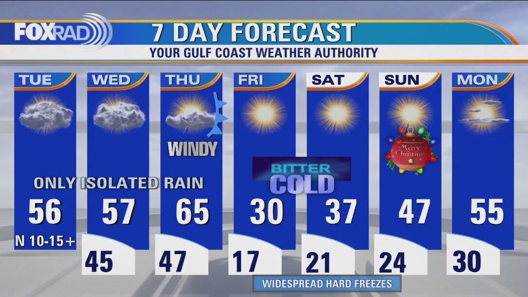
You've got 24 hours to get those preps done before the Polar Express comes screeching into the station. Howling winds will drain in dangerously cold air, resulting in single-digit and negative wind chills. Limit time outside for you and your pets, especially during the coldest parts of the day. At least two nights of hard freezes are likely, in addition to scattered power outages from winds and bitter afternoons. Good wind/solar supply should help the grid's demands, but be ready for anything and that includes major travel implications. After shivering our way through Christmas, New Year's looks to be quite the treat with temperatures rising above average for much of the nation!
You've got 24 hours to get those preps done before the Polar Express comes screeching into the station. Howling winds will drain in dangerously cold air, resulting in single-digit and negative wind chills. Limit time outside for you and your pets, especially during the coldest parts of the day. At least two nights of hard freezes are likely, in addition to scattered power outages from winds and bitter afternoons. Good wind/solar supply should help the grid's demands, but be ready for anything and that includes major travel implications. After shivering our way through Christmas, New Year's looks to be quite the treat with temperatures rising above average for much of the nation!
Chilly Wednesday with highs in mid-50s
Take advantage of today's quiet weather to make your final preparations for tomorrow's arctic blast. Gas up the car, get those non-perishable foods, wrap pipes, cover plants, the whole shebang before dangerous cold plows in around midday tomorrow. Wind chills could get close to zero and this will be the coldest air since the Presidents Day freeze 2021. One bit of good news is that icy roads are much less likely this time except in areas where sprinklers or other pipes coat a street. Weather should be clear and cold for Christmas.
Take advantage of today's quiet weather to make your final preparations for tomorrow's arctic blast. Gas up the car, get those non-perishable foods, wrap pipes, cover plants, the whole shebang before dangerous cold plows in around midday tomorrow. Wind chills could get close to zero and this will be the coldest air since the Presidents Day freeze 2021. One bit of good news is that icy roads are much less likely this time except in areas where sprinklers or other pipes coat a street. Weather should be clear and cold for Christmas.
Wednesday morning weather forecast
Preparations for our dangerous arctic blast should be completed by Thursday morning! Weather should remain cool and quiet tonight and Wednesday with just a slim chance for a shower. Major arctic blast will arrive by Thursday afternoon sending temperatures down into the teens and 20s by early Friday. Wind gusts of 30-40 mph will also mean dangerous wind chill values near zero late Thursday and early Friday. Hard Freeze Watch is in effect for SE Texas from Noon Thursday - Noon Saturday. Wind Chill Watch is in effect from 6 PM Thursday until Noon Friday. Scattered power outages due to the strong wind will be possible late Thursday into early Friday. At least we are not expecting any snow or ice with this event, just chilly temps. Still make sure your home is winterized with your pets, plants & pipes protected. Also don't forget to wear extra layers while outside during this cold spell. Much warmer temps look to return by the middle of next week!
Preparations for our dangerous arctic blast should be completed by Thursday morning! Weather should remain cool and quiet tonight and Wednesday with just a slim chance for a shower. Major arctic blast will arrive by Thursday afternoon sending temperatures down into the teens and 20s by early Friday. Wind gusts of 30-40 mph will also mean dangerous wind chill values near zero late Thursday and early Friday. Hard Freeze Watch is in effect for SE Texas from Noon Thursday - Noon Saturday. Wind Chill Watch is in effect from 6 PM Thursday until Noon Friday. Scattered power outages due to the strong wind will be possible late Thursday into early Friday. At least we are not expecting any snow or ice with this event, just chilly temps. Still make sure your home is winterized with your pets, plants & pipes protected. Also don't forget to wear extra layers while outside during this cold spell. Much warmer temps look to return by the middle of next week!
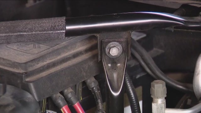

Preparing your vehicle for the winter freeze, what you need to know
As we prepare for that winter freeze, FOX 26’s Gabby Hart shares an important reminder on how to ensure your vehicle is ready for the cold weather.
As we prepare for that winter freeze, FOX 26’s Gabby Hart shares an important reminder on how to ensure your vehicle is ready for the cold weather.

Tuesday evening weather forecast with Meteorologist Remeisha Shade
Preparations for our dangerous arctic blast should be completed by Thursday morning! Weather should remain cool and quiet tonight and Wednesday with just a slim chance for a shower. Major arctic blast will arrive by Thursday afternoon sending temperatures down into the teens and 20s by early Friday. Wind gusts of 30-40 mph will also mean dangerous wind chill values near zero late Thursday and early Friday. Hard Freeze Watch is in effect for SE Texas from Noon Thursday - Noon Saturday. Wind Chill Watch is in effect from 6 PM Thursday until Noon Friday. Scattered power outages due to the strong wind will be possible late Thursday into early Friday. At least we are not expecting any snow or ice with this event, just chilly temps. Still make sure your home is winterized with your pets, plants & pipes protected. Also don't forget to wear extra layers while outside during this cold spell. Much warmer temps look to return by the middle of next week!
Preparations for our dangerous arctic blast should be completed by Thursday morning! Weather should remain cool and quiet tonight and Wednesday with just a slim chance for a shower. Major arctic blast will arrive by Thursday afternoon sending temperatures down into the teens and 20s by early Friday. Wind gusts of 30-40 mph will also mean dangerous wind chill values near zero late Thursday and early Friday. Hard Freeze Watch is in effect for SE Texas from Noon Thursday - Noon Saturday. Wind Chill Watch is in effect from 6 PM Thursday until Noon Friday. Scattered power outages due to the strong wind will be possible late Thursday into early Friday. At least we are not expecting any snow or ice with this event, just chilly temps. Still make sure your home is winterized with your pets, plants & pipes protected. Also don't forget to wear extra layers while outside during this cold spell. Much warmer temps look to return by the middle of next week!

Tuesday afternoon weather forecast with Meteorologist Remeisha Shade
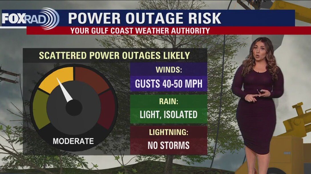
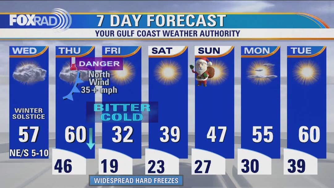
Cloudy, cool & quiet with only isolated rain through Thursday morning so you've got until then to complete Christmas + 4 P preps. Scattered power outages due to gusty winds up around 40mph are also possible beginning Thursday afternoon, so plan for that as well just in case. An extended period of time of up to 48 hours below freezing is possible with single digit if not negative wind chills during the coldest parts of the day. In an ironic twist of "Only in Texas" weather events, after bottoming out in the teens Friday morning... day time highs could reach the low-mid 70s by middle of next week!
Cloudy, cool & quiet with only isolated rain through Thursday morning so you've got until then to complete Christmas + 4 P preps. Scattered power outages due to gusty winds up around 40mph are also possible beginning Thursday afternoon, so plan for that as well just in case. An extended period of time of up to 48 hours below freezing is possible with single digit if not negative wind chills during the coldest parts of the day. In an ironic twist of "Only in Texas" weather events, after bottoming out in the teens Friday morning... day time highs could reach the low-mid 70s by middle of next week!
Light drizzle Tuesday morning; cloudy, cool and quiet afternoon
Cloudy, cool & quiet with only isolated rain through Thursday morning so you've got until then to complete Christmas + 4 P preps. Scattered power outages due to gusty winds up around 40 mph are also possible beginning Thursday afternoon, so plan for that as well just in case. An extended period of time of up to 48 hours below freezing is possible with single digit if not negative wind chills during the coldest parts of the day. In an ironic twist of "Only in Texas" weather events, after bottoming out in the teens Friday morning... day time highs could reach the low-mid 70s by middle of next week!
Cloudy, cool & quiet with only isolated rain through Thursday morning so you've got until then to complete Christmas + 4 P preps. Scattered power outages due to gusty winds up around 40 mph are also possible beginning Thursday afternoon, so plan for that as well just in case. An extended period of time of up to 48 hours below freezing is possible with single digit if not negative wind chills during the coldest parts of the day. In an ironic twist of "Only in Texas" weather events, after bottoming out in the teens Friday morning... day time highs could reach the low-mid 70s by middle of next week!