


Saturday weather forecast with Meteorologist Lena Maria Arango
Get ready for phenomenal outdoor weather for the weekend with lots of sunshine and temperatures gradually climbing to the 70s by Sunday. The next storm system will bring some showers Tuesday & Wednesday along with the chance for storms. So enjoy the break from the clouds and cold while you can and have a great weekend!
Get ready for phenomenal outdoor weather for the weekend with lots of sunshine and temperatures gradually climbing to the 70s by Sunday. The next storm system will bring some showers Tuesday & Wednesday along with the chance for storms. So enjoy the break from the clouds and cold while you can and have a great weekend!
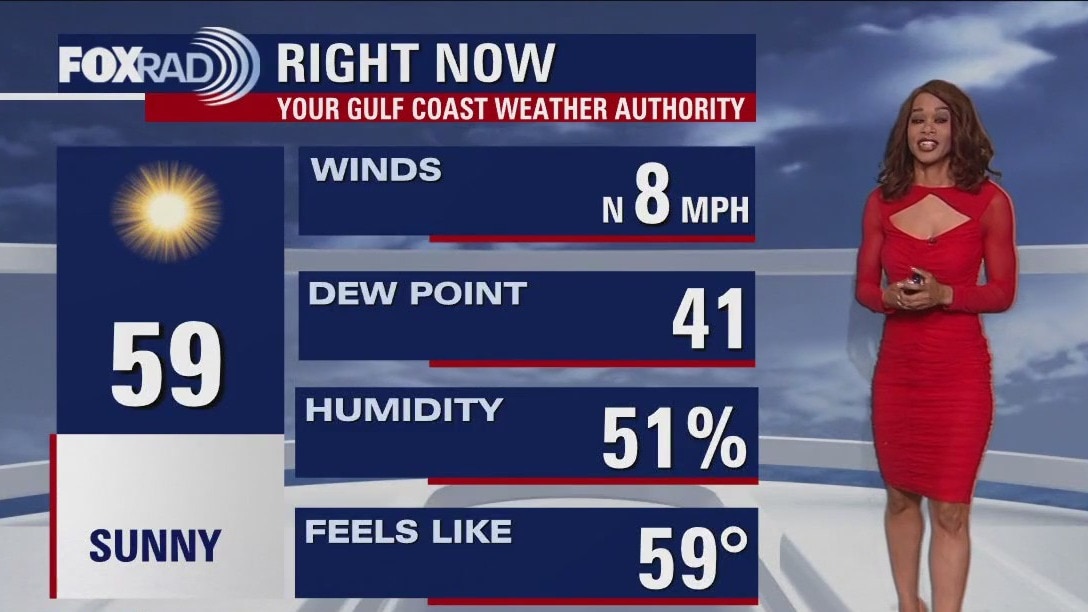
Sunny but chilly Friday evening in the 50s
Clouds have FINALLY rolled out of SE Texas allowing the sunshine to make an appearance. It will be a very chilly night with most spots near freezing but we should stay dry. Get ready for phenomenal outdoor weather for the weekend with lots of sunshine and temperatures gradually climbing to the 70s by Sunday. The next storm system will bring some showers Tuesday & Wednesday along with the chance for storms. So enjoy the break from the clouds and cold while you can and have a great weekend!
Clouds have FINALLY rolled out of SE Texas allowing the sunshine to make an appearance. It will be a very chilly night with most spots near freezing but we should stay dry. Get ready for phenomenal outdoor weather for the weekend with lots of sunshine and temperatures gradually climbing to the 70s by Sunday. The next storm system will bring some showers Tuesday & Wednesday along with the chance for storms. So enjoy the break from the clouds and cold while you can and have a great weekend!
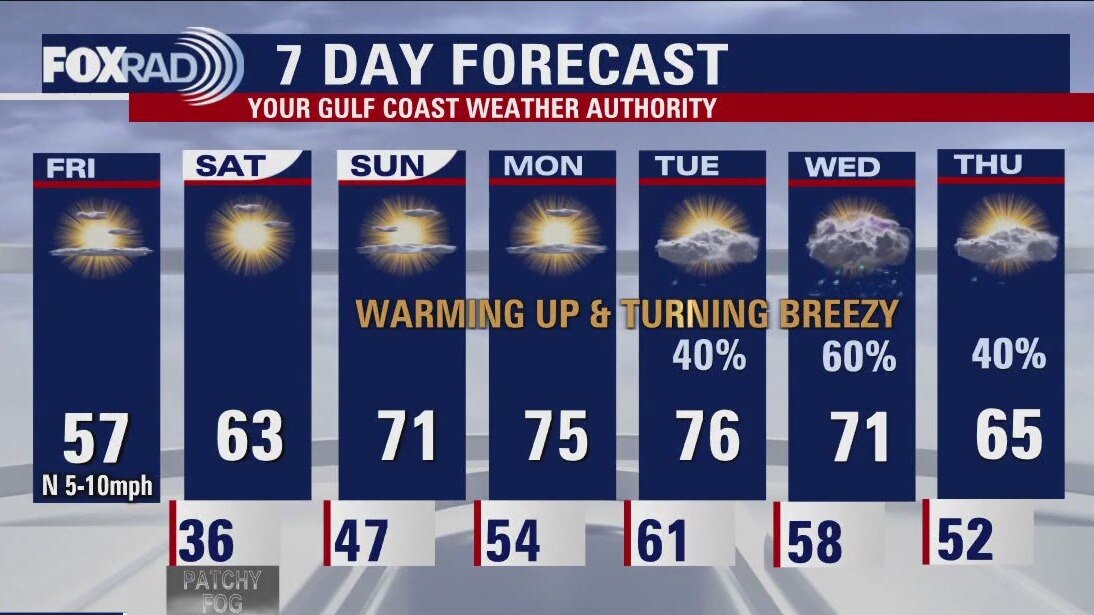
Friday weather forecast for Houston
Sunshine makes a roaring return to the forecast, with steadily improving temps each day. Tomorrow morning will be chilly again, with some outlying locations likely near the freezing mark and even a little bit of patchy freezing fog possible. Afternoons will be glorious with several 70+ days, the forecast turns breezy & unsettled toward the tail end of the 7-day.
Sunshine makes a roaring return to the forecast, with steadily improving temps each day. Tomorrow morning will be chilly again, with some outlying locations likely near the freezing mark and even a little bit of patchy freezing fog possible. Afternoons will be glorious with several 70+ days, the forecast turns breezy & unsettled toward the tail end of the 7-day.
Friday weather forecast for Houston
Cold and breezy this morning, then partly cloudy, cool and dry with highs in the mid 50s.
Cold and breezy this morning, then partly cloudy, cool and dry with highs in the mid 50s.
Friday morning Houston-area weather forecast
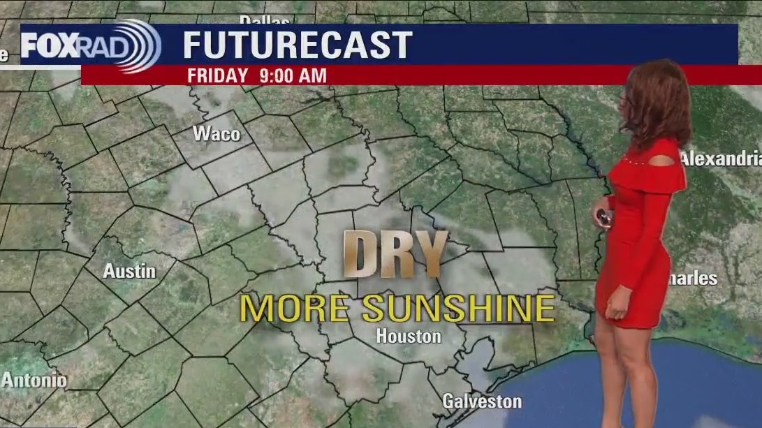
A change is coming! And we could sure use it after a cloudy, cold and at times wet week so far. Look for some clouds, fog and drizzle to stick around tonight with temperatures dipping to the middle to upper 30s. No ice is expect tonight. Plan on some icy roads still possible if your travels take you over towards Austin or up towards Dallas. Pattern shift kicks into high gear for SE Texas Friday through the weekend with sunshine and warmer temps. We should climb to near 60 by Friday afternoon with temperatures soaring to the low 70s by Sunday. Warmth will extend through the middle of next week with a chance for showers by Tuesday and Wednesday. Make plans outdoors for the weekend since Houston will have phenomenal weather!
A change is coming! And we could sure use it after a cloudy, cold and at times wet week so far. Look for some clouds, fog and drizzle to stick around tonight with temperatures dipping to the middle to upper 30s. No ice is expect tonight. Plan on some icy roads still possible if your travels take you over towards Austin or up towards Dallas. Pattern shift kicks into high gear for SE Texas Friday through the weekend with sunshine and warmer temps. We should climb to near 60 by Friday afternoon with temperatures soaring to the low 70s by Sunday. Warmth will extend through the middle of next week with a chance for showers by Tuesday and Wednesday. Make plans outdoors for the weekend since Houston will have phenomenal weather!
Chilly temps in the 40s Thursday evening
A change is coming! And we could sure use it after a cloudy, cold and at times wet week so far. Look for some clouds, fog and drizzle to stick around tonight with temperatures dipping to the middle to upper 30s. No ice is expect tonight. Plan on some icy roads still possible if your travels take you over towards Austin or up towards Dallas. Pattern shift kicks into high gear for SE Texas Friday through the weekend with sunshine and warmer temps. We should climb to near 60 by Friday afternoon with temperatures soaring to the low 70s by Sunday. Warmth will extend through the middle of next week with a chance for showers by Tuesday and Wednesday. Make plans outdoors for the weekend since Houston will have phenomenal weather!
A change is coming! And we could sure use it after a cloudy, cold and at times wet week so far. Look for some clouds, fog and drizzle to stick around tonight with temperatures dipping to the middle to upper 30s. No ice is expect tonight. Plan on some icy roads still possible if your travels take you over towards Austin or up towards Dallas. Pattern shift kicks into high gear for SE Texas Friday through the weekend with sunshine and warmer temps. We should climb to near 60 by Friday afternoon with temperatures soaring to the low 70s by Sunday. Warmth will extend through the middle of next week with a chance for showers by Tuesday and Wednesday. Make plans outdoors for the weekend since Houston will have phenomenal weather!
Chilly, cloudy Thursday afternoon in the 40s
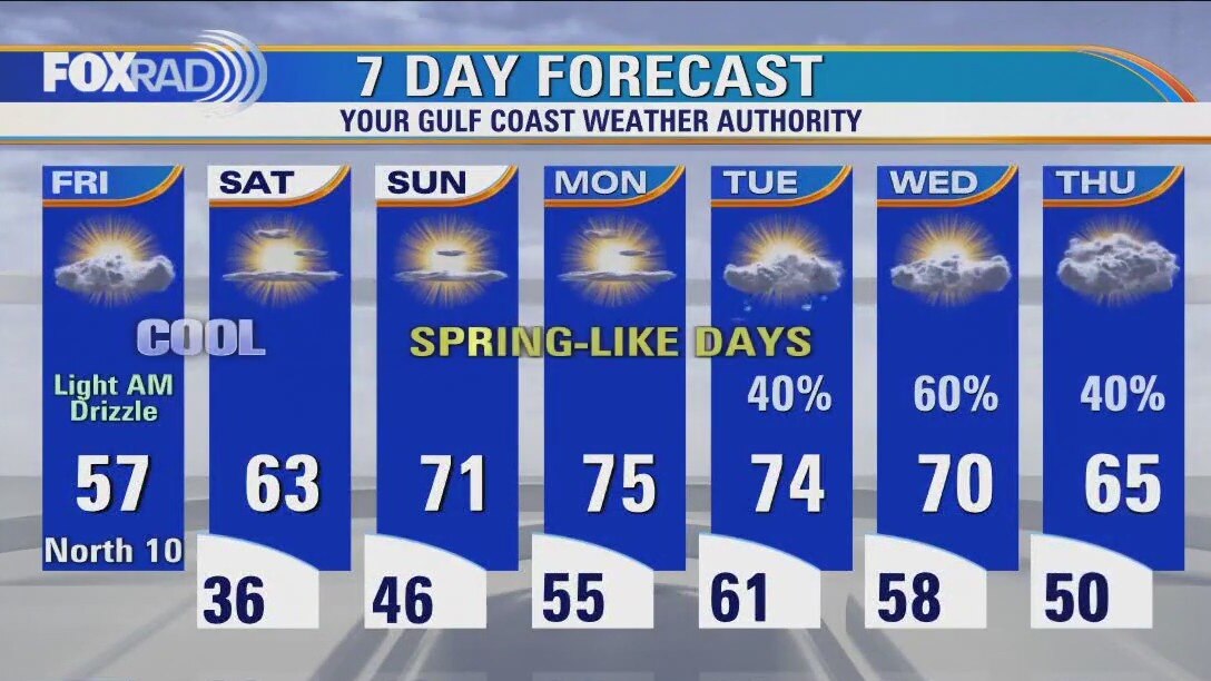
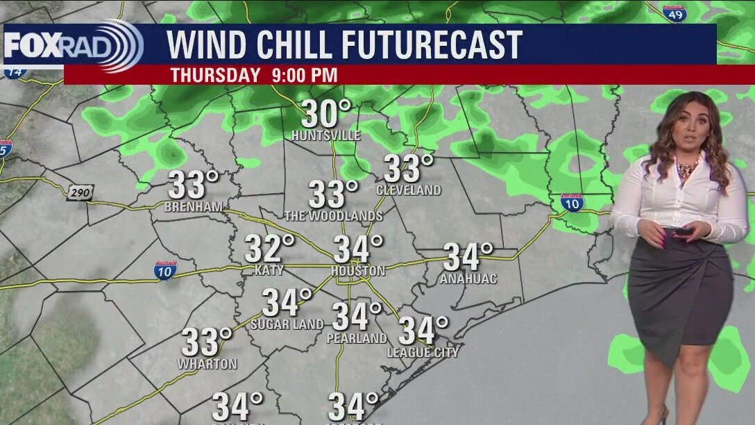
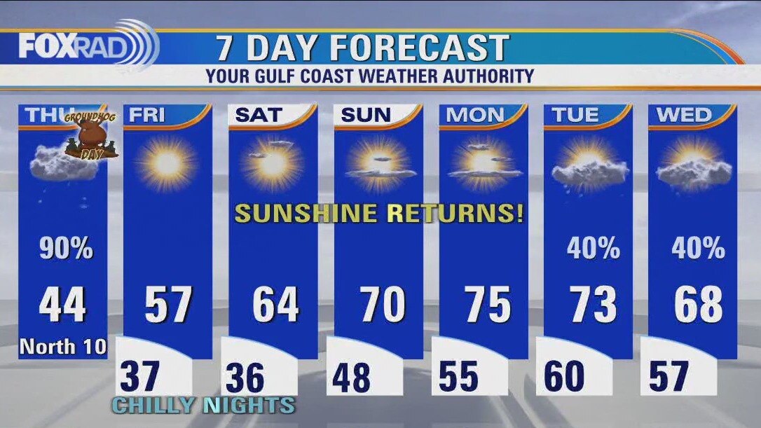
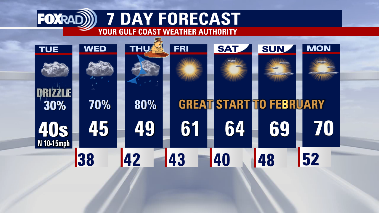
Get ready for improvements! Rain chances will continue to drop throughout the rest of today but we'll stay cloudy through tomorrow morning. Clouds decrease throughout the day Friday but chilly temps, especially in the mornings will linger. Wind chills could get down into the 20s in outlying areas Friday + Saturday mornings so layer up! Good news is, we can bask in the glory of several dry, sunny warmer days over the weekend and into the start of next week. Bad news is, the forecast looks to turn messy again starting on Tuesday.
Get ready for improvements! Rain chances will continue to drop throughout the rest of today but we'll stay cloudy through tomorrow morning. Clouds decrease throughout the day Friday but chilly temps, especially in the mornings will linger. Wind chills could get down into the 20s in outlying areas Friday + Saturday mornings so layer up! Good news is, we can bask in the glory of several dry, sunny warmer days over the weekend and into the start of next week. Bad news is, the forecast looks to turn messy again starting on Tuesday.
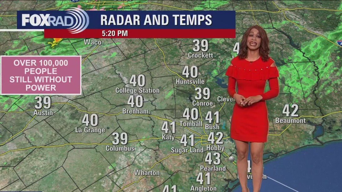
Houston weather: Cold and wet again on Thursday
Today will be cold and wet again, but we have much nicer weather on the way. Expect an overcast, showery day today with temperatures stuck in the low 40s for most of the day. Rain should move out of the area late this afternoon as we turn the corner toward a clear pattern Friday through Monday. This weekend is shaping up to be a beauty with sunny days bringing highs in the 60s on Saturday and low 70s on Sunday. Rain could return by Tuesday.
Today will be cold and wet again, but we have much nicer weather on the way. Expect an overcast, showery day today with temperatures stuck in the low 40s for most of the day. Rain should move out of the area late this afternoon as we turn the corner toward a clear pattern Friday through Monday. This weekend is shaping up to be a beauty with sunny days bringing highs in the 60s on Saturday and low 70s on Sunday. Rain could return by Tuesday.
Thursday morning Houston-area weather forecast
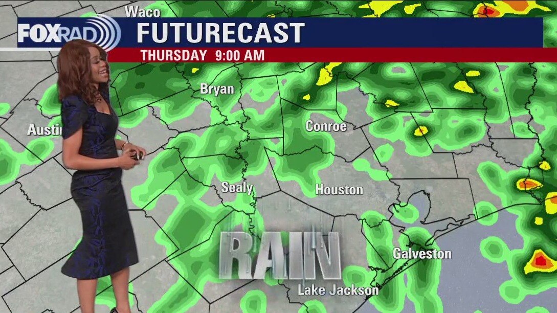
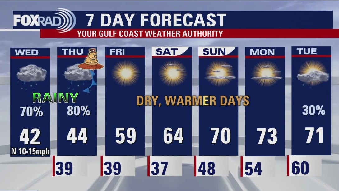
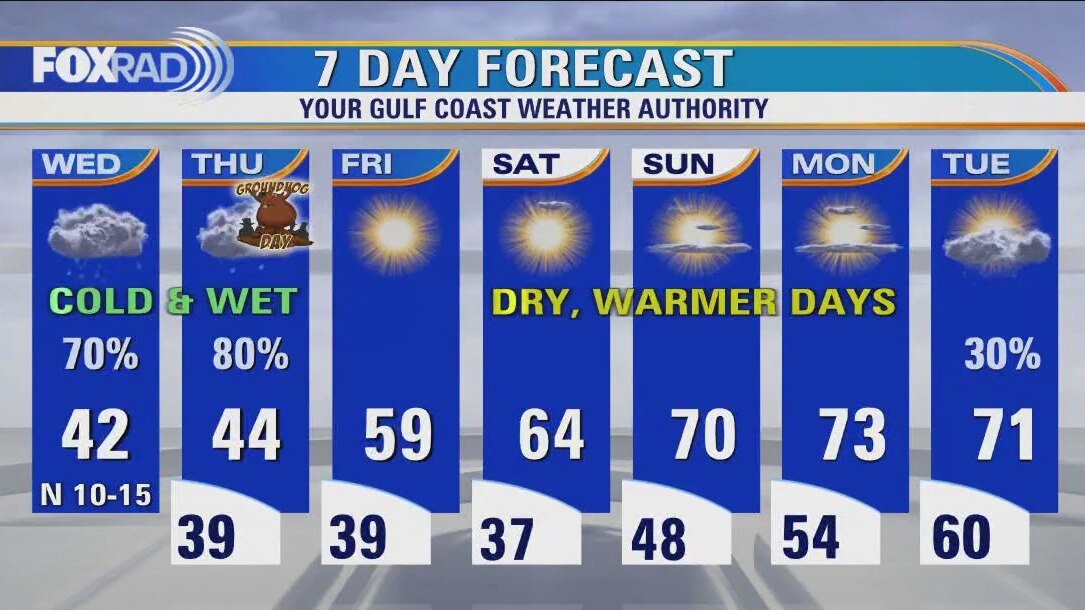
Isolated light icing is still possible NW of Houston up around Washington county where a Winter Weather Advisory has been extended until 6 AM Thursday. Major issues are not expected, but a few icy spots might develop on bridges, sidewalks, etc. Unseasonably cold air sticks around tonight and tomorrow with 30s tonight and 40s Thursday. Rounds of light to moderate rain will move through tonight through Thursday morning, tapering off during Thursday afternoon. There's a slim shot for some flooding issues to pop up especially in areas that have picked up several inches of rain recently. Pattern FINALLY starts to shift by Friday with drier air and more sunshine returning. Temps gradually heat up again with 70s expected by Sunday and Monday.
Isolated light icing is still possible NW of Houston up around Washington county where a Winter Weather Advisory has been extended until 6 AM Thursday. Major issues are not expected, but a few icy spots might develop on bridges, sidewalks, etc. Unseasonably cold air sticks around tonight and tomorrow with 30s tonight and 40s Thursday. Rounds of light to moderate rain will move through tonight through Thursday morning, tapering off during Thursday afternoon. There's a slim shot for some flooding issues to pop up especially in areas that have picked up several inches of rain recently. Pattern FINALLY starts to shift by Friday with drier air and more sunshine returning. Temps gradually heat up again with 70s expected by Sunday and Monday.

Wednesday evening weather forecast with Meteorologist Remeisha Shade
Isolated light icing is still possible NW of Houston up around Washington county where a Winter Weather Advisory has been extended until 6 AM Thursday. Major issues are not expected, but a few icy spots might develop on bridges, sidewalks, etc. Unseasonably cold air sticks around tonight and tomorrow with 30s tonight and 40s Thursday. Rounds of light to moderate rain will move through tonight through Thursday morning, tapering off during Thursday afternoon. There's a slim shot for some flooding issues to pop up, especially in areas that have picked up several inches of rain recently. Pattern FINALLY starts to shift by Friday with drier air and more sunshine returning. Temps gradually heat up again with the 70s expected by Sunday and Monday.
Isolated light icing is still possible NW of Houston up around Washington county where a Winter Weather Advisory has been extended until 6 AM Thursday. Major issues are not expected, but a few icy spots might develop on bridges, sidewalks, etc. Unseasonably cold air sticks around tonight and tomorrow with 30s tonight and 40s Thursday. Rounds of light to moderate rain will move through tonight through Thursday morning, tapering off during Thursday afternoon. There's a slim shot for some flooding issues to pop up, especially in areas that have picked up several inches of rain recently. Pattern FINALLY starts to shift by Friday with drier air and more sunshine returning. Temps gradually heat up again with the 70s expected by Sunday and Monday.
Wednesday afternoon weather forecast with Meteorologist John Dawson
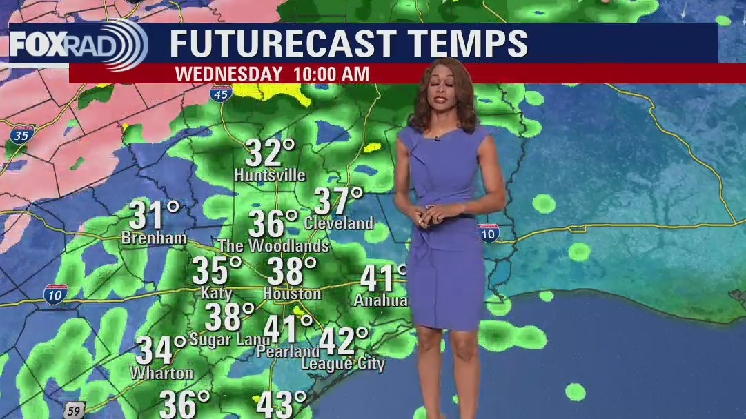
It's going to be a "near miss" for the Houston area for one more day with temperatures, fortunately, remaining above freezing here, but likely stuck near 40 degrees all day. Elsewhere in Texas, travel is at a standstill with dangerous ice covering roads in the north and central Texas. Watch for potential ice from Brenham westward and Huntsville northward. A few sleet pellets could mix in with rain today closer to Houston, but doesn't present a hazard. Expect off-and-on rain today, tonight, and tomorrow with improving conditions Friday through the weekend. In fact, sunshine and highs near 70 will return by Sunday.
It's going to be a "near miss" for the Houston area for one more day with temperatures, fortunately, remaining above freezing here, but likely stuck near 40 degrees all day. Elsewhere in Texas, travel is at a standstill with dangerous ice covering roads in the north and central Texas. Watch for potential ice from Brenham westward and Huntsville northward. A few sleet pellets could mix in with rain today closer to Houston, but doesn't present a hazard. Expect off-and-on rain today, tonight, and tomorrow with improving conditions Friday through the weekend. In fact, sunshine and highs near 70 will return by Sunday.
Houston forecast: Cold, misty and rainy at times on Wednesday
It's going to be a "near miss" for the Houston area for one more day with temperatures fortunately remaining above freezing here, but likely stuck near 40 degrees all day. Elsewhere in Texas, travel is at a standstill with dangerous ice covering roads in north and central Texas. Watch for potential ice from Brenham westward and Huntsville northward. A few sleet pellets could mix in with rain today closer to Houston, but doesn't present a hazard. Expect off and on rain today, tonight and tomorrow with improving conditions Friday through the weekend. In fact, sunshine and highs near 70 will return by Sunday.
It's going to be a "near miss" for the Houston area for one more day with temperatures fortunately remaining above freezing here, but likely stuck near 40 degrees all day. Elsewhere in Texas, travel is at a standstill with dangerous ice covering roads in north and central Texas. Watch for potential ice from Brenham westward and Huntsville northward. A few sleet pellets could mix in with rain today closer to Houston, but doesn't present a hazard. Expect off and on rain today, tonight and tomorrow with improving conditions Friday through the weekend. In fact, sunshine and highs near 70 will return by Sunday.
Wednesday morning Houston-area weather forecast
Winter Storm Warning is in effect for Washington county until Noon Wednesday which includes Brenham. Winter Weather Advisory is in place until Noon Wednesday for Walker, Grimes, Waller, Austin & Colorado counties. Expect the chance for a light glaze of ice tonight through Wednesday morning just NW of Houston. Precipitation should be mainly rain for the Houston area. Temperatures will stay chilly the next few days with lows in the 30s and highs in the 40s. Pattern does another major shift heading into the weekend with warmer, brighter & drier weather expected. Enjoy the rest of your week and make sure to download the FOX 26 weather app!
Winter Storm Warning is in effect for Washington county until Noon Wednesday which includes Brenham. Winter Weather Advisory is in place until Noon Wednesday for Walker, Grimes, Waller, Austin & Colorado counties. Expect the chance for a light glaze of ice tonight through Wednesday morning just NW of Houston. Precipitation should be mainly rain for the Houston area. Temperatures will stay chilly the next few days with lows in the 30s and highs in the 40s. Pattern does another major shift heading into the weekend with warmer, brighter & drier weather expected. Enjoy the rest of your week and make sure to download the FOX 26 weather app!

Tuesday evening weather forecast with Meteorologist Remeisha Shade
Winter Storm Warning is in effect for Washington county until Noon Wednesday which includes Brenham. Winter Weather Advisory is in place until Noon Wednesday for Walker, Grimes, Waller, and Austin & Colorado counties. Expect the chance for a light glaze of ice tonight through Wednesday morning just NW of Houston. Precipitation should be mainly rain for the Houston area. Temperatures will stay chilly for the next few days with lows in the 30s and highs in the 40s. The pattern does another major shift heading into the weekend with warmer, brighter & drier weather expected. Enjoy the rest of your week and make sure to download the FOX 26 weather app!
Winter Storm Warning is in effect for Washington county until Noon Wednesday which includes Brenham. Winter Weather Advisory is in place until Noon Wednesday for Walker, Grimes, Waller, and Austin & Colorado counties. Expect the chance for a light glaze of ice tonight through Wednesday morning just NW of Houston. Precipitation should be mainly rain for the Houston area. Temperatures will stay chilly for the next few days with lows in the 30s and highs in the 40s. The pattern does another major shift heading into the weekend with warmer, brighter & drier weather expected. Enjoy the rest of your week and make sure to download the FOX 26 weather app!
Tuesday afternoon weather forecast with Meteorologist John Dawson
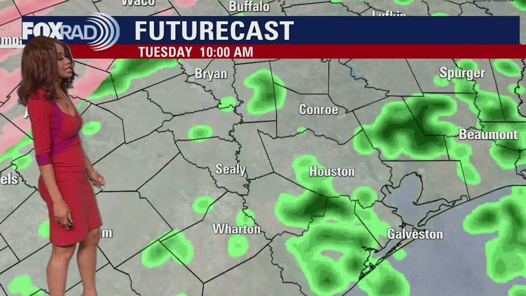
Brace yourself for a cold, blustery, and misty day with a chance for some light ice forming from Huntsville to Hempstead and surrounding areas through noon tomorrow. High temperatures may be stuck in the low 40s today and tomorrow with increasing chances for heavier rain by Wednesday and Thursday. Much of Texas including Dallas, Austin, and just about all of Central Texas icing over and travel will be treacherous and flights could be delayed. Sunshine and warmer days will arrive from Friday through this weekend.
Brace yourself for a cold, blustery, and misty day with a chance for some light ice forming from Huntsville to Hempstead and surrounding areas through noon tomorrow. High temperatures may be stuck in the low 40s today and tomorrow with increasing chances for heavier rain by Wednesday and Thursday. Much of Texas including Dallas, Austin, and just about all of Central Texas icing over and travel will be treacherous and flights could be delayed. Sunshine and warmer days will arrive from Friday through this weekend.
Houston weather: Cloudy, cold Tuesday with light showers
Brace yourself for a cold, blustery and misty day with a chance for some light ice forming from Huntsville to Hempstead and surrounding areas through noon tomorrow. High temperatures may be stuck in the low 40s today and tomorrow with increasing chances for heavier rain by Wednesday and Thursday. Much of Texas including Dallas, Austin and just about all of Central Texas are icing over and travel will be treacherous and flights could be delayed. Sunshine and warmer days will arrive for Friday through this weekend.
Brace yourself for a cold, blustery and misty day with a chance for some light ice forming from Huntsville to Hempstead and surrounding areas through noon tomorrow. High temperatures may be stuck in the low 40s today and tomorrow with increasing chances for heavier rain by Wednesday and Thursday. Much of Texas including Dallas, Austin and just about all of Central Texas are icing over and travel will be treacherous and flights could be delayed. Sunshine and warmer days will arrive for Friday through this weekend.
Tuesday morning Houston-area weather forecast
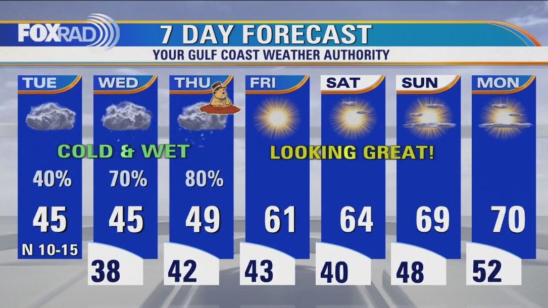
Winter weather has returned to SE Texas with around a 30 degree temperature drop since Sunday! Fog & a few light rain showers are possible tonight with a light glaze of ice also possible up in Washington county. So if you are around the Brenham area, prepare for the possibility of some slick roads in the morning, especially bridges & overpasses. Tuesday will be another cool day with some spotty light rain for much of the area. Temperatures will likely not get out of the 40s. Heading into Wednesday & Thursday, temperatures will remain cool but rain will get heavier as another system moves in. The flood threat will increase again since we've had so much rain recently. Fortunately, we dry out with more sun & milder temperatures expected for the weekend.
Winter weather has returned to SE Texas with around a 30 degree temperature drop since Sunday! Fog & a few light rain showers are possible tonight with a light glaze of ice also possible up in Washington county. So if you are around the Brenham area, prepare for the possibility of some slick roads in the morning, especially bridges & overpasses. Tuesday will be another cool day with some spotty light rain for much of the area. Temperatures will likely not get out of the 40s. Heading into Wednesday & Thursday, temperatures will remain cool but rain will get heavier as another system moves in. The flood threat will increase again since we've had so much rain recently. Fortunately, we dry out with more sun & milder temperatures expected for the weekend.

Monday evening weather forecast with Meteorologist Remeisha Shade
Winter weather has returned to SE Texas with around a 30-degree temperature drop since Sunday! Fog & a few light rain showers are possible tonight with a light glaze of ice also possible up in Washington county. So if you are around the Brenham area, prepare for the possibility of some slick roads in the morning, especially bridges & overpasses. Tuesday will be another cool day with some spotty light rain for much of the area. Temperatures will likely not get out of the 40s. Heading into Wednesday & Thursday, temperatures will remain cool but rain will get heavier as another system moves in. The flood threat will increase again since we've had so much rain recently. Fortunately, we dry out with more sun & milder temperatures expected for the weekend.
Winter weather has returned to SE Texas with around a 30-degree temperature drop since Sunday! Fog & a few light rain showers are possible tonight with a light glaze of ice also possible up in Washington county. So if you are around the Brenham area, prepare for the possibility of some slick roads in the morning, especially bridges & overpasses. Tuesday will be another cool day with some spotty light rain for much of the area. Temperatures will likely not get out of the 40s. Heading into Wednesday & Thursday, temperatures will remain cool but rain will get heavier as another system moves in. The flood threat will increase again since we've had so much rain recently. Fortunately, we dry out with more sun & milder temperatures expected for the weekend.
Houston weather: Cloudy & cold Monday with areas of drizzle
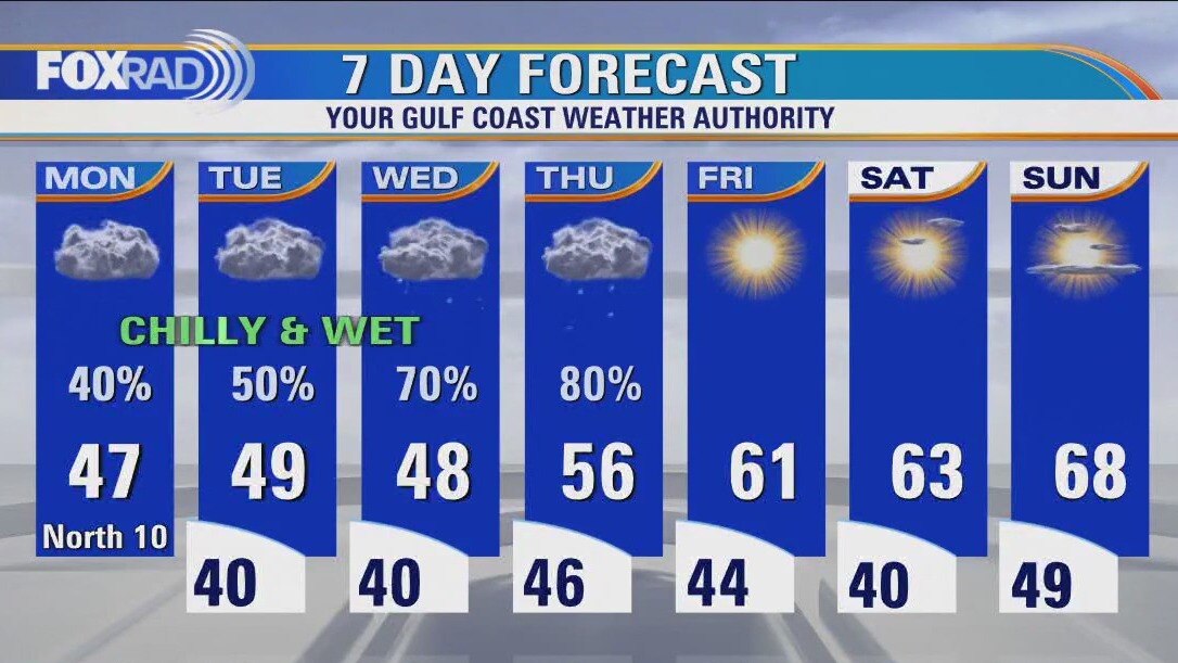
We are stuck in a cold, cloudy and wet pattern through Thursday. Temperatures is most areas inland will remain in the 40s and low 50s each day and overnight lows will reach the upper 30s and low 40s along with rounds of showers. Areas well north and west of Houston closer to College Station, Austin and Dallas will have a risk for freezing rain and sleet that may cause major travel issues. Watch for heavy rain locally on Wednesday and Thursday followed by the return of Sunshine and dry air Friday through the weekend.
We are stuck in a cold, cloudy and wet pattern through Thursday. Temperatures is most areas inland will remain in the 40s and low 50s each day and overnight lows will reach the upper 30s and low 40s along with rounds of showers. Areas well north and west of Houston closer to College Station, Austin and Dallas will have a risk for freezing rain and sleet that may cause major travel issues. Watch for heavy rain locally on Wednesday and Thursday followed by the return of Sunshine and dry air Friday through the weekend.
Monday morning Houston-area weather forecast
The cold front that brought showers and downpours on Sunday stalled along the coast and will keep rain in the forecast for the start of the work week. Monday looks dreary and cool as colder air continues to move into Southeast Texas. Another front arrives on Thursday with the possibility of stronger storms when it arrives to Houston.
The cold front that brought showers and downpours on Sunday stalled along the coast and will keep rain in the forecast for the start of the work week. Monday looks dreary and cool as colder air continues to move into Southeast Texas. Another front arrives on Thursday with the possibility of stronger storms when it arrives to Houston.