

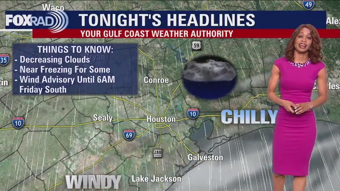
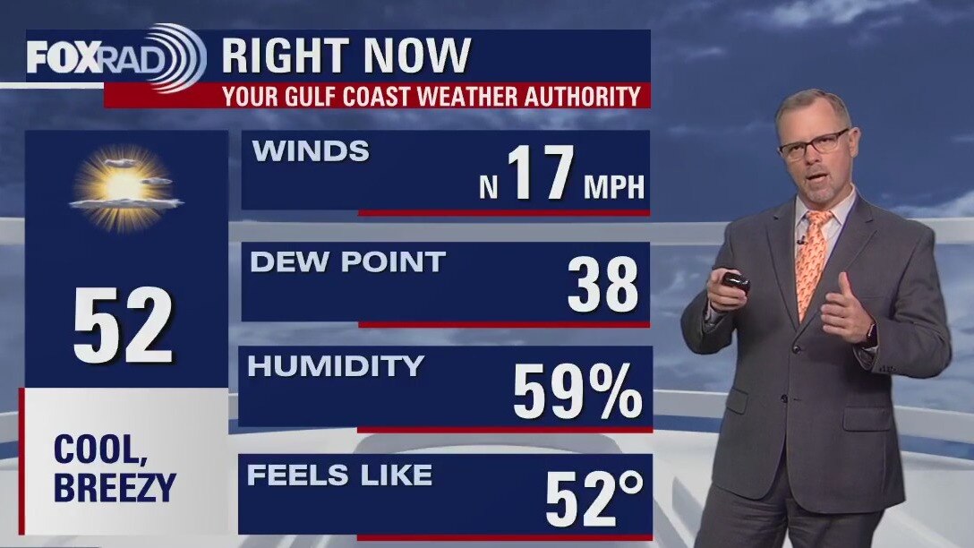
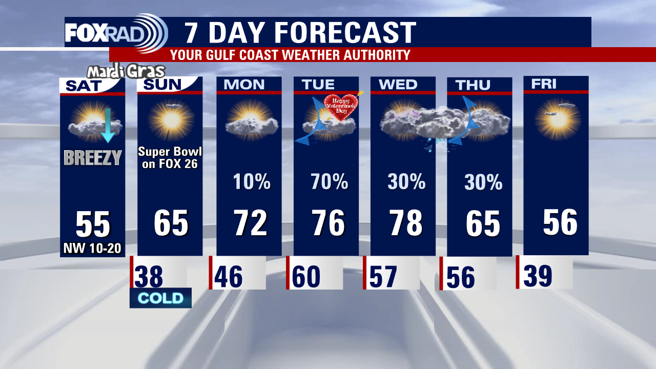
Windy, chilly Thursday evening in the 50s
Cold front rolled across the area this morning bringing a quick round of rain & a few rumbles of thunder. Behind the front, windy & much colder conditions are building in with gusts 30-40 mph possible near the coast. That is where a WIND ADVISORY is now in place until 6 AM Friday. Make sure to secure any loose/light objects around your house. Bundle up too because much colder air is filtering in for the next few nights. Temperatures will drop to the 30s tonight and Friday night with highs only in the 50s Friday and Saturday. Look for a BIG jump in temps for the second half of the weekend as we soar to the 70s! Weather all weekend for Galveston Mardi Gras and any other outdoor plans should be dry with only slim rain chances Monday - Wednesday next week.
Cold front rolled across the area this morning bringing a quick round of rain & a few rumbles of thunder. Behind the front, windy & much colder conditions are building in with gusts 30-40 mph possible near the coast. That is where a WIND ADVISORY is now in place until 6 AM Friday. Make sure to secure any loose/light objects around your house. Bundle up too because much colder air is filtering in for the next few nights. Temperatures will drop to the 30s tonight and Friday night with highs only in the 50s Friday and Saturday. Look for a BIG jump in temps for the second half of the weekend as we soar to the 70s! Weather all weekend for Galveston Mardi Gras and any other outdoor plans should be dry with only slim rain chances Monday - Wednesday next week.
Cloudy, cool Thursday afternoon in the 50s
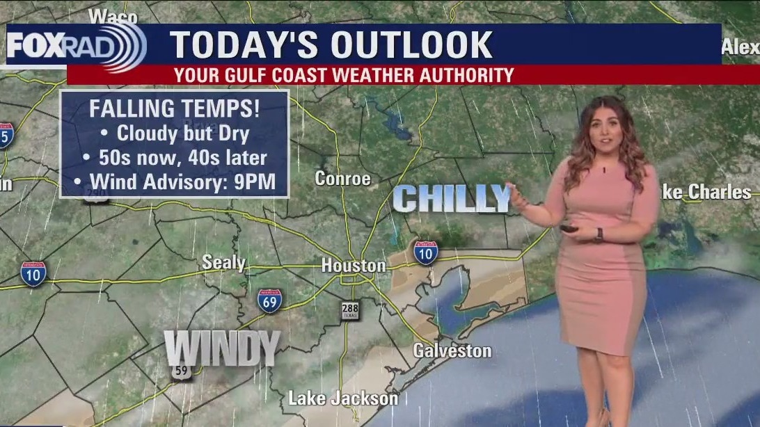
Gusty north winds will drive down temperatures for the rest of the day, with our highs having occurred this morning. We'll stay breezy through Friday night, with two chilly but dry days. Mardi Gras weekend 2 starts on the cool side and ends much warmer, with lighter winds. Then, get ready for some toasty trail rides! On Monday, we turn breezy and humid as Presidential warmth moves in.
Gusty north winds will drive down temperatures for the rest of the day, with our highs having occurred this morning. We'll stay breezy through Friday night, with two chilly but dry days. Mardi Gras weekend 2 starts on the cool side and ends much warmer, with lighter winds. Then, get ready for some toasty trail rides! On Monday, we turn breezy and humid as Presidential warmth moves in.
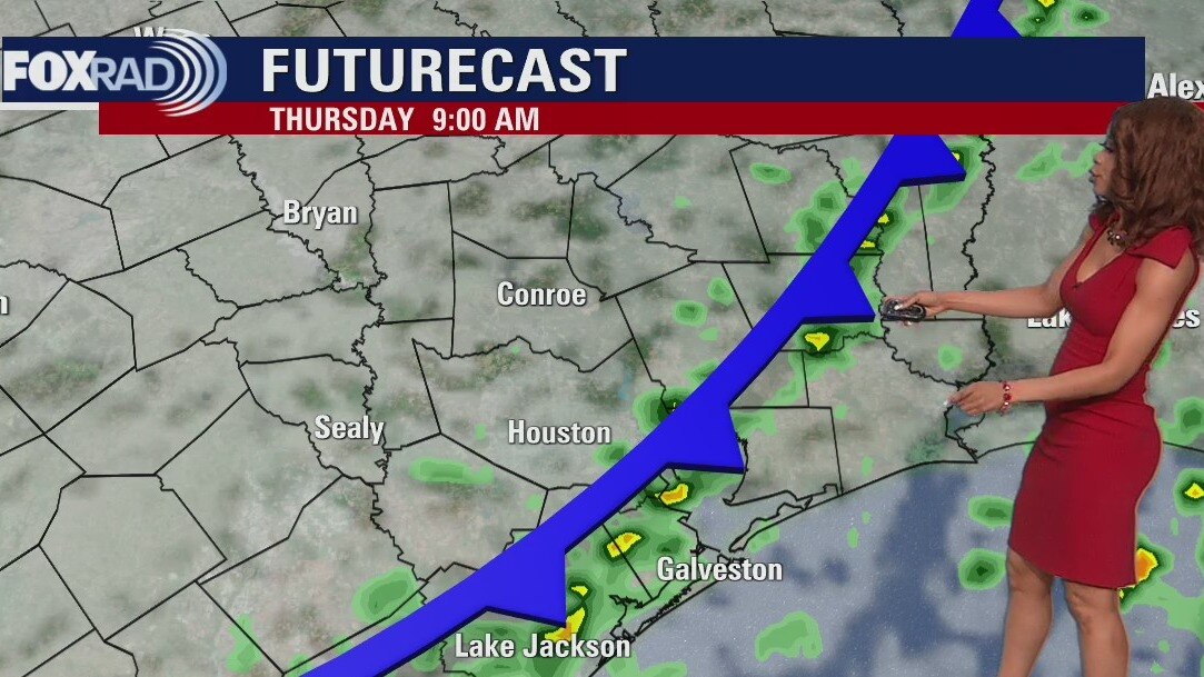
Houston weather: Some Thursday morning showers, then falling temperatures
Today will end much cooler than it's starting, with a few showers early on followed by windy conditions. We'll stay breezy through Friday night, with two chilly but dry days. Mardi Gras weekend 2 starts on the cool side and ends much warmer, with lighter winds. Then, get ready for some steamy trail rides! On Monday, we turn breezy and humid as Presidential warmth moves in.
Today will end much cooler than it's starting, with a few showers early on followed by windy conditions. We'll stay breezy through Friday night, with two chilly but dry days. Mardi Gras weekend 2 starts on the cool side and ends much warmer, with lighter winds. Then, get ready for some steamy trail rides! On Monday, we turn breezy and humid as Presidential warmth moves in.
Thursday morning Houston-area weather forecast
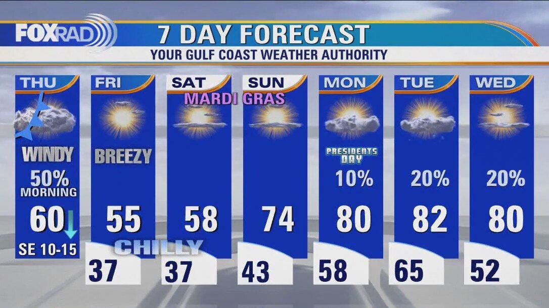
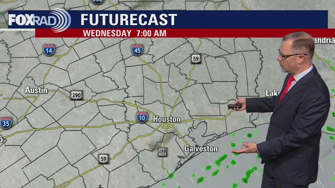
Big pattern change is on the way...again! We stay mild and breezy early tonight with a strong cold front rolling in Thursday morning. That front will bring in a quick round of rain & a slim shot at an isolated strong/severe storm. Best chance for any severe weather will be from 3-9 AM Thursday & just NE of Houston. Few storms may contain strong wind gusts and heavy rain. Threat is very limited in our area though. Rain totals should be around an inch or less for most of the area. We will all feel the temperatures dropping throughout the day on Thursday from near 60 early to 40s by evening. By Friday morning, we will dive into the 30s. Weekend weather looks much cooler but dry for Mardi Gras plans. Another heat wave and small rain chances return next week for President's Day.
Big pattern change is on the way...again! We stay mild and breezy early tonight with a strong cold front rolling in Thursday morning. That front will bring in a quick round of rain & a slim shot at an isolated strong/severe storm. Best chance for any severe weather will be from 3-9 AM Thursday & just NE of Houston. Few storms may contain strong wind gusts and heavy rain. Threat is very limited in our area though. Rain totals should be around an inch or less for most of the area. We will all feel the temperatures dropping throughout the day on Thursday from near 60 early to 40s by evening. By Friday morning, we will dive into the 30s. Weekend weather looks much cooler but dry for Mardi Gras plans. Another heat wave and small rain chances return next week for President's Day.

Wednesday evening weather fforecast with Meteorologist Remeisha Shade
A big pattern change is on the way...again! We stay mild and breezy early tonight with a strong cold front rolling in Thursday morning. That front will bring in a quick round of rain & a slim shot at an isolated strong/severe storm. The best chance for any severe weather will be from 3-9 AM Thursday & just NE of Houston. Few storms may contain strong wind gusts and heavy rain. The threat is very limited in our area though. Rain totals should be around an inch or less for most of the area. We will all feel the temperatures dropping throughout the day on Thursday from near 60 early to the 40s by evening. By Friday morning, we will dive into the 30s. Weekend weather looks much cooler but dry for Mardi Gras plans. Another heat wave and small rain chances return next week for President's Day.
A big pattern change is on the way...again! We stay mild and breezy early tonight with a strong cold front rolling in Thursday morning. That front will bring in a quick round of rain & a slim shot at an isolated strong/severe storm. The best chance for any severe weather will be from 3-9 AM Thursday & just NE of Houston. Few storms may contain strong wind gusts and heavy rain. The threat is very limited in our area though. Rain totals should be around an inch or less for most of the area. We will all feel the temperatures dropping throughout the day on Thursday from near 60 early to the 40s by evening. By Friday morning, we will dive into the 30s. Weekend weather looks much cooler but dry for Mardi Gras plans. Another heat wave and small rain chances return next week for President's Day.
Wednesday afternoon weather forecast with Meteorologist John Dawson
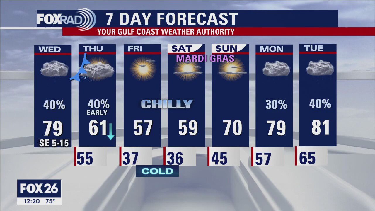
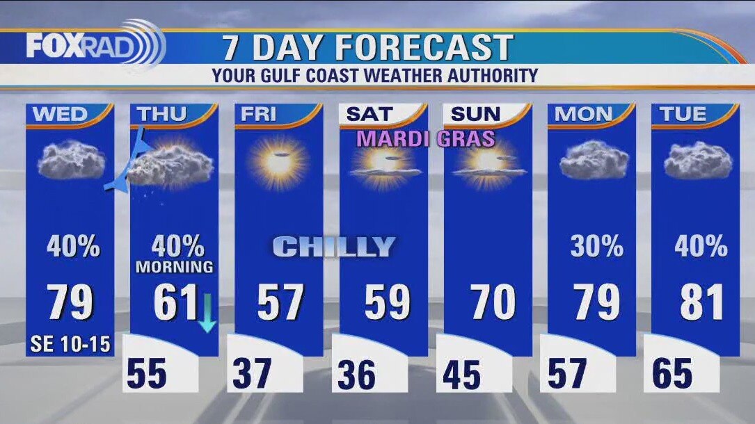
Get ready for some big changes that will arrive early tomorrow in the form of a strong cold front. Today will be cloudy, drizzly, breezy, and warm with a few storms possible. Watch for early morning rain on Thursday followed by chilly breezes and temperatures stuck in the 50s all day. Lows are likely to fall into the mid/upper 30s on Friday and Saturday morning.
Get ready for some big changes that will arrive early tomorrow in the form of a strong cold front. Today will be cloudy, drizzly, breezy, and warm with a few storms possible. Watch for early morning rain on Thursday followed by chilly breezes and temperatures stuck in the 50s all day. Lows are likely to fall into the mid/upper 30s on Friday and Saturday morning.
Houston weather: Cloudy and breezy Wednesday with highs in upper 70s
Get ready for some big changes that will arrive early tomorrow in the form of a strong cold front. Today will be cloudy, drizzly, breezy and warm with a few storms possible. Watch for early morning rain on Thursday followed by chilly breezes and temperatures stuck in the 50s all day. Lows are likely to fall into the mid/upper 30s on Friday and Saturday morning.
Get ready for some big changes that will arrive early tomorrow in the form of a strong cold front. Today will be cloudy, drizzly, breezy and warm with a few storms possible. Watch for early morning rain on Thursday followed by chilly breezes and temperatures stuck in the 50s all day. Lows are likely to fall into the mid/upper 30s on Friday and Saturday morning.
Wednesday morning Houston-area weather forecast
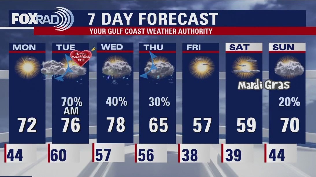
Look for a few showers around Southeast Texas on Wednesday ahead of the next cold front. That front reaches Houston early Thursday and brings a few showers and storms with it. Colder air moves in for Friday and Saturday with mornings back in the 30s. Isolated showers are possible for the holiday on Monday.
Look for a few showers around Southeast Texas on Wednesday ahead of the next cold front. That front reaches Houston early Thursday and brings a few showers and storms with it. Colder air moves in for Friday and Saturday with mornings back in the 30s. Isolated showers are possible for the holiday on Monday.

Valentine's Day evening weather forecast with Meteorologist John Dawson
Look for a few showers around Southeast Texas on Wednesday ahead of the next cold front. That front reaches Houston early Thursday and brings a few showers and storms with it. Colder air moves in for Friday and Saturday with mornings back in the 30s. Isolated showers are possible for the holiday on Monday.
Look for a few showers around Southeast Texas on Wednesday ahead of the next cold front. That front reaches Houston early Thursday and brings a few showers and storms with it. Colder air moves in for Friday and Saturday with mornings back in the 30s. Isolated showers are possible for the holiday on Monday.

Tuesday afternoon weather forecast with Meteorologist Mike Iscovitz
Scattered showers this morning will move eastward by the early afternoon leaving sunny, warm, and windy afternoon weather. This evening looks nice with dry weather and pleasant temps. Watch for patchy fog or drizzle on Wednesday and a cold front on early Thursday. Chilly air moves in late this week with lows in the 30s by Friday and Saturday morning.
Scattered showers this morning will move eastward by the early afternoon leaving sunny, warm, and windy afternoon weather. This evening looks nice with dry weather and pleasant temps. Watch for patchy fog or drizzle on Wednesday and a cold front on early Thursday. Chilly air moves in late this week with lows in the 30s by Friday and Saturday morning.
Houston weather: Scattered showers Tuesday morning, windy day
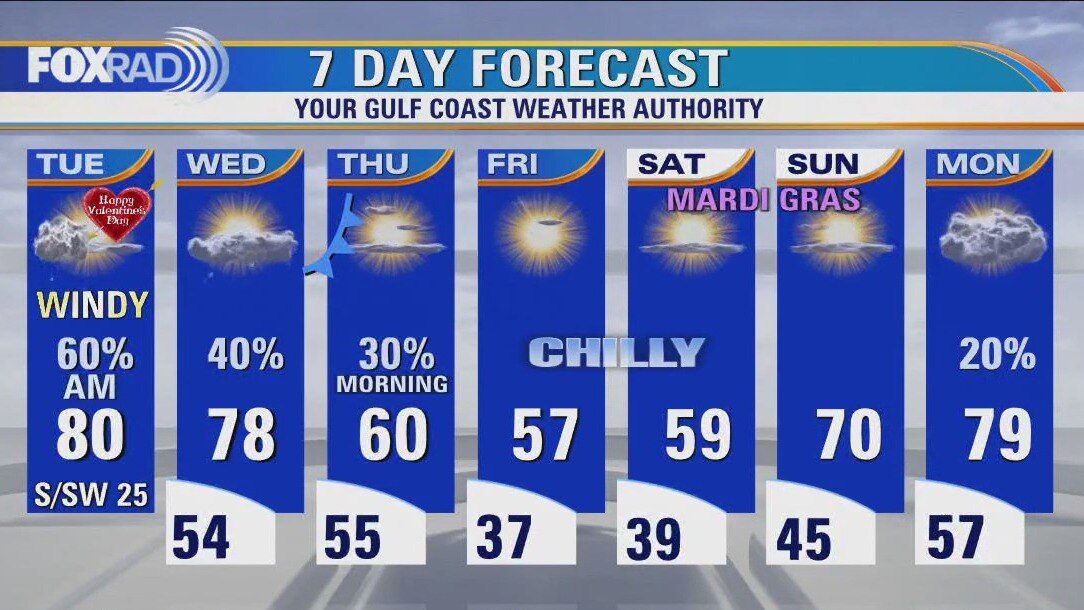
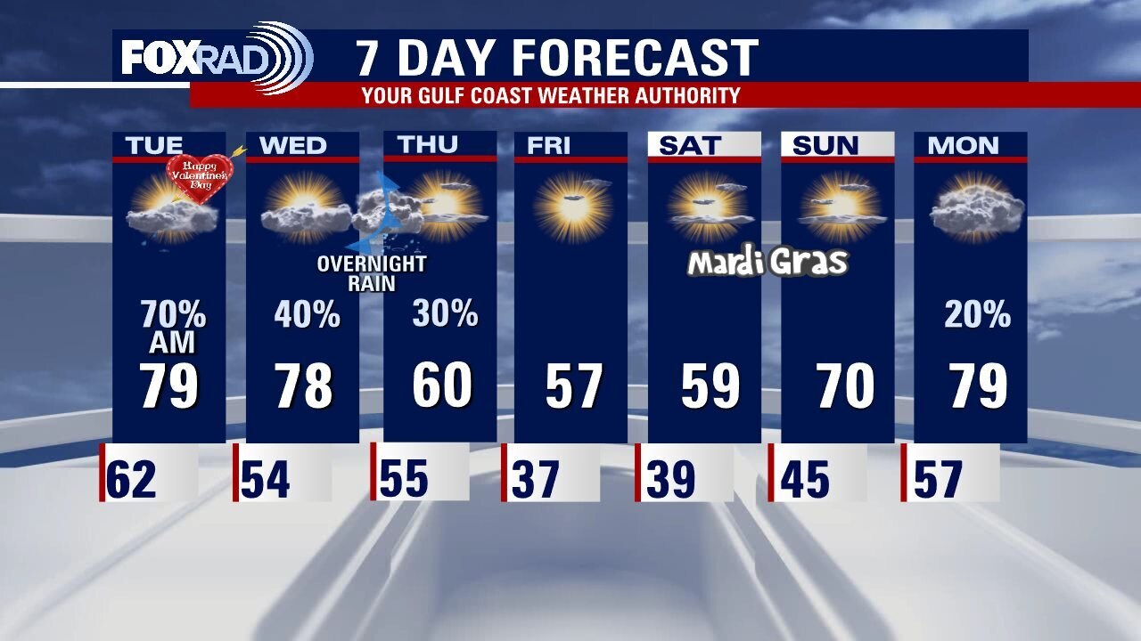
It's going to be a windy Valentine's Day with gusts above 30 mph throughout the day, especially after midday. Scattered showers this morning will move eastward by early afternoon leaving sunny, warm and windy afternoon weather. This evening looks nice with dry weather and pleasant temps. Watch for patchy fog or drizzle on Wednesday and a cold front early Thursday. Chilly air moves in late this week with lows in the 30s by Friday and Saturday morning.
It's going to be a windy Valentine's Day with gusts above 30 mph throughout the day, especially after midday. Scattered showers this morning will move eastward by early afternoon leaving sunny, warm and windy afternoon weather. This evening looks nice with dry weather and pleasant temps. Watch for patchy fog or drizzle on Wednesday and a cold front early Thursday. Chilly air moves in late this week with lows in the 30s by Friday and Saturday morning.
Monday evening weather forecast with Meteorologist John Dawson
Valentine's Day will not be a total washout, but there will certainly be some showers and isolated thunderstorms around Southeast Texas in the morning. A weak front will clear the skies in the afternoon but expect temperatures to remain warm, near 80 degrees. Another shot of rain is expected for Houston Wednesday night into early Thursday morning. Clear and cool conditions rolling into the holiday weekend.
Valentine's Day will not be a total washout, but there will certainly be some showers and isolated thunderstorms around Southeast Texas in the morning. A weak front will clear the skies in the afternoon but expect temperatures to remain warm, near 80 degrees. Another shot of rain is expected for Houston Wednesday night into early Thursday morning. Clear and cool conditions rolling into the holiday weekend.

Monday afternoon weather forecast with Chief Meteorologist Mike Iscovitz
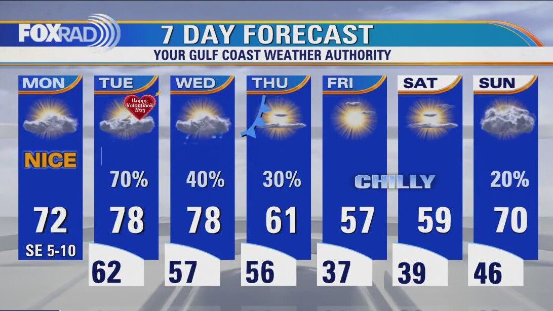
We're off to a nice, quiet start to the week with mild weather today and slightly warmer temperatures this afternoon. Valentine's Day should begin with rain and a brief round of storms that should be ending by early afternoon. Valentine's evening looks nice with temps in the 60s and 70s. Following another cold front scheduled for Wednesday night into Thursday morning, look for a cold end to the week with lows in the 30s on Friday and Saturday morning.
We're off to a nice, quiet start to the week with mild weather today and slightly warmer temperatures this afternoon. Valentine's Day should begin with rain and a brief round of storms that should be ending by early afternoon. Valentine's evening looks nice with temps in the 60s and 70s. Following another cold front scheduled for Wednesday night into Thursday morning, look for a cold end to the week with lows in the 30s on Friday and Saturday morning.
Houston weather: Clear and chilly Monday morning, then partly cloudy and pleasant
We're off to a nice, quiet start to the week with mild weather today and slightly warmer temperatures this afternoon. Valentine's Day should begin with rain and a brief round of storms that should be ending by early afternoon. Valentine's evening looks nice with temps in the 60s and 70s. Following another cold front scheduled for Wednesday night into Thursday morning, look for a cold end to the week with lows in the 30s on Friday and Saturday morning.
We're off to a nice, quiet start to the week with mild weather today and slightly warmer temperatures this afternoon. Valentine's Day should begin with rain and a brief round of storms that should be ending by early afternoon. Valentine's evening looks nice with temps in the 60s and 70s. Following another cold front scheduled for Wednesday night into Thursday morning, look for a cold end to the week with lows in the 30s on Friday and Saturday morning.
Sunday evening/Saturday morning weather forecast
Mild Monday across Southeast Texas with increasing humidity. Look for showers and storms to move into Houston early Tuesday morning as a front stalls along the coast. The stalled front keeps rain in the forecast for Wednesday and Thursday until another front clears the skies. That second front will also deliver a couple of chilly mornings at the end of the week.
Mild Monday across Southeast Texas with increasing humidity. Look for showers and storms to move into Houston early Tuesday morning as a front stalls along the coast. The stalled front keeps rain in the forecast for Wednesday and Thursday until another front clears the skies. That second front will also deliver a couple of chilly mornings at the end of the week.
Partly cloudy, warm Sunday evening in the 60s
Mild Monday across Southeast Texas with increasing humidity. Look for showers and storms to move into Houston early Tuesday morning as a front stalls along the coast. The stalled front keeps rain in the forecast for Wednesday and Thursday until another front clears the skies. That second front will also deliver a couple chilly mornings at the end of the week.
Mild Monday across Southeast Texas with increasing humidity. Look for showers and storms to move into Houston early Tuesday morning as a front stalls along the coast. The stalled front keeps rain in the forecast for Wednesday and Thursday until another front clears the skies. That second front will also deliver a couple chilly mornings at the end of the week.

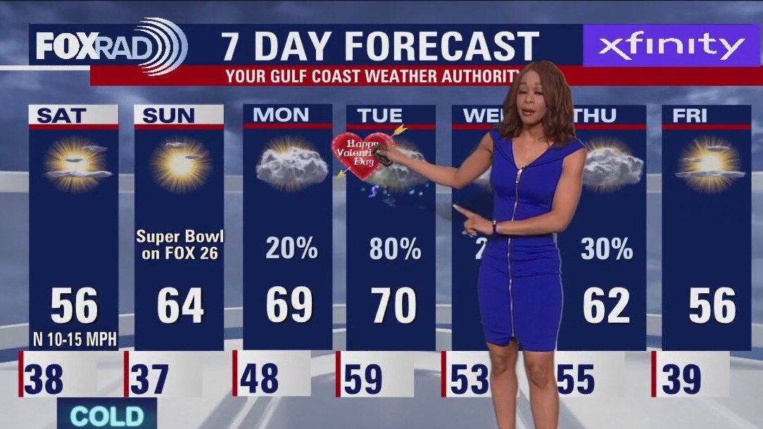
Super Bowl Sunday Weather Forecast with Meteorologist Lena Maria Arango
Super Bowl Sunday features a winning forecast in southeast Texas, then the humidity will be on the rise through midweek. A weak front brings in some Valentine's Day showers, mostly in the morning and after stalling/returning as a warm front keeps us breezy and unsettled until front #2 arrives. That second front will pose a severe weather threat to much of the deep south outside of our viewing area. For us, it'll lead to a chilly but bright second weekend of Mardi Gras.
Super Bowl Sunday features a winning forecast in southeast Texas, then the humidity will be on the rise through midweek. A weak front brings in some Valentine's Day showers, mostly in the morning and after stalling/returning as a warm front keeps us breezy and unsettled until front #2 arrives. That second front will pose a severe weather threat to much of the deep south outside of our viewing area. For us, it'll lead to a chilly but bright second weekend of Mardi Gras.
Chilly, breezy Saturday evening in the 50s
Houston will end the weekend with pleasant weather for a Super Bowl Sunday. Lots of sunshine with light winds follows a chilly morning. Monday will see the temperatures return to the 70 before a front arrives early Tuesday morning bringing showers and storms back to the forecast for Southeast Texas.
Houston will end the weekend with pleasant weather for a Super Bowl Sunday. Lots of sunshine with light winds follows a chilly morning. Monday will see the temperatures return to the 70 before a front arrives early Tuesday morning bringing showers and storms back to the forecast for Southeast Texas.
Saturday weather forecast with Meteorologist Lena Maria Arango
After a chilly and breezy Saturday with decreasing clouds, high pressure builds overhead for Superbowl Sunday. It'll still be cold in the morning, but a much milder afternoon with good sunshine. The work week then turns humid, breezy, and unsettled as a cold front passes over us on Tuesday and then stalls. Valentine's day will have some showers to dodge, followed by a warm front lifting north on Wednesday. Then, another cold front brings in mostly overnight showers and storms on Thursday leading to a chilly, bright, and dry end to the work week.
After a chilly and breezy Saturday with decreasing clouds, high pressure builds overhead for Superbowl Sunday. It'll still be cold in the morning, but a much milder afternoon with good sunshine. The work week then turns humid, breezy, and unsettled as a cold front passes over us on Tuesday and then stalls. Valentine's day will have some showers to dodge, followed by a warm front lifting north on Wednesday. Then, another cold front brings in mostly overnight showers and storms on Thursday leading to a chilly, bright, and dry end to the work week.
Saturday morning Houston-area weather forecast
Temperatures inland, especially north of Houston could get close to freezing early Saturday morning. So protect any sensitive plants and crank up the heat a bit tonight if you are sensitive to the cold. Super Bowl Sunday looks pleasant by the afternoon with temps in the low 60s and dry weather for watch parties. Few showers will return Monday but a much better chance for widespread rain is back on Valentine's Day Tuesday. Have a great weekend and don't forget to download the FOX 26 weather app!
Temperatures inland, especially north of Houston could get close to freezing early Saturday morning. So protect any sensitive plants and crank up the heat a bit tonight if you are sensitive to the cold. Super Bowl Sunday looks pleasant by the afternoon with temps in the low 60s and dry weather for watch parties. Few showers will return Monday but a much better chance for widespread rain is back on Valentine's Day Tuesday. Have a great weekend and don't forget to download the FOX 26 weather app!