


Tuesday morning Houston-area weather forecast
Expect a milder morning on Tuesday with temperatures in the 50s compared to the 30s seen around Houston on Monday morning. The warming continues during the week with another front on Friday delivering some storms to Southeast Texas. The weekend looks mild with a few showers around the area.
Expect a milder morning on Tuesday with temperatures in the 50s compared to the 30s seen around Houston on Monday morning. The warming continues during the week with another front on Friday delivering some storms to Southeast Texas. The weekend looks mild with a few showers around the area.

Monday evening weather forecast with Meteorologist John Dawson
Expect a milder morning on Tuesday with temperatures in the 50s compared to the 30s seen around Houston on Monday morning. The warming continues during the week with another front on Friday delivering some storms to Southeast Texas. The weekend looks mild with a few showers around the area.
Expect a milder morning on Tuesday with temperatures in the 50s compared to the 30s seen around Houston on Monday morning. The warming continues during the week with another front on Friday delivering some storms to Southeast Texas. The weekend looks mild with a few showers around the area.

Monday afternoon weather forecast with Chief Meteorologist Mike Iscovitz
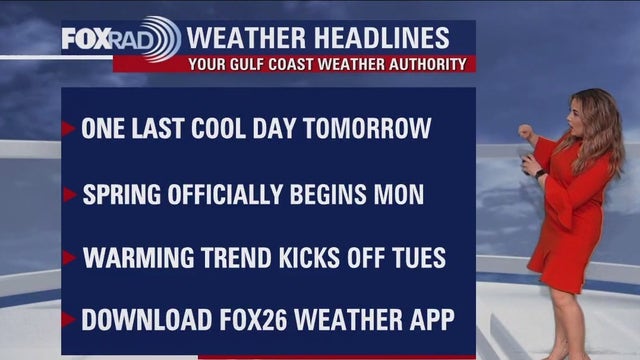
Spring begins at 4:24 p.m. today with the "vernal equinox" taking place, but it will still feel a but like winter today with temps running 15 degrees below average. A warming trend will begin tonight with the return of a southeast breeze, so look for 50s tonight, 70s tomorrow, then right back in the 80s by mid-week. Watch for a round of rain on Friday with severe weather possible, especially well north of Houston.
Spring begins at 4:24 p.m. today with the "vernal equinox" taking place, but it will still feel a but like winter today with temps running 15 degrees below average. A warming trend will begin tonight with the return of a southeast breeze, so look for 50s tonight, 70s tomorrow, then right back in the 80s by mid-week. Watch for a round of rain on Friday with severe weather possible, especially well north of Houston.

Houston weather: Cold Monday morning, warming into low 60s by afternoon
Spring begins at 4:24 p.m. today with the "vernal equinox" taking place, but it will still feel a bit like winter today with temps running 15 degrees below average. A warming trend will begin tonight with the return of a southeast breeze, so look for 50s tonight, 70s tomorrow, then right back in the 80s by mid-week. Watch for a round of rain on Friday with severe weather possible, especially well north of Houston.
Spring begins at 4:24 p.m. today with the "vernal equinox" taking place, but it will still feel a bit like winter today with temps running 15 degrees below average. A warming trend will begin tonight with the return of a southeast breeze, so look for 50s tonight, 70s tomorrow, then right back in the 80s by mid-week. Watch for a round of rain on Friday with severe weather possible, especially well north of Houston.

Sunday evening/Monday morning weather forecast
The official start of Spring in Houston will be chilly in the morning! Some of the FOX 26 area may even briefly see freezing temps. Milder conditions return to southeast Texas for the rest of the week.
The official start of Spring in Houston will be chilly in the morning! Some of the FOX 26 area may even briefly see freezing temps. Milder conditions return to southeast Texas for the rest of the week.

Cloudy, cold, and breezy Sunday evening in the 50s
The official start of Spring in Houston will be chilly in the morning! Some of the FOX 26 area may even briefly see freezing temps. Milder conditions return to southeast Texas for the rest of the week.
The official start of Spring in Houston will be chilly in the morning! Some of the FOX 26 area may even briefly see freezing temps. Milder conditions return to southeast Texas for the rest of the week.
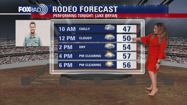

Luke Bryan performs at the final night of the Houston Rodeo; how will the temperatures look?
Last call for the Houston Livestock Show and Rodeo! Temperatures will be chilly once again, but we can look forward to more sunshine this afternoon!"
Last call for the Houston Livestock Show and Rodeo! Temperatures will be chilly once again, but we can look forward to more sunshine this afternoon!"

Winter season comes to an end; Spring starts Monday
It'll be chilly for the final day of the rodeo, but we should see a good amount of afternoon sunshine which will be a nice treat! Look out for a cold night, as many dip into the upper 30s for the bus stop hour tomorrow morning but otherwise, a quiet return to work and school locally. Spring begins and onshore flow returns, kicking off a warming trend through the end of the week. Rain chances in general are slim until Friday, which looks stormy as our next cold front pushes through.
It'll be chilly for the final day of the rodeo, but we should see a good amount of afternoon sunshine which will be a nice treat! Look out for a cold night, as many dip into the upper 30s for the bus stop hour tomorrow morning but otherwise, a quiet return to work and school locally. Spring begins and onshore flow returns, kicking off a warming trend through the end of the week. Rain chances in general are slim until Friday, which looks stormy as our next cold front pushes through.

Winter season comes to an end; Spring starts Monday
It'll be chilly for the final day of rodeo, but we should see a good amount of afternoon sunshine which will be a nice treat! Look out for a cold night, as many dip into the upper 30s for the bus stop hour tomorrow morning but otherwise, a quiet return to work and school locally. Spring begins and onshore flow returns, kicking off a warming trend through the end of the week. Rain chances in general are slim until Friday, which looks stormy as our next cold front pushes through.
It'll be chilly for the final day of rodeo, but we should see a good amount of afternoon sunshine which will be a nice treat! Look out for a cold night, as many dip into the upper 30s for the bus stop hour tomorrow morning but otherwise, a quiet return to work and school locally. Spring begins and onshore flow returns, kicking off a warming trend through the end of the week. Rain chances in general are slim until Friday, which looks stormy as our next cold front pushes through.

Sunday Morning Forecast with Meteorologist Lena Maria Arango
It'll be chilly for the final day of rodeo, but we should see a good amount of afternoon sunshine which will be a nice treat! Look out for a cold night, as many dip into the 30s for the bus stop hour tomorrow morning but otherwise, a quiet return to work and school locally. Spring begins and onshore flow returns, kicking off a warming trend through the end of the week. Rain chances in general are slim until Friday, which looks stormy as our next cold front pushes through.
It'll be chilly for the final day of rodeo, but we should see a good amount of afternoon sunshine which will be a nice treat! Look out for a cold night, as many dip into the 30s for the bus stop hour tomorrow morning but otherwise, a quiet return to work and school locally. Spring begins and onshore flow returns, kicking off a warming trend through the end of the week. Rain chances in general are slim until Friday, which looks stormy as our next cold front pushes through.


Houston Weather: Sleet falls in Houston Saturday; Your Gulf Coast Weather Authority explains how
Both the National Weather Service and viewers reported sleet pellets mixing in with cold rain on Saturday morning on the south side of town in Houston.
Both the National Weather Service and viewers reported sleet pellets mixing in with cold rain on Saturday morning on the south side of town in Houston.

Freezing Precipitation without Freezing Temperatures, Your Gulf Coast Weather Authority explains
Both the National Weather Service and viewers reported sleet pellets mixing in with a cold rain on Saturday morning on the south side of town in Houston.
Both the National Weather Service and viewers reported sleet pellets mixing in with a cold rain on Saturday morning on the south side of town in Houston.


Break out your jackets for the last weekend of the Houston Rodeo
It's the last weekend of the Houston Livestock Show and Rodeo, and Meteorologist Lena Maria Arango says the weather is finally giving us an opportunity to bust out our flannel and leather.
It's the last weekend of the Houston Livestock Show and Rodeo, and Meteorologist Lena Maria Arango says the weather is finally giving us an opportunity to bust out our flannel and leather.

Break out your jackets for the last weekend of the Houston Rodeo
"It's the last weekend of the Houston Livestock Show and Rodeo, and Meteorologist Lena Maria Arango says the weather is finally giving us an opportunity to bust out our flannel and leather!"
"It's the last weekend of the Houston Livestock Show and Rodeo, and Meteorologist Lena Maria Arango says the weather is finally giving us an opportunity to bust out our flannel and leather!"

Saturday morning Houston-area weather forecast
Strong cold front that moved through Friday morning will mean below normal temperatures through early next week. A weak disturbance will bring a 30% chance for showers Saturday, mainly during the morning and afternoon with high temperatures in the 50s. Sunday should be dry but still mostly cloudy and chilly with temperatures climbing to the 50s. It will be a cool start to Spring on Monday with temperatures 15-20 degrees below normal. Small rain chances will be in the forecast Monday through Wednesday with a warming trend. We bounce back to the 80s by Thursday ahead of our next cold front that should bring rain and a few storms Thursday and Friday. Have a great weekend!
Strong cold front that moved through Friday morning will mean below normal temperatures through early next week. A weak disturbance will bring a 30% chance for showers Saturday, mainly during the morning and afternoon with high temperatures in the 50s. Sunday should be dry but still mostly cloudy and chilly with temperatures climbing to the 50s. It will be a cool start to Spring on Monday with temperatures 15-20 degrees below normal. Small rain chances will be in the forecast Monday through Wednesday with a warming trend. We bounce back to the 80s by Thursday ahead of our next cold front that should bring rain and a few storms Thursday and Friday. Have a great weekend!

Cold, cloudy, breezy Friday afternoon in the 40s, 50s
The bulk of the rain we'll be receiving today has already occurred this morning, look for ending showers but gusty winds linger into tomorrow. Another round of light, scattered showers will be with us early Saturday and cold, cloudy days linger through Monday. You'll want layers for the last few days of Spring Break and the Rodeo! Middle of next week shows a gradual warming trend, possibly curtailed by another late week front.
The bulk of the rain we'll be receiving today has already occurred this morning, look for ending showers but gusty winds linger into tomorrow. Another round of light, scattered showers will be with us early Saturday and cold, cloudy days linger through Monday. You'll want layers for the last few days of Spring Break and the Rodeo! Middle of next week shows a gradual warming trend, possibly curtailed by another late week front.

Houston rodeo forecast for Friday
Storms are moving out but we hang onto a blanket of light-moderate rain through midday. This front drove in chilly air and cloudy skies that will linger through early next week. Overnight Sunday into Monday some inland locations may dip into the 30s, but should stay above freezing. Muggy, warm air returns by middle of next week, with our next front slated to boost rain chances late Thursday/early Friday.
Storms are moving out but we hang onto a blanket of light-moderate rain through midday. This front drove in chilly air and cloudy skies that will linger through early next week. Overnight Sunday into Monday some inland locations may dip into the 30s, but should stay above freezing. Muggy, warm air returns by middle of next week, with our next front slated to boost rain chances late Thursday/early Friday.

Houston weather: Chilly Friday with some rain through midday
Storms are moving out but we hang onto a blanket of light-moderate rain through midday. This front drove in chilly air and cloudy skies that will linger through early next week. Overnight Sunday into Monday some inland locations may dip into the 30s, but should stay above freezing. Muggy, warm air returns by middle of next week, with our next front slated to boost rain chances late Thursday/early Friday.
Storms are moving out but we hang onto a blanket of light-moderate rain through midday. This front drove in chilly air and cloudy skies that will linger through early next week. Overnight Sunday into Monday some inland locations may dip into the 30s, but should stay above freezing. Muggy, warm air returns by middle of next week, with our next front slated to boost rain chances late Thursday/early Friday.

Friday morning Houston-area weather forecast
Threat for severe weather will stick around through early Friday morning. Threat is lowest near the coast and higher farther inland. Strong wind gusts near 60 mph will be the main threat with any storms that reach severe levels with just a low tornado threat. Expect scattered storms through early evening, a bit of a break early tonight then a solid line of rain and storms overnight. The overnight storms will likely reach Brenham & Bryan/College Station around 10-11 pm, Houston around 1 am, and Galveston around 3-4 am. Frequent lightning and heavy rain could also pose some issues with widespread 1-2" totals expected with isolated higher amounts. As the cold front moves through, wind will really pick up with gusts near 40 mph. A WIND ADVISORY is in effect from 1-10 AM Friday. Remember to bring in or tie down lightweight/loose objects around your yard like your trash cans! Bands of rain will still move through Friday morning behind the main line of storms. Most of the rain should push out by lunchtime. Much cooler air builds in Friday with temperatures by evening down into the 40s with wind chills in the 30s! Get ready! Also, make sure to download the FOX 26 Weather App and turn the alerts on so that you'll be up to date!
Threat for severe weather will stick around through early Friday morning. Threat is lowest near the coast and higher farther inland. Strong wind gusts near 60 mph will be the main threat with any storms that reach severe levels with just a low tornado threat. Expect scattered storms through early evening, a bit of a break early tonight then a solid line of rain and storms overnight. The overnight storms will likely reach Brenham & Bryan/College Station around 10-11 pm, Houston around 1 am, and Galveston around 3-4 am. Frequent lightning and heavy rain could also pose some issues with widespread 1-2" totals expected with isolated higher amounts. As the cold front moves through, wind will really pick up with gusts near 40 mph. A WIND ADVISORY is in effect from 1-10 AM Friday. Remember to bring in or tie down lightweight/loose objects around your yard like your trash cans! Bands of rain will still move through Friday morning behind the main line of storms. Most of the rain should push out by lunchtime. Much cooler air builds in Friday with temperatures by evening down into the 40s with wind chills in the 30s! Get ready! Also, make sure to download the FOX 26 Weather App and turn the alerts on so that you'll be up to date!

Winds, some rain expected Thursday along with threat for severe weather
Threat for severe weather will stick around through early Friday morning. Threat is lowest near the coast and higher farther inland. Strong wind gusts near 60 mph will be the main threat with any storms that reach severe levels with just a low tornado threat. Expect scattered storms through early evening, a bit of a break early tonight then a solid line of rain and storms overnight. The overnight storms will likely reach Brenham & Bryan/College Station around 10-11 pm, Houston around 1 am, and Galveston around 3-4 am. Frequent lightning and heavy rain could also pose some issues with widespread 1-2" totals expected with isolated higher amounts. As the cold front moves through, wind will really pick up with gusts near 40 mph. A Wind Advisory is in effect from 1-10 AM Friday. Remember to bring in or tie down lightweight/loose objects around your yard like your trash cans! Bands of rain will still move through Friday morning behind the main line of storms. Most of the rain should push out by lunchtime. Much cooler air builds in Friday with temperatures by evening down into the 40s with wind chills in the 30s! Get ready! Also, make sure to download the FOX 26 Weather App and turn the alerts on so that you'll be up to date!
Threat for severe weather will stick around through early Friday morning. Threat is lowest near the coast and higher farther inland. Strong wind gusts near 60 mph will be the main threat with any storms that reach severe levels with just a low tornado threat. Expect scattered storms through early evening, a bit of a break early tonight then a solid line of rain and storms overnight. The overnight storms will likely reach Brenham & Bryan/College Station around 10-11 pm, Houston around 1 am, and Galveston around 3-4 am. Frequent lightning and heavy rain could also pose some issues with widespread 1-2" totals expected with isolated higher amounts. As the cold front moves through, wind will really pick up with gusts near 40 mph. A Wind Advisory is in effect from 1-10 AM Friday. Remember to bring in or tie down lightweight/loose objects around your yard like your trash cans! Bands of rain will still move through Friday morning behind the main line of storms. Most of the rain should push out by lunchtime. Much cooler air builds in Friday with temperatures by evening down into the 40s with wind chills in the 30s! Get ready! Also, make sure to download the FOX 26 Weather App and turn the alerts on so that you'll be up to date!