


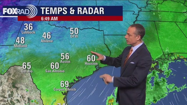
Houston-area weather: Isolated showers, storms possible on Wednesday, storm chances increase by the end of the week
Wednesday will be warm with only isolated showers and storms. Storms increase though Thursday PM and again Friday PM as a cold front moves in. Stay weather aware both days as we will be under the risk for a few severe storms with hail and damaging winds possible. Cold front moves through Friday night ushering in cooler and drier air for the weekend. Make your weekend plans outside now with pleasant temperatures, low humidity a good supply of sunshine expected.
Wednesday will be warm with only isolated showers and storms. Storms increase though Thursday PM and again Friday PM as a cold front moves in. Stay weather aware both days as we will be under the risk for a few severe storms with hail and damaging winds possible. Cold front moves through Friday night ushering in cooler and drier air for the weekend. Make your weekend plans outside now with pleasant temperatures, low humidity a good supply of sunshine expected.

Tuesday evening weather forecast with Meteorologist Remeisha Shade
After a decent round of showers and storms this morning, things are settling down somewhat for this evening. I can't rule out a stray shower or storm but coverage will be limited compared to what some of you saw this morning. It will be mild and breezy this evening with overnight lows dipping to the upper 60s in Houston. Wednesday will be warm with only isolated showers and storms. Storms increase through Thursday PM and again Friday PM as a cold front moves in. Stay weather aware both days as we will be at the risk of a few severe storms with hail and damaging winds possible. A cold front moves through Friday night ushering in cooler and drier air for the weekend. Make your weekend plans outside now with pleasant temperatures, low humidity a good supply of sunshine expected. Have a great night!
After a decent round of showers and storms this morning, things are settling down somewhat for this evening. I can't rule out a stray shower or storm but coverage will be limited compared to what some of you saw this morning. It will be mild and breezy this evening with overnight lows dipping to the upper 60s in Houston. Wednesday will be warm with only isolated showers and storms. Storms increase through Thursday PM and again Friday PM as a cold front moves in. Stay weather aware both days as we will be at the risk of a few severe storms with hail and damaging winds possible. A cold front moves through Friday night ushering in cooler and drier air for the weekend. Make your weekend plans outside now with pleasant temperatures, low humidity a good supply of sunshine expected. Have a great night!

Houston weather: Breezy Tuesday with isolated showers and a possible storm
After a round of early morning storms, today will become windy and mild with isolated showers and highs close to 80. Expect humidity to increase through the rest of the week with a good chance for storms from late Thursday through late Friday. If you or your family are going to the Taylor Swift show on Friday, don't get caught off-guard by storms that may be in the area. This weekend looks cool and mostly dry.
After a round of early morning storms, today will become windy and mild with isolated showers and highs close to 80. Expect humidity to increase through the rest of the week with a good chance for storms from late Thursday through late Friday. If you or your family are going to the Taylor Swift show on Friday, don't get caught off-guard by storms that may be in the area. This weekend looks cool and mostly dry.

Houston-area weather: Changes on the way, rain chances increasing
The weather the last few days has been exquisite with lower humidity, cooler temperatures and lots of sunshine. Some changes are on the way for the rest of the week as our winds shift from north to south and heat and humidity build. Hottest days will be Thursday and Friday as we soar into the middle 80s. Rain chances will be steadily increasing Tuesday through Thursday with the best chance for rain and storms with a cold front Friday afternoon and evening. That front will usher in another dose of cooler air just in time for the weekend.
The weather the last few days has been exquisite with lower humidity, cooler temperatures and lots of sunshine. Some changes are on the way for the rest of the week as our winds shift from north to south and heat and humidity build. Hottest days will be Thursday and Friday as we soar into the middle 80s. Rain chances will be steadily increasing Tuesday through Thursday with the best chance for rain and storms with a cold front Friday afternoon and evening. That front will usher in another dose of cooler air just in time for the weekend.

Monday evening weather forecast with Meteorologist Remeisha Shade
The weather over the last few days has been exquisite with lower humidity, cooler temperatures, and lots of sunshine. Some changes are on the way for the rest of the week as our winds shift from north to south and heat and humidity build. The hottest days will be Thursday and Friday as we soar into the middle 80s. Rain chances will be steadily increasing Tuesday through Thursday with the best chance for rain and storm with a cold front Friday afternoon and evening. That front will usher in another dose of cooler air just in time for the weekend.
The weather over the last few days has been exquisite with lower humidity, cooler temperatures, and lots of sunshine. Some changes are on the way for the rest of the week as our winds shift from north to south and heat and humidity build. The hottest days will be Thursday and Friday as we soar into the middle 80s. Rain chances will be steadily increasing Tuesday through Thursday with the best chance for rain and storm with a cold front Friday afternoon and evening. That front will usher in another dose of cooler air just in time for the weekend.

Monday afternoon weather forecast with Meteorologist John Dawson
Expect a mostly sunny sky with low humidity and highs in the upper 70s. The rest of the week will bring changes. Gulf breezes return tonight, so the weather will gradually become showery, warmer and more humid. A strong cold front is on the way for late this week - probably Friday
Expect a mostly sunny sky with low humidity and highs in the upper 70s. The rest of the week will bring changes. Gulf breezes return tonight, so the weather will gradually become showery, warmer and more humid. A strong cold front is on the way for late this week - probably Friday

Houston weather: Chilly Monday morning, then sunny, mild and dry
What a beautiful Sunday it was and today, we'll see that trend continue. Expect a mostly sunny sky with low humidity and highs in the upper 70s. The rest of the week will bring changes. Gulf breezes return tonight, so the weather will gradually become showery, warmer and more humid. A strong cold front is on the way for late this week - probably Friday.
What a beautiful Sunday it was and today, we'll see that trend continue. Expect a mostly sunny sky with low humidity and highs in the upper 70s. The rest of the week will bring changes. Gulf breezes return tonight, so the weather will gradually become showery, warmer and more humid. A strong cold front is on the way for late this week - probably Friday.

Houston weather: Sunday evening/Monday morning look at the weather
Another amazing April day tomorrow in Houston. The pattern starts to change on Tuesday with humidity returning to southeast Texas and rain chances increasing.
Another amazing April day tomorrow in Houston. The pattern starts to change on Tuesday with humidity returning to southeast Texas and rain chances increasing.

Houston weather: Pleasantly warm Sunday evening in the 70s
Another amazing April day tomorrow in Houston. The pattern starts to change on Tuesday with humidity returning to southeast Texas and rain chances increasing.
Another amazing April day tomorrow in Houston. The pattern starts to change on Tuesday with humidity returning to southeast Texas and rain chances increasing.

Houston weather: Beautiful Sunday following record high temperatures on Saturday
Following a day of record high temperatures and severe storms on Saturday, Sunday will be gorgeous.
Following a day of record high temperatures and severe storms on Saturday, Sunday will be gorgeous.

Normal temperatures return after record-breaking high temperatures for Saturday
Following a day of record high temperatures and severe storms on Saturday, today will be gorgeous. Look for sunny, breezy & very dry weather today with highs in the mid 70s. For the work and school week ahead, showers return on Tuesday with off and on rain and a few storms Wednesday through early Saturday.
Following a day of record high temperatures and severe storms on Saturday, today will be gorgeous. Look for sunny, breezy & very dry weather today with highs in the mid 70s. For the work and school week ahead, showers return on Tuesday with off and on rain and a few storms Wednesday through early Saturday.

Houston weather: Severe thunderstorm warning issued for Houston-area
The weather in Houston for Saturday will be warm, humid, and breezy with strong storms returning Saturday evening.
The weather in Houston for Saturday will be warm, humid, and breezy with strong storms returning Saturday evening.

Houston weather: Mostly cloudy, likely severe storms Saturday evening
A cold front Saturday night sets up some very pleasant April days for Sunday and Monday. Expect lower humidity with temperatures in the mid to upper 70s. An unsettled pattern moves in for the rest of the week with daily rain chances and temperatures returning to the 80s.
A cold front Saturday night sets up some very pleasant April days for Sunday and Monday. Expect lower humidity with temperatures in the mid to upper 70s. An unsettled pattern moves in for the rest of the week with daily rain chances and temperatures returning to the 80s.

Houston weather: Isolated showers with stronger storms Saturday evening
Saturday will be warm, humid and breezy with fluctuations in cloud cover and isolated showers/storms during the day with a more potent round arriving in the evening. Take advantage of those two days of pleasant weather, because unfortunately it won't last. Warm, humid air quickly returns and the end of the week features daily chances for isolated-scattered precip.
Saturday will be warm, humid and breezy with fluctuations in cloud cover and isolated showers/storms during the day with a more potent round arriving in the evening. Take advantage of those two days of pleasant weather, because unfortunately it won't last. Warm, humid air quickly returns and the end of the week features daily chances for isolated-scattered precip.

Houston weather: Cloudy, breezy Friday evening with temps near 80s
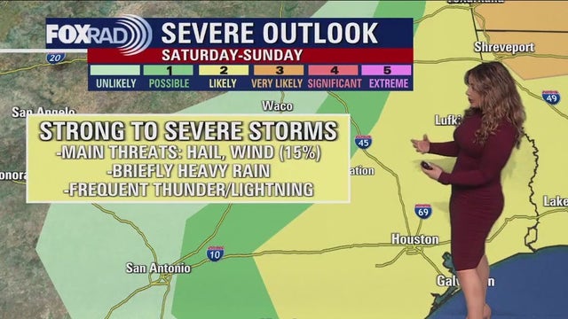
The weekend is almost here and it looks like only a small part of the weekend will include inclement weather. There's a slim shot for a few showers through Saturday morning with mild temperatures overnight near 70. Look for temperatures to soar to near 90 degrees Saturday afternoon ahead of a cold front. Storm risk will be going up, mainly between 7 PM Saturday evening - 1 AM Sunday. Watch out for an isolated strong to severe storm late Saturday with damaging wind and hail. Sunday is much nicer and brighter with less humidity and milder weather. Have a great weekend and make sure to download the FOX 26 Weather app to stay up to date on all the weather changes!
The weekend is almost here and it looks like only a small part of the weekend will include inclement weather. There's a slim shot for a few showers through Saturday morning with mild temperatures overnight near 70. Look for temperatures to soar to near 90 degrees Saturday afternoon ahead of a cold front. Storm risk will be going up, mainly between 7 PM Saturday evening - 1 AM Sunday. Watch out for an isolated strong to severe storm late Saturday with damaging wind and hail. Sunday is much nicer and brighter with less humidity and milder weather. Have a great weekend and make sure to download the FOX 26 Weather app to stay up to date on all the weather changes!

Calm and quiet Friday; storms expected Saturday
Today will be mostly dry and quiet, with increasing clouds and south winds. Most of the day tomorrow will also be dry, but a cold front will bring us a late night round of downpours and storms some of which may be on the stronger side. Main threats are briefly heavy rain and gusty winds, or possibly hail mainly from 7 p.m. to 1 p.m. The weekend ends on a high note with a dry, sunny low humidity day Sunday!
Today will be mostly dry and quiet, with increasing clouds and south winds. Most of the day tomorrow will also be dry, but a cold front will bring us a late night round of downpours and storms some of which may be on the stronger side. Main threats are briefly heavy rain and gusty winds, or possibly hail mainly from 7 p.m. to 1 p.m. The weekend ends on a high note with a dry, sunny low humidity day Sunday!

Houston weather: Another calm and quiet day, though a bit breezy Friday afternoon
Today will be mostly dry and quiet, with increasing clouds and south winds. Most of the day tomorrow will also be dry, but a cold front will bring us a late night round of downpours and storms some of which may be on the stronger side. Main threats are briefly heavy rain and gusty winds, or possibly hail mainly from 7 p.m. to 11 p.m. The weekend ends on a high note with a dry, sunny, low humidity day Sunday!
Today will be mostly dry and quiet, with increasing clouds and south winds. Most of the day tomorrow will also be dry, but a cold front will bring us a late night round of downpours and storms some of which may be on the stronger side. Main threats are briefly heavy rain and gusty winds, or possibly hail mainly from 7 p.m. to 11 p.m. The weekend ends on a high note with a dry, sunny, low humidity day Sunday!

Houston weather: Warm day on the way for Friday, slight chance for storms
Friday will be a warm day with only a 10% chance of an afternoon shower or storm, mainly NW of Houston. Temperatures will soar to the 80s both Friday and Saturday ahead of a cold front. That front will bring in a round of showers and storms Saturday afternoon and evening. There's a low threat of an isolated severe storm Saturday with damaging winds and hail the main threats. Some heavy downpours may send you indoors for a few hours Saturday evening. But once that front moves by, we dry out and quickly clear out making way for a pleasant and bright Sunday. Next week looks pretty quiet with low rain chances back Tuesday. But the heat will be building to the middle 80s by Thursday.
Friday will be a warm day with only a 10% chance of an afternoon shower or storm, mainly NW of Houston. Temperatures will soar to the 80s both Friday and Saturday ahead of a cold front. That front will bring in a round of showers and storms Saturday afternoon and evening. There's a low threat of an isolated severe storm Saturday with damaging winds and hail the main threats. Some heavy downpours may send you indoors for a few hours Saturday evening. But once that front moves by, we dry out and quickly clear out making way for a pleasant and bright Sunday. Next week looks pretty quiet with low rain chances back Tuesday. But the heat will be building to the middle 80s by Thursday.

Houston weather: Foggy, but warm Thursday evening in the 70s
Weather stays pretty quiet for tonight other than some patchy fog that may develop late. Friday will be a warm day with only a 10% chance of an afternoon shower or storm, mainly NW of Houston. Temperatures will soar to the 80s both Friday and Saturday ahead of a cold front. That front will bring in a round of showers and storms Saturday afternoon and evening. There's a low threat of an isolated severe storm Saturday with damaging winds and hail the main threats. Some heavy downpours may send you indoors for a few hours Saturday evening. But once that front moves by, we dry out and quickly clear out making way for a pleasant and bright Sunday. Next week looks pretty quiet with low rain chances back Tuesday. But the heat will be building to the middle 80s by Thursday.
Weather stays pretty quiet for tonight other than some patchy fog that may develop late. Friday will be a warm day with only a 10% chance of an afternoon shower or storm, mainly NW of Houston. Temperatures will soar to the 80s both Friday and Saturday ahead of a cold front. That front will bring in a round of showers and storms Saturday afternoon and evening. There's a low threat of an isolated severe storm Saturday with damaging winds and hail the main threats. Some heavy downpours may send you indoors for a few hours Saturday evening. But once that front moves by, we dry out and quickly clear out making way for a pleasant and bright Sunday. Next week looks pretty quiet with low rain chances back Tuesday. But the heat will be building to the middle 80s by Thursday.

Houston weather: Colorado State University released Hurricane Season Outlook
Thursday will be sunny, bright and quiet. Tomorrow, expect winds to ramp up out of the south increasing humidity and that could spark a few brief stray showers in the afternoon. Saturday will start off Muggy, but an approaching front will change that in the evening. While daytime precipitation will be isolated, look out for downpours and a few stronger storms including gusty winds, and possibly hail mainly from 6-10pm. A few isolated storms may linger near the coast through midnight or just past, but the front will drop our humidity and we'll be back to pleasant, dry days Sunday through early next week!
Thursday will be sunny, bright and quiet. Tomorrow, expect winds to ramp up out of the south increasing humidity and that could spark a few brief stray showers in the afternoon. Saturday will start off Muggy, but an approaching front will change that in the evening. While daytime precipitation will be isolated, look out for downpours and a few stronger storms including gusty winds, and possibly hail mainly from 6-10pm. A few isolated storms may linger near the coast through midnight or just past, but the front will drop our humidity and we'll be back to pleasant, dry days Sunday through early next week!