


FOX 26 Houston Weather Forecast
Get ready for one more chilly night before a big rebound with our temperatures! With clear skies and light wind, Houston should dip to the middle to upper 30s tonight with a light freeze possible N/NW of Houston around Conroe, Huntsville and Brenham. High pressure will keep our weather sunny and quiet for Presidents Day with afternoon temperatures soaring to the middle to upper 60s. Southerly flow increases through the week which means more heat and humidity. Temperatures will be well above normal by Wednesday and Thursday with highs in the low 80s. Overall, this week will feature warmer and drier than average weather. Cold front moves in late Thursday but is not expected to bring any rain. It will bring a slight drop in temperatures for the upcoming weekend. At least weather looks quiet for big events this week like Trail Rides, BBQ Cookoff and Go Texan Day leading up to the start of the Houston Rodeo Season!
Get ready for one more chilly night before a big rebound with our temperatures! With clear skies and light wind, Houston should dip to the middle to upper 30s tonight with a light freeze possible N/NW of Houston around Conroe, Huntsville and Brenham. High pressure will keep our weather sunny and quiet for Presidents Day with afternoon temperatures soaring to the middle to upper 60s. Southerly flow increases through the week which means more heat and humidity. Temperatures will be well above normal by Wednesday and Thursday with highs in the low 80s. Overall, this week will feature warmer and drier than average weather. Cold front moves in late Thursday but is not expected to bring any rain. It will bring a slight drop in temperatures for the upcoming weekend. At least weather looks quiet for big events this week like Trail Rides, BBQ Cookoff and Go Texan Day leading up to the start of the Houston Rodeo Season!


FOX 26 Houston Weather Forecast
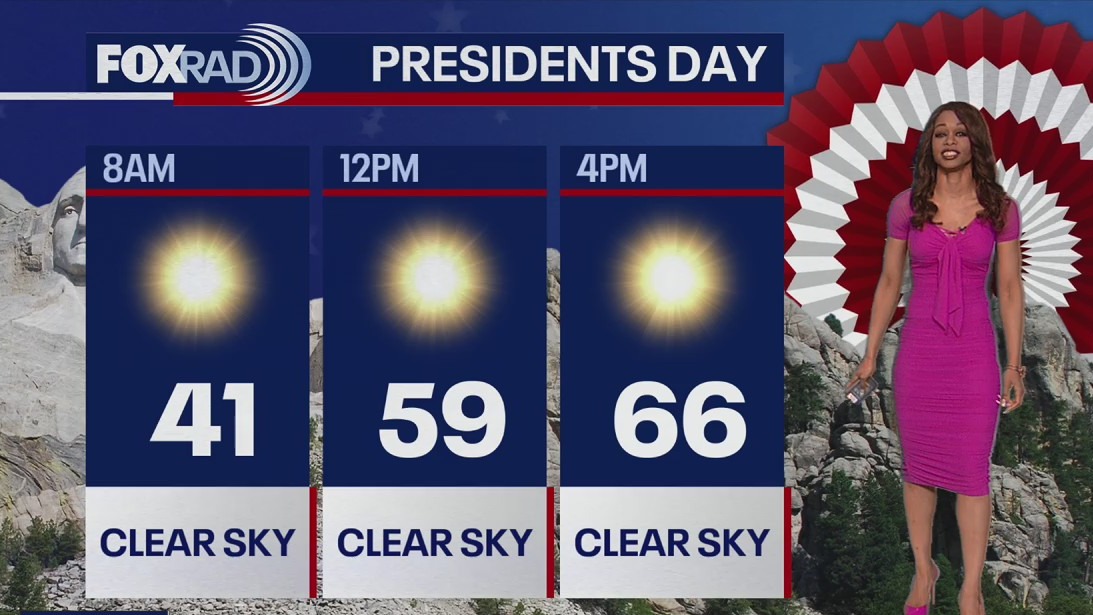
Winter weather has returned briefly for your weekend plans. Bundle up if you're heading out tonight or early Sunday with near freezing temperatures expected. A light freeze is possible N/NW of the Houston Metro tonight so make sure plants and pets are protected. Sunday will feature more sunshine and temperatures climbing to the upper 50s by the afternoon. Southerly breeze returns for Presidents' Day on Monday which will mean temperatures near 70 by the afternoon. Very warm weather is expected Tuesday through Thursday with temperatures near 80. Overall weather pattern should be warmer than normal and drier than average next week for all the events leading up to the start of the 2024 Rodeo season.
Winter weather has returned briefly for your weekend plans. Bundle up if you're heading out tonight or early Sunday with near freezing temperatures expected. A light freeze is possible N/NW of the Houston Metro tonight so make sure plants and pets are protected. Sunday will feature more sunshine and temperatures climbing to the upper 50s by the afternoon. Southerly breeze returns for Presidents' Day on Monday which will mean temperatures near 70 by the afternoon. Very warm weather is expected Tuesday through Thursday with temperatures near 80. Overall weather pattern should be warmer than normal and drier than average next week for all the events leading up to the start of the 2024 Rodeo season.


FOX 26 Houston Weather Forecast
Winter weather has returned briefly for your weekend plans. Bundle up if you're heading out tonight or early Sunday with near freezing temperatures expected. A light freeze is possible N/NW of the Houston Metro tonight so make sure plants and pets are protected. Sunday will feature more sunshine and temperatures climbing to the upper 50s by the afternoon. Southerly breeze returns for Presidents' Day on Monday which will mean temperatures near 70 by the afternoon. Very warm weather is expected Tuesday through Thursday with temperatures near 80. Overall weather pattern should be warmer than normal and drier than average next week for all the events leading up to the start of the 2024 Rodeo season.
Winter weather has returned briefly for your weekend plans. Bundle up if you're heading out tonight or early Sunday with near freezing temperatures expected. A light freeze is possible N/NW of the Houston Metro tonight so make sure plants and pets are protected. Sunday will feature more sunshine and temperatures climbing to the upper 50s by the afternoon. Southerly breeze returns for Presidents' Day on Monday which will mean temperatures near 70 by the afternoon. Very warm weather is expected Tuesday through Thursday with temperatures near 80. Overall weather pattern should be warmer than normal and drier than average next week for all the events leading up to the start of the 2024 Rodeo season.


FOX 26 Houston Weather Forecast
It is a cold and blustery Saturday in Houston. Temperatures today will be stuck in the upper-40s to near 50 degrees with sustained winds out of the north from 15-20 mph and gusts up to 30 mph. Wake up temperatures on Sunday will be in the 30s with clear skies. As we head into next week, spring-like weather returns. Forecast highs Wednesday and Thursday will be in the low-80s. That is great news for the start of 2024 Rodeo season! For the BBQ Cookoff, Go Texan Day & trail rides, skies remain dry. Head over to the FOX Local app on your smart tv to get an in-depth forecast on the weather roller coaster from Chief Meteorologist Mike Iscovitz.
It is a cold and blustery Saturday in Houston. Temperatures today will be stuck in the upper-40s to near 50 degrees with sustained winds out of the north from 15-20 mph and gusts up to 30 mph. Wake up temperatures on Sunday will be in the 30s with clear skies. As we head into next week, spring-like weather returns. Forecast highs Wednesday and Thursday will be in the low-80s. That is great news for the start of 2024 Rodeo season! For the BBQ Cookoff, Go Texan Day & trail rides, skies remain dry. Head over to the FOX Local app on your smart tv to get an in-depth forecast on the weather roller coaster from Chief Meteorologist Mike Iscovitz.


FOX 26 Houston Weather Forecast
We are about to jump into another weekend and this one is a holiday weekend! We'll be on a roller coaster ride with big temperature swings over the coming days. Overall. rain is starting to wind down and there's only a small chance for a light rain shower tonight through early Saturday. Get ready for a strong cold front to drop in overnight that will bring a return to winter weather for a few days. Temperatures will dip to the 40s tonight and likely stay in the 40s Saturday. By Sunday morning, we should dip to the upper 30s in Houston with temperatures right around freezing up around Conroe, Brenham, and Huntsville. So don't put the coats away just yet! Then spring-like weather quickly returns for Presidents' Day with highs near 70 Monday afternoon. We get even warmer heading towards the start of the BBQ Cookoff, Go Texan Day & for the Trail Riders. In fact, it looks like drier than normal weather will prevail for much of next week which will be great for events leading up to the start of the 2024 Rodeo!
We are about to jump into another weekend and this one is a holiday weekend! We'll be on a roller coaster ride with big temperature swings over the coming days. Overall. rain is starting to wind down and there's only a small chance for a light rain shower tonight through early Saturday. Get ready for a strong cold front to drop in overnight that will bring a return to winter weather for a few days. Temperatures will dip to the 40s tonight and likely stay in the 40s Saturday. By Sunday morning, we should dip to the upper 30s in Houston with temperatures right around freezing up around Conroe, Brenham, and Huntsville. So don't put the coats away just yet! Then spring-like weather quickly returns for Presidents' Day with highs near 70 Monday afternoon. We get even warmer heading towards the start of the BBQ Cookoff, Go Texan Day & for the Trail Riders. In fact, it looks like drier than normal weather will prevail for much of next week which will be great for events leading up to the start of the 2024 Rodeo!


FOX 26 Houston Weather Forecast
We are about to jump into another weekend and this one is a holiday weekend! We'll be on a roller coaster ride with big temperature swings over the coming days. Overall, rain is starting to wind down and there's only a small chance for a light rain shower tonight through early Saturday. Get ready for a strong cold front to drop in overnight that will bring a return to winter weather for a few days. Temperatures will dip to the 40s tonight and likely stay in the 40s Saturday. By Sunday morning, we should dip to the upper 30s in Houston with temperatures right around freezing up around Conroe, Brenham, and Huntsville. So don't put the coats away just yet! Then spring-like weather quickly returns for Presidents' Day with highs near 70 Monday afternoon. We get even warmer heading towards the start of the BBQ Cookoff, Go Texan Day & for the Trail Riders. In fact, it looks like drier-than-normal weather will prevail for much of next week which will be great for events leading up to the start of the 2024 Rodeo!
We are about to jump into another weekend and this one is a holiday weekend! We'll be on a roller coaster ride with big temperature swings over the coming days. Overall, rain is starting to wind down and there's only a small chance for a light rain shower tonight through early Saturday. Get ready for a strong cold front to drop in overnight that will bring a return to winter weather for a few days. Temperatures will dip to the 40s tonight and likely stay in the 40s Saturday. By Sunday morning, we should dip to the upper 30s in Houston with temperatures right around freezing up around Conroe, Brenham, and Huntsville. So don't put the coats away just yet! Then spring-like weather quickly returns for Presidents' Day with highs near 70 Monday afternoon. We get even warmer heading towards the start of the BBQ Cookoff, Go Texan Day & for the Trail Riders. In fact, it looks like drier-than-normal weather will prevail for much of next week which will be great for events leading up to the start of the 2024 Rodeo!


FOX 26 Houston Weather Forecast
Get ready for a weather rollercoaster over the next few days! Rainy, drizzly weather will hang around through the early afternoon, then attention turns to a cold front overnight. Plan on a cold, windy Saturday with temperatures stuck in the 40s for much of the day and winds of 20 mph from the north. Sunday morning lows should drop into the 30s, but sunshine returns by afternoon and a mild, spring-like pattern will return for next week.
Get ready for a weather rollercoaster over the next few days! Rainy, drizzly weather will hang around through the early afternoon, then attention turns to a cold front overnight. Plan on a cold, windy Saturday with temperatures stuck in the 40s for much of the day and winds of 20 mph from the north. Sunday morning lows should drop into the 30s, but sunshine returns by afternoon and a mild, spring-like pattern will return for next week.

FOX 26 Houston Weather Forecast - Widespread rain on the way
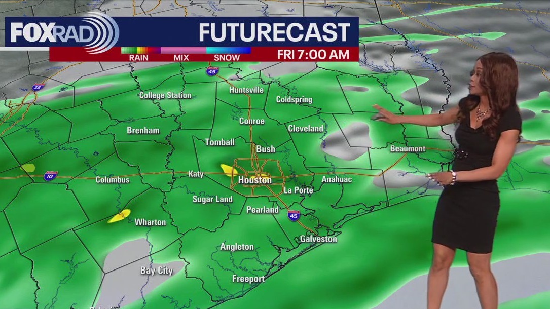
Get ready for widespread rain to roll in by Friday morning. Severe weather is not expected but steady light to moderate rain is a good bet as a coastal low develops and moves close to our area. Heaviest rain is expected to be south of I-10 close to the coast with totals around 1" possible Friday and Saturday. Temperatures will remain on the mild side Friday but expect a big drop in temperatures Saturday. That is because a cold front will move through late Friday into early Saturday. High temperatures Saturday will only be near 50 with some areas just outside of Houston near freezing Sunday morning. Presidents' Day is looking pleasant and dry with temperatures near 70. Big warming trend will commence next week as we are back close to 80 by Tuesday. The World's Championship BBQ Cookoff is just one week away and it looks warm and dry for the start of it for now.
Get ready for widespread rain to roll in by Friday morning. Severe weather is not expected but steady light to moderate rain is a good bet as a coastal low develops and moves close to our area. Heaviest rain is expected to be south of I-10 close to the coast with totals around 1" possible Friday and Saturday. Temperatures will remain on the mild side Friday but expect a big drop in temperatures Saturday. That is because a cold front will move through late Friday into early Saturday. High temperatures Saturday will only be near 50 with some areas just outside of Houston near freezing Sunday morning. Presidents' Day is looking pleasant and dry with temperatures near 70. Big warming trend will commence next week as we are back close to 80 by Tuesday. The World's Championship BBQ Cookoff is just one week away and it looks warm and dry for the start of it for now.


FOX 26 Houston Weather Forecast
Get ready for widespread rain to roll in by Friday morning. Severe weather is not expected but steady light to moderate rain is a good bet as a coastal low develops and moves close to our area. Heaviest rain is expected to be south of I-10 close to the coast with totals around 1" possible Friday and Saturday. Temperatures will remain on the mild side Friday but expect a big drop in temperatures Saturday. That is because a cold front will move through late Friday into early Saturday. High temperatures Saturday will only be near 50 with some areas just outside of Houston near freezing Sunday morning. Presidents' Day is looking pleasant and dry with temperatures near 70. Big warming trend will commence next week as we are back close to 80 by Tuesday. The World's Championship BBQ Cookoff is just one week away and it looks warm and dry for the start of it for now.
Get ready for widespread rain to roll in by Friday morning. Severe weather is not expected but steady light to moderate rain is a good bet as a coastal low develops and moves close to our area. Heaviest rain is expected to be south of I-10 close to the coast with totals around 1" possible Friday and Saturday. Temperatures will remain on the mild side Friday but expect a big drop in temperatures Saturday. That is because a cold front will move through late Friday into early Saturday. High temperatures Saturday will only be near 50 with some areas just outside of Houston near freezing Sunday morning. Presidents' Day is looking pleasant and dry with temperatures near 70. Big warming trend will commence next week as we are back close to 80 by Tuesday. The World's Championship BBQ Cookoff is just one week away and it looks warm and dry for the start of it for now.


FOX 26 Houston Weather Forecast
There will be lots of clouds today but not much rain as a gulf breeze brings more humidity across Houston. Look for mild temperatures until a front arrives early Saturday. Highs this afternoon will be in the lower 70s. Before the front arrives, rain will move in early Friday and continue through most of the day. The highest chances for storms will be south of Houston closer to the coast. The holiday weekend ends with cool mornings and pleasant afternoons.
There will be lots of clouds today but not much rain as a gulf breeze brings more humidity across Houston. Look for mild temperatures until a front arrives early Saturday. Highs this afternoon will be in the lower 70s. Before the front arrives, rain will move in early Friday and continue through most of the day. The highest chances for storms will be south of Houston closer to the coast. The holiday weekend ends with cool mornings and pleasant afternoons.


Fox 26 Houston Weather Forecast
Lots of weather changes are on the way - some pleasant, some not so much. Today looks decent enough with a cloudy sky, gulf breezes, and highs in the low 70s. Rain will move in by early Friday and continue through most of the day. The highest chance for storms will be south of Houston and closer to the coast. Total rainfall should average around 1". Saturday will be chilly with lingering showers along the coast. Sunday and Monday look beautiful, but overnight, low temps will be cold.
Lots of weather changes are on the way - some pleasant, some not so much. Today looks decent enough with a cloudy sky, gulf breezes, and highs in the low 70s. Rain will move in by early Friday and continue through most of the day. The highest chance for storms will be south of Houston and closer to the coast. Total rainfall should average around 1". Saturday will be chilly with lingering showers along the coast. Sunday and Monday look beautiful, but overnight, low temps will be cold.


FOX 26 Houston Weather Forecast
Lots of weather changes are on the way - some pleasant, some not so much. Today looks decent enough with a cloudy sky, gulf breezes and highs in the low 70s. Rain will move in by early Friday and continue through most of the day. The highest chance for storms will be south of Houston and closer to the coast. Total rainfall should average around 1". Saturday will be chilly with lingering showers along the coast. Sunday and Monday look beautiful, but overnight low temps will be cold.
Lots of weather changes are on the way - some pleasant, some not so much. Today looks decent enough with a cloudy sky, gulf breezes and highs in the low 70s. Rain will move in by early Friday and continue through most of the day. The highest chance for storms will be south of Houston and closer to the coast. Total rainfall should average around 1". Saturday will be chilly with lingering showers along the coast. Sunday and Monday look beautiful, but overnight low temps will be cold.


FOX 26 Houston Weather Forecast
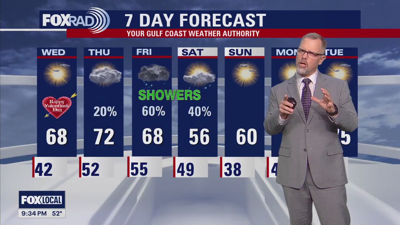
Happy Valentine's Day! At least the weather will remain quiet for any date night plans. There will be a bit of a chill in the air as temperatures dip to near 60 around 7 PM and middle 50s by 10 PM. Skies will remain partly cloudy to mostly cloudy with no rain or storms expected. Look for more clouds Thursday with some patchy fog/drizzle at times. More widespread rain should build in Friday with the heaviest rain expected closer to the coast. Some light showers will linger early Saturday. A cold front will mean much cooler temperatures for the weekend with some areas north of Houston near freezing Sunday morning. Big warming trend will have temperatures back up to around 80 by the middle of next week. Grab our Fox Local App for your smart tv for special news and weather content and live streams of our newscasts
Happy Valentine's Day! At least the weather will remain quiet for any date night plans. There will be a bit of a chill in the air as temperatures dip to near 60 around 7 PM and middle 50s by 10 PM. Skies will remain partly cloudy to mostly cloudy with no rain or storms expected. Look for more clouds Thursday with some patchy fog/drizzle at times. More widespread rain should build in Friday with the heaviest rain expected closer to the coast. Some light showers will linger early Saturday. A cold front will mean much cooler temperatures for the weekend with some areas north of Houston near freezing Sunday morning. Big warming trend will have temperatures back up to around 80 by the middle of next week. Grab our Fox Local App for your smart tv for special news and weather content and live streams of our newscasts


FOX 26 Houston Weather Forecast
Overall, today's weather looks lovely for Valentine's Day and Ash Wednesday. A gulf breeze will return today, so we will transition to a more humid and cloudy pattern tonight through Saturday. Another blanket of rain is expected Friday and possibly Saturday but with much nicer weather for the rest of the three-day weekend.
Overall, today's weather looks lovely for Valentine's Day and Ash Wednesday. A gulf breeze will return today, so we will transition to a more humid and cloudy pattern tonight through Saturday. Another blanket of rain is expected Friday and possibly Saturday but with much nicer weather for the rest of the three-day weekend.


FOX 26 Houston Weather Forecast
Clear and cold this morning, then partly cloudy with highs in the upper 60s.
Clear and cold this morning, then partly cloudy with highs in the upper 60s.

FOX 26 Houston Weather Forecast
Look for a lovely day on Wednesday with seasonal temperatures for Houston. Rain chances start to return on Thursday but don't expect widespread showers until Friday. Showers will linger around for the start of the weekend but a cold front clears the skies and brings cooler temperatures for Saturday night and Sunday
Look for a lovely day on Wednesday with seasonal temperatures for Houston. Rain chances start to return on Thursday but don't expect widespread showers until Friday. Showers will linger around for the start of the weekend but a cold front clears the skies and brings cooler temperatures for Saturday night and Sunday


FOX 26 Houston Weather Forecast
We have a beautiful Tuesday ahead with clear and dry skies. Highs today will be in the mid-60s and rising to near 70 by Thursday. Our next chance for rain moves in on Friday, and cooler temperatures are expected this weekend.
We have a beautiful Tuesday ahead with clear and dry skies. Highs today will be in the mid-60s and rising to near 70 by Thursday. Our next chance for rain moves in on Friday, and cooler temperatures are expected this weekend.


FOX 26 Houston Weather Forecast
Clear, calm and cold this morning, then sunny and pleasant with highs near 65.
Clear, calm and cold this morning, then sunny and pleasant with highs near 65.