

Major winter storm to spread snow, ice from Texas to Midwest, Northeast starting on eve of Groundhog Day
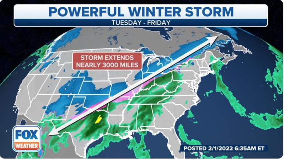
A major winter storm is brewing from Texas and the Plains to the Midwest and Northeast, where significant amounts of snow and ice will likely cause widespread travel disruptions and power outages starting Tuesday night.
Frigid arctic air will move into the nation's heartland by Groundhog Day as a cold front sweeps down across the Plains. Moisture from the Gulf of Mexico will surge northward ahead of the front.
That moisture will overlap with the fresh supply of cold air, setting the stage for an expansive area of snow and ice impacting millions of Americans from the nation's southern border to its northern border.
THESE ARE THE 7 SNOWIEST CITIES IN THE U.S.
(FOX Weather)
The National Weather Service has issued Winter Storm Warnings, Winter Storm Watches and Winter Weather Advisories from parts of New Mexico and Texas northeastward to upstate New York and much of Vermont.
Cities under Winter Storm Warnings include Kansas City, St. Louis, Chicago and Cleveland. The Winter Storm Watches include Dallas/Fort Worth and Austin in Texas, Indianapolis, Detroit, Pittsburgh, Buffalo and Syracuse in New York and Burlington in Vermont.
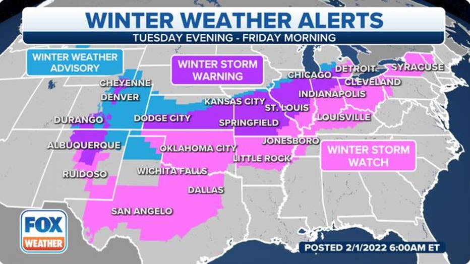
Various winter weather alerts are in effect from parts of New Mexico and Texas northeastward to upstate New York and much of Vermont. (FOX Weather)
Snow, sleet and/or freezing rain will make driving conditions hazardous in these regions on one or more days this week, so you're advised to postpone or cancel any travel plans along the path of this winter storm. The blast of frigid air following in the storm's wake could cause roads to remain icy even after the precipitation ends.
BITTER COLD COMING TO TEXAS THIS WEEK BUT IT WON'T BE 2021 ALL OVER AGAIN
Here is our current outlook for the storm's timing, followed by the predicted snow and ice amounts. Be sure to download the FOX Weather app for the latest forecast and weather alerts for your exact location, plus the 24/7 livestream.
Storm timing
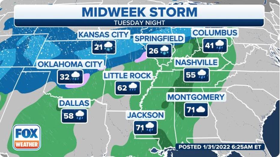
Tuesday night
Snow, sleet and freezing rain are forecast to turn widespread from the central and southern Rockies and the Central Plains to portions of the Midwest and southern Great Lakes.
Forecast for Tuesday night, Feb. 1, 2022. (FOX Weather)
Wednesday-Wednesday night
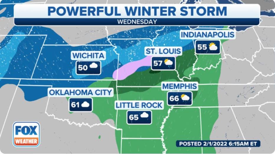
On Groundhog Day, snow, sleet and freezing rain will continue from central and southern portions of the Rockies and Plains to parts of the Midwest and southern Great Lakes.
The snow could become heavy in some of these areas, and the sleet and freezing rain might reach as far south as Oklahoma and northern Texas.
Forecast for Wednesday, Feb. 2, 2022 (Groundhog Day). (FOX Weather)
By Wednesday night, rain could change to freezing rain as far south as North and Central Texas, including the Dallas/Fort Worth Metroplex. This would create a glaze of ice on many roads.
7 THINGS TO KNOW ABOUT FREEZING RAIN
There may even be some snow, sleet or ice arriving in the interior Northeast and northern New England later Wednesday night. However, a warmer southerly breeze should allow for mainly rain in southern New England and the mid-Atlantic.
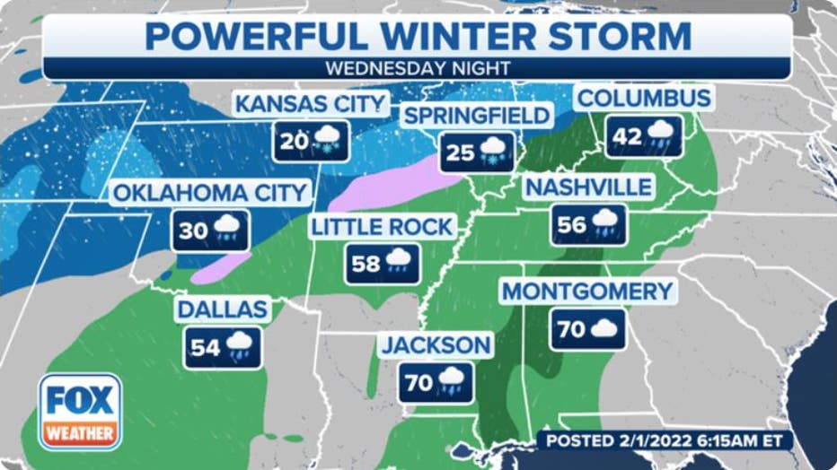
Forecast for Wednesday night, Feb. 2, 2022 (Groundhog Day). (FOX Weather)
Thursday-Thursday night
An expansive area of snow, sleet and freezing rain is likely from as far south as Central and West Texas to the Ohio Valley, Great Lakes, upstate New York and northern New England.
On the storm's warm side, a soaking rain is expected for much of the Northeast, including southern New England.
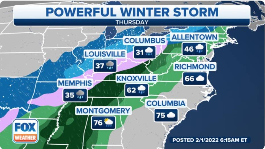
Forecast for Thursday, Feb. 3, 2022. (FOX Weather)
By Thursday night, the wintry mess of precipitation should taper off in the Southern Plains, but snow, sleet and freezing rain will continue overnight from the mid-Mississippi and Ohio valleys to the interior Northeast.
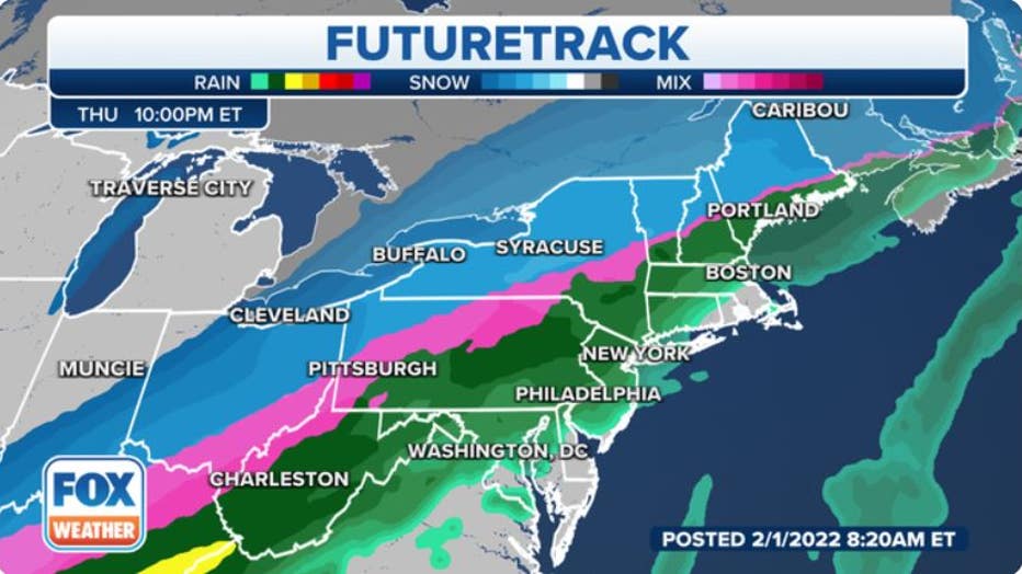
Forecast for Thursday night, Feb. 3, 2022. (FOX Weather)
Friday
This storm's cold front will finally reach the Northeast by Friday morning, which could usher in enough cold air to change the rain over to a period of snow, sleet or ice from southern New England to the New York City tri-state area.
Slick travel conditions are possible in at least parts of the Northeast on Friday where the rain is able to change to wintry precipitation.
This storm should finally exit off the Northeast coast on Friday night, with another blast of frigid air following in its wake this weekend.
ARCTIC AIR TO REMAIN IN PLACE AFTER POWERFUL STORM SYSTEM INVADES CENTRAL, EASTERN U.S.
How much snow?
At least 6 inches of snow will likely pile up over a large area from the central and southern Rockies and the Central Plains into the Midwest, southern Great Lakes, upstate New York and northern New England. Some of these areas could see more than a foot of snow.
Cities with the potential to pick up 6-plus inches of snow include Kansas City, St. Louis, Chicago (especially south Chicagoland), Indianapolis, Cleveland, Detroit, Buffalo and Syracuse in New York and Burlington in Vermont.
Light accumulations of snow are possible as far south as western and northern Texas.
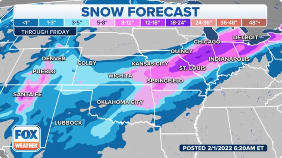
Snow forecast through Friday, Feb. 4, 2022.(FOX Weather)
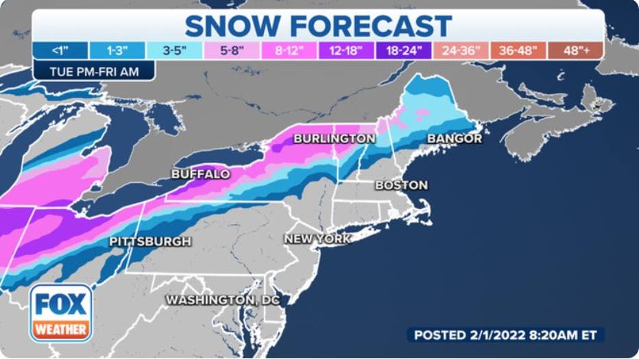
Snow forecast through Friday, Feb. 4, 2022. (FOX Weather)
How much ice?
Ice accumulations from freezing rain are possible over an expansive area from North and Central Texas to southern and eastern Oklahoma, the Ozarks, the mid-Mississippi and Ohio valleys and the interior Northeast.
All locations that have a period of freezing rain should see at least a glaze of ice, which is sufficient to create icy roads and dangerous driving conditions. Scattered power outages and broken tree limbs are also not ruled out, even as far south as north-central Texas.
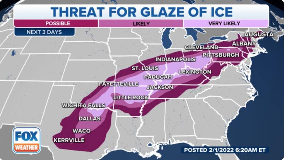
Threat for a glaze of ice through Thursday, Feb. 3, 2022. (FOX Weather)
In some areas, the accretion of ice on tree branches and power lines could become heavy enough to cause more widespread power outages and tree damage.
HOW MUCH ICE IS NEEDED TO KNOCK OUT POWER, DAMAGE TREES?
The highest risk for this disruptive ice appears to be from the Ozarks of southern Missouri and northern Arkansas northeastward into southern Ohio. One-quarter to one-half inch of ice is possible in some of these areas.
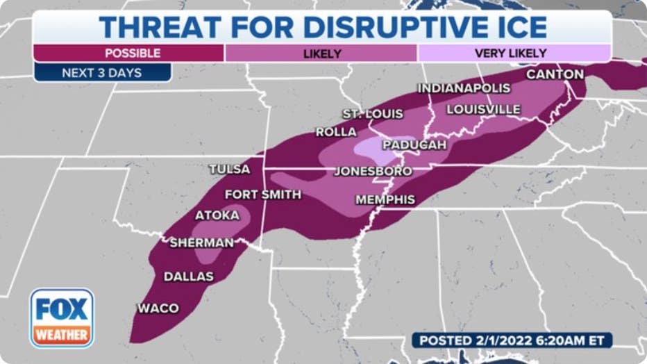
The threat for disruptive ice capable of tree damage and power outages. (FOX Weather)