

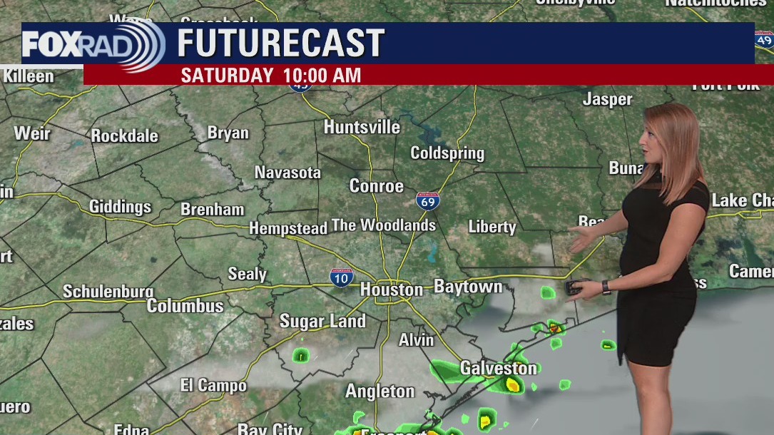

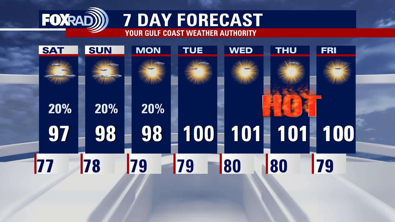
Saturday morning weather forecast
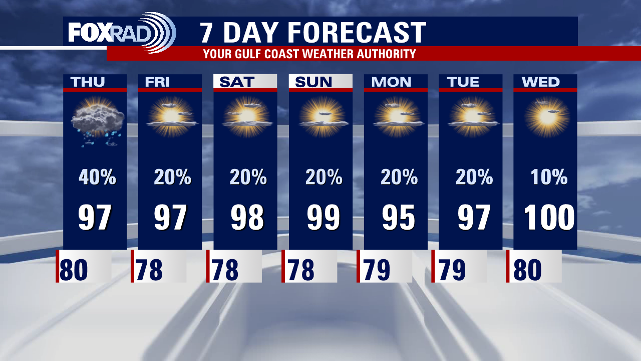
Another ridge of high pressure begins to build this weekend, allowing for more sunshine and drier conditions to settle in. An isolated shower or thunderstorm will still be possible but the activity looks to be very hit or miss in variety. Temperatures will again be on the rise, with highs in the triple digits by the middle of next week.
Another ridge of high pressure begins to build this weekend, allowing for more sunshine and drier conditions to settle in. An isolated shower or thunderstorm will still be possible but the activity looks to be very hit or miss in variety. Temperatures will again be on the rise, with highs in the triple digits by the middle of next week.

Friday evening weather forecast with Meteorologist Adrienne Vonn
Another ridge of high pressure begins to build this weekend, allowing for more sunshine and drier conditions to settle in. An isolated shower or thunderstorm will still be possible but the activity looks to be very hit or miss in variety. Temperatures will again be on the rise, with highs in the triple digits by the middle of next week.
Another ridge of high pressure begins to build this weekend, allowing for more sunshine and drier conditions to settle in. An isolated shower or thunderstorm will still be possible but the activity looks to be very hit or miss in variety. Temperatures will again be on the rise, with highs in the triple digits by the middle of next week.
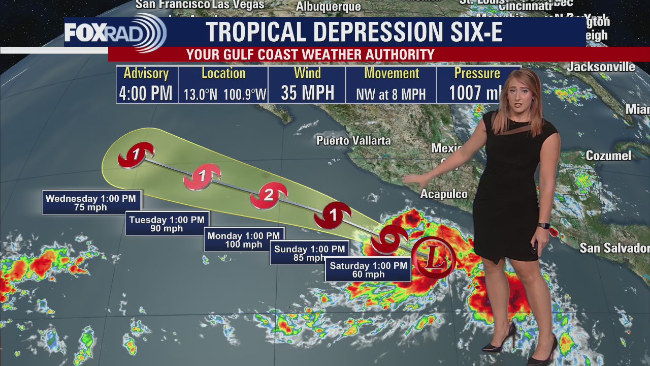

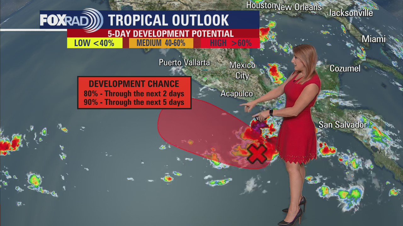
Tropical Weather Forecast - July 15, 2022
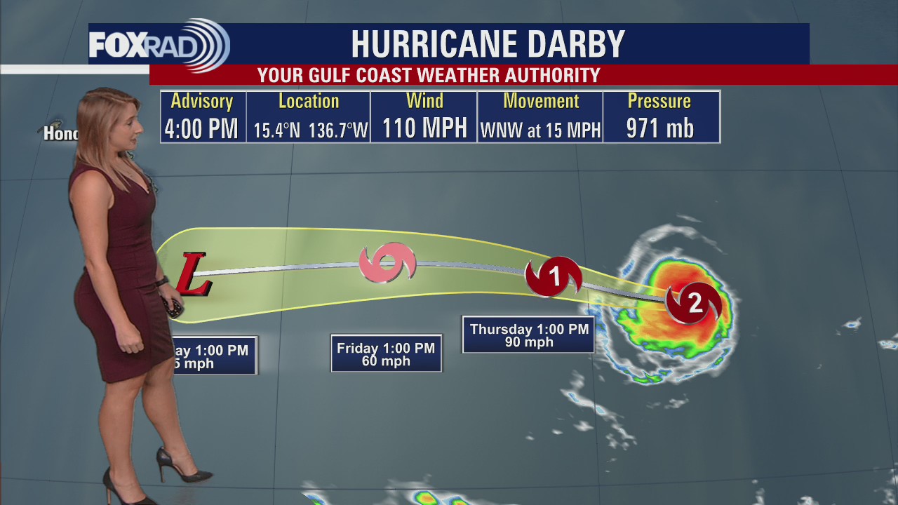
The Atlantic Basin remains very quiet with Saharan Dust continuing to move through. Meanwhile in the Pacific, Darby continues to weaken and is expected to become a remnant low in the next 24 hours. Beneficial rain from Darby will spread over the Hawaiian Islands this weekend with breezy conditions. Tropical Depression Six-E could become our next named storm in the Eastern Pacific.
The Atlantic Basin remains very quiet with Saharan Dust continuing to move through. Meanwhile in the Pacific, Darby continues to weaken and is expected to become a remnant low in the next 24 hours. Beneficial rain from Darby will spread over the Hawaiian Islands this weekend with breezy conditions. Tropical Depression Six-E could become our next named storm in the Eastern Pacific.

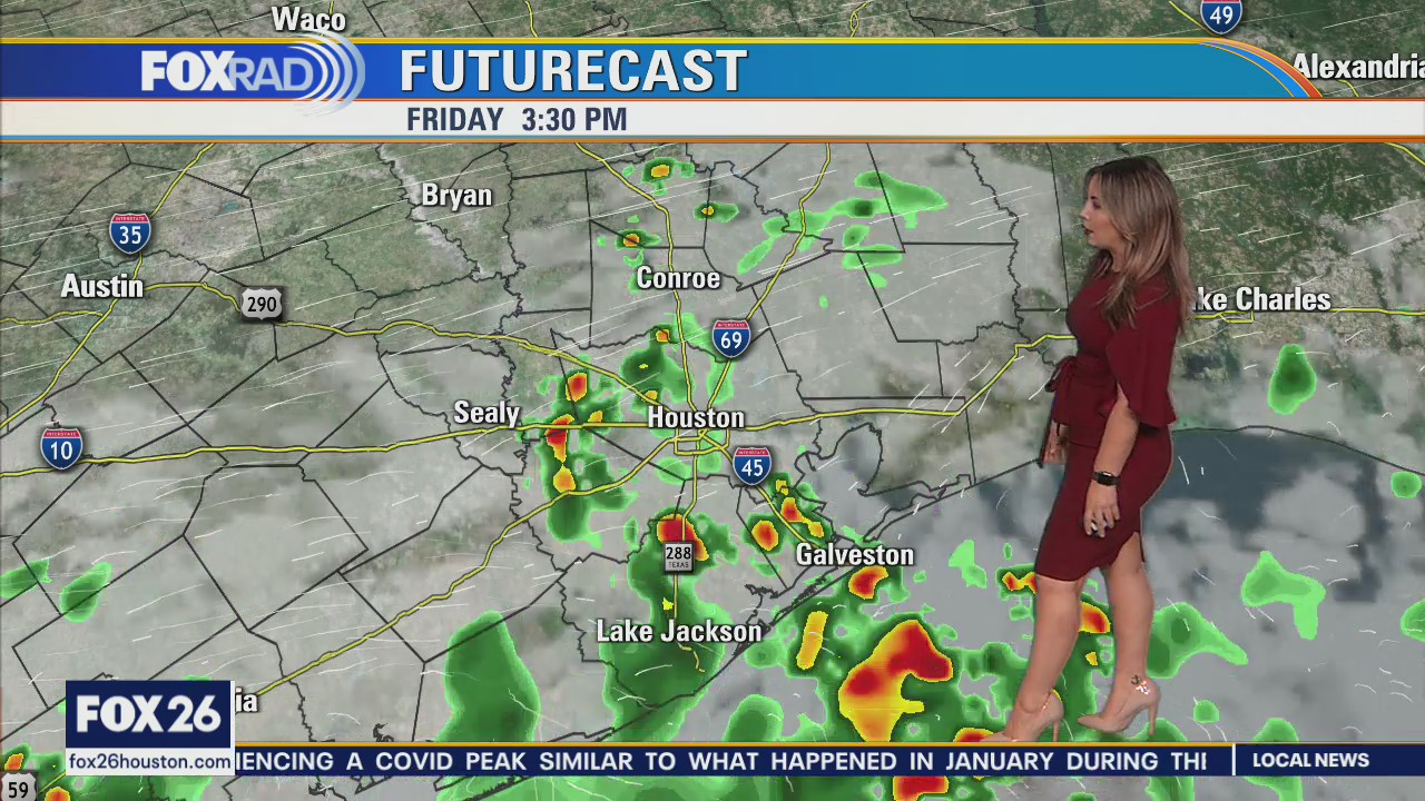
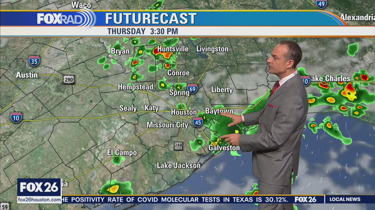
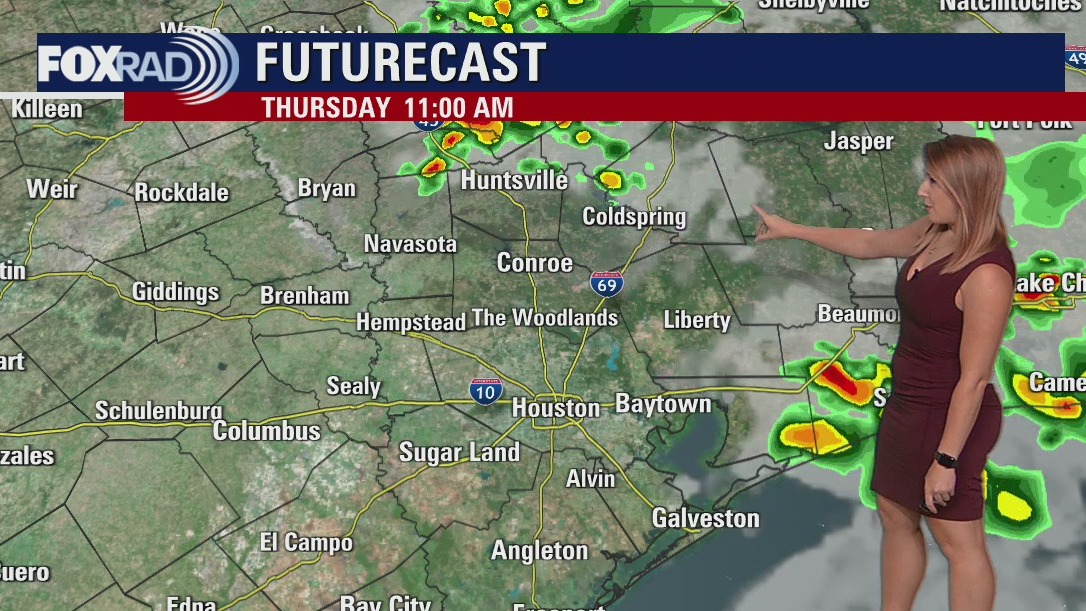
Friday afternoon weather forecast with Meteorologist Lena Maria Arango
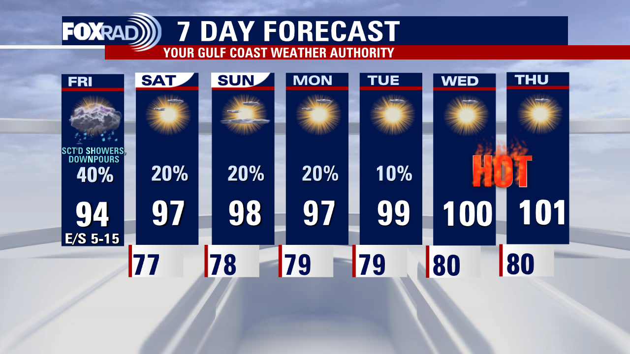
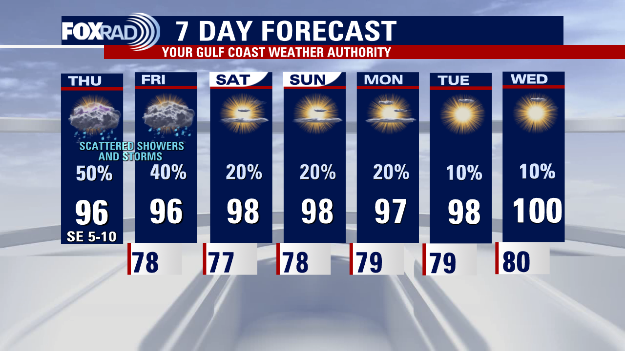
A disturbance in the gulf is driving in a deep plume of moisture keeping heavy rain a possibility mainly along the coastline today. Activity inland will be more scattered as the day goes on but look for pockets of downpours and a few rumbles of thunder. Hopefully, you get lucky today, because it's our best opportunity for rainfall before chances drop significantly. Heat and humidity will be back on the rise as another ridge of high-pressure build and we'll be back to monitoring for heat advisories and hundo's once again by the middle of next week.
A disturbance in the gulf is driving in a deep plume of moisture keeping heavy rain a possibility mainly along the coastline today. Activity inland will be more scattered as the day goes on but look for pockets of downpours and a few rumbles of thunder. Hopefully, you get lucky today, because it's our best opportunity for rainfall before chances drop significantly. Heat and humidity will be back on the rise as another ridge of high-pressure build and we'll be back to monitoring for heat advisories and hundo's once again by the middle of next week.


Scary video of waterspout blowing people over in Galveston
A FOX 26 viewer shared shocking footage of a waterspout coming onshore Thursday afternoon in Galveston and blowing people over. Fortunately, there were no reported injuries. (Video courtesy: Mario E. Halkyer)
A FOX 26 viewer shared shocking footage of a waterspout coming onshore Thursday afternoon in Galveston and blowing people over. Fortunately, there were no reported injuries. (Video courtesy: Mario E. Halkyer)

More rainfall expected today
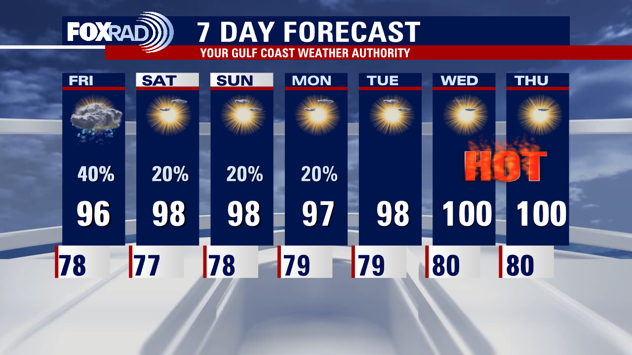
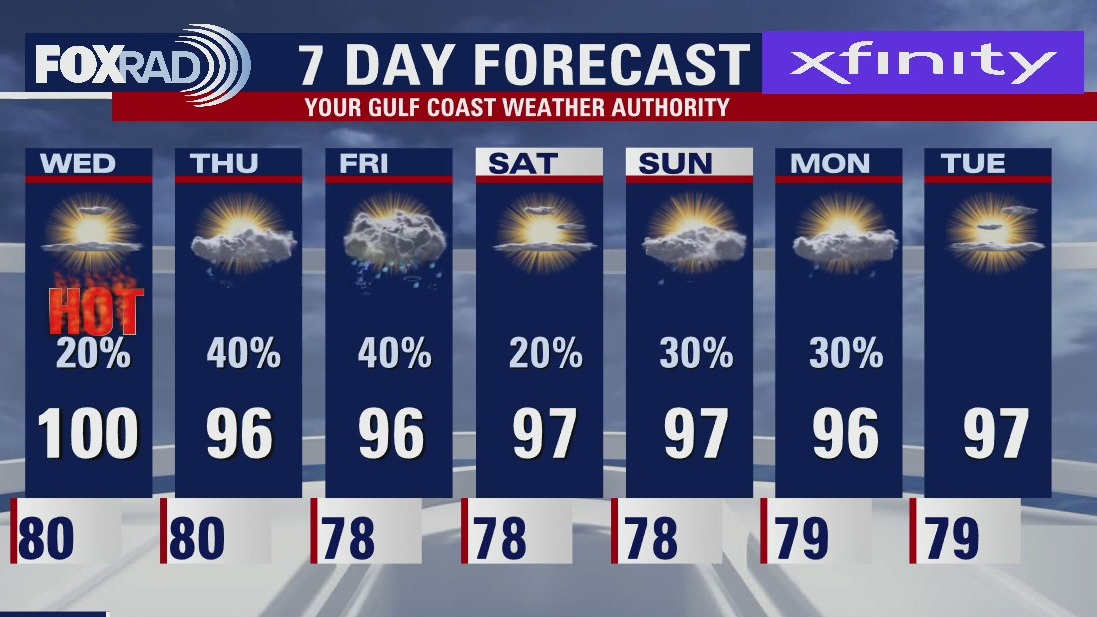
One more decent chance at beneficial rainfall exists today, primarily along the coastline. Showers, and isolated downpours, and thunderstorms look to propagate inland some throughout the afternoon. Increased cloud cover should keep most daytime highs in the low-mid 90s. The weekend looks warmer, more humid and with lower rain chances though keep your eyes on the FOX 26 Weather app for an occasional passing shower or storm. Rain chances continue to drop as we head into next week, and not what you wanted to hear, I know, but we crank up the heat to near 100 again as another ridge of high pressure builds.
One more decent chance at beneficial rainfall exists today, primarily along the coastline. Showers, and isolated downpours, and thunderstorms look to propagate inland some throughout the afternoon. Increased cloud cover should keep most daytime highs in the low-mid 90s. The weekend looks warmer, more humid and with lower rain chances though keep your eyes on the FOX 26 Weather app for an occasional passing shower or storm. Rain chances continue to drop as we head into next week, and not what you wanted to hear, I know, but we crank up the heat to near 100 again as another ridge of high pressure builds.
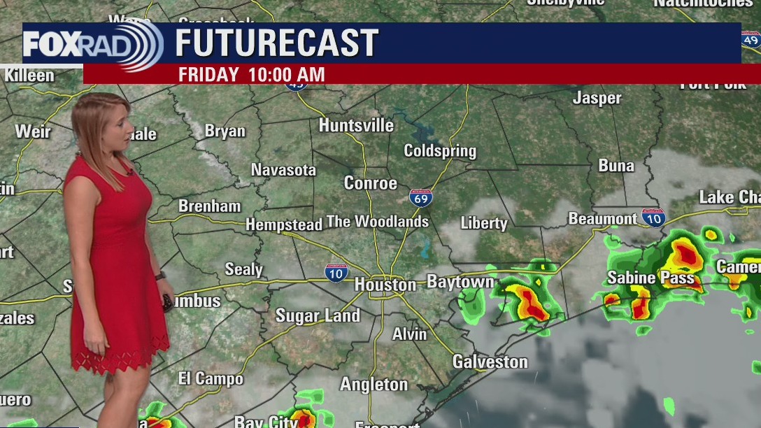

Friday morning weather forecast
Scattered rain and thunderstorm chances continue tomorrow, with the highest coverage in the morning and early afternoon. We'll trend drier as we head into the weekend with more sunshine and more heat. Highs will again soar to the century mark by the middle of next week.
Scattered rain and thunderstorm chances continue tomorrow, with the highest coverage in the morning and early afternoon. We'll trend drier as we head into the weekend with more sunshine and more heat. Highs will again soar to the century mark by the middle of next week.

Thursday evening weather forecast with Meteorologist Adrienne Vonn
Scattered rain and thunderstorm chances continue tomorrow, with the highest coverage in the morning and early afternoon. We'll trend drier as we head into the weekend with more sunshine and more heat. Highs will again soar to the century mark by the middle of next week.
Scattered rain and thunderstorm chances continue tomorrow, with the highest coverage in the morning and early afternoon. We'll trend drier as we head into the weekend with more sunshine and more heat. Highs will again soar to the century mark by the middle of next week.

Tropical Weather Forecast - July 14, 2022
Darby continues to churn the Pacific bringing large swells and some rain to Hawaii, rapid weakening is expected heading into the weekend. The Atlantic Basin remains very quiet with Saharan Dust arriving in Texas this weekend.
Darby continues to churn the Pacific bringing large swells and some rain to Hawaii, rapid weakening is expected heading into the weekend. The Atlantic Basin remains very quiet with Saharan Dust arriving in Texas this weekend.
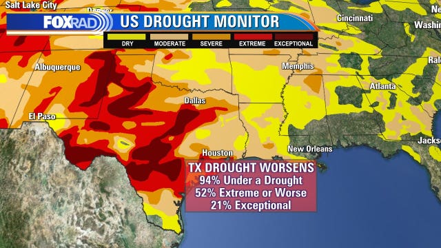

As Texas drought worsens, is there any relief in sight?
New numbers are out and the drought in Texas is getting worse. How much rain would we need to break out of this situation? Most likely these areas would need at least 12-15" of rain to get back to normal.
New numbers are out and the drought in Texas is getting worse. How much rain would we need to break out of this situation? Most likely these areas would need at least 12-15" of rain to get back to normal.

Thursday afternoon weather forecast with Meteorologist Lena Maria Arango
Our highest rain chances are between today and tomorrow, with scattered showers, storms, and even a few downpours possible. A stronger storm or two may mix down some gusty winds, but severe weather is not expected. Tomorrow morning, some heavier rain is possible along the coast with showers and storms pushing inland throughout the day. Past that, our rain chances drop back to the daily lotto category and the heat and humidity continue. Enjoy the slightly subdued temperatures, for now, looks like we'll be adding more 100s to the triple-digit tally fairly soon. Saharan dust looks to keep the Atlantic quiet through the next 2-5 days.
Our highest rain chances are between today and tomorrow, with scattered showers, storms, and even a few downpours possible. A stronger storm or two may mix down some gusty winds, but severe weather is not expected. Tomorrow morning, some heavier rain is possible along the coast with showers and storms pushing inland throughout the day. Past that, our rain chances drop back to the daily lotto category and the heat and humidity continue. Enjoy the slightly subdued temperatures, for now, looks like we'll be adding more 100s to the triple-digit tally fairly soon. Saharan dust looks to keep the Atlantic quiet through the next 2-5 days.

Cooling storms expected today
After 6 consecutive days of 100+ heat, many areas will have cooling storms today. Highs could stay in the mid-90s in the Houston area, but a few strong storms are possible. Counties west of Harris and Montgomery Co are under a heat advisory with less rain and highs near 100. We may see a few more scattered storms on Friday, but sunshine and a very hot pattern will resume this weekend through next week. The tropics remain quiet.
After 6 consecutive days of 100+ heat, many areas will have cooling storms today. Highs could stay in the mid-90s in the Houston area, but a few strong storms are possible. Counties west of Harris and Montgomery Co are under a heat advisory with less rain and highs near 100. We may see a few more scattered storms on Friday, but sunshine and a very hot pattern will resume this weekend through next week. The tropics remain quiet.

Thursday morning weather forecast
High heat and humidity continue to grip Southeast Texas. While highs tomorrow won't quiet reach the century mark, our 'feels like' temperatures again will soar past 100. Our best chance for rain arrives tomorrow with scattered showers and thunderstorms around. More heat is expected this weekend with limited rain chances continuing.
High heat and humidity continue to grip Southeast Texas. While highs tomorrow won't quiet reach the century mark, our 'feels like' temperatures again will soar past 100. Our best chance for rain arrives tomorrow with scattered showers and thunderstorms around. More heat is expected this weekend with limited rain chances continuing.

Wednesday evening weather forecast with Meteorologist Adrienne Vonn
High heat and humidity continue to grip Southeast Texas. While highs tomorrow won't quite reach the century mark, our 'feels like' temperatures again will soar past 100. Our best chance for rain arrives tomorrow with scattered showers and thunderstorms around. More heat is expected this weekend with limited rain chances continuing.
High heat and humidity continue to grip Southeast Texas. While highs tomorrow won't quite reach the century mark, our 'feels like' temperatures again will soar past 100. Our best chance for rain arrives tomorrow with scattered showers and thunderstorms around. More heat is expected this weekend with limited rain chances continuing.


Organizers want R&B singer Chris Brown to pay up for canceled appearance at benefit concert
Organizers of the "One Night Only Benefit Concert" in March 2022 say that some of the lost expenses, totaling close to $2 million, came out of their pocket.
Organizers of the "One Night Only Benefit Concert" in March 2022 say that some of the lost expenses, totaling close to $2 million, came out of their pocket.

Tropical Weather Forecast - July 13, 2022
Darby continues to strengthen in the Pacific and could bring large swells to Hawaii late week. Meanwhile, the Atlantic Basin remains quiet with more Saharan Dust blowing in.
Darby continues to strengthen in the Pacific and could bring large swells to Hawaii late week. Meanwhile, the Atlantic Basin remains quiet with more Saharan Dust blowing in.


Texans asked to conserve energy to protect the power grid for the second time in a week
Texans have been asked to turn up their thermostats and avoid using large appliances at home on Wednesday. The power grid operator said it does not expect rolling blackouts.
Texans have been asked to turn up their thermostats and avoid using large appliances at home on Wednesday. The power grid operator said it does not expect rolling blackouts.


Turtles at Houston Zoo keeping cool during the intense heat
Video provided by the Houston Zoo shows turtles living their best life and enjoying some much-needed cool water amid the intense heatwave we've had.
Video provided by the Houston Zoo shows turtles living their best life and enjoying some much-needed cool water amid the intense heatwave we've had.

Another hot day in the low 100s
Houston has hit 100 degrees or higher for five days in a row and today will likely make day six. Look for highs in the low 100s with only isolated late-day storms. Tomorrow could get interesting with three of our short-term models all picking up on a complex of storms beginning near Atlanta and moving toward Houston overnight tonight and into midday Thursday. Other than that, the song remains the same - high heat, humidity and isolated afternoon storms.
Houston has hit 100 degrees or higher for five days in a row and today will likely make day six. Look for highs in the low 100s with only isolated late-day storms. Tomorrow could get interesting with three of our short-term models all picking up on a complex of storms beginning near Atlanta and moving toward Houston overnight tonight and into midday Thursday. Other than that, the song remains the same - high heat, humidity and isolated afternoon storms.

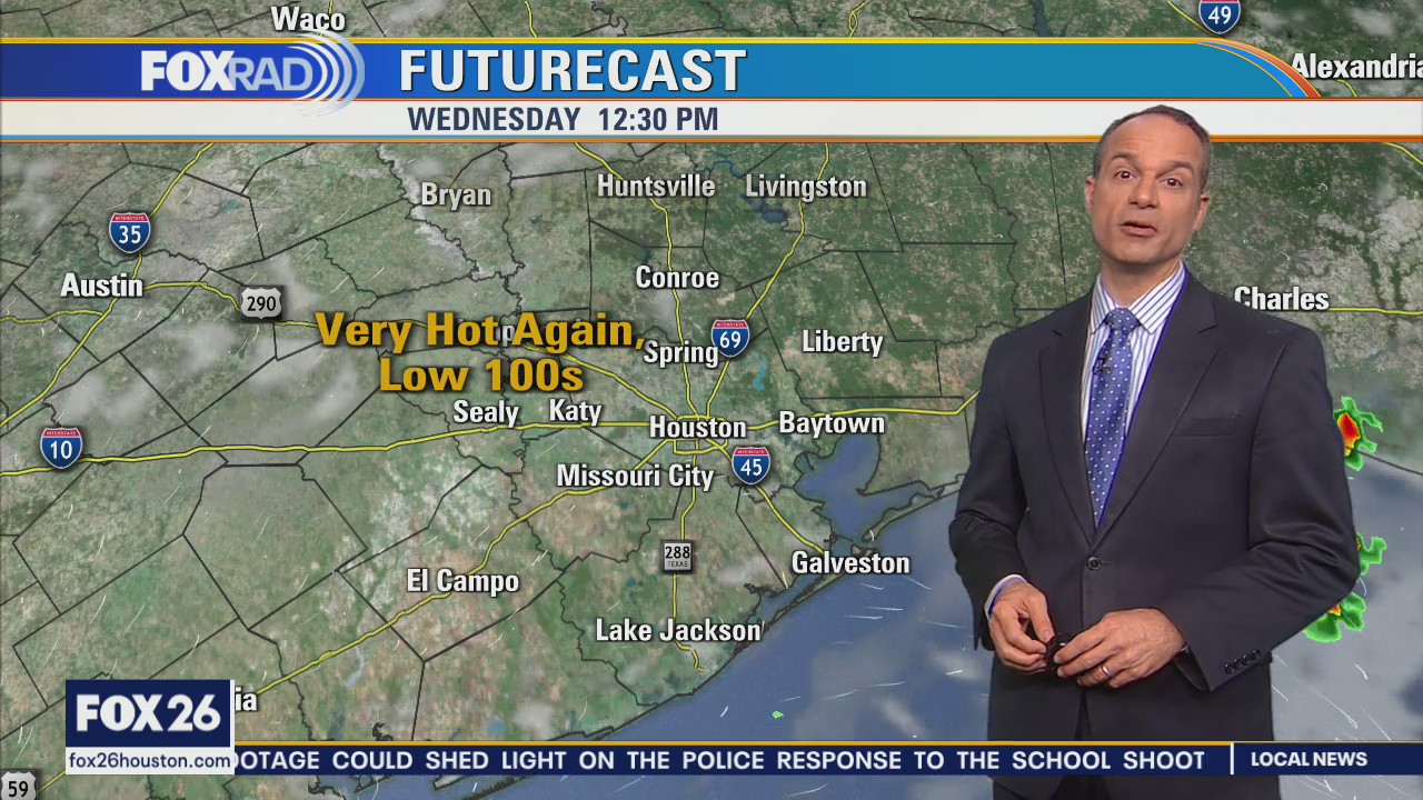
Wednesday morning weather forecast
As we continue through the rest of the week, a slightly less intense version of heat looks to continue. Some of us may squeeze out another 100 degree day or two especially farther inland. At least scattered shower and storm chances remain in the forecast daily! While still above average, enjoy the slightly subdued temperatures while they last. More 100s look apparent in our near future with another hot and dry pattern on the horizon.
As we continue through the rest of the week, a slightly less intense version of heat looks to continue. Some of us may squeeze out another 100 degree day or two especially farther inland. At least scattered shower and storm chances remain in the forecast daily! While still above average, enjoy the slightly subdued temperatures while they last. More 100s look apparent in our near future with another hot and dry pattern on the horizon.