


Severe thunderstorms rolled through Houston Thursday; less severe storms expected for Friday
Another hot and hazy day, with quiet conditions and sunshine to start and a few isolated downpours or rumbles of thunder later this afternoon. While much less coverage and intensity of storms is expected today, Saturday evening could get rowdy again if storms approaching from the north hold together. They may dissipate upon approach, and past that rain chances dwindle as a heat dome builds. Triple digit feels like values will begin this weekend, so take breaks often in the shade and stay hydrated if spending extended periods of time outdoors especially during peak heating of the day. Don't forget about your furry friends as well, and LOOK before you LOCK.
Another hot and hazy day, with quiet conditions and sunshine to start and a few isolated downpours or rumbles of thunder later this afternoon. While much less coverage and intensity of storms is expected today, Saturday evening could get rowdy again if storms approaching from the north hold together. They may dissipate upon approach, and past that rain chances dwindle as a heat dome builds. Triple digit feels like values will begin this weekend, so take breaks often in the shade and stay hydrated if spending extended periods of time outdoors especially during peak heating of the day. Don't forget about your furry friends as well, and LOOK before you LOCK.

Lightning strikes a Houston apartment complex causing a large fire
Severe storms rolled through Houston Thursday evening. Lightning struck an apartment complex causing a large fire, displacing residents.
Severe storms rolled through Houston Thursday evening. Lightning struck an apartment complex causing a large fire, displacing residents.
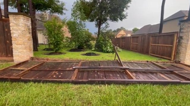

VIDEOS: Houston severe weather causes damage, fallen trees in neighborhoods
Multiple videos show how the Houston area was impacted by severe thunderstorms rolling into neighborhoods and surrounding counties on Thursday.
Multiple videos show how the Houston area was impacted by severe thunderstorms rolling into neighborhoods and surrounding counties on Thursday.

Houston weather: Flash Flood, Thunderstorm Warning issued; more than 200,000 report outages
More than 200,000 power outages were reported across Houston as severe storms continue to pour down in Harris and surrounding counties.
More than 200,000 power outages were reported across Houston as severe storms continue to pour down in Harris and surrounding counties.

Houston weather: Thunderstorm Warning for parts of Harris County, few severe storms
Strong to severe storms are possible across all of SE TX through early tonight as a disturbance moves through. Large hail, heavy rain, frequent lightning & damaging winds are all possible through about 10 PM. Storms will be dropping SE towards the coast and could get feisty. Make sure to stay alert & download our FOX 26 WX App to keep track of the threatening weather. A pattern shift is still scheduled for the weekend and much of next week with hotter and drier weather returning. We will be flirting with triple digits next week with some parts of SE TX close to heat advisory criteria by the middle and end of next week!
Strong to severe storms are possible across all of SE TX through early tonight as a disturbance moves through. Large hail, heavy rain, frequent lightning & damaging winds are all possible through about 10 PM. Storms will be dropping SE towards the coast and could get feisty. Make sure to stay alert & download our FOX 26 WX App to keep track of the threatening weather. A pattern shift is still scheduled for the weekend and much of next week with hotter and drier weather returning. We will be flirting with triple digits next week with some parts of SE TX close to heat advisory criteria by the middle and end of next week!

Tropical Weather Forecast - June 8, 2023
Tropical Weather Forecast
Tropical Weather Forecast
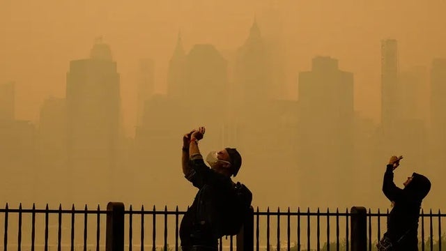

Dangerous air quality smothers major cities as Canada wildfires push smoke into US
The wildfire smoke has prompted air quality alerts from the Midwest to the Northeast and down to the mid-Atlantic and Carolinas.
The wildfire smoke has prompted air quality alerts from the Midwest to the Northeast and down to the mid-Atlantic and Carolinas.


Mars or Manhattan? Wildfire smoke draws comparisons to Red Planet
The light-scattering effect of the smoke molecules turned the sky several shades of red throughout the day Wednesday and had some asking, am I on Mars or Earth?
The light-scattering effect of the smoke molecules turned the sky several shades of red throughout the day Wednesday and had some asking, am I on Mars or Earth?

Over 100 million in eastern US warned of 'unhealthy' air as Canadian wildfire smoke spreads south, west
Choking smoke from wildfires burning in Canada continues to billow into the eastern U.S., where more than 100 million Americans will again experience "unhealthy" to even "hazardous" air quality levels.
Choking smoke from wildfires burning in Canada continues to billow into the eastern U.S., where more than 100 million Americans will again experience "unhealthy" to even "hazardous" air quality levels.

Houston weather: Isolated storms Thursday afternoon
We are looking for more afternoon storms in the Houston area today. Less expected for Friday with more heat building in this week. We may need a heat advisory next week as temperatures will get close to triple digits. Ozone Action Day again for today.
We are looking for more afternoon storms in the Houston area today. Less expected for Friday with more heat building in this week. We may need a heat advisory next week as temperatures will get close to triple digits. Ozone Action Day again for today.

Houston-weather: Severe weather possible on Thursday
Spotty storms are once again possible Thursday afternoon and evening with a few heavy downpours, frequent lightning and some strong wind gusts. There's even a low risk for an isolated severe storm with gusts near 60 mph and hail near 1". But after Thursday, our rain chances start to wind down and temperatures soar. Look for a heat dome to build in for much of next week with hot and dry weather as temperatures soar to near 100 by the middle of next week.
Spotty storms are once again possible Thursday afternoon and evening with a few heavy downpours, frequent lightning and some strong wind gusts. There's even a low risk for an isolated severe storm with gusts near 60 mph and hail near 1". But after Thursday, our rain chances start to wind down and temperatures soar. Look for a heat dome to build in for much of next week with hot and dry weather as temperatures soar to near 100 by the middle of next week.

Houston Weather: Lower floodthreat but isolated street flooding is possible due to heavy downpours
A few showers and storms are still possible through early tonight. The flood threat is much lower but I can't rule out a heavy downpour causing some isolated street flooding. Otherwise, look for us to dry out for much of the night with a bit of patchy fog possible early Thursday. Spotty storms are once again possible Thursday afternoon and evening with a few heavy downpours, frequent lightning, and some strong wind gusts. There's even a low risk for an isolated severe storm with gusts near 60 mph and hail near 1". But after Thursday, our rain chances start to wind down and temperatures soar. Look for a heat dome to build in for much of next week with hot and dry weather as temperatures soar to near 100 by the middle of next week.
A few showers and storms are still possible through early tonight. The flood threat is much lower but I can't rule out a heavy downpour causing some isolated street flooding. Otherwise, look for us to dry out for much of the night with a bit of patchy fog possible early Thursday. Spotty storms are once again possible Thursday afternoon and evening with a few heavy downpours, frequent lightning, and some strong wind gusts. There's even a low risk for an isolated severe storm with gusts near 60 mph and hail near 1". But after Thursday, our rain chances start to wind down and temperatures soar. Look for a heat dome to build in for much of next week with hot and dry weather as temperatures soar to near 100 by the middle of next week.

Tropical Weather Forecast - June 7, 2023
Things are back to being quiet in the Atlantic Basin. Our non-tropical low in the eastern Atlantic near the Azores fell apart and is no longer being monitored for development. No tropical cyclone activity is expected to develop over the next 48 hours for the Gulf of Mexico, Caribbean and Atlantic.
Things are back to being quiet in the Atlantic Basin. Our non-tropical low in the eastern Atlantic near the Azores fell apart and is no longer being monitored for development. No tropical cyclone activity is expected to develop over the next 48 hours for the Gulf of Mexico, Caribbean and Atlantic.


Hawaii's Kilauea volcano begins erupting again
Hawaii’s Kilauea volcano started to erupt early Wednesday morning, according to an alert released by the Hawaiian Volcano Observatory.
Hawaii’s Kilauea volcano started to erupt early Wednesday morning, according to an alert released by the Hawaiian Volcano Observatory.

Houston weather: Mostly sunny, hot Wednesday afternoon in the 80s
Be on the lookout for isolated to scattered downpours and storms in the afternoons today, and tomorrow. As we head into the weekend, rain chances drop but temperatures on the thermometer will begin to spike. Next week, a heat dome will build leading to several hot and dry days. "Feels Like" values will likely approach thresholds to prompt our first heat advisories of the season. Nothing is being monitored for development at this time in the tropical Atlantic.
Be on the lookout for isolated to scattered downpours and storms in the afternoons today, and tomorrow. As we head into the weekend, rain chances drop but temperatures on the thermometer will begin to spike. Next week, a heat dome will build leading to several hot and dry days. "Feels Like" values will likely approach thresholds to prompt our first heat advisories of the season. Nothing is being monitored for development at this time in the tropical Atlantic.

Houston weather: Triple digital temperatures returning soon
Live & breaking news for the entire Houston area.
Live & breaking news for the entire Houston area.
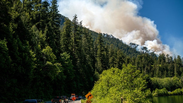

What to do when wildfire smoke smothers your area and how to keep your home's air clean
The people most at risk from wildfire smoke are individuals with lung disease, asthma, heart disease, older adults, children, and expectant mothers.
The people most at risk from wildfire smoke are individuals with lung disease, asthma, heart disease, older adults, children, and expectant mothers.
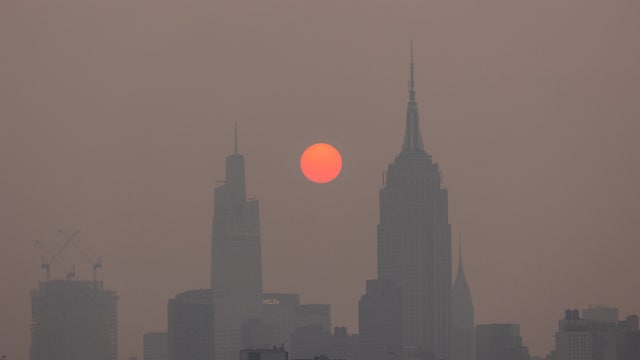

Photos: Wildfire smoke turns sun to reddish orb over Northeast
Air quality is considered unhealthy when the Air Quality Index reaches 100 or greater. Wednesday morning, Philadelphia’s AQI was 212.
Air quality is considered unhealthy when the Air Quality Index reaches 100 or greater. Wednesday morning, Philadelphia’s AQI was 212.

Houston weather: Isolated Wednesday afternoon showers/storms
We've got a few more days with decent shots at isolated afternoon downpours today and tomorrow. Temperatures will begin to spike next week as a heat dome builds and we turn the page back to a hot and dry pattern. We'll likely see our first heat advisories and triple digit days of the season soon, so brush up on heat safety for yourself, pets and little ones. Tropics are quiet with only one area being monitored way out in the Atlantic with only a 10% shot of development and it won't be coming anywhere near us.
We've got a few more days with decent shots at isolated afternoon downpours today and tomorrow. Temperatures will begin to spike next week as a heat dome builds and we turn the page back to a hot and dry pattern. We'll likely see our first heat advisories and triple digit days of the season soon, so brush up on heat safety for yourself, pets and little ones. Tropics are quiet with only one area being monitored way out in the Atlantic with only a 10% shot of development and it won't be coming anywhere near us.

Houston weather: Spotty storms possible again on Wednesday
Spotty storms are expected again Wednesday afternoon with a few more storms Thursday PM. For the weekend and next week, the pattern is expected to shift to a hotter and drier one with temperatures soaring well into the 90s and very little rain. Humidity will be high as well next week which could to some triple digit heat index values. Summer is just a few weeks away and we will start to feel more of that summer sizzle soon! Make sure to download the FOX 26 WX App to keep track of all of the latest weather changes headed our way!
Spotty storms are expected again Wednesday afternoon with a few more storms Thursday PM. For the weekend and next week, the pattern is expected to shift to a hotter and drier one with temperatures soaring well into the 90s and very little rain. Humidity will be high as well next week which could to some triple digit heat index values. Summer is just a few weeks away and we will start to feel more of that summer sizzle soon! Make sure to download the FOX 26 WX App to keep track of all of the latest weather changes headed our way!